Walk #137: Market Harborough to Northampton
 |
 |
|
General Data
| Date Walked | 10/02/2001 |
| County | Leicestershire, Northamptonshire |
| Start Location | Market Harborough |
| End Location | Greyfriars Bus Station, Northampton |
| Start time | 08.40 |
| End time | 14.57 |
| Distance | 18.3 miles |
| Description | This was a pleasant walk following an old railway line south on good surfaces. |
| Pack | Today I carried my 70-litre Craghopers rucksack with no tent or trangia. |
| Condition | I am feeling generally okay after today's walk. My feet are fine, although I have a couple of small blisters on a couple of my small toes (which are not painful or unusual as I get them regularly there and they do not bother me). I am slightly fatigued, although with a liuttle rest I could have covered a few extra miles if required. |
| Weather | The weather today was very grotty. I walked the first half-mile withou a coat on but had to put it on when it started to rain lightly. The day continued with periods of light and heavy rain, with long gaps in between. It was reasonably warm which helped me dry out between the showers, and the wind was fortunately not too strong either. |
| OS map | Landranger number 141 (Kettering, Corby & surrounding area) and Landranger number 152 (Northampton & Milton Keynes) |
Map of the walk
Maps courtesy of Google Maps. Route for indicative purposes only, and may have been plotted after the walk. Please let me have comments on what you think of this new format. For a detailed table of timings for this walk, please see the table file.
Notes
This was a very nice walk following he old Market Harborough to Northampton railway line, which is now part of the Sustrans cycle path network Route 6. The going was very easy on nice paths, and I consequently managed to roll up what had been two short day's walking into one day. It was nice to be able to get a reasonable distance under my belt as my last few walks had been considerably shorter ones. I also carried my pack for the first time in what seemed like ages, although I was not carrying my tent or trangia so it was not at full weight.
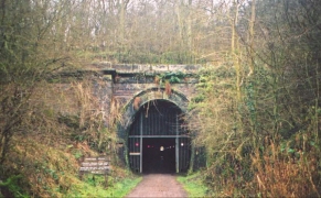
The Northamton to Market Harborough railway line opened in 1859 and was designed by Geaorge R Stephenson and George Bidder. It had six stations and two tunnels along the 17 mile length, and was finally closed on the 16th of August 1981. As such it was quite a late railway closure, and it would probably not have been closed in today's railway climate.
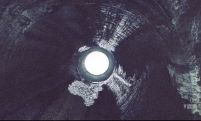
The two railway tunnels were quite exciting in a peculiar way - the darkness inside them was quite spooky, and I realise that any darkness that I had seen in recent times was not real darkness. Fron the middle of the tunnels the portals shone out like beacons, beckoning me on towards them. Each of the tunnels had a ventilation shaft, and it was exhillarating to stand below these, encircled in light, looking up at the sky through them. In the latter tunnel the rain was pouring down on me as I looked up, and it was a most pleasant experience. The path through the tunnel was quite level and easy going and only slightly wet in places, which meant that I did not need to use my torch at any time. Walking htrough the darkness was great fun.
The old station at Brampton is headquarters of the Northampton and Lamport Railway, who are hoping to reopen the railway line up as far as Lamport. They have a short running line and some interesting stock if you like that sort of thing. South of Brixworth I came across the first signs of their expansion plans - a bridge that had fencing around it which showed signs of being under repair. The fencing continued immediately to the south of the bridge and eventually rails and sleepers started appearing, laid out ready to be laid.
When walking south from Draughton I heard a strange horn sound. I switched off my walkman and looked in the direction of the sound. The sight of elegantly tailored men and women told me that there was a foxhunt going on, and this was confirmed by somehounds running across the fields beside the cyclepath. Now whatever you may think of fox hunting, the sight of the horses in full gallop was a lovely one, and I tried not to think of what they may or may not have caught.
Considering that the path I was walking on was a cycle path it was strange about hpw few cyclists there actually were, and I saw far more walkers than cyclists using the route. Indeed for the first couple of hours I did not see a singly cyclist using the route. The numbers of cyclists were bumped up by what I assume was a school group of about fifteen people, but if it had not been for these I think that I only saw about ten cyclists. On the other hand there were many joggers and walkers, although none of them seemed to be doing quite as long a distance as I was.
Having completed this walk leaves me with a multitude of new walk options open to me. The southrn end at Northampton is only five miles away from where my Grand Union Canal walk will go (an along a branch of the canal); so I will link to to that there. In the meantime I will probably walk northwestwards from Market Harborough to Leicester, and from Leicester to Loghborough. This could then be connected up with Long Eaton and my LE-JOG route, and a westerly spur from Leicester could see me getting to Birmingham.
Directions
The walk started in the centre of Market Harborough by the Tescos supermaket. Go through the supermarket car park and turn left to meet Northampton Road. Turn right down the road and cross a stream by a bridge. Head down Northampton road and thake the second road on the left after some traffic lights (signposted as Sustrans Route 6). Ths road heads east for a short distance to a park. Enter the park and turn right along an embankment and past a sign stating that this is Sustrans Route 6.
Follow the path as it heads south, soon crossing over from Leicestershire to Northamtpnshire. The navigation is very easy from now on, as you simply follow the Brampton Valley Way all the way south to the outskirts of Northampton. After a relatively short distance a tunnel is reached at Oxendon. Carefully make you way through this tunnel and emerge into the daylight at the southern end.
Continue along the Way southwards until you come to the next tunnel at Kelmarsh. Again carefully pass through this tunnel and emerge into a deep cutting. Pass through this cutting and then pass under the A14 by a concrete culvert. Continue southwards for a few miles and carefully cross the A508 road at Lamport crossing. Head south past Hanging Houghton and Brixworth to the outskirts of Chapel Brampton, where you will meet the mile-long Northanpton and Lamport Railway. The path skirts the railway southwards until it meets the A5199 road. Carefully cross the road and follow the cycle path (which is no longer path of the Brampton Valley Way), again in a southerly direction.
Now comes the only slightly difficult section of the walk. When the path starts to approach the working railway line beside some housing, and just beyond a railway viaduct over a river, turn left along a path that leads across fields, with the housing estate off to the left. The path ends at Vicarage Lane, which you join and head down towards the St John the Baptist Church in Kingsthorpe. Pass the church and turn right up a slight hill up Kingswell Road and when this ends turn left for a short distance down Mill Lane.
At a T-junction turn right down Kingsthorpe Road, the A508 once again. Follow it southwards as it heads down a hill and becomes a dual carriageway called Barrack Road, and then uphill once more. At the top of the hill it ends in a big junction. Cross over and follow the minor road which leads off slightly to the left. This road leads down to the Greyfriars Bus Station and shopping centre, from where a bus can be caught to take you back to Market Harborough.
Distances
| From | To | Distance (m) | Ascent (ft) | Descent (ft) |
|---|---|---|---|---|
| Market Harborough | Kelmarsh Tunnel | 5.2 | 328 | 154 |
| Kelmarsh Tunnel | Glebe Farm, Brixworth | 5.4 | 335 | 174 |
| Glebe Farm, Brixworth | Northampton Bus Station | 7.7 | 302 | 289 |
This makes a total distance of 18.3 miles, with 965 feet of ascent and 617 feet of descent.
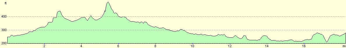
For more information on profiles, ascents and descents, see this page
Transport
The X7 bus runs about every hour between Market Harborough and Northampton, a journey that takes abot forty minutes. It stops at most of the villages in between the towns, making it a useful service if you wish to split this walk into two days.
Disclaimer
Please note that I take no responsibility for anything that may happen when following these directions. If you intend to follow this route, then please use the relevant maps and check the route out before you go out. As always when walking, use common sense and you should be fine.
If you find any information on any of these routes that is inaccurate, or you wish to add anything, then please email me.
All images on this site are © of the author. Any reproduction, retransmissions, or republication of all or part of any document found on this site is expressly prohibited, unless the author has explicitly granted its prior written consent to so reproduce, retransmit, or republish the material. All other rights reserved.
Although this site includes links providing convenient direct access to other Internet sites, I do not endorse, approve, certify or make warranties or representations as to the accuracy of the information on these sites.
And finally, enjoy your walking!
Nearby walks
| # | Title | Walk length (miles) |
|---|---|---|
| 138 | Market Harborough to Leicester | 17.7 |
| 157 | Wolverton to Bugbrooke | 16.6 |
| 158 | Bugbrooke to Braunston | 15.1 |
|
|

|