Walk #884: Marnhull to Gillingham via Stourhead
 |
 |
|
General Data
| Date Walked | 03/02/2011 |
| County | Dorset, Wiltshire |
| Start Location | Marnhull |
| End Location | Gillingham (Wiltshire) |
| Start time | 07.42 |
| End time | 15.49 |
| Distance | 21.4 miles |
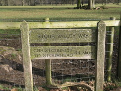
| Description | This was an enjoyable stroll following the Stour Valley Way north through Dorset to its end in Wiltshire, followed by a road walk back to Gillingham. |
| Pack | Today I carried my 30-litre Karrimor rucksack, filled with water, my waterproofs, a couple of books and other odds and ends. |
| Condition | I feel absolutely fine after this walk. |
| Weather | Today was mostly sunny, with some cloud starting to form near the end of the day. It was quite warm for the time of year. |
| OS map | Landranger number 183 (Yeovil & Frome, Shaftesbury & Shepton Mallet) |
 |
 |
|
Map of the walk
Maps courtesy of Google Maps. Route for indicative purposes only, and may have been plotted after the walk. Please let me have comments on what you think of this new format. For a detailed table of timings for this walk, please see the table file.
 |
 |
|
Notes
After the walk earlier in the week I only had about thirteen miles to walk to complete the Stour Valley Way. Since I will not be living in the area much longer, it seemed sensible to finish it off. Thirteen miles was too long to make into a there-and-back linear walk, and too short to split into two. I therefore decided to walk to the end of the way at Stourton and walk back along roads to Gillingham, from where busses would take me back to my car in Marnhull.
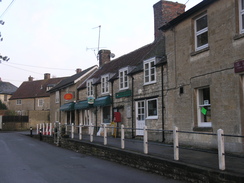
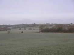
On my previous walk I noticed a car park in Marnhull, and it took me eighty minutes to reach it, arriving just after dawn. The small car park was surprisingly nearly full, with only two spaces available. I pulled up into one of these, changed into my boots and fussed around for a while before setting off. The sun was rising over the field to the east as I strolled along, making a call to make sure Sencan was getting up ready for work. This caused me to head off in the wrong direction across a field, a mistake soon found and corrected.
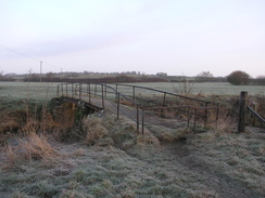
A footbridge took me across the River Stour for the first time today; it was narrow and streamlike this near its source, meandering around its wide floodplain. I often set myself a target of completing twelve miles by midday, and these small fields and frequent stiles made me abandon this target for today - the navigation was just too difficult, especially with the muddy ground. The walk up to Fifehead Magdalen was fairly uninteresting, and I just put my head down and kept on walking. At least the weather was sunny, a marked improvement on the dreary, breezy weather a couple of days earlier.
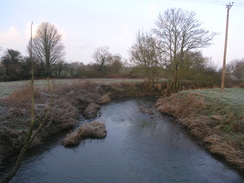
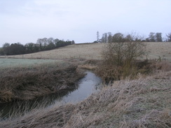
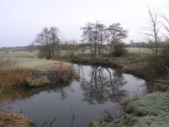
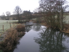
Things improved as the path headed eastwards down to Stour Provost. The river was again little more than a stream, but it made for a particularly pleasant-looking stream in the warming sunshine. The sound of rushing water marked the approach to an old mill at the bottom of the village, the water pouring out of the mill leat and into the river. Here I went wrong, joining a path that headed south before climbing up a road into the village. It was not a major mistake, but one that I was not minded to fix immediately. Instead of heading back and finding the proper route, I decided to press on.
The trail headed across the floodplain to another footbridge over the river, before climbing up into the small village of West Stour. This seemed to be dominated by a large pub that was not yet open at this early hour; a shame, as a rest could have come in useful. Despite the small fields and frequent stiles, I realised that I was about ten minutes, or half a mile, ahead of my twelve miles by midday target, and decided to see if I could make it.
I therefore sped up as the path went along a series of inauspicious fields northwards before joining a road. This angled towards a railway line, a couple of trains passing as I strolled along. More paths took me north to the west of Gillingham, heading through the village of Wyke that had been subsumed by its larger neighbour. Another path led to a long road walk towards Milton on Stour, then on to Silton.
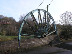
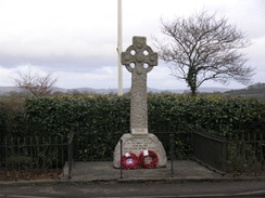
All this road walking was causing my feet to start aching, and I was not yet fully in my stride. The roads did allow me to make good time as the roads finally ended and I carefully crossed the A303 to reach Boulton. To the north the trail passed some unusual gates guarding a driveway; two spoked semi-circles of steel that looked rather like two halves of a pit wheel. Some engravings on the gateposts explained their presence: Bourton foundry was situated in the valley below; amongst other works, the foundry produced three million Mills Bombs during the First World War. There seemed to be little left of the buildings other than a few scattered and seemingly long-abandoned buildings, so the memorial was well placed to remind passers-by of the area's history. A little research shows that it was actually finally abandoned relatively recently in 1998.
More ascents and descents followed, with the adolescent Stour in the valley to the right. It crosses the river once more before climbing again, except this time it stayed high-up on the hillside. Some workmen were walking around some newly-laid concrete beside the track, and a little further on more were working around an underground reservoir. I see so many of these structures on my ramblings, and usually they are quiet, deserted places.
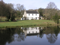
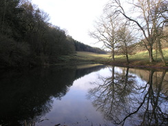
Another road and footpath took me down into the valley once more, before climbing up past a couple of lakes towards some woodlands. I was now nearing the end of the trail and entering the landscaped grounds of Stourhead House; the lakes were part of that landscaping. The trail passed through the grounds, including a pretty little cottage called Beech Cottage, nestled elegantly against the wooded hillside. At about this time I reached twelve miles at just before midday, meaning that my unexpected target had been reached.
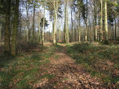
A steep climb led up the hill, unfortunately without any steps, although the ground was clad with dead leaves and was not muddy. There were no views from the wooded summit, and besides I was only interested in reaching the end of the trail. If anything the descent on the other side was steeper, but the worst stretch was at least stepped. This led down to a couple of lakes that would be superb on a summer's afternoon, but seemed a little grey and depressed despite the sunshine.
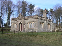
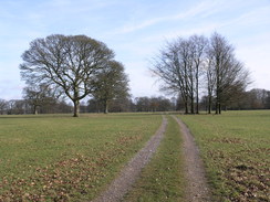
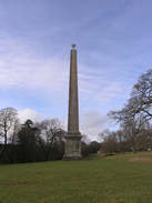
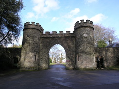
The last significant climb of the day followed, taking me up onto the hillside near Stourhead House. It emerged into some parkland beside an elegant building; I guess some form of gatehouse. Ahead I could see the obelisk that was marked on the map, which seemed to be topped with some of spiky globe. I left the trail to head towards it; it was hard to get a proper photo of it due to a semicircle of trees that surrounded it. As I approached it became clear that the globe was actually a copper depiction of the sun surrounded by jagged rays.
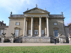
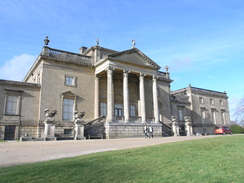
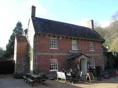
The trail ended somewhere around the front of the spectacular Palladian-styled Stourhead House, now in the custodianship of the National Trust. Couples strolled out of the main entrance as I passed, and instead of looking at it I decided to admire the views to the south. A little further on a sign stood beside the driveway, stating how water had frozen within a tree and caused a limb to fall; a great little nugget of information. I left through an archway and, having finished another trail, I decided to celebrate a little. Instead of heading straight back to Gillingham I walked down the hill towards the Spread Eagle pub, situated within a delightful courtyard.
I felt remarkably obtrusive as I strolled in with my pack, but fortunately the last mile or so of track and grass walking had cleaned most of the cloyed mud off my boots. The staff were friendly and efficient, and it was tempting to order a meal. Instead I had a pint and a pack of peanuts, a suitably low-key way to celebrate completing this little-known trail.
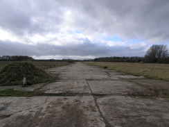
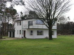
I set off feeling uproarishly happy, climbing up the steep road back towards the entrance to Stourhead. Some strange markings were shown on the map nearby, a near-rectangle of tracks. Initially I thought that they might be some form of abandoned racetrack connected with the house, but a closer look showed that it might just be the perimeter track of an airfield. When the road bisected the track I realised that the concrete pads were the remnants of an airfield. I could see a signboard in the distance, and this said that this was originally part of RAF Zeals. Aside from the perimeter track, the only other sign was the old control tower, a classic world war two design with a balcony facing the airfield. I had seen many of these before, either still in use or more often abandoned, but this one had been sensitively expanded into a home.
The road led into Zeals, and then I headed down a road called Fantley Lane. I was halfway down this when I glanced at the 1:50,000 map and realised that the A303 bisected the road. Fortunately a footpath headed off towards another road that allowed me to pass under the dual carriageway. This meant a little diversion that was not too bothersome aside from adding some more tramping along tarmac.
A long and uninteresting road walk led to Milton on Stour. I had not been looking forward to the walk from there to Gillingham along the B3092 main road, but fortunately a good cycle path had been made alongside it, separated by a hedge. It was obviously nearly school-leaving time and a stream of parents were walking up the road towards a school, many carrying scooters or small bikes for their children to ride home on.
I knew that two busses were soon going to leave to Marnhull, but had little idea where they would be leaving from. Thinking that the station was a likely candidate, I yomped through the town towards the station. My gues turned out to be correct, and I arrived about five minutes before the bus was due; a good thing, as the next one was due in two hours! It was the same service that I had caught at the end of the previous walk, and it stopped off at a school in Gillingham to pick up a load of children.
The bus dropped me off at the Crown in Marnhull, and I had to walk back to my car in the car park. It had been an enjoyable day's walks, and one made even better by the fact that it meant that I had completed another trail. On the way back I stopped off on Stour Provost and walked down to the river and mill, finding where I had gone wrong during the day. I felt absolutely fine, and the walk in the last rays of the day's sun was a fitting end to the Stour Valley Way.
 |
 |
|
Directions
This walk starts off at the car park in Marnhull at ST774193. Leave the car park and turn right to follow the road as it winds eastwards through the village for a short distance until Love Lane leads off to the left. Follow it as it heads north; as it soon curves to the right turn left to join a footpath. This heads northeastwards across a field towards a gap in a hedge. Go through this, and continue downhill aiming for the left of a house. The path joins a hedge on the right; follow this until a path runs between two hedges, descending some steps to end at Hains Lane.
Turn right along the lane for a few yards, and then turn left to cross a stile into a field. The path heads northeastwards across the field, with the hedge a short distance away to the right. Aim to the left of a house with a planked upper storey; cross into another field and turn half-left to cross a small field and reach a footbridge over the River Stour at ST782201.
Cross the footbridge, and on the other side head northeastwards across the field, aiming for another hedge, a short distance to the left of a loop in the river. Head directly north over the next three fields; cross a track and continue northwards across another field. Join a hedge on the right in the next field, and follow this northwards across another field. At the end of this join a narrow footpath that ends at road at ST781215.
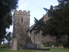
Turn right along this road and follow it as it curves around to the right, with Fifehead Magdalen church on the left. Ignore the first footpath off to the left, and take the second a short distance on. Go through a gap in the hedge and join the footpath, which initially heads eastwards with a hedge on the left. As the field starts to descend, turn left to cross the hedge into another field. Continue straight on down an obvious path downhill, aiming for a hedge just to the left of a loop in the river. Cross into the next field and follow an obvious path that skirts the northern bank of the river eastwards until a footbridge is reached at ST791215.
Cross the footbridge and then turn right across some grass to reach another bridge that controls some sluice gates. Cross this and walk a few yards towards a building. Just before the building, turn left through a gate to cross a concrete bridge over a mill stream. Immediately on the other side, turn left to walk upstream with the stream on the left. Cross a stile to enter a field, and then turn half-right to head diaganolly uphill across the field, aiming just to the right of a small stone building. Cross a stile to join a rough track that soon becomes surfaced as it winds uphill to end at road in Stour Provost at ST793215.
Turn left and follow the surfaced road northwards. When the entrance to Riverdale Farm is reached, turn right to take a green lane that skirts to the right of the farm. Shortly after this the track forks; take the left-hand fork to a stile that leads to another field. Head diagonally across the field west-northwestwards, aiming for the far right-hand corner of the field. Go through a gap in the hedge and continue on across another field, initially with a hedge and then the river on the right. This leads to a footbridge across the river at ST786222.
Cross the footbridge and then continue on uphill with a hedge on the right; the footpath jinks to the right before the top of the field, crossing a stile, a plank footbridge across a stream and another stile to reach another field. The path heads diagonally across this field for a short distance uphill; ignore a gate leading onto the road on the left, and instead cross a stile to reach a car park of the Ship Inn in West Stour.
Go through the car park to reach the A30. Turn right for a few yards along the A30, and then turn left up church Street. Follow this northwards until it curves to the left near the church; turn right to join a footpath that heads eastwards. This approached but does not join a rack, then curves to the left to started heading in a north-northwesterly direction. It passes to the left of a barn and then heads in a rough northerly direction for a little under a mile. In the last of these it angles to the right to head down to join the western bank of the river, before crossing a stile to join Nations Road at ST784242.
Follow this road northeastwards for just under a mile; when the road curves to the left to pass under a railway viaduct, continue straight on northeastwards for a fifth of a mile until the road curves sharply to the right. Here turn left to join a footpath. This heads across a field with a hedge on the right; when the hedge ends turn half-right to descend to a cattle creep under a railway line. On the other side head northwards across a field; it joins a hedge on the right before ending at a road at ST796257.
Cross the road and head for a few yards up a driveway leading to a caravan park, then turn right through a small metal gate to join a footpath. Head north-northeastwards across the field to another gate; go through this into a larger field. Cross this, aiming just to the left of the housing ahead and to the right. Do not go through the gate towards the housing, and instead head through a gap in a hedge. The footpath then heads north across another field, with the housing a short distance away to the right. This goes through another gate to join a track; this becomes Lydfords Lane before ending at the B3081 in Wyke at ST796265.
Cross the B3081 and continue straight on along Pound Lane, which twists and turns for a couple of hundred yards before ending at a T-junction with another road. Cross this road and go through the middle of three gateways opposite. This heads northwards along a short green lane before ending at a field. Turn half-right to head across the field, soon joining a hedge on the right. Follow this hedge northwards; it enters another field before ending at a bend in a road at ST795274.
Turn right to follow the road as it curves in a northerly direction. Follow it northwards for about half a mile into Milton on Stour; it descends to cross a stream before climbing up the other side. As the road curves to the right at the brow of the slight hill, turn left along a road called Pierston Fields. Follow this northwestwards for 1.8 miles as it passes through the hamlet of Silton.
At a right-hand bend at ST779301 turn left along a track that heads northwestwards. When the track ends after 150 yards enter a field and follow a hedge on the left to reach the top of some steps. Descend down these to reach the A303 dual carriageway. Carefully cross the road; there is a refuge in the barriers in the middle that offer you some protection. Once on the northern side climb another flight of steps and take a footpath that heads north-northwestwards along a broad green track that runs between hedges. Continue along this path as it skirts to the left of some new housing. The path becomes slightly confusing as a myriad of new paths have been created; just continue down a slight slope to the northwest to cross a stream, before ascending a slight slope, again with the housing on the left. This ends at New Road in Bourton at ST774306.
Turn right along New Road for a couple of hundred yards, then turn left along Bridge Street. This curves to the right; turn left up Kite"s Nest Lane for a few yards until an impressive gateway is reached on the right. Pass this and then turn right along a path that runs alongside the driveway through the gates, separated from it by a fence. The driveway ends at a house on the right, but the path continues on across a field in the same direction. At the end of this field turn half-right to head northwards, descending downhill towards a pond. Keep the pond on the left as the path continues northwards, becoming a track that ends at Coombe Lane at ST770313.
Cross the lane and take a footpath that squeezes between two stone buildings. It enters a field and starts to turn to head north-northwestwards across a field, aiming for a row of cottages. Pass in front of these, then turn left to head a few yards along the northern end of the terrace. A stile then heads off to the right to enter another field. The path descends to cross a stream, then climbs uphill on the other side to enter some trees. An obvious path leads through the trees, descending northeastwards for a short distance before reaching the River Stour at ST770319.
Cross the river on a footbridge and continue on northeastwards on a winding track that soon ends at a road. Turn left along this road; as it curves to the right turn left along a narrow track; ignore the gates on either side. Continue along this track for a few yards before crossing a stile on the right to enter a field. Head northeastwards uphill, joining a hedge on the left, and follow this hedge as it curves to the left to reach a stile that ends at a road at ST771321.
Turn right along this minor road for a short distance until it ends at a complex junction. Cross the road opposite and take a track that heads off to the left. This passes some houses on the left before entering a field. Keep the hedge on the left as it heads in a rough northerly direction for half a mile; after a while it becomes a rough track running between two hedges before ending at Bonham Lane at ST772331 opposite Bonham Farm.
Turn left and follow the road as it starts to descend. Take the second footpath off to the right, which soon enters some woodland, descending down steps to the northwest. This soon ends at a road. Cross this road and continue on northwestwards along a track called Top Lane; this coon curves to the right to head in a more northerly direction. As it curves to the left once again to approach some houses, cross a stile to head straight on towards a clump of trees on the top of the hill (called Top Wood).
Skirt the eastern side of the woodland and curve half-left to take a more northwesterly direction; you can either go direct or head down to the track and turn left. Keep Beech cottage away to the right; cross a cattle grid and then at ST766340 turn right along a footpath that heads steeply uphill to the north-northeast. It is hard going, but eventually the gradient slackens. An obvious path heads on across the summit of the hill in the same direction; ignore the many tracks that bisects the hillside. At the northern side of the hill the path drops down the slope northeastwards, with some steps to help on the steepest section.
The path reaches the side of a lake; turn right for a short distance to reach a track that heads between two ponds. Enter a field on the other side and head northeastwards towards some woodland. Turn right to join a track, and after a few yards take a footpath that heads uphill to the left, with some stepped sections. Cross a stile at the top and walk across to a track, with an elegant stone building on the left. Turn right and follow the track eastwards for nearly half a mile, passing close to an obelisk on the right.
When the track ends at a T-junction turn right to head south past the front of Stourhead House. Once past the house the track curves to the left and then the right, exiting onto a road through an elegant archway. This marks the end of the Stour Valley Way. Turn right and follow the road downhill to the southwest until the Spread Eagle pub is reached on the left.
Leave the pub and head back uphill. Follow the road as it curves to the right past the entrance to Stourhead House and continue on eastwards. Turn right to head south for 1.3 miles along Bells Lane. When this ends at a T-junction with New Road at ST782319, turn right and follow New Road southwestwards through Zeals. After a third of a mile turn left to head south down Fantley Lane. This descends slightly to cross a stream; shortly after this turn right along a good footpath that heads southwestwards; this becomes Tan Lane before ending once more at New Road at ST779308.
Turn left along New road for a few yards before turning left down another road. This loops around, heading under the A303 dual carriage way before reaching a junction with Fantley road at ST786302. Follow the road as it curves around to the right at the junction to head southeastwards for a mile and a half; it enters Milton on Stour before ending at a junction with the B3092 at ST801285.
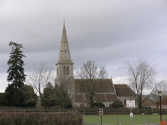
Carefully cross the road and join a broad cycle path that heads south-southeastwards alongside the road for a third of a mile. When the cycle path ends join a pavement and continue south-southeastwards along the road; continue straight on at the first roundabout, and at the second turn half-right. A fifth of a mile after this second roundabout, turn left down turner"s Lane. When this ends turn right and follow St Martin"s Square southwards past a church and into centre of Gillingham. When this road ends turn left to walk eastwards through the town along High Street. After a fifth of a mile turn right to head down Station Road; cross the B3081 road and continue on along Station Road Lower to reach Gillingham, railway station, where this walk ends.
 |
 |
|
Distances
| From | To | Distance (m) | Ascent (ft) | Descent (ft) |
|---|---|---|---|---|
| Marnhull | Stour Provost | 2.9 | 210 | 279 |
| Stour Provost | Wyke | 4.0 | 312 | 240 |
| Wyke | Stourton | 7.7 | 1007 | 758 |
| Stourton | Gillingham station | 6.8 | 174 | 489 |
This makes a total distance of 21.4 miles, with 1703 feet of ascent and 1766 feet of descent.
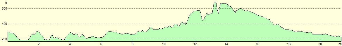
For more information on profiles, ascents and descents, see this page
Transport
Damory service 309 runs infrequent services between Gillingham railway station and Pilwell (either outside the school or opposite the Crown pub). It may be best to give them a phone rather than relying on the printed timetables.
 |
 |
|
 |
 |
|
 |
 |
|
 |
 |
|
 |
 |
|
 |
 |
|
 |
 |
|
 |
 |
|
 |
 |
|
 |
 |
|
Disclaimer
Please note that I take no responsibility for anything that may happen when following these directions. If you intend to follow this route, then please use the relevant maps and check the route out before you go out. As always when walking, use common sense and you should be fine.
If you find any information on any of these routes that is inaccurate, or you wish to add anything, then please email me.
All images on this site are © of the author. Any reproduction, retransmissions, or republication of all or part of any document found on this site is expressly prohibited, unless the author has explicitly granted its prior written consent to so reproduce, retransmit, or republish the material. All other rights reserved.
Although this site includes links providing convenient direct access to other Internet sites, I do not endorse, approve, certify or make warranties or representations as to the accuracy of the information on these sites.
And finally, enjoy your walking!
Nearby walks
| # | Title | Walk length (miles) |
|---|---|---|
| 800 | A circular walk from Hindon to Ludwell | 20.6 |
| 853 | A circular walk from Ludwell to Iwerne Courtney | 23.8 |
|
|

|