Walk #866: Ringwood to Fordingbridge and back along the Avon Valley Path
 |
 |
|
General Data
| Date Walked | 05/08/2010 |
| County | Hampshire |
| Start Location | Ringwood |
| End Location | Ringwood |
| Start time | 08.28 |
| End time | 16.05 |
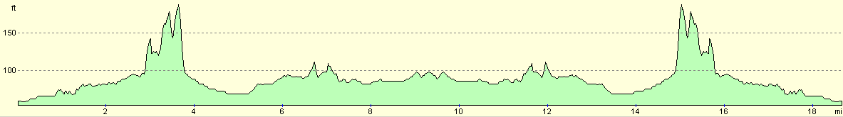
| Distance | 18.8 miles |
| Description | This was a pleasant walk following the Avon Valley Path north to Fordingbridge, and then back via the same route. |
| Pack | Today I carried my 30-litre Karrimor rucksack, filled with water, my waterproofs, a couple of books and other odds and ends. |
| Condition | I feel absolutely fine after this walk. |
| Weather | Today was a bright day, with a mixture of sunshine and cloud. |
| OS map | Landranger number 195 (Bournemouth & Purbeck, Wimborne Minster & Ringwood) |
 |
 |
|
Map of the walk
Maps courtesy of Google Maps. Route for indicative purposes only, and may have been plotted after the walk. Please let me have comments on what you think of this new format. For a detailed table of timings for this walk, please see the table file.
 |
 |
|
Notes
Today I wanted to do the next stretch of the Avon Valley Path, from Ringwood to Fordingbridge and then back again. The journey to the long-stay car park was easy enough, and I was soon strolling towards the centre of the town. The Avon Va;;y Path heads from near the Tourist Information office and diagonally across some car parks. It was easy to find the path, which soon ended at a roundabout. The noise of traffic started intruding as I headed along a pleasant lane that soon ended at a subway under the A35.
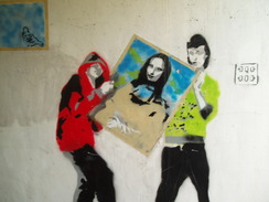
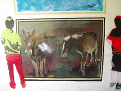
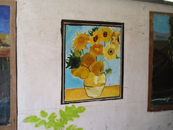
Now I have passed under many subways in my time; they are almost always dreary, dark places, sometimes smelling of various dubious liquids. I rarely feel in danger in them, but I can easily see why many people choose to cross busy roads rather than enter their dim portals. To be frank, I did not expect this one to be any different. I was therefore pleasantly surprised when I discovered that this subway was light and airy, with some wonderful paintings on its sides. This was not the usual graffiti, but stylish paintings; some depicted old masters, with people standing looking at them; one showed a youth stealing a painting off the wall. It was an amusing, welcome sight.
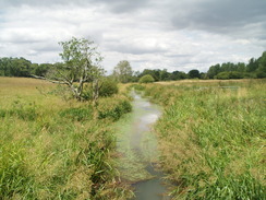
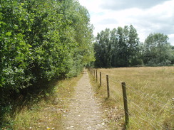
The next part of the walk took me through the northern suburbs of Ringwood, the noise of the traffic on the A35 slowly reducing. Eventually the roads were left behind, and a footpath continued on through a wooded area. Glimpses became visible over Kingfisher Lake to the right, but for most of the time it was out of view behind a curtain of trees. It was a pleasant walk despite this, and cool despite the sunshine.
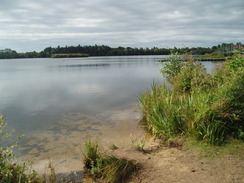
Eventually a marina became visible on a lake to the right, with lots of small sailing boats pulled up onto dry land. Glimpses of the lake became more frequent before the path dumper me out unceremoniously onto the road in Rockford. This road was quiet, and was an easy walk, including one stretch where an off-road section of path had been made; rather redundantly today, as not a single car passed along the adjacent road. I passed a pub with the curious name, the Alice Lisle.
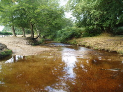
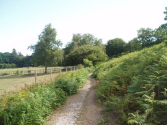
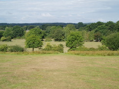
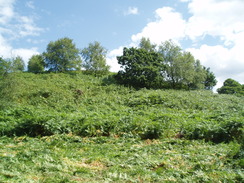
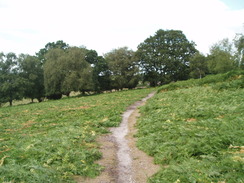
The road took me on to a pretty ford over Dockens Water, and then past the Moyles Court School. Shortly after the school the path left the road and climbed up onto the hillside to the east of the village, and this marked the start of a wonderful stretch of the walk, with bracken lying on either side of the path. It made for a wonderful stretch of the walk, with some reasonable (if not glorious) views across the Avon valley to the west.
I passed a house in Mockbeggar, and I stopped for a minute to open gates for a young woman who was taking a horse between fields. I was feeling really happy at this point, and the last stretch of path had really lifted my spirits, which had hardly been low to begin with. It was a shame when the path left the hillside and descended down to the valley floor, crossing a road and heading across the floodplain towards a series of lakes.
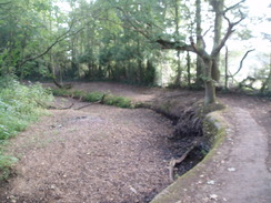
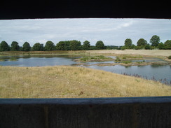
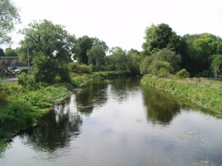
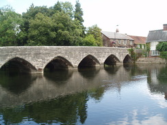
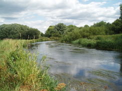
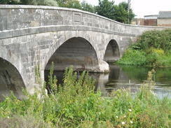
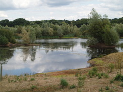
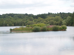
These had obviously been used for aggregate or clay extraction, and were just being reclaimed by nature. A small bird hide had been made, and I can imagine that in a few years this whole area would be a thriving ecosystem. Unfortunately the lakes ended all too soon, and I was dropped out onto the Ringwood to Fordingbridge road immediately to the north of Ibsley. A pub sign was visible immediately to the left, but I chose to walk on. A pretty old bridge took me over the River Avon, the first time the river has been seen today.
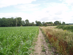
The path followed the river for a short distance, and there were some pleasant views to be had across it, including an area where a flight of geese had made a home, the grass around them covered in downy feathers. All too soon the river was left behind as a footpath and track headed towards Harbridge Farm. This marked the start of a long - and indirect - northwards walk to Fordingbridge. Whereas the middle part of this walk was spectacular, this stretch was somehow unsatisfying, with small fields and frequent roads to contend with.
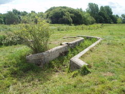
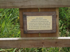
Things improved when I reached a wooden causey and Jim's Bridge, which carried the path over a stream. A plaque on the bridge stated that this was the last part of the Avon Valley Path to be opened in 1989. From here on to Fordingbridge the path remained on the floodplain, although the river itself remained stubbornly out of sight. Occasional lumps of concrete appeared in the grass, looking something like junctions in drainage channels. These were spread over rather a large area, and one had '1919' etched into the concrete, a useful and long-lasting piece of graffiti. I have no idea what they were, but can only imagine that they were something to do with a sewage works or similar. If so, then I am surprised that they were not demolished along with the rest of the structures.
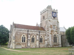
The path entered Fordingbridge by going through the churchyard, the spectacular church looming overhead. I had driven through Fordingbridge in a couple of occasions, but had never stopped, and so it felt good exploring it properly for the first time. It seemed like a small but perfectly-formed town, with plenty to see and do. I walked through a little further than I needed to, before turning around to find somewhere to stop. Eventually I found the George, nestled neatly beside the river. This looked like a posh place - for the second week in a row I felt distinctly out of place - but I ordered my usual and went to sit outside by the river.
A few people were scattered about, and I sat down at a bench and got a book out of my rucksack. However there was too many other things to watch to read, including lots of ducks on the river. These were crowding on the water near the pub and it was soon obvious why - a family sat at the table next to mine and started feeding them. A couple of swans paddled elegantly around the edges of the fray, as majestic as the ducks were plain.
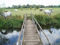
Eventually I decided to head off once more. I was a bit hungry, and when I passed a chip shop I nipped in and bought a pack of chips, which I demolished as I headed back towards the church. The return journey flew; a drove of horses were standing around a footbridge near Harbridge Farm, and I had to carefully shoo them away before crossing the bridge. The only other thing at note was on the hillside to the south of Mockbeggar, where the wonderful bracken-strewn hillside had been devastated when I returned. A tractor was mowing down the bracken, and the wonderful smell that hung in the air was no compensation for the destruction. I can only guess that the mowing was a necessary part of the maintenance regime for the hillside, but it was a shame nonetheless.
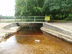
I stopped off for an ice cream at the Dockens Water ford. The lady who served me told me that the ford had just been rebuilt - explaining the new concrete under the water - and that the road had been closed whilst this had been done. She had paid for the pitch over the summer, and had lost lots of income due to the closure. The nearby lakes had been deserted when I had passed them this morning, but now several boats were sailing gracefully around. It was a pleasant sight, and I stopped for a couple of minutes to watch them float by.
I soon reached the centre of Ringwood. The return journey had absolutely flown, and I was not feeling too bad by the time I finished. It had been a very good day's walk, and this leg of the Avon Valley Path, although not spectacular, is far better than the stretch between Christchurch and Ringwood. For the second walk in a row I have found a there-and-back walk to be enjoyable; I have always avoided doing them in the past, preferring to do circular walks instead. Perhaps I ought to try more of these...
 |
 |
|
Directions
This walk starts off at the long-stay car park in Ringwood. Leave the car park and go to the roundabout that leads into it, the n continue south along The Furlong. When the road junction by the Tourist Information office is reached, turn left towards the bust station, then turn left once more to start following a path that heads diagonally northeastwards across the car park. This reaches a road immediately to the west of a roundabout; carefully cross the first road, and then turn right to head east across Mansfield Road. On the other side walk a few yards to reach the southern end if Gravel Lane.
Turn left and start following Gravel Lane northwards. The road curves slightly to the right before ending at a sliproad that leads down from the A35. Cross the sliproad and then head under the subway under the A35. On the other side is another sliproad; cross this and continue on northeastwards along the continuation of Gravel Lane. This ends at a complex junction with Northfield Road; continue straight on northeastwards along a path, with a garage on the left.
The path ends at a T-junction with Hurst Road. Turn right and follow the road eastwards until it reaches one end of an oval road. When the road forks, take the right-hand fork and follow the road as it curves around the southern side of the oval. When the roads join once more, continue on to the end of a short road. At the end of the road turn left along a path. This immediately enters an area of woodland, with Kingfisher Lake immediately to the right, although out of view.
The path winds through the woods in a rough northerly direction, crossing a stream on a bridge before ending at a lane at SU155071. Turn right for a few yards towards the entrance of a yacht club, and then turn left to rejoin the oath. This heads along the western edge of Blashford Lake, initially heading north before taking more of an easterly course and ending at a road at SU160078 in Rockford.
Turn left and start following the road northeastwards; after passing the Alice Lisle pub away to the left, a footpath starts to the left, running parallel to the road but separated from it by a hedge. The short stretch of path ends when a road comes in from the left; continue straight on along the road that heads eastwards for a short distance until it reaches a road junction at SU162083. Turn left to immediately cross a ford over Dockens Water, and continue on northwards as the road passes Moyles Court School. At SU161086 turn right along a footpath that climbs uphill to the east for about fifty yards; when some trees are reached turn left to start heading north, with the trees on the right and paddocks on the left.
When the trees end, the path plunges into an area of moorland. The path skirts the flank of the hill, hardly climbing as it curves to take a more northeasterly course before descending to cross a stream and track. Cross these and continue on along the path that heads north around the western tip of Summerlug Hill, with houses on the left. The path descends to meet another track, and at SU164097 turns to the left to head west. It descends down a slight slope to the valley floor, crossing two fields before squeezing past a village hall and ending at a road at SU161098.
Turn right along this road for a few yards, and then turn left to join a footpath that goes through a gate beside a large gate. This path heads westwards for nearly a quarter of a mile with a hedge on the left; it then turns sharply to the right to head north for about a hundred yards with a small house over a hedge on the right. These directions are different to the route shown on the 1:25,000 OS maps, which takes a rather impossible route straight across the lakes. The path makes another sharp-left turn to head west along the northern edge of the lakes. It soon turns to the left once again, and then half-right to head southwestwards. Eventually it turns to the right once more, heading west to reach the A338 Salisbury Road.
Carefully cross the A338 and then cross the bridge over the River Avon on the other side. On the western side of the bridge turn left down some steps to reach the floodplain. Turn half-left to start heading west-southwestwards; the Avon is met, left and rejoined in short succession, before being left behind as the path continues across the floodplain. A footbridge over a stream is crossed, which leads to a track. Cross this track and head straight on along another track that heads west-northwestwards for a couple of hundred yards until Harbridge Farm is reached.
A track leads off to the left; immediately after this turn right to join a footpath that heads north-northeastwards with a hedge on the left. Cross a stile at the end of the first field, and then head north to reach Kent Lane at SU141102. Turn left and follow the lane as it heads west for a few yards, before curving to the right; immediately after a left-hand bend turn right to join a footpath. On the map the path curves across the field; instead, on the ground the path turns sharply to the right to follow the edge of the field. After a short distance it turns to the left to start heading northeastwards along the edge of the field beside a hedge.
A gate is reached at the northeastern corner of the field. This leads to a track that heads in a rough northerly direction, eventually reaching a road at Harbridge Green. Turn right along this road; it immediately curves to the left, and then turn left to join a footpath. This heads northwestwards towards a stream, and then curves to the right to head northwards up a slight slope. A stile beside a gate is reached, on the other side of which is the road at SU142113.
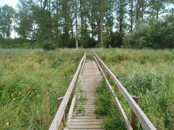
Turn right to head downhill along the lane, passing a farm on the right. When a track is reached on the left, turn left and follow it as it heads northwards. After a couple of hundred yards the track curves to the left and then the right, before a footpath leads off to the right This heads eastwards, with a hedge on the right. It crosses a stile into another field and then descends down to meet a boardwalk. Join this and follow it over Jim's Bridge, which carries the path over a stream and into a boggy, weed-lined area of ground. The boardwalk turns sharply to the left to head northwards.
The boardwalk soon ends, and a couple of hundred yards further on the path jinks to the right and then the left to head in a north-northwesterly direction, with a stream on the right. The footpath curves to the right for a short distance before ending at a track. Turn right at this track and cross a stream; a short distance further on turn left to continue northwards. It enters a confused, jumbled area of land, flat but with lots of small, disjointed hedges. Fortunately the waymarking is good as it heads to meet the end of a track beside a sewage works at SU143130.
Follow this track as it heads north-northeastwards for nearly half a mile, curving slightly to the left to take a more northerly course before ending at a junction with another road directly opposite the church. Cross the track and enter the churchyard; follow a path north directly past the east end of the church, heading for the lychgate. Head through this and out onto Church Street. Turn right and start following Church Street northwards; it becomes Provost Street that ends at a junction with the High Street. Turn right and follow the High Street northeastwards until a roundabout is reached with Bridge Street, in the centre of the town.
The rest of these direction detail the same route heading north to south.
Head southwestwards down the High Street until a junction with Provost Street is reached on the left; turn left down this street and follow it as it becomes Church Street. When the lychgate is reached, had through it into the churchyard and then follow the path that skirts the eastern end of the church before ending at a track. Cross this track and join another one, which heads south and then south-southwest for about half a mile before ending at a field beside a sewage works.
At the end of the track turn left to head east for a few yards, before turning to the right to head across an area of rough ground with small fields; initially it curves towards the river, before heading south to meet a track at SU144124. Turn right to head west along this track for a short distance; it crosses a stream and then turn left to join another footpath. This soon curves to the left to take a south-southeastwards direction across a couple of fields to SU145119. Here the path turns to the right and then almost immediately to the left, to continue on south-southeastwards.
The path curves to take a more southerly course, joining a boardwalk as the path enters a boggy area of ground. The boardwalk turns sharply to the right to cross Jim's Bridge, and then the path climbs uphill to the west, with a hedge on the left. The path ends at a track at SU143116; turn left down this track and follow it southwards for a few hundred yards until it ends at a road. Turn left along this road to head westwards up a small slope.
A footpath soon leads off to the left, heading south across a small field. It enters another field and curves to the left to take a more southeasterly course, crossing a stream before ending at a road in Harbridge Green. Turn right along this road and follow it as it curves immediately to the right. Take the first track off to the left and follow this south-southwestwards. When the track ends beside a house, go through a gate and start following the left-hand edge of the field (on the 1:25,000 OS map the path heads through the field; on the ground it follows the edge). When the southeastern corner of the field is reached, turn right for a few yards to a stile on the left. Cross this stile to gain access to Kent Lane on the other side.
Turn left and follow this road as it gently curves to the left; after a sharp left-hand curve a footpath leads off to the right. Take this footpath as it heads south, soon joining a hedge on the right. Keep the hedge to the right as you head southwestwards, passing Harbrdge Farm before ending at a track beside the farm at SU138097.
Turn left and follow the track east-southeastwards until it ends at a T-junction with another track. Cross this track and enter a field on the other side; immediately cross a footbridge over a stream and follow the path eastwards across the floodplain to reach the River Avon. The path skirts the northern bank of the river before climbing up to reach a road on the westerly side of Ibsley Bridge. Turn right to cross the bridge and reach the A338 Salisbury Road.
Carefully cross the A338 and take a footpath that heads eastwards on the other side for about 150 yards. When this ends at a T-junction with another footpath, turn left and follow another path northeastwards for a fifth of a mile, with lakes on the right. The path curves to the left for a few yards, before turning to the right to head eastwards, again with the lakes on the right. At the end of the lakes the path turns to the right with a house on the left, following a field boundary southwards. After a short distance the path turns sharply to the left to head eastwards for a quarter of a mile with hedges on the right. This path soon ends at a road at SU161098.
Turn right to head south along this road for a few yards, and then turn left up a track that heads towards the village hall. Before this is reached turn right to enter an area of rough ground and then left to head eastwards across a couple of fields, climbing up a slight slope before reaching a track. Turn right along this track for a short distance and then take a footpath that angles up the flank of Summerlug Hill in a rough southerly direction. It soon descends again to meet a track at SU165095.
Cross the track and descend down to a cross a stream on a plank bridge, then start ascending the other side. The path soon curves to the right to head southwards, entering an area of moorland as it curves to take a southwesterly course as it flanks the side of the hill. It then heads southwards, leaving the moorland via a stile and continuing on with an area of trees on the left. At SU162086 take a footpath that leads off to the right, heading downhill to the west for a short distance to reach a road.
Turn left down this road and follow it southwards as it passes Moyles Court School to reach a ford over Dockens Water. Cross the ford to reach a T-junction on the other side. Turn right to head westwards along this road; after a short distance it curves to the left to take a south-southwesterly direction; there is a footpath that runs alongside the road to the right, just on the other side of the hedge. This ends just before the Alice Lisle pub. Continue on south along the road to a crossroads; head straight on, and after a few yards take a footpath that heads off to the right, immediately beside a house.
This path heads west-southwestwards immediately to the north of Blashford Lake; it curves to the left to reach a track near Ivy Lane. Turn left to start heading south along the western edge of Blashford Lake. When this path ends at a track, turn right for a few yards and then left once again to head southwards. After a short distance a path leads off to the left; ignore this and follow the main path as it heads in a more southwesterly direction along the western edge of Kingfisher Lake.
The footpath ends at the end of Hurst Road. Turn right down Hurst Road to reach an oval road. When the road forks take the left-hand fork and walk around the southern side of the oval, and then on westwards along Hurst Road. Take a surfaced track that leads off to the left, heading south before ending at a complex junction or Northfield and Salisbury Roads. Head straight in along Salisbury Road, then immediately left down a surfaced path, a continuation of Gravel Lane.
This heads south-southwestwards through the northern outskirts of Ringwood before reaching a sliproad that leads up to the A35. Cross this sliproad, and then pass through an underpass under the dual carriageway. On the other side cross another sliproad, and then continue on along a continuation of Gravel Lane. Just before this ends, turn right and cross Mansfield Road immediately to the north of a roundabout.
On the other side turn left to cross another road, and then follow a footpath that runs between hedges southwestwards through a car park. This ends at a road between the Tourist Information office and the bus station in the centre of Ringwood. The Avon Valley Path here is left behind for a short distance; turn right to head north up The Furlong to reach a roundabout; the long-stay car park in Ringwood is immediately to the north, on the other side of the roundabout.
 |
 |
|
Distances
| From | To | Distance (m) | Ascent (ft) | Descent (ft) |
|---|---|---|---|---|
| Ringwood | Ibsley | 4.7 | 233 | 220 |
| Ibsley | Fordingbridge | 4.7 | 112 | 85 |
| Fordingbridge | Ibsley | 4.7 | 85 | 112 |
| Ibsley | Ringwood | 4.7 | 220 | 233 |
This makes a total distance of 18.8 miles, with 650 feet of ascent and 650 feet of descent.
For more information on profiles, ascents and descents, see this page
Transport
The Wiltshire and Dorset bus company run busses between Ringwood and Fordingbridge, as part of their Bourenmouth to Salisbury X3 service.
 |
 |
|
 |
 |
|
 |
 |
|
 |
 |
|
 |
 |
|
 |
 |
|
 |
 |
|
 |
 |
|
 |
 |
|
Disclaimer
Please note that I take no responsibility for anything that may happen when following these directions. If you intend to follow this route, then please use the relevant maps and check the route out before you go out. As always when walking, use common sense and you should be fine.
If you find any information on any of these routes that is inaccurate, or you wish to add anything, then please email me.
All images on this site are © of the author. Any reproduction, retransmissions, or republication of all or part of any document found on this site is expressly prohibited, unless the author has explicitly granted its prior written consent to so reproduce, retransmit, or republish the material. All other rights reserved.
Although this site includes links providing convenient direct access to other Internet sites, I do not endorse, approve, certify or make warranties or representations as to the accuracy of the information on these sites.
And finally, enjoy your walking!
Nearby walks
| # | Title | Walk length (miles) |
|---|---|---|
| 796 | Romsey to Salisbury via Dean Hill | 23.6 |
| 801 | A circular walk from Brockenhurst to Burley | 23.5 |
| 806 | A circular walk from Ringwood | 23.2 |
|
|

|