Walk #703: A circular from Baslow to Monsal Head and Eyam
 |
 |
|
 |
 |
|
General Data
| Date Walked | 27/12/2005 |
| County | Derbyshire |
| Start Location | Baslow car park |
| End Location | Baslow car park |
| Start time | 08.57 |
| End time | 16.12 |
| Distance | 18.2 miles |
| Description | This was an enjoyable stroll through some beautiful parts of the White Peak. |
| Pack | Today I carried my 30-litre Karrimor rucksack filled with my waterproofs, a book and various other odds and ends. |
| Condition | I feel absolutely fine after this walk, and I could have walked further if the light had allowed me. My knees gave very occasional aches, but these were not very concerning, and my left ankle did not hurt at all. |
| Weather | Today was a very mixed day, with periods of bright sunshine being followed by overcast periods and snow showers. It was not a particularly cold day and the wind was not too fierce, which meant that I did not get too cold. |
| OS map | Outdoor Leisure number 24 (The Peak District - White Peak Area) |
 |
 |
|
 |
Map of the walk
Maps courtesy of Google Maps. Route for indicative purposes only, and may have been plotted after the walk. Please let me have comments on what you think of this new format. For a detailed table of timings for this walk, please see the table file.
Notes
Heavy snow was forecast for eastern areas last night, and although it was not forecast to be as bad in Derbyshire I decided to wait until morning to decide if I was going to be doing a walk today or not. Therefore the first thing that I did once I woke up was look out of the window and, after seeing a heavy frost but no snow, resolved to go for a walk. As I drove out of Ashbourne there were signs of snow on the road where the gritter had missed, and as I got higher the fields got a sheen of white, although in most places the green of the grass showed through. I arrived at Baslow a little later than I wanted due to a stop for some petrol, and after I paid the rather extortionate £4.20 for a day's parking, I pulled my gear on and set off through Baslow.
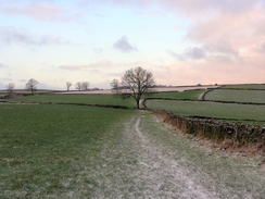
At this time in the morning the village was quite quiet, and as a few snow flurries blew around me I passed the attractive church reached the old bridge over the river. For some reason I found it difficult to find the footpath that leads uphill directly opposite the bridge, but after searching in both directions for a few minutes and studying the map closely I found the narrow entrance right where I had been initially looking. This footpath led uphill and as it climbed I could not help but look behind me to study the superb views east over towards the gritstone edges that rise above Baslow. There were some patches of snow on these edges, but it was not as deep or widespread as I had expected after the overnight snowfalls.
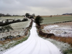
The footpath was slightly muddy, and I was relieved when it reached a road, and I followed this onwards towards Hassop. Here I had a choice; I could either continue along the road into Hassop and then onto Great Longstone, or I could take a diversion that kept off roads and onto footpaths. After a little thought I decided on the latter alternative, and I joined a footpath that headed north alongside some woodland. Initially the views eastwards from this footpath over towards the gritstone edges were superb, but the path eventually plunged into the woodland and although the walk was pleasant I missed the views somewhat.
After crossing the B6001 I followed a quarry track westwards, climbing uphill along the edge of a quarry (indeed, there was a diversion where the quarry had expanded slightly), to reach a confusion of track junctions at the top. It was not clear which one was the correct one to take, but more by luck than choice I discovered I was following the correct one, which headed downhill southwestwards. As I walked a stream of off-road bikers passed me, and the noise of the engines intruded into the silence of the morning; I have not had very good experiences with off-road bikers recently and although this track was ideal for them (it had a very firm surface and was unlikely to get too rutted) their presence still seemed to be an intrusion.
Eventually I left the track and followed a series of lanes and footpaths southwestwards down into the pretty village of Great Longstone. As I passed the church in the village it started to snow, and as I headed uphill towards Monsal Head the snowfall got increasingly heavy. My map case had a solid covering of snow by the time that I reached the hotel at the top, and I was annoyed to find that the pub (a traditional stopping-off place for me) was shut. The walker's bar was due to open at 11.30, and as this was only a few minutes away I waited. It got to 11.35 and as the bar had still not opened I decided to get out of the snow by going into the adjacent café. Here I purchased a mug of hot chocolate and a jacket potato, but the mug was relatively small and the jacket potato was similarly disappointingly sized.
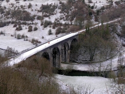
I ate up the food and, later than I wanted (I had initially only intended to nip in for a quick pint), set off on the walk. Fortunately the snow had stopped, but this made no difference to the steep steps that lead down to the Monsal Head viaduct. These were covered in patchy ice and were consequently very slippery; after a few steps I was forced to stop and get my walking poles out to aid me on the descent. Despite this my feet were slipping and sliding on the descent, and others also descending were having similar difficulties. Eventually I reached the viaduct and was greeted with the magnificent views that you get from the viaduct. The next mile or so was an easy walk along the Monsal Trail, and when the Cressbrook tunnel was reached a footpath led off, skirting the hillside before descending downhill towards the River Wye at Cressbrook.
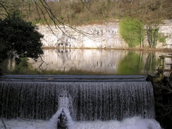
A footbridge led across the river and I was then greeted with a magnificent sight; a high wall of limestone beside a large pool in the river, the limestone face reflecting perfectly in the water below. It was a sight that I had seen before but it still took me breath away, and I paused to study it and watch walkers skirt between the bottom of the cliff face and the river. I could have viewed this scene all day, but I was concerned about whether or not I cold complete the walk before dark, so I headed on, passing the Arkwright-built Cressbrook Mill (now tastefully converted into flats) and started walking along a road.
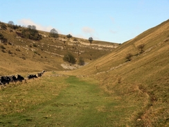
This road climbed quite steeply into Cressbrook Dale and it was quite a tiring climb, but before long a footpath led down a surfaced track towards Ravensdale Cottages. These cottages are nestled in the dale in a beautiful location, with high, craggy limestone cliffs rising behind them on the other side of the river. From the cottages the path entered an area of scrub woodland that I did not enjoy too much; the river was essentially dry and the path muddy, with the trees leafless and looking dreary. In spring this could look very different, but in winter it was not too spectacular. This all changes when the woodland ended, and I found myself walking along a superb dry valley with high valleys walls rising up on either side. The sun was low in the sky and was castling long shadows over the valley sides, and I found myself loving the walk.
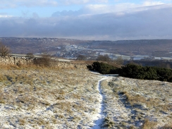
The path passes a spectacular outcrop of rock called Peter's Stone before ending at the A623 road at Wardlow Mires. From here it had been my intention to follow footpaths north and east to Housley, but as time was pressing I decided to do a little short-cut and walk along the road instead. This was not too pleasant as the road was quite busy, and I would thoroughly recommend walking along the footpaths instead. After a mile a track led off from the road, and I thankfully took this and it proved to be an easy walk eastwards into Eyam. As I walked I could see a thick cloud over the valley ahead and snow falling, the clouds a dirty grey rather than the white I expected.
Despite a few little snow flurries I escaped the worst of this snowfall, and I soon found myself walking past Eyam Hall in the centre of the village. Eyam is famous for an event in 1665 and 1666, when the plague arrived in the village. Nowhere else in the area had the plague, and rather than spread it the local vicar decided to cut the village off from the rest of the area. Consequently no-one came or left the village and although many of the villagers died the plague did not spread. Walking through the village was quite a sobering villages, as many of the house shad plaques outside showing how many people had died inside them. The village itself is quite pretty, although the history rather than the architecture made me think as I walked through.
A footpath led me out of the village, towards the Boundary Stone - this stone, which sits on the boundary of the Eyam and Stoney Middleton parishes, was the place where residents of Eyam left money during the plague, in exchange for goods that were left there. The stone has six holes in it that were filled with vinegar, which was believed to disinfect the money that the Eyam villagers left there. It is in a beautiful location, with some great views available from nearby over Stoney Middleton and the Derwent Valley.
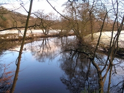
When I reached Stoney Middleton it was starting to get darker, and so I decided to walk down the A623 road towards Calver. There was a pavement beside the road and so it made for an easy walk, and once in Calver Slough I nipped into a petrol station to buy a pack of crisps. These entertained me as I walked into Calver, and when I reached the bridge over the River Derwent I left the road and started heading south along a footpath. As I walked it started to snow, and walking through the heavy snowstorm with the sky reddening as the day drew to a close was a magical experience, and I started singing as I strolled along.
The footpath soon ended, and I road led on to the old bridge over the river that I had crossed earlier in the day. It was then simply a case of following roads back through Baslow to the car park, and I reached my car just as the last of the daylight was disappearing. The car park was much fuller than it had been earlier in the day, and as I pulled off my gaiters and waterproof trousers I could look back on what had been an extremely enjoyable day's walk.
Directions
This walks starts off at the main car park in the village of Baslow. Leave the car park and by the toilets turn left, to start walking westwards along the main road for a few hundred yards until a large roundabout with the B6012. Here turn right, and start heading northwestwards along the A623 through the village. Pass the church on the left, and then turn left along a road that leads to an old bridge over the river. Once over the bridge a footpath leads off uphill directly opposite; the entrance to this is small and difficult to spot. The footpath is easy to follow as it leads uphill in a rough westerly direction, keeping walls to the right until it ends at Wheatlands Lane.
Head west along the lane for a little under a kilometre until a footpath leads off to the right . This climbs up to skirt to the eastern side of some woodland, and was easy to follow as it eventually plunges into the woodland and descended to end at Bramley Lane. Turn left along this lane and walk downhill for a few yards to a junction with the B6001; cross this road and continue straight on along a track that climbs uphill directly above Back Dale Mine. Keep heading on a rough westerly direction towards the top of the mine, and then turn left along another track that starts to head southwestwards downhill.
Eventually this track becomes walled-in on both sides, and after another hundred yards turn right along another footpath. This heads westwards uphill across a field for a short distance to another track; cross this, and continue on along a footpath that crosses a series of fields before reaching the end of Hardrake Lane. Start following Hardrake Lane as it heads southwestwards downhill, and when it curves to the left around a little knoll leave the lane and turn right to join another footpath that heads southwestwards across a couple of fields to end at another track. Turn left along this track and follow ir as it curves around for a short distance to end at a road in Great Longstone.
Turn right and follow the road as it curves around past the church and ends at a T-junction. Here turn right and start following another road as it heads westwards for about a mile, passing through Little Longstone before climbing uphill to reach the B6465 road at Monsal Head. Cross the B6465, and go towards the little car park to the right of the Monsal Head Hotel. Follow the road as it curves sharply to the right and after a couple of yards turn left through a gap in the wall and turn right to start heading steeply downhill along a series of stone steps. This path curves to the left before ending at the western end of the Monsal Head viaduct.
Turn right and start heading northwestwards along the Monsal Trail as it passes the site of Monsal station, and after about a mile the portal of Cressbrook tunnel is reached. This tunnel is closed, and so the footpath heads off to the right, skirting the hillside before descending steeply down some steps to reach the River Wye at Cressbrook Mill. Cross the river by the footbridge, and on the other side leave the Monsal Trail by turning right. The path leads towards the mill, and then skirts along a narrow path beside the mill before ending at a road. Turn left and follow this road; when it forks take the right-hand branch and continue along this road as it steadily climbs up into Cressbrook Dale.
After a few hundred metres a surfaced track leads off to the right; turn right and follow this track as it heads downhill, eventually reaching the valley floor by a set of cottages at Ravensdale. Keep these cottages to the right and when the road ends continue straight on along a footpath. That enters a wooded area. The footpath continues onwards northwards along the eastern bank of the river; ignore any branches that head off to the right uphill and continue along the river until it emerges out from the trees. Here the valley is dry, the river having disappeared to a trickle, and so continue along the floor of the valley as it curves around several times before eventually emerging out onto the A623 road at Wardlow Mires.
Turn right and carefully start walking eastwards along the A623 road for about a mile towards Housley. At the second road junction to the left (leading to Foolow) turn left along this road and then immediately right, to start following a track eastwards. This track falls into a dip and then climbs out the other side, before continuing on into Eyam. Once the path passes Fairview Farm and curves to the left turn right and head eastwards down a footpath; this soon crosses a small road and heads downhill along residential streets before ending at the main street through the village.
At the road turn right and start following the road as it passes Eyam Hall and the village church before reaching the main square in the village. Here take a track that leads off uphill to the south, and when this track ends take a footpath that leads off straight ahead, way marked for the Boundary Stone. The path heads southeastwards and passes the Boundary Stone before descending steeply and ending at a road in the village of Stoney Middleton. Follow the road through the village and pass the church, and when the road ends at the A623 turn left and start following this main road southeastwards for about a mile and a half as it passes though Calver Sough and reaches Calver.
Once the road reaches the bridge over the River Derwent in Calver turn right and descend some steps to reach the western bank of the river. Here turn right and start following a footpath that heads south downstream beside the river. This path eventually leaves the river and climbs uphill slightly, and after a kilometre ends at a road. Turn left and start following this road as it heads south, again alongside the river, and when the old bridge over the river is reached after about half a mile turn left and cross the river by the bridge. Once on the other side turn right and follow a road that skirts around the church before reaching a large roundabout; at this roundabout turn left and walk eastwards through the village until the car park is reached, where this walk ends.
Distances
| From | To | Distance (m) | Ascent (ft) | Descent (ft) |
|---|---|---|---|---|
| Baslow | Monsal Head | 6.8 | 1125 | 755 |
| Monsal Head | Eyam | 6.9 | 1335 | 1289 |
| Eyam | Baslow | 4.5 | 249 | 665 |
This makes a total distance of 18.2 miles, with 2709 feet of ascent and 2709 feet of descent.
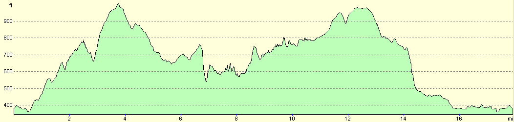
For more information on profiles, ascents and descents, see this page
Disclaimer
Please note that I take no responsibility for anything that may happen when following these directions. If you intend to follow this route, then please use the relevant maps and check the route out before you go out. As always when walking, use common sense and you should be fine.
If you find any information on any of these routes that is inaccurate, or you wish to add anything, then please email me.
All images on this site are © of the author. Any reproduction, retransmissions, or republication of all or part of any document found on this site is expressly prohibited, unless the author has explicitly granted its prior written consent to so reproduce, retransmit, or republish the material. All other rights reserved.
Although this site includes links providing convenient direct access to other Internet sites, I do not endorse, approve, certify or make warranties or representations as to the accuracy of the information on these sites.
And finally, enjoy your walking!
Nearby walks
| # | Title | Walk length (miles) |
|---|---|---|
| 11 | Stanton Moor | 2.9 |
| 12 | Darley Dale, Stanton Moor and Rowsley | 8.7 |
| 14 | Friden, Long Dale and Gratton Dale | 7.8 |
|
|

|