Walk #692: Stamford to Oakham
 |
 |
|
General Data
| Date Walked | 23/10/2005 |
| County | Cambridgeshire, Rutland, Northamptonshire |
| Start Location | Stamford |
| End Location | Oakham |
| Start time | 08.28 |
| End time | 14.29 |
| Distance | 16.8 miles |
| Description | This is a pleasant walk following the Hereward Way and other trails between Stamford and Oakham. |
| Pack | Today I carried my 30-litre Karrimor day sack, containing waterproofs, a water bottle, various odds and ends and a heavy hardback book. |
| Condition | I am pleased to say that the problem with my knees that has bedevilled my last few walk did not show up today; indeed, the only significant problem that I have had is with my toes, which were sore towards the end of the walk. I put this down to the fact that I have not done many walks recently, and my feet are not used to it. |
| Weather | Today was a cloudy day with some sunny periods; there was not much of a breeze, and although there were a few spits of drizzle in the air for a time this never amounted to much. It was a reasonably warm day, and all in all it could certainly have been much worse. |
| OS map | Explorer number 15 (Rutland Water) or Landranger number 141 (Kettering, Corby & surrounding area) |
 |
 |
|
 |
 |
|
Map of the walk
Maps courtesy of Google Maps. Route for indicative purposes only, and may have been plotted after the walk. Please let me have comments on what you think of this new format. For a detailed table of timings for this walk, please see the table file.
Notes
Before today I had not done a walk for three weeks or so, a result of the injury that I have had with my knees. Unfortunately they have not yet recovered, but despite this I knew that I had to get out and do a walk. On my sectional LE-JOG walk there are six or seven stages where I did not take photographs (all of which were walked in 1999 and early 2000), and I would like to re-do these stages so that I can get photographs. Hence this morning I found myself driving up the A1 to Stamford, ready to tackle once again the Stamford to Oakham walk that I first did in late 1999.
On the drive me right knee gave me some gip, and hence once I parked at Stamford station I was unsure whether I was going to actually do the walk. Stamford itself is a superb little town (some even say the prettiest stone -built town in Britain), and so as I strode around the car park, gingerly stretching my legs, I decided to spend a morning walking around the town if I could not walk. Fortunately this was not necessary, as I found that my knee was loosening up as I walked, and after a few minutes I packed my rucksack off and started walking through the car park towards the station building.
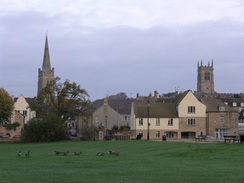
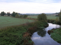
The first part of the walk took me across a bridge over the River Welland and onto the floodplains to the south of the town. From here the views towards the town were superb, with several church spires and a tower peering out above the rooftops. It was so nice I stopped to take a few photographs for a panorama, before heading off along the Hereward Way which is also the Jurassic Way at this point. Soon I passed a stone marker that marks the spot of the old Roman ford over the Welland, which was the point that the old Roman road to the north (the ancient equivalent of the A1) crossed the river. Apparently when a bridge in the location collapsed a new bridge was built further west, which is where Stamford now is.
A footbridge called Broadeng Bridge took me over the river, and I soon found myself passing under the A1 via a long subway. A short distance further on some wooden steps climbed up to a railway line, and once on the other side a little wooden causeway crossed a small marshy area before the path started climbing up a field. The views back from the climb were quite expansive, and this helped me speed my way up the climb to the church at Easton on the Hill. At the church I had a quick chat to a couple of locals waiting for church, before heading downhill through the village. On all sides of me were superb stone houses, built, like Stamford, from an outcrop of a narrow band of Cotswold stone that runs right across the country. This made the buildings almost glow in the sunshine, and the effect was immensely pleasing,
Once reaching the cross I started walking westwards out of the village along Ketton Drift, where the houses became marinade before fields enclosed me on both sides. Here I got my first views of the large cement works by Grange Top Quarry, and as the path dropped down to a road to cross the river for the final time and enter Rutland at Collyweston Bridge. A short distance I I entered the village of Aldgate, where the Jurassic Way was left behind and the Hereward Way continued on. Due to this change the way marking became much worse, and despite having walked this route before I found it hard to navigate as I took a footpath that crossed a grand bridge over a railway line to enter Ketton. This was another picturesque village, and there was a pretty bridge over a stream just before the equally picturesque church was reached.
The village cross sits in a wide junction between two roads, and from here it was not obvious where the Hereward Way went. Fortunately this did not delay me as a bit of dead reckoning took me onto the path that led across fields before reaching the track that heads uphill to the northwest. A short distance along this I came across a footpath diversion order from this July, which basically said that the path was being diverted further west to account for an extension to the adjacent Grange Top Quarry. A path between fences did indeed head off in the correct direction, and although there were no diversion signs I headed off uphill along this. After a short distance the paths headed off sharply to the left to head southwestwards, and so I was forced to cross an areas where the topsoil had been stripped off the ground as a precursor to the quarrying work.
I was unsure about whether the original route (which follows a track) was open, but I decided that it was better than making my way across this ground, I rejoined the track, and continued along it past a welcoming sign stating that walkers took precedence over the quarry trucks. To my left the quarrying was just about starting, and to my right I could see over the large quarry; the visible strata of the rocks in the cliffs fascinating me as I studied them. A solitary wind pump marked the end of the quarrying area, and I continued on across fields, skirting an area of woodland before reaching a road. Another footpath led on from here, heading northwards , crossing the A606 before reaching the village of Empingham.
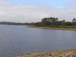
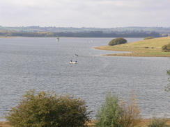
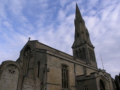
Empingham was another pretty village, and although it was not as picturesque as Ketton or Easton on the Hill I still enjoyed the walk through it. Once past the imposing church I followed the A606 for a short distance before descending along a footpath into a little valley; the path soon started rising through some woodland, which unceremoniously dumped me out at the base of the dam of Rutland Water. Here there was a trig pillar, but as I approached it I realised that bit was not an official Ordnance Survey pillar, but instead one that had been built to aid the construction of the dam. Instead of following the path towards the end of the dam I climbed straight up the face of the dam to the cycle path that runs across the top, and I was greeted with a superb view across the water, with the sun glinting majestically off the surface.
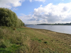
The cycle path took me on towards the northern end of the dam, and then on past a car park. There were occasional good views south over the lake, and these increased as it skirted around the edge of Whitwell Creek. There was a little boatyard here, and the water shined off the surface and reflected off the boats in a quite majestic manner. A little way beyond I reached the car park at Whitwell, where there is an adventure centre (teenagers were using a climbing frame high up in the air), and a café, which I nipped into. I could not resist a quick bite to eat, so I went in and got a nice bacon sandwich and a cup of hot chocolate I sat outside as I ate, watching people go to and fro through the car park.
I did not stay too long and I soon found myself heading westwards along the cycle path as it skirted the northern side of the reservoir. Unfortunately for much of the time the reservoir was out of view, particularly when the path went through trees in Barnsdale Wood. This improved slightly when it climbed up out of the trees to a raised car park, before dropping down to a road that itself led down to end at the water's edge. Before the reservoir was built the road obviously went down to one of the flooded villages, but from the end of it I got one of the best views that I had had over the reservoir. The sun was glinting off the surface, and I stopped for a few minutes to take a panoramic photograph of the view.
A short stretch of cycle path took me to the A606 road, which the Hereward Way uses almost all of the way into Oakham. This was a fairly boring walk, and although the cycle path is separated from the road the views over the reservoir were nowhere near as good as they could have been. When I had walked this route a few years ago the underside of my feet were aching a great deal by this stage, and it was with not a little satisfaction that me feet were fine today.
Eventually when the cycle path headed off eastwards at the western end of the reservoir, the way headed north away form the road, passing a stinking sewage works before passing through a new housing estate into the centre of Oakham. I enjoyed the walk through the town, and I took a little look around the outside of the church before making my way along the last few streets to the station, where I had about a quarter of an hour to wait for my train, during which I could sit down with a satisfaction that was not in the least dulled by the fact that I had done this walk before.
Directions
This walk starts off at the railway station in Stamford, and follows the Hereward Way for its entirety. From the station, heading north through some modern suburban housing to a little footbridge over the River Welland. Once across the bridge, do not continue straight on towards the town centre, but turn left and take a footpath that skirts the north bank of the river for a few hundred yards before heading southwestwards across the floodplain towards the green Broadeng footbridge over the river. From here, continue southwestwards along the obvious path, and when the river curves away to the right continue straight on to a pedestrian tunnel that leads under the A1(T).
Once under the A1(T) head southwestwards across a field for a short distance to some steps that lead up to a crossing over a railway line. On the other side, head down and cross a wooden causey over some marshy ground before the path starts to climb southwards uphill. As the hill becomes steeper it take more of a southwesterly course before ending at a track near the church in Easton on the Hill. At he track turn left and start following it as it passes to the left of the church and continues downhill until a crossroads is reached by the village cross.
Turn right and start following a road westwards out of Easton on the Hill; when the road ends a track, called Ketton Drift, continues onwards, with some good view available to the north. At the end of the track a footpath leads off half-left down the hill across a field, eventually ending at Ketton Road immediately to the east of Collyweston Bridge. Turn right and follow the road across the bridge, which crosses the River Welland once more, and continue along the road as it curves to the eight to enter the outskirts of the village of Geeston. When the road turns sharply to the left in the outskirts of the village continue straight on along the road for a few hundred yards until a footpath leads off to the left.
This footpath immediately crosses a railway line on a footbridge before continuing on and emerging out on a road beside a pretty bridge over a stream. Cross the footbridge by the bridge and continue along the road for a few yards past the church, and then turn right to follow a narrow footpath enclosed by high walls on either side. When the path emerges turn left to walk down towards the A1621 road, and then turn right up a residential road just before the larger Empingham Road. The road soon ends, and a footpath continues on northwestwards across a field before a track is reached.
Turn left and start following this track as it heads northwestwards uphill; as it passes the edge of Grange Top Quarry the route may change inn the future as the quarrying work is expanded, but on the other side it will regain the original route that slowly descends downhill past New Wood to meet a bend in a road. Leave the footpath and go onto the road, but immediately turn right and start heading north along another footpath with a hedge to the right. The footpath crosses the A606 Stamford Road before continuing on downhill. At the bottom of the hill the path crosses a stream, before passing a cottage and joining a road. Join this road and start following it uphill for a hundred yards or so, before turning left along another footpath.
This footpath emerges out onto a residential road, Willoughby Drive, in Empingham, which can be followed westwards through the village. Avoid the first turning to the right and take the second, and then immediately turn left to walk westwards down a short footpath, which joins Crocket Lane that ends at a T-junction with Church Street just above the church. Turn left and head downhill southwards past the church for a short distance until the road ends at the A606. Turn right and pass the village church, and when the road curves to the right turn left along another residential road, Nook Lane. After a few yards the road curves to the right, and a footpath continues on downhill across a field. At the bottom the path starts to climb uphill through an area of woodland, and once it emerges it continues on to cross a stile into a field below the dam of Rutland Water reservoir.
Once across the tile turn half-right to head uphill until it reaches the northwestern end of the dam. Here join the cycle path, and start following it as it heads westwards along the northern end of the reservoir. It soon passes a small car park, and a mile later it skirts around Whitwell Creek and passes a boatyard. After crossing another road it reaches another car park, where there is a climbing wall and a nice café. Pass the car park and continue on along the cycle path as it heads westwards, passing through Barnsdale Wood before joining a road and climbing up a hill to another car park. Continue along this road as it heads downhill , entering the woodland again for a short distance until it ends at a mini-roundabout with another road. Turn left and head down this road, and once it ends at the water edge turn right and follow another cycle path past Lodge Inlet until it reaches the A606 road.
From here the cycle path follows the A606 westwards for a couple of miles until a road junction is reached on the left. Here turn right and follow a track that passes a sewage works before becoming a footpath that heads uphill to Dog Kennel Cottage. Here turn left and follow a track as it heads westwards, soon entering a new housing development on the eastern edge of Oakham before passing older housing, where the road becomes Woodland View. When this road ends at Burley Road turn left and follow Burley Road southwestwards for a shirt distance until a junction is reached; here continue straight on along a surfaced footpath that crosses a little park. This soon turns slightly to the left to head south past the church, before turning right to end at Church Street. Cross this road, and then continue straight on along Northgate Street, which heads for a few hundred yards through the centre of Oakham before ending at the B668 road next to the railway line. At this road turn right to head northwards for a short distance until Oakham railway station is reached, where this walk ends.
Distances
| From | To | Distance (m) | Ascent (ft) | Descent (ft) |
|---|---|---|---|---|
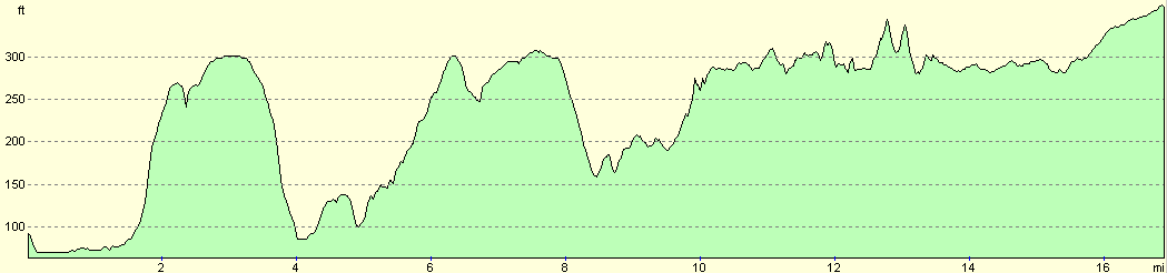
| Stamford station | Ketton | 5.0 | 341 | 328 |
| Ketton | Empingham | 4.2 | 348 | 262 |
| Empingham | Oakham station | 7.6 | 525 | 361 |
This makes a total distance of 16.8 miles, with 1214 feet of ascent and 951 feet of descent.
For more information on profiles, ascents and descents, see this page
Transport
There are regular train services running between Oakham and Stamford ralway stations, although they are more sporadic on Sundays. A single ticket cost me £5.30 for the journey.
Disclaimer
Please note that I take no responsibility for anything that may happen when following these directions. If you intend to follow this route, then please use the relevant maps and check the route out before you go out. As always when walking, use common sense and you should be fine.
If you find any information on any of these routes that is inaccurate, or you wish to add anything, then please email me.
All images on this site are © of the author. Any reproduction, retransmissions, or republication of all or part of any document found on this site is expressly prohibited, unless the author has explicitly granted its prior written consent to so reproduce, retransmit, or republish the material. All other rights reserved.
Although this site includes links providing convenient direct access to other Internet sites, I do not endorse, approve, certify or make warranties or representations as to the accuracy of the information on these sites.
And finally, enjoy your walking!
Nearby walks
| # | Title | Walk length (miles) |
|---|---|---|
| 56 | Peterborough to Stamford | 16.5 |
| 58 | Stamford to Oakham | 16.8 |
| 59 | Oakham to Melton Mowbray | 10.6 |
|
|

|