Walk #513: Melvaig to Poolewe
 |
 |
|
General Data
| Date Walked | 29/07/2003 |
| County | Highlands |
| Start Location | Melvaig |
| End Location | Poolewe |
| Start time | 08.53 |
| End time | 16.19 |
| Distance | 18.3 miles |
| Description | This was a highly enjoyable walk, with a lovely if rugged unpathed section sandwiched between two road walks. |
| Pack | Today I carried my 30-litre Karrimor HotRock rucksack, which was filled with my packed lunch, waterproof leggings, water bottle and a couple of spare shirts, together with the usual assortment of odds and ends. |
| Condition | I feel absolutely fine after this walk, and have no significant problems to report. My feet did not ache as much as they did yesterday, and my shoulder and neck were fine, for which I am thankful. |
| Weather | Today was quite a grey day, with very little sunshine to be seen all day. There were some periods of rain, but these were relatively light and drizzly until after I finished the walk, when the heavens opened. All in all it could have been much worse, and at least it was a warm day again. |
| OS map | Landranger number 19 (Gairloch & Ullapool, Loch Maree) |
 |
 |
|
 |
 |
|
Map of the walk
Maps courtesy of Google Maps. Route for indicative purposes only, and may have been plotted after the walk. Please let me have comments on what you think of this new format. For a detailed table of timings for this walk, please see the table file.
 |
Notes
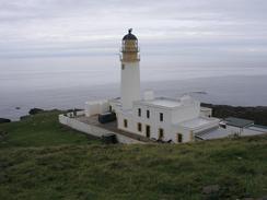
Sam walked with me for the first three miles of the walk northwards along the road to the lighthouse at Rubha Reidh. The walk was very nice, and we chatted about this and that as we walked along he road, which was mostly flat with only two small dips in it. Unfortunately the weather had closed in after last night, and this meant that the view were not as expansive - I could still make out Skye, but the Western Isles were lost in the clouds. Near the lighthouse we came across areas where peat had been cut - obviously the buildings at the lighthouse use peat to fuel their fires.
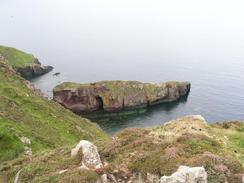
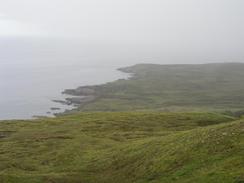
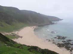
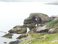
Rubha Reidh lighthouse itself is not the most impressive lighthouse that I have seen on this trip, and we gave it only a cursory examination before saying goodbye to Sam and heading off along the cliffs. On my way down to the lighthouse I saw a distinct path on the ground, so I went back up to this, only to discover that it soon vanished. I could see another path further towards the cliffs, so I went to this only to find that it led to the jetty below the lighthouse. From here, however, there was a path that led me eastwards for the first mile or so, past a beautiful natural arch nestling under the cliffs. The going was hard once the path finally disappeared (it may continue on and I just lost it - it did branch a lot and I may have taken the wrong one), but the walk was enjoyable and I eventually made my way down to the ruins above Camas Mor.
From the ruins at Camas Mor a path heads southeastwards to Midtown on the B8057, but I was keen to plod on along the moorland. The going was easier as the hills were more rounded and lower, even though it was rough at times, and I made some good time as I strolled along. At one point I met an elderly gent whom I chatted to for a few minutes. From his accent I guessed he was from South Wales, but it turned out that he was local, and for some reason had a Welsh accent - so much so that in the army he was known as Taffy, not Jock.
Sam was waiting for me in Mervan at the car park, and I dived in and took off my coat and top. This was dripping with moisture from sweat and the rain - I had been so hot that I had walked with my coat undone, and rain had got in to the front of my shirt. I changed my shirt and then ate my sandwiches, before walking with Sam to the top of the little hill to see the remains of the World War II gun positions. Loch Ewe looks tranquil nowadays, but during the first and second world wars it was massively busy. Convoys formed up to be sent across the Atlantic and to Russia (there is a lovely memorial to the Russian convoys on the hill), and in 1940 the entire fleet was moved to Loch Ewe when the Royal Oak was sunk in Scapa Flow. It is hard to imagine all of this nowadays, with the only industry to be seen in the loch being yet another ubiquitous salmon farm. The memorial to the Russian convoys was quite poignant, and well sited with the loch and the sea behind it.
After we went down the hill I saw a trig point at the top of an adjacent little hillock. This was not marked on the map but we went up to have a look at it anyway, and I was surprised to see a concrete cube of smaller and taller size than a normal Ordnance Survey trig point. On the top there was a marker, and it stated that it was an Admiralty trig point. I have never heard of these before, and this has got me very intrigued - I can only assume that it is to do with the gunnery positions in the area. Yet more research to be done once the walk is over!
The rest of the walk was a simple and straightforward plod down the B8057 road along the eastern bank of Loch Ewe. The walk would have been quite boring except for the scenery, which was not as dramatic as it had been over the last couple of days but was good enough anyway. Best of all the underside of my feet were not hurting me, which was a welcome relief after the pain of yesterday.
This campsite is quite busy, but it is also very good. The showers were some of the best that we have stayed at for some time, and I spent what could have been hours underneath one. I had not had a shower for two days, and after today, which had been very hot and sweaty, I was desperately in need of one. I came out refreshed and feeling like a new man, and this feeling was just heightened by the sight of the sun setting in a red sky below the hills at the western end of the loch. It was a magical sight, and I stood and looked at it for a couple of minutes before the midges started attacking me.
Directions
This walk starts off at a little car park at the end of the public road in Melvaig. Continue north from the end of the road along a public track, that heads northwards for a little over three miles until the lighthouse at Rubha Reidh is reached. From here follow the track until it ends at a jetty and then turn right to take an obvious track that leads eastwards up over the cliffs. The path soon disappears, and what follows is a rough and ready walk over moorland. Eventually the beach at Camas Mor can be seen below, and make your way along the cliffs past some ruins. From here the terrain is easier as it is less hilly, and you can just follow the rolling moorland eastwards to the car park at the end of the public road at Rubha nan Sasan.
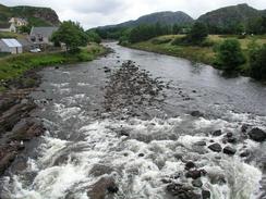
At the car park turn right and head southwards along the road, which eventually becomes the B8057 road. Continue along the road as it heads south along the western bank of Loch Ewe through the hamlets of Cove, Midtown, Naast and Boor, before eventually entering the village of Poolewe. When the B8057 road ends at a T-junction with the A832 road turn left and cross a bridge over the River ewe before reaching a caravan site on the right, where this walk ends.
Distances
| From | To | Distance (m) | Ascent (ft) | Descent (ft) |
|---|---|---|---|---|
| Melvaig | Rhuba Reidh Lighthouse | 3.2 | 325 | 404 |
| Rhuba Reidh Lighthouse | Rhuba nan Sasan car park | 6.2 | 1093 | 1129 |
| Rhuba nan Sasan car park | Poolewe | 8.9 | 764 | 820 |
This makes a total distance of 18.4 miles, with 2182 feet of ascent and 2353 feet of descent.
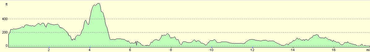
For more information on profiles, ascents and descents, see this page
Accommodation
We spent the night at the Inverewe Gardens Camping and Caravanning Club Site, Inverewe Gardens, Poolewe, Achnacheen, Highlands IV22 2LF, telephone (01445) 781249. This site was very clean and tidy, with some excellent showers and cost us thirteen pounds fifty-five pence for the night (although we got a five pound discount by using a discount voucher that we had).
Disclaimer
Please note that I take no responsibility for anything that may happen when following these directions. If you intend to follow this route, then please use the relevant maps and check the route out before you go out. As always when walking, use common sense and you should be fine.
If you find any information on any of these routes that is inaccurate, or you wish to add anything, then please email me.
All images on this site are © of the author. Any reproduction, retransmissions, or republication of all or part of any document found on this site is expressly prohibited, unless the author has explicitly granted its prior written consent to so reproduce, retransmit, or republish the material. All other rights reserved.
Although this site includes links providing convenient direct access to other Internet sites, I do not endorse, approve, certify or make warranties or representations as to the accuracy of the information on these sites.
And finally, enjoy your walking!
This walk was mentioned in the following routes:
| My walk around the coastline of Britain |
Nearby walks
| # | Title | Walk length (miles) |
|---|---|---|
| 511 | Alligin Shuas to Shieldaig | 19.5 |
| 512 | Shieldaig to Melvaig | 14.7 |
|
|

|