Walk #508: Tornapress to Applecross
 |
 |
|
General Data
| Date Walked | 24/07/2003 |
| County | Highlands |
| Start Location | Tornapress |
| End Location | Applecross |
| Start time | 09.45 |
| End time | 13.18 |
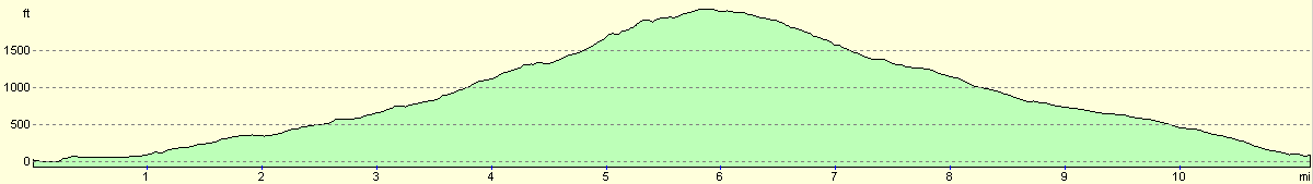
| Distance | 11.3 miles |
| Description | This was a very short road walk, but one that took me over the 2,053 feet high Bealach na Ba to the lovely village of Applecross. |
| Pack | Today I carried my 30-litre Karrimor HotRock rucksack, which was filled with my packed lunch, waterproof leggings, water bottle and a couple of spare shirts, together with the usual assortment of odds and ends. |
| Condition | I feel absolutely fine after this walk and have no problems to report, which is to be expected after such a short walk. My legs did not feel tired, which is a relief considering how they felt yesterday. |
| Weather | Today was a combination of sunshine and showers, with a cloud layer at about 1,200 feet. Due to the altitude that the road goes to I spent a considerable time in this cloud layer, and this was combined with quite a strong gusting wind at that altitude. Despite this it was quite a warm day, and I only felt cold when the wind gusted. |
| OS map | Landranger number 24 (Raasay & Applecross, Loch Torridon & Plockton) |
 |
 |
|
 |
 |
|
Map of the walk
Maps courtesy of Google Maps. Route for indicative purposes only, and may have been plotted after the walk. Please let me have comments on what you think of this new format. For a detailed table of timings for this walk, please see the table file.
 |
 |
|
Notes
Before I set off I knew that today would be a short day. Both Tom and Graham (two people who have completed and are doing the coastal walk this year respectively) had told me how nice Applecross is, and so I was looking forward to seeing the village. Eleven miles is usually far to short a walk for me to contemplate doing in a day unless here are exceptional circumstances, but being able to take an afternoon off will help me to recharge my batteries and relax a little - and then hopefully I will not have to take the day of that I was planning to do tomorrow.
Yesterday I had been considering walking along to the 896-metre summit of Beinn Bhan, a couple of miles away from the top of the Bealach na Ba. Unfortunately one sight of the weather this morning convinced me that this would not be worthwhile - in Lochcarron it as raining, with a very low cloud layer. Although I could have gone to the summit I would have had absolutely no views, and so I could not see the point of stumbling around moorland in the mist - I can always do plenty of that when I get back to Derbyshire!
Once Sam dropped me off back at Tornapress I quickly started the climb up the road. Although it is meant to be steep I found it very easy going, and I powered up the hillside. The road was busier than I had expected it to be, and I often had to divert onto the verge to let cars past. Most of the vehicles were cars, but there were occasional motorbikes and even a lorry or two and a motorhome. One of the lorries in particular came past me very slowly, obviously finding the ascent up the bealach very hard going with its full load of stone. It overtook me slowly, and the engine roared as it headed uphill. Once it was a few hundred metres beyond me there was a slackening of the gradient, and it started to accelerate up the hill. Near the top of the bealach there are a series of very impressive hairpin bends, which I can imagine are hairy in a large vehicle, and I again was thankful that Sam had decided to take the coast road around to Applecross.
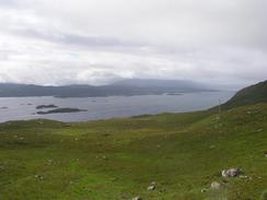
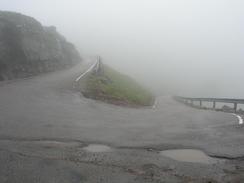
The cloud level was well below the summit, and I entered it knowing that from then on my views, which had previously been quite expansive, were to be severely limited. It really was a shame, as I can imagine that the sides of this absolutely classic U-shaped glaciated valley would be spectacular. I eventually negotiated the hairpins and reached the top, which is marked by a viewpoint marker and a car park. The wind was gusting as it was a fairly exposed location, blowing the cloud and making my coat wet. As I read the marker some bikers arrived and we had a quick chat before I jogged off downhill to warm up. The rest of the descent was simple and straightforward, and I was pleased to see I kept up 3.2 miles per hour over the entire day's walk - not bad considering it included a 600-metre climb.
Just before I got to the centre of the village of Applecross I saw a sign for the Applecross campsite. Not wanting to have to divert down into the village and then come back uphill I went straight to the campsite, and saw Mervan sitting waiting for me. Unfortunately Sam was not there, so I sat down to wait for her. I was extremely tempted to continue on and walk down the road to Toscaig and back; this would have extended today's walk by about eight miles. Although this was tempting (especially as the weather seemed to be improving), I decided to sit down and eat my lunch. Whilst I did this I put the computer on and started writing up the walk so far, and before I knew it I had spent an hour and a half at the computer and Sam was still not back.
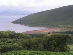
Applecross and the adjacent communities were known as being some of the most isolated on the mainland, as the road up Bealach na Ba was often closed during the winter (some years only for a few weeks, and others for a couple of months). When the road was closed they had to rely on a boat coming over from the Kyle of Lochalsh, but in bad weather they could not do that either. The situation was much improved on the 17th September 1976, when the new coast road was opened. This followed the route of the old postman's route, and is a far better, longer and lower road that the Pass of the Cattle. Having seen the weather up there on a July day, I can imagine how bad it can get in the depths of winter.
Not wanting to waste and entire nice afternoon in front of the computer, I decided to go down for a walk to see if I could find Sam. She was not to be found in the post office, so I walked to the Applecross Inn to see if she was there. She was not, but I used the opportunity to have a quick pint, which I quickly sunk down. Leaving the inn I started the climb uphill to the campsite once again, and on the way I met her coming down the hill. It turns out that she had been in a cafe about a mile north of the village, and so we progressed back down to the inn for another drink. By this time I had totally rejected the possibility of extending the walk, a decision that I was totally at home with. I still had quite a lot of work to do in Mervan, so we went back to the campsite and I spent the rest of the afternoon typing up today's walk and spending time with Sam.
This evening we went to the Applecross Inn to treat ourselves to a meal - Tom and Graham had both told us how good the company and food was there (indeed it has won awards as being the best seafood pub in Scotland), and so we decided to try it. It was not too expensive, and we both had lovely meals - Sam had King Scallops, and I had Venison sausages. When they heard what I was dong, the owner organised a raffle for us, which raised fifty-one pounds for us, which was increased when we did a collection afterwards. This was extremely kind of the owner and staff of the pub, and we would like to than them for their kindness. due to all this I went to bed in a slightly more inebriated state and far later than I normally go to bed, which will probably lead to me suffering in the morning!
Looking at my itinerary, I should reach Cape Wrath a fortnight today. This will literally and metaphorically be a high point of the walk; the place where I leave the west coast and join the north coast. I will have been on the west coast for well over six months, and it makes the eight or nine days that I will be spending on the north coast seem positively short! On a long trip like this thinking more than a day or two head can be devastating for my morale, but I really cannot help but think about Sandwood Bay and Cape Wrath now that they are so near.
Directions
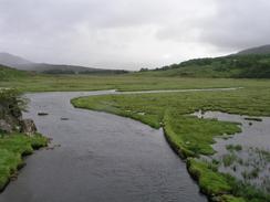
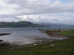
This walk starts off at the road junction on the A896 road at Tornapress, and the directions are very simple. Simply keep to the minor road as it skirts the northern and western side of the head of Loch Kishorn. It then climbs up to the west to over 600 metres in height, passing the side of Coire na Ba and up Bealach na Ba before reaching a car park and viewpoint at the summit. From there it is a simple matter of descending down the road westwards into Applecross. Just before the village is reached there is a tight hairpin bend; this walk ends at a campsite that is straight on at the bend, next to a tearoom and bakery.
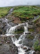
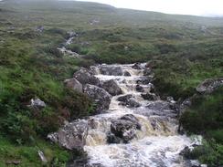
There is also an alternative, more coastal route that you could take if you wanted to avoid the high ground or stick more religiously to the coast. Note that I have not walked this, but it certainly looks possible from the other side of the loch. Walk along the first part of this walk along the west bank of Loch Kishorn, but instead of following the road as it climbs uphill to the right take a road that leads off to the left and descends to meet the side of the loch. The road becomes a track and follows the side of the loch, crossing over Russel Burn before it ends at an old oilrig construction site. From here you would have to follow the coast southwestwards for three or four miles until you reach the old settlement at Airigh-drishaig. From here a path, which is apparently waymarked, leads westwards over the hills until it meets the end of the road at Toscaig. Here turn right and follow the road northwards for four miles to Applecross village.
Distances
| From | To | Distance (m) | Ascent (ft) | Descent (ft) |
|---|---|---|---|---|
| Tornapress | Top of Bealach na Ba | 5.9 | 2215 | 190 |
| Top of Bealach na Ba | Applecross campsite | 5.4 | 75 | 2034 |
This makes a total distance of 11.3 miles, with 2290 feet of ascent and 2224 feet of descent.
For more information on profiles, ascents and descents, see this page
Accommodation
We spent the night at the Applecross camp site, Applecross, Strathcarron, Wester Ross, Highlands IV54 8ND. This was a nice campsite, which was well situated for the local area and sops - it even has a bakery and tearoom on site. The showers were nice and hot, and everyone staying there was even friendly. Even better, the site should have cost us thirteen pounds fifty pence, but they gave it to us for eight pounds. They can be contacted on (01520) 744268 or (01520) 7442874, or by email at applecross@sol.co.uk, and they have a website at http://www.idb.co.uk/applex.htm.
Disclaimer
Please note that I take no responsibility for anything that may happen when following these directions. If you intend to follow this route, then please use the relevant maps and check the route out before you go out. As always when walking, use common sense and you should be fine.
If you find any information on any of these routes that is inaccurate, or you wish to add anything, then please email me.
All images on this site are © of the author. Any reproduction, retransmissions, or republication of all or part of any document found on this site is expressly prohibited, unless the author has explicitly granted its prior written consent to so reproduce, retransmit, or republish the material. All other rights reserved.
Although this site includes links providing convenient direct access to other Internet sites, I do not endorse, approve, certify or make warranties or representations as to the accuracy of the information on these sites.
And finally, enjoy your walking!
This walk was mentioned in the following routes:
| My walk around the coastline of Britain |
Nearby walks
| # | Title | Walk length (miles) |
|---|---|---|
| 506 | Kyle of Lochalsh to Strathcarron | 19.7 |
| 507 | Strathcarron to Tornapress | 15.8 |
|
|

|