Walk #501: Tarbet to Inverie
 |
 |
|
General Data
| Date Walked | 17/07/2003 |
| County | Highlands |
| Start Location | Tarbet |
| End Location | Inverie |
| Start time | 07.20 |
| End time | 22.02 |
| Distance | 17.3 miles |
| Description | This was a long and difficult day's walk around Loch Nevis to Inverie, and is only to be attempted by fit people. |
| Pack | Today I carried my seventy-litre Craghoppers rucksack with full camping gear, except I carried a bivvy bag instead of a tent. |
| Condition | I am exceedingly tired after this walk, and the main problem physically is my left shoulder, which feels as though it is bruised. The fatigue is very much predominant, however. |
| Weather | Today was an exceedingly warm day, with the sun shining all day and only a few clouds in the sky. There was a bit of a breeze to try to cool me down, but this was infrequent enough not to be of any real use. |
| OS map | Landranger number 33 (Loch Alsh, Glen Shiel & Loch Hourn) |
 |
 |
|
 |
 |
|
Map of the walk
Maps courtesy of Google Maps. Route for indicative purposes only, and may have been plotted after the walk. Please let me have comments on what you think of this new format. For a detailed table of timings for this walk, please see the table file.
 |
 |
|
 |
Notes
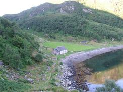
I woke up early this morning, which was probably not a good thing after the late night last night. It was unavoidable, however, as the workmen got up before seven so that they could walk over to the castle. I decided against having any breakfast, as I was not hungry, and packed up my bag and was on the road by seven twenty, which was one of the earliest starts of the walk so far. My main idea as to miss the hottest part of the day, or at least get as many of the difficult miles done as possible before it got too hot. The initial stretch of the path was very good going, and I reached the far at Kylesmorar in good time. I was amazed to find someone about, and it turns out that they need so many builders on the job that one man is bunking in the farmstead and has to travel to work by boat each day!
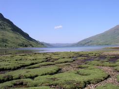
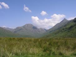
After Kylesmorar the coast became much rougher, and progress consequently became much slower and ponderous as I tries to find my way around the numerous headlands. A little over halfway through this I was amazed to find a man coming towards me, and he seemed to be as surprised to see me as I was to see him, as he told me that I was the first person that he had seen for two day! He was doing a walk from Montrose to Morar, and was hence on the last leg of his trip. This made me feel slightly envious, as I knew that I still have a long way to go before I finish my epic trip. Unit I got near to Sourlies the coast continued to be extremely rough going, and it was impossible to keep a decent pace up. At one stage I found myself balancing with both hands and one foot on a ledge with a sheer thirty foot drop beneath me onto the rocks below, and my rucksack hanging over the drop. It is on those sorts of occasions that you realise that one slip could be severely dangerous. The problem on that occasion was that I could no see a better route, and I could see a rough track on the other side and on this one-foot (literally!) wide ledge. Of all the parts of the walk that I planned this was the one that I was most wary of, and so it makes me feel extremely good that I managed it so well (I would never call it an easy walk!). The views on the walk up and down the loch were superb in the sunshine, but even these are not enough to make me say that I would do it again - I think that I will stick to the Glendessary route to Sourlies in the future!
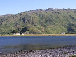
Before I set out this morning I had told myself that if I got to Sourlies before midday I would have a long rest and then seriously consider going on to Inverie. When I finally got to the bothy at Sourlies I was tired, but aside from that I felt fine, and so I decided that I would set off again after an hours rest. The bothy was full of kit anyway, so I doubt that I could have found anywhere to sleep. Outside the bothy there were four German scouts who had camped there overnight, and I chatted to them for a while before retiring into the bothy to get out of the sun. I could not be bothered cooking and I did not want any coffee which would dehydrate me further, so I just ate half a pack of mixed nuts and raisins, which gave me some energy with which to face the rest of the trip. Despite my tiredness I was confident that I could make Inverie - I had all afternoon in which to do it, and at least the weather was good.
The initial stretch of the walk to Inverie as far as the ruined buildings at Carnoch was very nice, and I enjoyed the stroll in the warm sunshine. The bridge over the River Carnoch was an interesting affair, and it wobbled quite alarmingly as I crossed - the sound of the wooden boards creaking also added a frisson of excitement. Unfortunately as soon as I it the ascent I knew that I was in trouble, and that the rest of the walk was going to be far from easy. I soon passed the scouts above Carnoch, who were swimming in a stream, and they kindly refilled my water bottle for me (needless to say from above where they were swimming!)
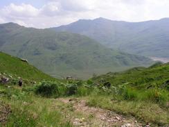
The rest of the ascent took ages, and I had to stop occasionally to have a breather. I also found myself doing something that I have never done before - counting the feet to the top. When I finally reached the top of the bealach I should rightly have been elated by the views down towards Inverie, but I was just to knackered.
As I was joining the end of the public road a short distance to the east of Inverie I saw Sam walking along a track in the opposite direction. This was an amazing coincidence, as I would have found it very hard to locate the tent if I had not found her first. It was superb timing in another way - she was getting ready to cook, and so if I had been any later I would have missed dinner and I would have had to eat at the pub. I was totally shattered by the time that I met her, and the last few yards to the campsite seemed to take an eternity. When we got there I took my rucksack off removed my roll mat and lay motionless for half an hour, more shattered than I have been on this trip as far as I recall. Sam cooked a marvellous beef curry, and after this I started to feel a little more alive.
Later on in the evening we walked to the Old Forge Inn in Inverie for a quick drink, and to chat to some of the other people from the campsite who had gone over there. The Inn is the most remote one on the British Mainland, and all provisions have to be bought in by boat. I was too knackered to join in the conversations, and we soon set off once again, seeing an otter playing in the sea on the way back.
Directions
This walk starts off at the Old Church Bunkhouse in Tarbet. Leave the bunkhouse and take a distinct path that heads uphill along the eastern side of Tarbet Bay. The path rises up over Druim Chuilinn and then slowly descends as it heads eastwards for about a kilometre until it reaches the farm at Kylesmorar. From here to the eastern end of Loch Nevis at Sourlies bothy I will not describe a route, as there is no path; you have to walk along some wild and rugged coastline. I tried to keep as low as possible, although in most places the foreshore could not be walked along and I often had to climb uphill to get over sea cliffs. The going is very rough and remote, and it should not be attempted by anyone who is not an experienced walker.
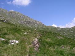
From Sourlies bothy the route follows a path northwestwards past a little headland; at low tide you can walk along the foreshore around this but if the tide is high you will have to clamber over it. On the other side of the headland head north along a boggy area for about a kilometre as it joins the bank of the River Carnoch. Just before the ruined buildings at Carnoch are reached a rickety bridge crosses the river. A distinct path continues on above the buildings, and then starts a seemingly endless series of zigzags steeply uphill northwestwards before it eventually reaches Mam Meadail at about six hundred metres high.
On the other side the path is very obvious as it descends at a gentler pace down Gleann Meadail. After a few miles near Torran Tuirc the path crosses the river and climbs uphill for a short distance, before continuing on for another mile and reaching a bridge over the Inverie River. Shortly after this the track ends at a T-junction. Turn left along another track that passes below a large monument before heading northwestwards before entering a small area of woodland and descending steeply to reach the end of a pubic road near Inverie House. There is a campsite and bunkhouse down a track to the left, and if you turn to the right you can walk for a little under a mile until you reach Inverie, where there is an Inn and a B&B.
Distances
| From | To | Distance (m) | Ascent (ft) | Descent (ft) |
|---|---|---|---|---|
| Tarbet | Sourlies | 6.7 | 1152 | 1155 |
| Sourlies | Inverie campsite | 10.6 | 2533 | 2543 |
This makes a total distance of 17.3 miles, with 3685 feet of ascent and 3698 feet of descent.
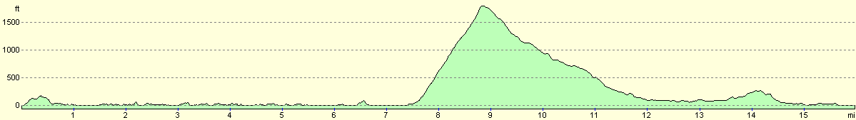
For more information on profiles, ascents and descents, see this page
Accommodation
We spent the night at the only campsite at Inverie, which is free and is a mile east of the village, right next to the sea and near Inverie House. There were some facilities in a nearby hostel cum bunkhouse that we could use, such as a water tap, toilets and even a shower.
Disclaimer
Please note that I take no responsibility for anything that may happen when following these directions. If you intend to follow this route, then please use the relevant maps and check the route out before you go out. As always when walking, use common sense and you should be fine.
If you find any information on any of these routes that is inaccurate, or you wish to add anything, then please email me.
All images on this site are © of the author. Any reproduction, retransmissions, or republication of all or part of any document found on this site is expressly prohibited, unless the author has explicitly granted its prior written consent to so reproduce, retransmit, or republish the material. All other rights reserved.
Although this site includes links providing convenient direct access to other Internet sites, I do not endorse, approve, certify or make warranties or representations as to the accuracy of the information on these sites.
And finally, enjoy your walking!
This walk was mentioned in the following routes:
| My walk around the coastline of Britain |
Nearby walks
| # | Title | Walk length (miles) |
|---|---|---|
| 186 | Glenfinnan to A'Chuil Bothy | 12.8 |
| 187 | A'Chuil to Gairlochy | 22.9 |
| 500 | Arisaig to Tarbet | 19.5 |
|
|

|