Walk #482: Kilberry to Strone
 |
 |
|
General Data
| Date Walked | 26/06/2003 |
| County | Strathclyde |
| Start Location | Kilberry |
| End Location | Strone |
| Start time | 06.59 |
| End time | 16.50 |
| Distance | 30.1 miles |
| Description | This was a very long walk that was made worthwhile by some brilliant views over the various lochs. |
| Pack | Today I carried my 30-litre Karrimor HotRock rucksack, which was filled with my packed lunch, waterproof leggings, water bottle and a couple of spare shirts, together with the usual assortment of odds and ends. |
| Condition | I feel very fatigued after this long walk, but otherwise I feel fine. For the first time since I injured it my neck gave me no troubles, despite wearing my 30-litre rucksack for the first time in a couple of days. |
| Weather | I was expecting today to be very hot and sunny, and although it was sunny for much of the day there was a cooling wind and the sky was generally hazy. For these reasons it was not as hot as it was yesterday afternoon, and therefore it was a much nicer walking day. |
| OS map | Landranger number 62 (North Kintyre & Tarbert) and Landranger number 55 (Lochgilphead & Loch Awe) |
 |
 |
|
 |
 |
|
Map of the walk
Maps courtesy of Google Maps. Route for indicative purposes only, and may have been plotted after the walk. Please let me have comments on what you think of this new format. For a detailed table of timings for this walk, please see the table file.
 |
 |
|
 |
 |
|
Notes
This was by far the longest walk that I have done on the trip so far, and is the first time for many years that I have walked thirty miles in a day. It is certainly not something that I would want to do every day, but it is very nice to know that I can do it if I need to. I am also pleased by the fact that I managed to keep up 3.3 miles an hour (excluding the two breaks), which is not a bad pace.
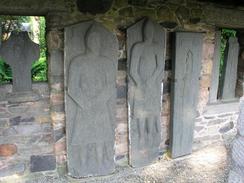
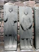
Sam had a long drive to Glasgow and back to make today, to visit a Fiat dealer who could fix an electric window in Mervan. for this reason I started the walk very early, and was on the road a couple of minutes before seven. I had heard that there were some very nice carved graveslabs a short distance away at Kilberry Castle, so I walked down the drive to have a look at them. They were very nice, nut not as impressive as the ones that I saw at Saddell last week, and nowhere near as good as he ones that I saw later on today. I walked back to the road, and then headed north for what seemed like an eternity.
I stopped for a short rest by the attractive little church at Achahoish, and then set off again. I stopped to have a little look around the ruined chapel - now nearly totally covered in a green layer of ivy - and St Columba's Cave. The latter is quite an impressive cavern in the rocks, and is very secluded, especially as the path was overgrown with brambles that tried to gash my bare legs. It was actually quite a romantic setting, and I stood around letting the atmosphere sink in.
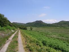
A little further down the road at Ellary I joined a track that headed high up onto the hills. The track was lovely after all the road walking that I have done over the last few days, and although there were no views over the lochs from this high ground they were good enough anyway. The track eventually reached Balimore, and I started to head northwards once again towards Kilmory. The chapel there is ruined, and on a sudden impulse I decided to go down and look at it. I opened the door and was greeted with a superb sight - the building was filled with over thirty carved graveslabs, some of which were in very good condition. I walked around and examined them for ten minutes, before sitting down on a bench and eating my lunch. It was a fairly unique place to have lunch, and I kept on getting up to have another look around. From outside the chapel appears to be roofless, but a new roof has been placed low down, so it is invisible from outside.
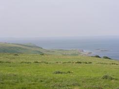
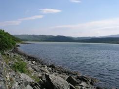
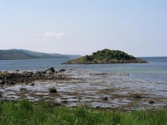
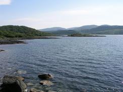
The rest of he walk was along the road northeastwards up Loch Sween, a long plod that was made more than bearable by the superb views over the loch and out to sea. As I went on I started to get increasingly fatigued, and although this made the walk slightly less enjoyable the scenery kept me going. The sun was shining off the surface of the loch, and the water was twinkling in a beautiful way - I can only wish that the whole trip had such scenery.
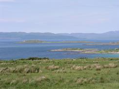
Sam drove down the road and met me about three miles south of Achnamara, and I could easily have ended the walk then. I still felt quite fit, however, and I fancied reaching thirty miles today. I therefore arranged to meet her a few miles up the road, and by the time I reached her to the north of the village I had completed a little over thirty miles, which pleased me immensely. I jumped into Mervan and we then drove up the road to the nearest village of Crinan for the night.
One thing confused me about this walk - in my schedule I had the walk as far as Achnamara as being 19.7, but on my GPS it was measured as nearer 28. This concerned me slightly, and this evening I remeasured the route on the map, getting a mileage of 27, much nearer the GPS reading. It turns out that I had measured one of the smaller stages incorrectly, and this has made the significant distance. Afterwards I remeasured tomorrow's walk, and as I have decided to change my route (so that I can visit Crinan), and this has added more than ten miles onto my total. I am not bothered about this, as I want to extend the walk and the route through the woodland to Tayvallich and then north to Crinan looks to be a lovely walk.
 |
Directions
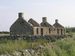
This walk starts off at the KIlberry Inn in Kilberry. Leave the pub and turn right to head northwards along the road. After a couple of hundred yards a track leads off to the left and leads down to the Kilberry Stones; these are well worth a look and if you do then turn to the road and head north. Near Kilmaluaig House the road meets the side of Loch Caolisport and turns to head northeastwards. In total walk along the road for about ten and a half miles from Kilberry until a road junction is reached in Achahoish. Pass the church and continue along the road through Lochead, where it turns to head southwestwards along the northern side of the loch. The road passes the ruins of a chapel, behind that is St Columba's Cave.
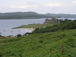
Continue along the road until it ends at Ellary, and then follow a private road that curves around the estate. When this heads through a gate towards a house turn right up another track that heads through a gate before turning sharply to the right. The track has two narrow strips of tarmac where the car wheels go, and is very easy to follow as it winds its way up to Loch Meadhonach. It then turns to head southwestwards for a couple of miles before rejoining the public road at Balimore. Join the road and follow it as it curves to head northwards and then northeastwards, passing through Kilmory and continuing on to pass Castle Sween. The road is very long, but it eventually passes through Kilmichael of Inverlussa before reaching Achnamara. Beyond Achnamara the road goes through a series of hairpin bends, and this walk ends shortly before it reaches Strone after these bends.
Distances
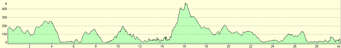
| From | To | Distance (m) | Ascent (ft) | Descent (ft) |
|---|---|---|---|---|
| Kilberry | Achahoish | 11.0 | 994 | 1073 |
| Achahoish | Kilmory | 8.1 | 1010 | 1004 |
| Kilmory | Strone | 11.0 | 801 | 850 |
This makes a total distance of 30.1 miles, with 2805 feet of ascent and 2927 feet of descent.
For more information on profiles, ascents and descents, see this page
Accommodation
There was not really anywhere convenient to park where I finished today's walk, so we drove into Crinan and parked at the car park by the sea lock, right beside the 'Vital Spark'.
Disclaimer
Please note that I take no responsibility for anything that may happen when following these directions. If you intend to follow this route, then please use the relevant maps and check the route out before you go out. As always when walking, use common sense and you should be fine.
If you find any information on any of these routes that is inaccurate, or you wish to add anything, then please email me.
All images on this site are © of the author. Any reproduction, retransmissions, or republication of all or part of any document found on this site is expressly prohibited, unless the author has explicitly granted its prior written consent to so reproduce, retransmit, or republish the material. All other rights reserved.
Although this site includes links providing convenient direct access to other Internet sites, I do not endorse, approve, certify or make warranties or representations as to the accuracy of the information on these sites.
And finally, enjoy your walking!
This walk was mentioned in the following routes:
| My walk around the coastline of Britain |
Nearby walks
| # | Title | Walk length (miles) |
|---|---|---|
| 471 | Furnace to Lochgilphead | 17.4 |
| 472 | Lochgilphead to Tarbert | 13.9 |
| 480 | Tangy Lodge to Clachan | 20.7 |
|
|

|