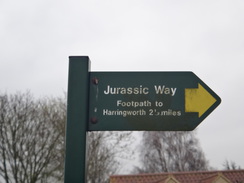
Walk #991: Jurassic Way: A linear walk between Barrowden and Rockingham and return
 |
 |
|
General Data
| Date Walked | 13/04/2018 |
| County | Northamptonshire, Rutland |
| Start Location | Barrowden |
| End Location | Barrowden |
| Start time | 06.25 |
| End time | 13.36 |
| Distance | 19.4 miles |
| Description | This should have been a pleasant walk following the Jurassic Way between Barrowden and Rockingham and back, but it was sadly let down by some fairly awful conditions underfoot, the most consistently bad I can remember from any walk. |
| Pack | Today I carried my 30-litre Karrimor rucksack, filled with water, my spare waterproofs, a book and other odds and ends. |
| Condition | I am fairly tired after this walk, but have no serious problems. |
| Weather | The day was generally cloudy with no sign of the sun, and the skies were thoroughly hazy. It rained during the journey to Barrowden, but remained dry through the walk. |
| OS map | Landranger number 141 (Kettering, Corby & surrounding area) |
 |
 |
|
Map of the walk
Maps courtesy of Google Maps. Route for indicative purposes only, and may have been plotted after the walk. Please let me have comments on what you think of this new format. For a detailed table of timings for this walk, please see the table file.
 |
 |
|
Notes
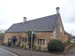
After another week of wet weather, it was time to put on my boots and do another walk. I had two choices: to continue the Jurassic Way east from Rockingham in a there-and-back stroll, or to do the section west of where I joined it on the last walk. In the end I chose the former, and set off early for the drive down to the little village of Barrowden. I could not find a suitable place to park, and eventually I settled on a wide residential street with a few parked cars. It had rained on the entire drive, and the forecast was for light rain until eight. Fortunately, it stopped raining as I parked up, and I set off in my fleece, slightly fearful of yet more rain.
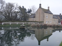
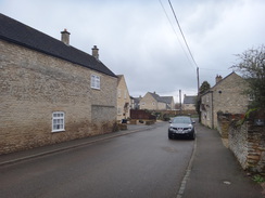
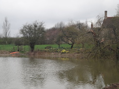
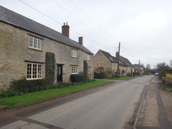
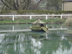
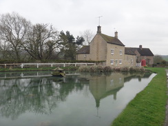
A path took me down to the centre of the village, which is very pretty: the pond was attractive despite the dismal skies, and the yellow stonework of the houses glistened with moisture. A plaque on a house mentioned Thomas Cook, the travel pioneer, but it was too high on the wall for me to read (it turns out he married a local woman in the village in 1829, many years before he founded the company). The trail followed a road out of the village, after which it diverted through a field containing bleating lambs that followed me to the next stile, and on to reach the edge of the old Peterborough to Rugby railway line, which I had crossed twice on the last walk.
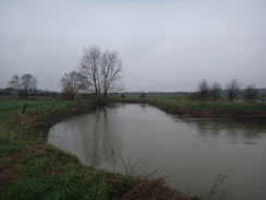
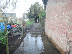
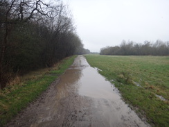
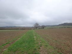
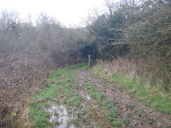
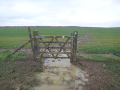
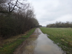
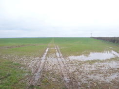
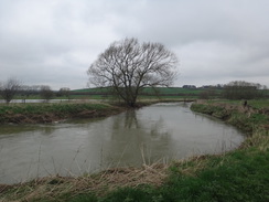
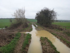
The edge of the field marked my first proper encounter with something that would plague the rest of my day: mud. The ground everywhere was well and truly waterlogged after the months of snow and heavy rain, and the field was like a morass. Things got better when the trail crossed the old railway line at a filled-in cutting to enter a field, but even this was boggy in places. Down below, the River Welland had not burst its banks, but some surrounding fields were flooded, either from previous flooding or just from the sheer amount of rain.
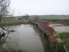
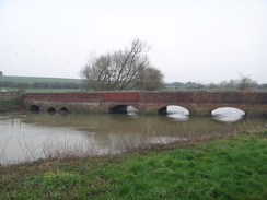
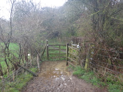
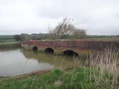
A strange stile embedded in a field gate led out onto a track covered in puddles, and this descended to a red-brick bridge over the river. A sign on one side proudly stated that you were in Rutland, and seemed utterly overlarge for its location on this quiet byway, and on the Northamptonshire side was a sign stating the track was restricted to traffic for much of the year. The bridge itself was a curiously attractive affair; squat and low to the water, its red brick and triangular stone breakwaters made it impossible for me to tell its age: it might be a hundred years old or five hundred. It turns out that it is probably 14th Century in date, and was widened in 1793, with the low parapets much newer.
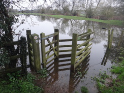
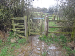
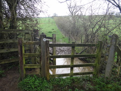
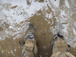
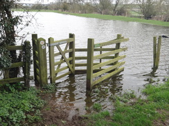
The trail cuts directly across the fields on the southern side of the river. The official route was very waterlogged, and so I took the riverside path, which was probably much more scenic. The river looked very full, and some trees sat sadly in the rushing water, their leafless branches pointing to the sky. The next problem came as I neared the village of Harringworth: a clappergate leading into a field was flooded. I dipped my boot in, but it got dangerously near the top of my gaiters. Fortunately the fence nearby was easy to climb over (although the rabbit holes underneath it were nearly filled to the brim with water), and I headed on into Harringworth.
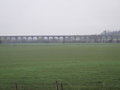
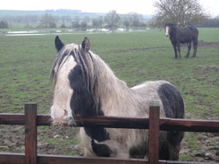
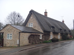
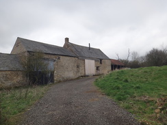
This pretty village is dominated by the Welland Viaduct, a magnificent 82-arch viaduct built by the Midland Railway in 1866-8 to carry their Kettering to Oakham line. Even though it runs close to the village, I could not get a good view of it due to the slight mist in the air. Instead I traipsed past horses who seemed utterly fed up at being in a waterlogged field (and who looked waterlogged themselves), and joined a road. There are lots of pretty stone houses in the village, many of which are thatched, and soon the pavement diverted away from the road uphill to the hamlet of Shotley.
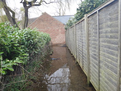
Here I came across more flooding, and unusually it was on a hillside. The trail leaves the hamlet by a path that squeezes between gardens, and the path, filled up with what looked like builders' rubble, was flooded. There was no obvious alternative route, so I waded through. The deepest sections were higher than my boot, but fortunately there were areas where thee rubble made it shallower, and I got through without getting my feet wet. After this the trail climbed steeply uphill out of the village, and the field was utterly waterlogged. It was a struggle to make it up, and my walking poles proved invaluable.
Thankfully things got better as the gradient slackened near the top and i joined a road beside a low brick wall in a field. There was a similar wall on the other side of the road; I went for a look, and was surprised to see that they were bridge parapets, and the remains of an old cutting stretched away into the distance. These are the remains of just a small part of the rail system that supported the old ironworkings for Corby steelworks - though I was surprised to see virgin-looking fields on the other side of the bridge - the cutting and workings on that side had obviously been filled in.
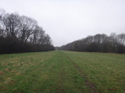
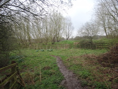
The trail did not stay with the old railway, and instead cut across fields towards a farm at Harringworth Lodge. It joined a rough track and headed past a lake, before following the edge of some woodland. In places the track was flooded from one side to the other, and the route past along the grass was decidedly squelchy. The track eventually diverted away, and a bridleway continued on across grass.
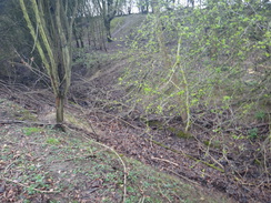
A steep-sided cutting became visible through trees on the right; this looked as though it may have been part of the old ironworking railway system, although it was very narrow at the bottom and had the remains of a concrete culvert at its base. Yet it also seemed to make a very odd drainage channel. The answer came at home, when a search of the Internet showed that it was indeed the remains of part of the industrial railway system, most traces of which have long gone.
More squelchy fields followed, and by the time I reached Gretton my trousers were absolutely filthy. On the map the trail takes a looping route through the village, although the waymarkers on the ground showed a more direct route along a road. I followed the waymarkers through the pretty village, but by this point I was so muddy that I cared little for prettiness and just wanted to finish the walk.
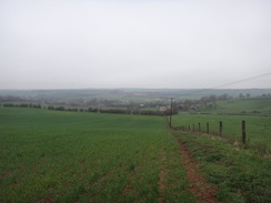
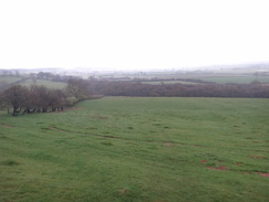
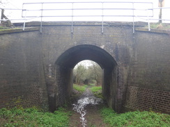
In good weather the views from the path leaving Gretton would have been superb, but the day was not clear and instead I just got a distant wet haze. I could see bands of rain falling to the north, grey streaks falling to the ground, and soon I was descending a steep hillside to reach the Corby to Oakham railway line, which passes overhead on a high embankment on its way to the Welland Viaduct. A clappergate at the bottom of the slope was flooded, but I waded through and continued on to reach a bridge under the railway.
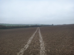
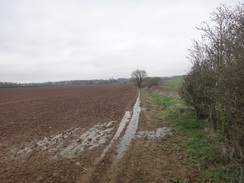
The next two miles were far from pleasant. The trail takes a path across many fields along a route that I guess it was once a route between Gretton and Rockingham churches. In fine weather it would have been a pleasant stroll, but even though it was not raining, the squelchy and boggy conditions underfoot made it an ordeal. There was another flooded clappergate, this one with the added complication of overhanging brambles, but eventually I made it to Rockingham, passing a Land Rover garage before reaching the main road in the village. I crossed the road to reach the pavement I had followed during the previous outing, and then started back.
The return journey was more of the same: mud, bog and puddles. However I found myself walking faster, as if there was now little point in avoiding getting muddy. The skies had also cleared slightly, giving me better (though far from perfect) views, especially of the Welland Viaduct. There were no shops on the way, and I had forgotten my sandwiches at home, so I munched on a couple of emergency chocolate bars and squelched on.
I eventually arrived back at Barrowden, which was almost as quiescent in the early afternoon as it had been in the early morning. I had a bit of trouble finding the street in which I had parked my car, but this meant I got to stroll around the village a little - hardly a bad thing.
Having given up on the Nene Way for a while due to flooding, it's a shame that my chosen alternative is also facing problems. The forecast for the next fortnight is for warm, dry weather, which should give the paths time to recover. In the meantime, I might abandon the Jurassic Way as well, and instead move onto a couple of firmer walks.
 |
 |
|
Directions
This walk starts off at the Exeter Arms in Barrowden at SK94640009. Leave the Exeter Arms and turn right for a few metres to join Main Street, and follow this westwards out of the village. After about 400 metres, a road junction is reached. Turn left down Seaton Road, and then after about fifty metres, turn left past double gates to join a surfaced access driveway that leads to Durant Farm. After forty metres, turn right across a stile to enter a field. Head diagonally across the field, aiming for a gap in a hedge ahead. Go through a stile in the hedge to enter a second field; head diagonally across this field, aiming for a broad gap in a hedge ahead. Go through the gap, and continue straight on across a third field, aiming towards an old railway embankment at the bottom, meeting it at SP94019949.
Turn right to follow the hedge below the old railway line on the left, climbing up a slight slope. After 400 metres the corner of the field is reached; go through a gap in the hedge ahead and turn left across a section of filled-in railway cutting to reach a stile beside a double field gate that leads into a field. On the other side, turn right to head along the field, with a hedge guarding the old railway line on the right. Cross four fields, each guarded by stiles beside field gates, keeping the hedge on the right. At the end of the fourth field, with an old railway overbridge just across the hedge on the right, follow the edge of the field as it curves to the left. When a field gate is reached on the right after a few metres, turn right across a stile in the field gate and climb a slope to reach a rough track. Turn left down this track and follow it for 150 metres until Turtle Bridge is reached at SP92809850.
Cross the bridge, and immediately on the other side turn right to start following the river bank as it winds around. Note: the path heads slightly away from the riverbank across the field, but it is easier just to follow the riverbank. At the end of the first field, cross a stile beside the river (or go through a large gap alongside) and follow the riverbank past the second field, still with the river on the right. At the end of the second field, cross a plank bridge over a ditch and continue into a third field, heading towards a bridge over the river ahead. The field ends just before the bridge; cross a plank bridge over a ditch to reach the track that leads to the bridge. Cross the track to reach a clappergate that leads into a fourth field. Turn half-left across the field, heading up a slight slope and aiming just to the right of a two-storey stone house. Go through a clappergate to join a surfaced track, and turn left for a few metres through a gateway to join Wakerley Road in Harringworth at SP91889738.
Turn left to follow the road eastwards through Harringworth. Join the pavement on the right-hand side of the road as it leaves the village, and on a left-hand bend 400 metres after joining the road, the pavement curves to the right away from the road. Follow the pavement - now a narrow paved footpath - as it heads uphill before ending at a T-junction with a road in Shotley, with an old red chapel to the right at SP92799642.
Turn right along the road; when the public road ends at a gravel area by some houses, head straight on to join a narrow path that runs between fences, with gardens on either side. It then turns to the right to reach a bridleway gate that leads out into a field. Head up the field, with a hedge on the right, and after thirty metres go through a bridleway gate on the right that leads into a second field. On the other side, turn left to head uphill, following a hedge on the left. At the top corner of the field, go through a pedestrian gate and head on uphill along the third field, with a fence on the left. When the fence turns to the left, continue straight on across the field, aiming for the far left-hand corner. The path crests the hill; continue towards the corner. At the corner go through a gap in the hedge on the left to enter a fourth field. Turn slightly to the right for a short distance past a ruined brick wall on the right to reach a stile that leads out onto a road at SP92799642.
Turn left along the road, and after forty metres turn right past a vehicle barrier to join a track. After a few metres the track curves to the right; turn left through a gap in a fence on the left to enter a field. Head across the field, angling slightly away from the hedge on the right, and at the far side of the field go through a pedestrian gate beside a field gate and angle slightly to the left across a second field, aiming for a gap in a hedge ahead. Go through the gap in the hedge into a corner of a third field, and then immediately turn right through a gap in another hedge to enter a fourth. Turn left to follow a hedge on the left; the hedge is soon replaced by a rather ramshackle stone wall. After 400 metres a stile across the stone wall is reached on the left; cross this to enter a small field. Pass a tennis court on the right, and follow the field as it curves to the right, becoming a track that goes through a gateway before it ends at a surfaced road near Harringworth Lodge at SP93269532.
Turn right down the road for a short distance, and just before a farm is reached ahead, turn left down a rough track. Follow the track as it curves right immediately after passing the end of a lake on the right. The track passes woodland on the left as it heads westwards; ignore any tracks leading off into the woods. When the track curves to the right after after about 0.7 miles, leave it and continue straight on, with some woodland away on the left. When the woodland on the left ends, enter a field and turn right for about ten metres to reach a gap in a fence; go through this and turn left to continue on between a fence on the left and a deep cutting on the right. Continue as the path curves to the right, crossing a filled-in stretch of the cutting to reach a bridleway gate beside a field gate at SP91699448.
Go through the gate and then turn left along the edge of a field, with trees to the left. At the corner of the field, turn right, initially alongside woodland on the left and then a hedge. Continue alongside the hedge for a little over 500 metres, and at the corner of the field, turn left through a gate into a second field, and then immediately right to a second gate that leads into a third field. Turn half-left to head diagonally across this field, skirting (but not joining) a field corner on the left to reach a bridleway gate. Go through this into a fourth field, and head straight on across this field. At the far side, cross a rough track to reach a bridleway gate through a hedge. Go through this into an area of newly-planted trees, and continue on towards a barn on the left ahead. Go through a gap in a hedge to join a rough track, and pass the barn on the left. Continue on down this track until it reaches Kirby Road in Gretton at SP90239443.
Turn left to follow the road through the village. Note that this is the route marked on the ground, but differs from the route on the map. Follow the road for 500 metres, passing the village hall on the right and the primary school on the left, until it ends at a T-junction with Corby Road. Turn right down Corby Road for a few metres, and then turn left up an access road to some houses. When some gates leading into a house are soon reached ahead, squeeze to the left of them, passing a hedge on the left, to emerge out after a short distance into a field. Head on across the middle of the field along an obvious path. At the end of the field go through a clappergate in a hedge to enter a second field. Descend steeply downhill, angling towards the hedge on the left, until a clappergate is reached in the bottom corner in front of a tall railway embankment. Go through the clappergate and follow a path uphill, with the embankment on the right and a fence on the left. After 150 metres a clappergate is reached; go though this and turn right to reach a bridge under the railway at SP89309327.
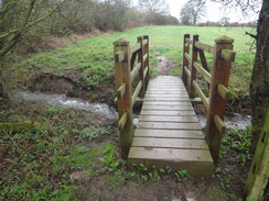
Head under the railway bridge and continue on along a track on the other side; after ten metres turn left off the track to join a footpath that soon curves right through a gap in a hedge to enter a scrubby field. Turn left and head on, keeping a hedge on the left; at the corner of the field cross a footbridge over a stream and continue following a hedge on the left; it soon passes under some power lines overhead. At the far corner of this field, cross a footbridge over a ditch to enter a third field at SP88799296.
Continue following the hedge on the left of the third field; at the corner, cross another footbridge over a ditch and head on across a fourth field, still with a hedge on the left. When the hedge turns left after a few metres, angle right across the field, aiming for the bottom hedge. Go through a gap at a bend in the hedge to enter a fifth field. Turn left to walk on, keeping a field to the right whilst the hedge curves away to the left. The hedge soon rejoins on the left; before the corner of the field is reached, turn left across a footbridge over a ditch to reach a clappergate. Go through this to enter a sixth field. Keep a hedge on the right, and in the far corner of the field, go through a clappergate, cross a plank bridge over a ditch, and then go through a second clappergate to enter a seventh field at SP88229257.
Head across the seventh field, keeping the hedge on the right; at the end of the field go through a clappergate with a field gate off to the right to enter an eighth field; angle slightly to the left, aiming for a corner of a hedge ahead and to the left. When the hedge is reached turn right, keeping the hedge on the left and the field to the right. Follow the hedge as it curves to the right at the end of the field, and then turn left over a footbridge over a ditch to enter a ninth field. Head straight across the middle of this field, aiming for a gap in a hedge ahead at SP87349207.
At the gap, cross a footbridge over a ditch to enter a tenth field and head on, following a hedge on the left. At the far corner of this field, cross a plank bridge over a stream and follow a fence on the right for about five metres to reach a clappergate. Go through this to enter an eleventh field; turn slightly to the right, aiming for a corner of a hedge ahead. At the corner-hedge, go through a clappergate and continue on between fences to reach a surfaced track. Follow this for a short distance past a vehicle barrier until it reaches the A6003 road in Rockingham at SP86749156.
The rest of this walk follows the same route in reverse for completeness, here are the full directions
From the A6003 road in Rockingham at SP86749156, head down a small access road leading to (in 2018) Rockingham Landrovers. Pass a vehicle barrier and head on across a small yard and past a thatched cottage on the right. A path then runs between fences for a short distance to reach a clappergate that leads into a field. Turn half-left down the field, aiming for the far right-hand corner. Go through a clappergate in the hedge, and then turn right to follow a fence on the left for about five metres to reach a plank bridge that crosses a stream to enter a second field. Head across this field, keeping the hedge on the right; at the corner follow the hedge as it curves to the left, and then turn right across a footbridge over a ditch at SP87349207 to enter a third field.
Head straight on across the middle of the third field (there are no hedges or fences), and at the far side cross a footbridge over a ditch to enter a fourth. Turn right to follow a hedge on the right; this soon curves to the left. When the hedge turns sharply to the right, turn half-left across the field, aiming for a tree in a hedge. Go through a clappergate with a field gate near the tree to enter a fifth field. Continue across this field, keeping a hedge on the left, until the corner is reached at SP88229257. Go through a clappergate, cross a plank bridge over a ditch, and then go through a second clappergate, to enter a sixth field.
In the sixth field, keep a hedge on the left for a short distance until it turns sharply right; go through a clappergate ahead and cross a footbridge over a ditch to enter a seventh field. Head straight on across this field with a hedge away to the right; the hedge soon joins the path, and when it does, turn right through a gap in the hedge to enter an eighth field. Turn slightly to the right to angle away from the hedge on the left, aiming for a corner of a hedge ahead. At the corner, go through a gap in a hedge to enter a ninth field. Continue on with a hedge on the right; this soon reaches the field corner, where a footbridge over a ditch at SP88799296 that leads into a tenth field.
Follow a hedge on the right past the tenth field; pass under some power lines and at the corner, cross a footbridge over a stream to enter a scrubby field, the eleventh of this section. Roughly keep a hedge on the right, and at the next corner, turn right through a gap in a hedge to join a path that soon ends at a track. Turn right up the track for about ten metres until a bridge under a railway line is reached at SP89309327.
Pass under the bridge and turn left to reach a clappergate. Go through this, and on the other side turn left along a path that descends with the railway embankment to the left and a fence to the right. After 150 metres a clappergate is reached; go through this to enter a field, and turn right to head uphill, angling slightly away from the hedge on the right. The path climbs steeply to reach a clappergate through a hedge at the top of the field. Go through this to enter a second field; head straight on across this along an obvious path towards a double field gate in front of some houses ahead. Squeeze to the right of the gates to join a path that follows a hedge on the right before emerging out onto a short access road, which soon ends at Corby Road in Gretton. Carefully cross the road, turn right for a few metres, and then turn left up Kirby Road. Follow this road as it passes Gretton primary school on the right and the village hall on the left. After 500 metres, on a left-hand bend, a track leads off to the right at SP90239443.
Leave the road and turn right up the track; it becomes rougher as it approaches a barn on the right. As the track curves right past the far end of the barn, continue straight on through a gap in a hedge to enter an area of newly-planted woodland. Head straight on along a path to reach a gate through a hedge. On the other side, cross a rough track and head straight on across a second field, descending into a little dip and climbing up the other side to reach a gate. Go through this into a third field, and angle slightly to the right. Skirt (but do not join) a corner of a hedge on the right, and head on to the far corner of the field. Go through the gate into a fourth field, and then immediately turn left to reach a second gate that leads into a fifth. Turn right to head along this field, keeping the hedge on the right. When the corner of the field is reached after about 500 metres, turn left to follow some trees on the right that guard a deep cutting beyond them. Just before the corner of the field is reached, a bridleway gate beside a field gate is met on the right at SP91699448.
Go through the bridleway gate and head straight on across a filled-in section of cutting. On the other side the path turns left, running between the cutting on the left and a fence on the right. Follow the obvious path as it swings to the right through a gap to enter a field; do not continue straight on along the cutting. Angle to the left across the field, aiming for a gap between trees on the left and woodland on the right, and after about ten metres angle left to continue on paralleling the woodland away to the right. After nearly 400 metres, a rough track is reached ahead. Join this and continue straight on along it for a little over 0.7 miles; it passes a lake on the left and when the lake ends, the track curves to the left to pass the end of the lake. It then climbs slightly before ending at a surfaced road with a farm away to the left. Turn right down this road for about fifty metres, and just before a cattle grid is reached in front of a house, a rough track leads off to the left at SP93269532.
Turn left off the surfaced road to join the track as it runs through a narrow field, initially following a low stone wall on the right. The path curves to the left to reach a tennis court on the left; cross a stile over a low stone wall to enter a second field. Turn right to head north along the field, with the wall, and then a hedge, on the right. At the corner of the field, turn right through a gap in the hedge into a third field, and then turn immediately left through another gap to enter a fourth. Ignore a path angling off to the left, and instead head straight on across the field. Go through a pedestrian gate beside a field gate and continue straight on, aiming for the field's far corner. Once there, go through a broad gap to join a track, and then turn right up the track for a few metres past a vehicle barrier to meet a road. Turn left along the road for forty metres until just before the brick parapet of an old bridge is reached at SP92799642, with a stile on the right.
Turn right across the stile to enter a field. Turn half-left to angle towards a gap in the hedge a few metres away on the left, and go through this to enter a second field. Turn half-right to head diagonally across the field; crest a slight slope and then head on towards the corner of a field ahead. Join the hedge, and then follow a fence on the right downhill. At the corner of the field, go through a pedestrian gate and head on down a third field, with a hedge on the right. Near the bottom of this field, turn right through a bridleway gate into a fourth field. Turn left down this field for a short distance to reach another bridleway gate. This leads to a narrow path that runs between fences guarding gardens on either side. The path curves sharply to the left, and emerges out onto a gravel area at the top end of a public road in Shotley. Turn right down the road until a red-brick chapel is reached on the left at SP92799642.
Pass the chapel, and then turn left down a path that heads downhill, initially between fences. This emerges out onto Wakerley Road; continue along it westwards as it enters the village of Harringworth. After 400 metres there is a left-hand bend, with a track coming in from the right at SP91889738.
Turn right to join the surfaced track for a few metres; go through a gateway, and then immediately turn right through a clappergate to enter a field. Turn half-left to head diagonally down the field, aiming for the bottom corner near the river. At the bottom corner, turn right to go through a clappergate in a hedge to reach a track that leads onto a river bridge. Cross the track, and on the other side cross a plank bridge over a ditch to enter a second field. Follow the river on the left across this field; when it ends cross a plank bridge over a ditch to enter a third field. When this ends, cross a stile (or go through a large gap in the hedge alongside) to enter a fourth field. Continue following the river until Turtle bridge is reached on the left at SP92809850.
Turn left to cross the bridge and continue along the track. It starts to climb; after 150 metres, and just before a railway bridge is reached ahead, turn right down a grassy slope for a few metres that leads to a stile embedded in a field gate. Cross this to enter a field and turn left, keeping the field boundary to the left. This soon curves to the right to start following an old railway line over the hedge on the left. Cross four fields, each guarded by a stile beside a field gate or gateway, and at a crest of a slight slope in the fourth field, cross a stile beside a double field gate on the left to enter a section of filled-in cutting. Head straight on towards a track ahead, but then turn right through a gap in a hedge to enter a field. Keep the hedge and old railway line on the right as you head downhill.
After 400 metres in the field at SP94019949, turn half-left to head diagonally up the field, aiming for a gap between a corner of a hedge and the end of a hedge at the top. Go through this gap into a second field, and continue straight on past a wooden electricity pole to reach a stile in a hedge. On the other side, head straight on diagonally across a third field to reach a stile in a fence that leads out onto the surfaced access road leading to Durant Farm. Turn left to follow this for forty metres until it ends at a T-junction with a road. Turn right up this road for fifty metres until it too ends at a T-junction. Take the first road off to the right, Main Street, and follow it for 400 metres into the village of Barrowden. Just before the village pond is reached, turn left up a road for a few metres to reach the Exeter Arms in Barrowden at SK94640009.
Distances
| From | To | Distance (m) | Ascent (ft) | Descent (ft) |
|---|---|---|---|---|
| Barrowden | Rockingham | 9.6 | 479 | 406 |
| Rockingham | Barrowden | 9.8 | 418 | 491 |
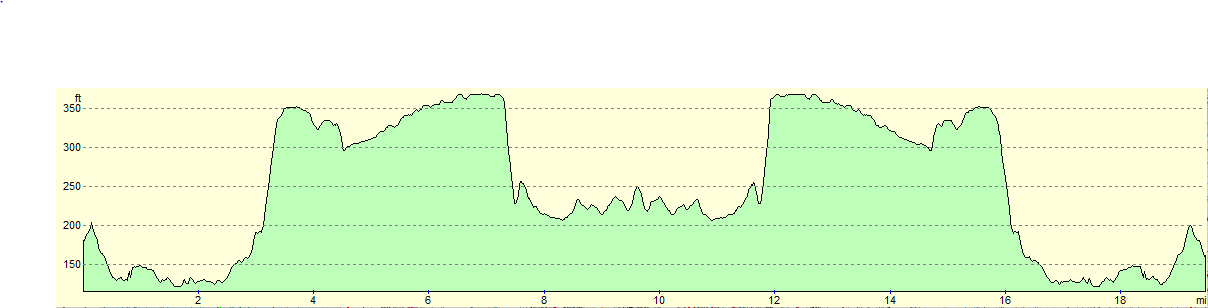
This makes a total distance of 19.4 miles, with 897 feet of ascent and 897 feet of descent.
For more information on profiles, ascents and descents, see this page
 |
 |
|
 |
 |
|
 |
 |
|
 |
 |
|
 |
 |
|
 |
 |
|
 |
 |
|
 |
 |
|
 |
 |
|
 |
 |
|
 |
 |
|
 |
 |
|
 |
 |
|
 |
 |
|
 |
 |
|
 |
 |
|
 |
 |
|
 |
 |
|
 |
 |
|
 |
 |
|
 |
 |
|
 |
 |
|
Disclaimer
Please note that I take no responsibility for anything that may happen when following these directions. If you intend to follow this route, then please use the relevant maps and check the route out before you go out. As always when walking, use common sense and you should be fine.
If you find any information on any of these routes that is inaccurate, or you wish to add anything, then please email me.
All images on this site are © of the author. Any reproduction, retransmissions, or republication of all or part of any document found on this site is expressly prohibited, unless the author has explicitly granted its prior written consent to so reproduce, retransmit, or republish the material. All other rights reserved.
Although this site includes links providing convenient direct access to other Internet sites, I do not endorse, approve, certify or make warranties or representations as to the accuracy of the information on these sites.
And finally, enjoy your walking!
Nearby walks
| # | Title | Walk length (miles) |
|---|---|---|
| 58 | Stamford to Oakham | 16.8 |
| 647 | A circular walk from Oundle to King's Cliffe | 19.6 |
| 692 | Stamford to Oakham | 16.8 |
|
|

|