Walk #128: The Castleton Ridge circular walk
 |
 |
|
General Data
| Date Walked | 09/12/2000 |
| County | Derbyshire |
| Start Location | Castleton |
| End Location | Castleton |
| Start time | 10.15 |
| End time | 13.55 |
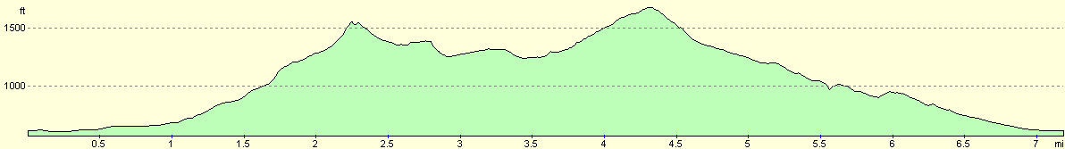
| Distance | 7.1 miles |
| Description | A circular walk taking in the Castleton ridge from Lose Hill westwards to Mam Tor. |
| Pack | Today I carried a pack with no tent or cooking apparatus |
| Condition | I feel fine after this walk. I have no problems at all, and indeed could have extended the walk if I had wanted to. My feet are okay, although my shoulders ache slightly as I did not use the chest strap on my rucksack. |
| Weather | The main feature of today's weather was the very strong wind, which came near to knocking us off our feet on a couple of occasions on the highest points of the ridge. The wind was accompanied by periods of cold rain or drizzle blasting into us from the sides and the front. Fortunately these periods did not last too long, and did not effect our dryness. There were also periods of sunshine. It was cold, however, especially in the wind. |
| OS map | Outdoor Leisure number 1 (The Peak District - Dark Peak Area) |
 |
 |
|
Map of the walk
Maps courtesy of Google Maps. Route for indicative purposes only, and may have been plotted after the walk. Please let me have comments on what you think of this new format. For a detailed table of timings for this walk, please see the table file.
Notes
This was an interesting day, the main purpose of which was to see if my new girlfriend like hillwalking. She came out with this statement that she would like to come walking with me in Scotland on sections of my Land's End to John O'Groats walk next year. Since she has never done any hillwalking before, I decided it may be an idea to show her exactly what it involves.
I chose the Castleton area as it is an area that I know very well, with some steep but not too serious hills, some excellent views from the ridge and many escape routes / shortcuts if it all got too much for her.
Fortunately, after the initial shock of the climb up Lose Hill ("How far to the top now?") she acquitted herself quite well, and did not slow me up much, which is a good sign. She is also keen to do some more walking with me soon, although next time I may got for a lowland area where we can get a bit more distance walking done.
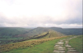
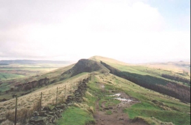
The Castleton Ridge is probably one of the best hill walks in Derbyshire (excluding the dark morass of Kinder and Bleaklow, which are more plateaus than hills in my opinion and do not have stupendous views from the top). It is also *very* popular, and on this walk there were plenty of signs of the path being paved with flagstones. On the climb from Hollins Cross to the summit of Mam Tor there were flagstones piled up ready for use, and a short section near the bottom had recently been completed. On the old road at the base of the hill there were more flagstones ready to be lifted by helicopter up to the ridge, along with bags of smaller packing stones. Also on the ridge was a little corrugated iron hut which I assume was for use by the workmen.
I cannot really understate how lovely the views from this walk are. Although they are not of the scale available in other places such as the Lake District they are exceedingly nice, and are also very accessible. There were plenty of people walking along the ridge, and in places it looked like the M1. There were also people walking along with improper clothing, jeans and trainers on! I myself had left my gloves at home, and my hands got very cold at certain stages of the walk.
From Mam Tor there are several alternative routes that can be taken; you can proceed eastwards down Rushup Edge, or curve to the south and then west and come down into Castleton via Cave Dale. Sam was slightly tired by this time, so I opted to take her down the old road.
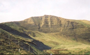
There are wonderful views available from the summit of Mam Tor, which is 1696 feet (517 metres) high. To the east is the Castleton ridge, to the north is the Hope Valley, Edale and Kinder Scout. To the west is Rushup Edge and the western Peak District. To the south is Castleton, Peveril castle and the White Peak. The summit of Mam Tor has an ancient Celtic hill fort on it, which has been dated to about 3,000 years. Mam Tor itself means 'mother mountain'.
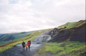
Mam Tor is known locally as the 'shivering mountain' because there are frequent landslips on the eastern face of the hill. There used to be the main A625 Sheffield to Manchester road running along this face, but after six or seven landslips it was finally abandoned in 1979. If you walk down it now you see a road surface that looks as though it has been in an earthquake, with great up thrusts and down thrusts in the road. It is quite an impressive sight.
Castleton itself is dominated by two things: Peveril castle, built by William the Conqueror's son, William Peveril, and the four main cave systems in the area (Peak Cavern, Speedwell Cavern, Treak Cliff and Blue John). Peak Cavern apparently is the largest cave mouth in Europe, and people used to live in the mouth making ropes.
Directions
Head out of the western (large) car park in Castleton. Turn left onto the A625 and follow it eastwards past the church until you come to a sharp left-hand bend. Take this bend and as the road turns sharply to the right continue straight on down Hollowford Road to the north. Hollowford Road continues in a roughly northerly direction, passing to the left of a cemetery. It soon reaches a junction with a minor road to the right. Take this road and pass to the right of a training and conference centre.
This track heads northeastwards. When it bends round to the left take a footpath that continues straight on. Cross over a stream and join another minor road. Shortly beyond Losehill Hall (now a National Park Study Centre) a footpath leads off to the left. This path follows the western bank of a stream past Field's Farm. It then crosses over to the eastern bank and starts climbing past Riding House Farm.
Shortly past the farm the path turns from roughly northerly direction to an easterly one, and joins a muddy unmetalled track. This crosses over a small stream and enters another field. Here the footpath leaves the track before it reaches Losehill Farm and strikes northwards uphill to a prominent fingerpost at 158848. At the fingerpost turn left and head uphill to the north along a footpath which soon veers northwestards. Over a stile the path becomes stepped on the steep approach to the summit of Lose Hill.
At the top of Lose Hill turn left and head down the very prominent footpath southwestwards along the ridge. This path descends down to a saddle and then rises slightly to the top of Back Tor. The path then descends steeply along a very stoney path to Backtor Nook. It then rises again along Barker Bank before descending to Hollins Cross.
The route to Mam Tor continues along the ridge as it slowly gains height and curves around to the south. After a little over a kilometre it reaches the trig point at the summit of the hill, from where some lovely views should be available.
From the trig point continue on and drop down some steps to a stile near the road in Mam Nick. A path from here leads westwards to cross the road and then climb Rushup Edge, but this route heads in a southerly direction for a short distance. At another stile a National Trust path leads eastwards across fields to meet the old A625 just north of the junction of the current A625 and B6061 roads.
At the road turn left and start the descent down the road. After a short distance a road leads off to a hut and a small car park to the right; this is an entrance to Blue John Cavern. The old A625 road continues downhill to a small coach turning circle. Beyond this the old road becomes disjointed to almost seismic proportions, as it has slowly slid down the hill. To the left can be seen the scarred eastern face of Mam Tor rising above.
Carefully make your way down the road, taking care not to fall off any of the eight-foot drops and cracks in the surface. Near Mam Farm the road meets a sharp hairpin and bends back on itself to head in a south-south-easterly direction. This section is also badly deformed, and although the tarmac has recently been patched it still exhibits some sharp increases and decreases in level.
The deformations in the road stops and it passes through a gate. Beside the gate is an information board giving information about the road slippage. Continue along the road past the entrance to Treak Cliff Cavern. There is a footpath beside the road all the way into Castleton. Just before the village is reached the road from Winnats Pass joins from the right. The merged roads then continue for a short distance into the village.
Distances
| From | To | Distance (m) | Ascent (ft) | Descent (ft) |
|---|---|---|---|---|
| Castleton Car Park | Lose Hill | 2.3 | 962 | 52 |
| Lose Hill | Mam Tor | 2.1 | 568 | 423 |
| Mam Tor | Castleton Car Park | 2.7 | 146 | 1201 |
This makes a total distance of 7.1 miles, with 1676 feet of ascent and 1676 feet of descent.
For more information on profiles, ascents and descents, see this page
Disclaimer
Please note that I take no responsibility for anything that may happen when following these directions. If you intend to follow this route, then please use the relevant maps and check the route out before you go out. As always when walking, use common sense and you should be fine.
If you find any information on any of these routes that is inaccurate, or you wish to add anything, then please email me.
All images on this site are © of the author. Any reproduction, retransmissions, or republication of all or part of any document found on this site is expressly prohibited, unless the author has explicitly granted its prior written consent to so reproduce, retransmit, or republish the material. All other rights reserved.
Although this site includes links providing convenient direct access to other Internet sites, I do not endorse, approve, certify or make warranties or representations as to the accuracy of the information on these sites.
And finally, enjoy your walking!
Nearby walks
| # | Title | Walk length (miles) |
|---|---|---|
| 13 | Edale and Kinder Scout | 11.0 |
| 19 | Castleton circular via Lose Hill and Mam Tor | 7.7 |
| 23 | The Limestone Way from Pomeroy to Castleton | 14.0 |
|
|

|