Walk #989: Nene Way: A fool's April walk between Warmington and Achurch and back
 |
 |
|
General Data
| Date Walked | 01/04/2018 |
| County | Northamptonshire |
| Start Location | Warmington church |
| End Location | Warmington church |
| Start time | 07.04 |
| End time | 14.11 |
| Distance | 20.3 miles |
| Description | This was an interesting walk, mostly following the Nene Way, except for a diversion due to floods. |
| Pack | Today I carried my 30-litre Karrimor rucksack, filled with water, my spare waterproofs, a book and other odds and ends. |
| Condition | I feel absolutely fine after this walk. |
| Weather | Aside from a shower just before and after I walked, the day was thankfully dry. It was a little chilly early on, but the day soon warmed up, and there was no breeze. |
| OS map | Landranger number 141 (Kettering, Corby & surrounding area) and Landranger number 142 (Peterborough, Market Deeping & Chatteris) |
 |
 |
|
Map of the walk
Maps courtesy of Google Maps. Route for indicative purposes only, and may have been plotted after the walk. Please let me have comments on what you think of this new format. For a detailed table of timings for this walk, please see the table file.
 |
 |
|
Notes
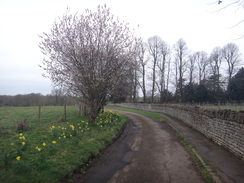
The last week had continued the trend started on the last walk, in that the weather had been very wet. Because of this I had not managed to get a walk done, and today was the only day with a dry forecast in the next week. Sencan gave me permission to disappear for the day, but being not only a Sunday, but Easter Sunday, I did not want to risk having to rely on public transport. Fortunately there were several there-and-back walks I need to do on the Nene Way, so I got up early and drove to Warmington, where I had ended a previous walk.
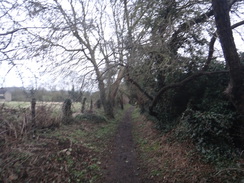
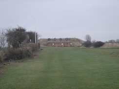
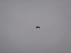
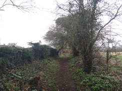
I parked up in a road near the church just as it started to rain; I waited for the shower to finish, and decided to head out in my fleece rather than my coat. The trail left the village down a narrow lane, which led to another road and then a track - apparently once a Roman road. This crossed a ford over a stream and headed on, becoming surfaced as it passed a barn with weighbridge. A green lane headed on towards a white pole, and a sign warned of a shooting range, apparently belonging to Oundle School. There was no red flag fluttering atop the pole, so I wandered past a series of berms and some distant targets. Since the trail crosses the range and there are no obvious diversions, I do wonder how compatible the path and range are. A couple of raptors flew overhead, with notched fan-tails: I am hopeless at bird identification, but I think they were Kites. I watched as they magnificently swooped and glided overhead.
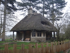
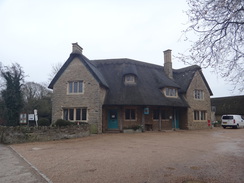
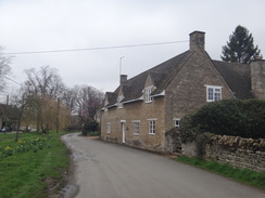
The track become a road, which passed a small thatched cottage called 'Entrance Lodge' (presumably the 'entrance' referring to Ashton Wold House to the east), and then turned to enter the little village of Ashton. This was very pretty, with the stone houses so common in Northamptonshire, many topped off with thatched hats. I passed the village pub - unusually only marked by a sign of a butterfly rather than a name - and headed down a path towards the valley floor.
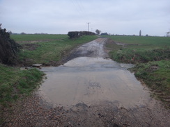
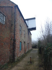
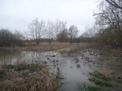
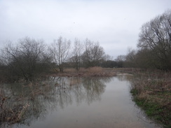
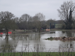
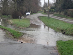
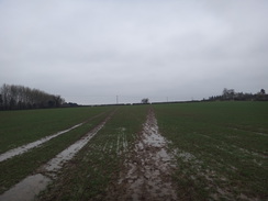
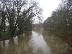
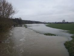
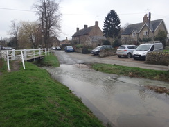
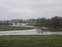
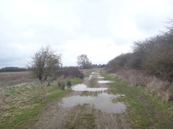
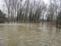
Here I found my fears were founded, as the floodplain seemed to be more flood than plain. More in hope than expectation, I headed past a wonderfully unrestored mill to find the path soon petered out into floodwater. I was tempted to stride on through, as the path was visible underneath the water, but as it headed towards the river it could only really get deeper. Worse, the trail follows the riverbank in a winding course around Oundle, meaning that attempting to follow it would be foolhardy. I felt more than a little foolish for having decided on this walk.
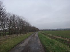
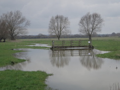
A quick study of the map showed an alternative route to bypass the riverside section, which would allow the Nene Way to be rejoined just north of Barnwell. This involved a long road walk that initially skirted the floodplain. It was clear I had made the right decision, as the floodwaters were almost lapping the road before it climbed uphill, passing a nursery specialising in olive trees and Mediterranean plants. The road then descended into a little valley where a stream overwhelmed a farm bridge in a field before sweeping into the floodwaters.
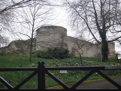
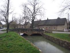
Eventually the road turned to enter Barnwell, and I rejoined the Nene Way. The top of the ruins of Barnwell Castle were visible over the fence, but signs warned of cameras and forbade access - a shame, especially as the photos of the ruins online appear spectacular. Fortunately Barnwell itself made up for missing out on the castle; it is a perfect example of a Northamptonshire village and is picture-perfect, with a brook burbling (due to the rain, more like roaring) down the street between the wide-set thatched houses. Few people were about, and I ambled along, enjoying the scenery.
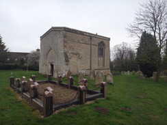
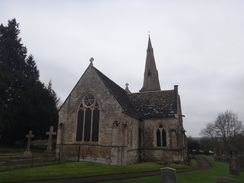
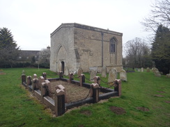
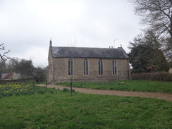
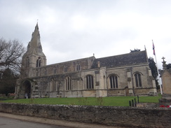
The trail left the village via a churchyard that contained a very odd little church, which seemed more like a rectangular chapel. This is the chancel of All Saints' church, the remnants of an early 13th-Century church that was mostly pulled down in 1821, leaving this small portion behind. It is an odd-looking structure, shaped more like a Victorian chapel than a Medieval church. A path across a field led to the old Northampton to Peterborough railway line, which it crossed near what I thought was an old station building, but a check when I got home showed that the station was actually further north. The building does look like an enlarged railway structure, so my best guess is that it was once a crossing cottage. I saw a bird overhead, looking remarkably like the one I had seen several times earlier, and I started to wonder if I was being followed.
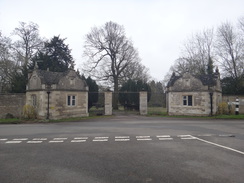
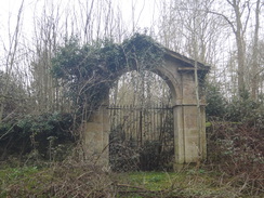
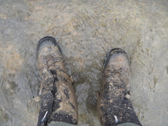
The trail then headed across fields that were waterlogged in places, and I slowly squelched across them until firmer ground, and then a road, was reached. The next couple of miles were along roads; one led to a junction near an old railway overbridge, and the next to a busy roundabout with the A605. A quieter road led down past a magnificent gateway leading to Lilford Hall, a grade-I listed stately home that sadly was not visible from the road. The estate might be partly opened up to the public to commemorate Robert Browne, who was lived there and inspired the movement that led to the Mayflower voyage - indeed, for 200 years the Pilgrims were known as 'the Brownist Emigration'. I have come across several references to the Pilgrims on my walks - for instance outside Boston - and it feels odd to find a reference in such a land-locked site. A few metres further on, in the other side of the road sat an archway, seemingly leading to nowhere.
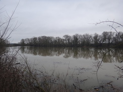
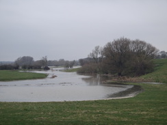
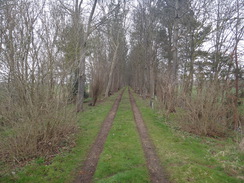
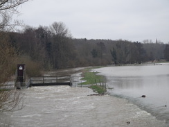
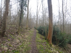
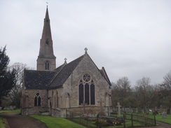
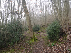
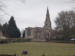
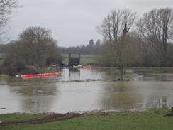
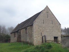
The road led down towards the river, and I diverted off the trail to cross the two bridges over the river. Lilford lock was overflowing, and the surrounding land was a mass of flowing water. I headed back to the Nene Way, and I considered turning back. However I was still feeling fit, and so I decided to continue along the next stretch. This led through some woodland, the path underfoot muddy enough to force me to get my walking poles out. A steep climb up some steps and a path through the trees led to a road, and then onto the tiny and oddly-named Achurch church.
From here the trail heads down onto the floodplain towards Wadenhoe, and a quick glance showed that the floods meant that the trail would be impassable. There seemed little point in descending down across the muddy field, and as I had already done about ten miles the church seemed like a good place to end this part of the walk.
The trip back was uneventful; the roads were slightly busier at the later hour, and there were more people about, including children swinging on a rope-swing in the centre of Barnwell. The only thing of particular note was the bird - or was it the same one? - that I would see hovering overhead every so often. Although the logical side of me said that I was seeing different birds, I could not help but feel like I had some form of avian spirit-guide.
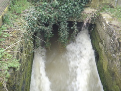
Perhaps it was the birds' influence, but the return journey seemed to fly, and I soon found myself back at my car in Warmington. I still felt fit, so instead of heading home I walked through the village towards the river, a stretch I walked on a previous trip. As expected the river was full, with water streaming forcefully from under the mill. A little further on, a footbridge over what had been a dry ditch was nearly surrounded by water. It looked just about possible to get to the nearby lock, but I had little idea if that would be flooded as well.
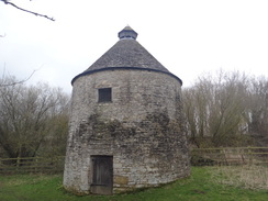
But that was enough for me. I headed back to my car, diverting off on the way to visit the villages dovecot, which is a short distance away from the trail. This is a small but well-maintained dovecot, and it made an interesting end to the day's stroll.
It had been a slightly annoying day, and I shall have to come back to do the four riverside miles around Oundle when the river levels have fallen. Despite that I had enjoyed the walk, and am looking forward to the next stretches.
 |
 |
|
Directions
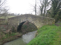
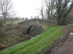
This walk starts off at Warmington church at TL07749100. from the church's main entrance, turn left along Church Lane for a few metres, and then turn right down Long Lane, initially with a house on the right and a low stone wall on the left. The lane passes a house on the right and becomes narrower between trees, before emerging out onto another road called Taylor's Green. Turn right along the road, and at a triangular junction take the left-hand branch to head straight on. When this road soon ends at a gateway leading into a farm, turn left along a track. This passes the farm on the right and descends to cross a stream on a ford. Cross the stream and continue on; the track passes a barn on the left and then a house on the right, at which point it becomes surfaced. After two-thirds of a mile, the track ends at a T-junction with a road at TL06898984.
Carefully cross the road, pass a vehicle barrier and continue straight on along an unsurfacaed track. After nearly a third of a mile, a bridleway leads off to the right; continue straight on past another vehicle barrier to reach some barns on the right. Here the track becomes a surfaced road, and it crosses a rifle range. 0.6 miles after the barns, the road ends at a road junction, with a thatched cottage off to the left at TL06128836.
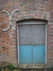
Turn right to head west through the little village of Ashton, passing the Chequered Skipper pub on the left. When the road starts to curve to the left out of the village, join the pavement on the right and follow it alongside a low stone wall guarding a chapel on the right. An access road curves right to cross the path; cross it and head on to reach a clappergate. Go through this and follow a grassy path downhill between fences. At the bottom, go through another clapper gate and down some steps to reach a road. Carefully cross the road to reach the pavement on the other side, and then turn right to follow the road for about thirty metres. When a mill is reached, turn left down an access road, aiming for a path that squeezes past a red-brick mill building on the left. This emerges out to a gate at TL05138820.
Here I had to leave the Nene Way due to flooding and take a different route. Head back towards the mill and then turn right along the road, soon passing the steps you went down earlier. Head on along the pavement on the right and continue following the road uphill; the pavement swaps to the left-hand side of the road, and after two-thirds of a mile, a road junction is reached at TL05948744. Turn right to start following the road south-southwestwards. It descends to cross a small stream on a bridge before climbing. 0.9 miles after the road junction, the road curves to the right as another road joins from the left. Continue around the bend to pass an area of woodland on the left, and then around a left-hand bend. The road passes houses on the left, and on the next left-hand bend the Nene Way rejoins from the right at TL04788562.
The road continues on southwards, winding right and left past the grounds of Barnwell Manor and the ruins of Barnwell Castle on the left. When a road leads off to the left at a right-hand bend at TL04838518, turn left along the road, following a stream on the right. The road curves to the right beside a brook as it enters Barnwell, and after 450 metres ends at a T-junction beside the Montagu Arms in Barnwell at TL05028485.
Cross the road ahead, and continue south along another road through the village beside the brook. When a ford is reached, cross the brook using the footbridge alongside and continue along the road up a slight slope. 100 metres after the ford, turn right up a short access track towards a house, but before the driveway is reached turn left across grass to reach a clappergate that leads into the old churchyard of All Saint's church at TL04868441.
Angle diagonally across the churchyard, passing the corner of the old chancel, and in the far corner go through a clappergate to enter a field. Turn left to parallel a field boundary on the left; at the corner of the field go through a bridleway gate beside a field gate to enter a second field. Continue past this until a barn is approached away to the left, and then angle half-right diagonally across the field, aiming for the opposite corner. Go through a pedestrian gate and turn right to climb a bank onto an old railway trackbed at TL04708399.
Cross this and descend the other side, heading between hedges to enter a field. Turn half-left across the field, aiming for halfway up the far hedge. Cross a footbridge through the hedge into a second field and continue straight on, aiming for a hedge corner ahead. Join the hedge, and keep it on the right. At the corner of this field, do not go through a broad gap ahead and instead turn right through a smaller gap in the hedge on the right to enter a third field. Turn left to start following the hedge on the left. When the hedge ends, continue alongside a small ditch on the left between fields. A hedge starts on the left, protecting a house beyond, until the path ends at a road in Wigsthorpe at TL04358277.
Head straight on down the road, passing a farm on the left; after 700 metres this road ends at a T-junction with the B662 at TL04058213, with an old rail overbridge immediately to the left. Turn right down the B662; there is no pavement, but the verges are wide. After a little over half a mile the road reaches a roundabout with the A605. Carefully cross the roundabout and continue straight on down another road. This passes some woodland, and after another 0.6 of a mile reaches a road junction to the left, with an ornate gateway to the right. Continue on as the road heads downhill, and just before the bridges over the Nene are reached, turn left through a clappergate beside a gateway at TL02688376.
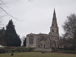
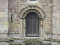
Go through a clappergate next to a gateway and continue on, with a fence on the right. When the track curves to the right, turn left to head straight on along a narrow path through the trees. The path slowly climbs, before curving to the left and climbing some steep steps. At the top, continue on for a short distance until a crosspath is reached. Turn right along a path that heads south-southwestwards through the trees; after 370 metres this ends at a road opposite a stone house. Turn right down this road, following a ramshackle low stone wall on the right. After 150 metres the road ends at a rather imposing church gateway. Go through the gate to enter Achurch churchyard; head straight on to reach the church at TL02158313.
The directions from here are simple; just follow the same route back to Warmington. However below are the directions in detail:
Leave the churchyard through the main gate to join a road. Head down this road for 150 metres, following a ramshackle wall on the left. Just before a house is reached on the right, turn left pat a field gate to join a rough track that enters woodland. Follow the rough track through the trees; when a crosspath is reached after 370 metres, turn left down a rough path. This soon descends down steps and curves to the right. It slowly descends through the trees to meet a track in front of a fence. Turn right down the track, passing a house on the left (probably related to the adjacent lock), following the fence on the left to reach a clapper gate beside a gateway that leads onto a road at TL02688376.
Turn tight to follow the road southeastwards away from the bridge over the river; after 0.6 miles it ends at a roundabout on the A605 road. Carefully cross the roundabout, and continue straight on along the B662 road. 0.6 miles after the roundabout and just before a bridge over an old railway line is reached, a road leads off to the left. Turn left and follow this road for half a mile until it ends at a T-junction in the hamlet of Wigsthorpe at TL04358277.
Cross the road and head straight on, passing a house guarded by a hedge on the right. When the hedge ends, continue straight on, following a small ditch on the right. The ditch ends and is replaced with a hedge. Just before the corner of the field is reached, turn right to cross the ditch, then go through a gap in the hedge, and on the other side turn left to follow the hedge on the left. When the hedge turns away to the left, continue straight on across the field to reach a footbridge that goes through a hedge to enter a third field. Turn slightly to the right, aiming diagonally for the far bottom right-hand corner of the field. At the corner cross a ditch and turn right to join a narrow path that runs between hedges. This soon climbs up to the top of an old railway embankment.
Cross a the top of the embankment and descend through a pedestrian gate into a field. Turn half-left to head diagonally across the field, aiming for a barn on the other side of the hedge. When the hedge is reached, turn left to follow the hedge on the right. Go through a bridleway gate beside a field gate at the end of the field and continue across the next field, following the field boundary to the right. At the corner of the field, go through a clappergate in a stone wall to enter a churchyard. Turn half-right through the churchyard, passing the corner of the truncated church. In the far corner of the churchyard, go through a clappergate and cross an area of grass to reach a road in Barnwell at TL04928445.
Turn left down this road, it soon reaches a ford over the Barnwell Brook. Cross the footbridge beside the ford and continue along the road until it ends at a crossroads. Head straight on, passing the Montagu Arms on the right, and follow the road as it curves to the left alongside the brook on the left. 450 metres after the crossroads, the road ends at a T-junction. Turn right up the road and follow it as it curves to the left. On the next right-hand bend at TL04788562, the Nene Way heads off to the left. However due to flooding my route bypasses the river sections.
Continue straight on along the road past some houses on the right. The road curves to the right and then the left; at the latter bend a road joins from the right. Head on along the road as it descends to cross a bridge over a stream, before climbing once more and ending at a T-junction at TL05948744. Carefully cross the road ahead and turn left to start following the pavement on the right-hand side of the road. The road descends downhill, and the pavement swaps over to the left-hand side of the road. Two-thirds of a mile from the junction, a road is passed coming in from the right. Walk on towards Ashton Mill, but before it is reached, at TL05228820, turn right to carefully cross the road.
On the other side of the road, head up some steps that lead to a clappergate. Go through this and follow a path that runs between fences before ending at another clappergate. Follow a stone wall on the left, as a track joins on the right. The track soon ends at a road in Ashton at TL05528828.
Continue straight on along the road; after nearly half a mile turn left along another road. After another half-mile the road ends near a rifle range, and a good track continues onwards. Pass some barns on the left and a vehicle barrier; continue on along a green lane to reach another vehicle barrier guarding a road at TL06898983.
Cross the road to follow a track that passes a farm on the left and a large barn on the right. It then becomes unsurfaced and crosses a ford; after 0.7 miles this passes another farm. When the track forks, take the right-hand fork which soon ends at Taylors Green road in Warmington. Turn right down this road for a short distance to reach a triangular road junction, and then continue straight on along a narrow lane. After a driveway on the left, a narrow path called Long Lane heads off to the left between hedges. This becomes a lane that after 200 metres emerges out onto Church Street opposite Warmington church at TL07749100.
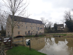
I extended the walk by heading up to the mill to see the floodwaters.
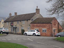
Turn right along Church Street for a few metres, and then left to head up Church Lane, which runs past the churchyard's eastern end. When the lane ends at a T-junction, turn left along Hautboy Lane, which curves to the right and passes Glebe Stores before itself ending at a T-junction. Turn left along Chapel Street, which curves right to pass an old chapel on the left. A road comes in from the left, with the Red Lion pub nearby, and the road curves to the right to merge with Peterborough Road. Carefully cross Peterborough Road, and then turn left down Eaglethorpe. When the road ends, go through a bridleway gate and follow a surfaced path that soon passes through an underpass below the A605 at TL07469159. On the other side, continue on past a squeeze fence and then cross a stream on a bridge to reach the mill.
From the mill, return to the underpass. On the other side of the underpass, go through a bridleway gate and continue on as the path becomes a lane called Eaglethorpe; follow this past houses for a short distance until it forks; take the right-hand fork until the road ends at a T-junction with Peterborough Road. Carefully cross this and turn right for a few metres until Chapel Street leads off to the left. Pass an old chapel on the left, and then shortly after the road curves to the left, turn right down Hautboy Lane. This also curves to the left, and a few metres after the bend turn right down Church Lane. Follow this for a short distance until it ends at a T-junction with Church Street, with the church off to the right at TL07749100.
Distances
| From | To | Distance (m) | Ascent (ft) | Descent (ft) |
|---|---|---|---|---|
| Warmington church | Barnwell | 5.6 | 213 | 190 |
| Barnwell | Achurch | 4.2 | 200 | 180 |
| Achurch | Barnwell | 3.9 | 154 | 174 |
| Barnwell | Warmington church | 5.5 | 180 | 203 |
| Warmington church | Warmington church | 1.1 | 23 | 23 |
This makes a total distance of 20.3 miles, with 770 feet of ascent and 770 feet of descent.
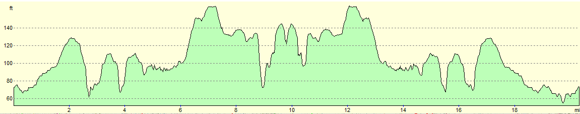
For more information on profiles, ascents and descents, see this page
 |
 |
|
 |
 |
|
 |
 |
|
 |
 |
|
 |
 |
|
 |
 |
|
 |
 |
|
 |
 |
|
 |
 |
|
 |
 |
|
 |
 |
|
 |
 |
|
 |
 |
|
 |
 |
|
 |
 |
|
 |
 |
|
 |
 |
|
 |
 |
|
 |
 |
|
 |
 |
|
 |
 |
|
 |
 |
|
 |
 |
|
 |
 |
|
 |
 |
|
Disclaimer
Please note that I take no responsibility for anything that may happen when following these directions. If you intend to follow this route, then please use the relevant maps and check the route out before you go out. As always when walking, use common sense and you should be fine.
If you find any information on any of these routes that is inaccurate, or you wish to add anything, then please email me.
All images on this site are © of the author. Any reproduction, retransmissions, or republication of all or part of any document found on this site is expressly prohibited, unless the author has explicitly granted its prior written consent to so reproduce, retransmit, or republish the material. All other rights reserved.
Although this site includes links providing convenient direct access to other Internet sites, I do not endorse, approve, certify or make warranties or representations as to the accuracy of the information on these sites.
And finally, enjoy your walking!
Nearby walks
| # | Title | Walk length (miles) |
|---|---|---|
| 56 | Peterborough to Stamford | 16.5 |
| 643 | A circular walk from Thrapston to Oundle | 19.4 |
| 647 | A circular walk from Oundle to King's Cliffe | 19.6 |
|
|

|