Walk #56: Peterborough to Stamford
 |
 |
|
General Data
| Date Walked | 28/11/1999 |
| County | Cambridgeshire, Rutland |
| Start Location | Peterborough station |
| End Location | Stamford |
| Start time | 08.30 |
| End time | 14.45 |
| Distance | 16.5 miles |
| Description | This pleasant walk followed the Hereward Way between Peterborough and Stamford. |
| Pack | Today I carried full Pennine Way kit. |
| Condition | I feel very good after this walk, and I felt fine by the end of the walk. I was a little fatigued, but that is nothing unusual after such a walk. |
| Weather | Initially it was cold as the sun was just rising, but it soon warmed up. For most of the day it was quite warm for the time of the day. Later on it began to cloud over, until at the end of the walk it was quite cold with a stiffening breeze. There was no sign of any rain. All in all quite nice walking weather for the time of year. |
| OS map | Explorer number 227 (Peterborough) and Explorer number 15 (Rutland Water) |
Map of the walk
Maps courtesy of Google Maps. Route for indicative purposes only, and may have been plotted after the walk. Please let me have comments on what you think of this new format. For a detailed table of timings for this walk, please see the table file.
Notes
Today was a truly lovely day, of walking in an area made even lovelier by the fact that they had these strange up-and-down things that for the want of a batter word I shall call hills - not large hills, at most I was 75 metres above sea level, but large when you consider that since doing the Pennine Way all my walking had been in the Fens or alongside canals. It was nice to have some up-and-down for a change.
The scenery is quite nice along this section. It is certainly not the dramatic scenery that you get in the National Parks, but is nice, typical English countryside. As soon as you reach the area near Wansford and start climbing from the Fens you approach the A1(T) - only occasionally close enough to see it, but always close enough to hear the low, dull roar of the traffic. This is a walk to take a walkman and some nice music to listen to with you on. It is amazing how the noise of a busy road like the A1(T) carries for miles and miles.
Stamford is a lovely town, and well worth spending an hour or so pottering around in. There are some attractive buildings, and plenty of shops to spend time pottering around in whilst waiting for a train back to Peterborough.
Directions
From Peterborough station make your way to the River Nene. Go through the Rivergate shopping centre and join the path that follows the north bank of the river.
The path alongside the Nene is easy to follow and is an easy walk. In a few areas long sections of board walks have been installed over (presumably) boggy areas near the river bank. These are great for going fast, but are also very slippery after rain as I nearly found to my cost once or twice.
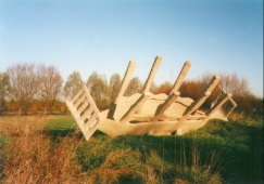
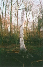
On this section of the walk the Hereward Way joins the Nene Way, and indeed I did not see a single Hereward Way sign on this entire section and hence you follow the Nene Way signs. There are also some strange structures and carvings that you may chance upon not too far outside of Peterborough's limits. One concrete... thing... (for I cannot think of a better way of describing it) near the end of the boating lake looks like a crashed alien spacecraft from one angle and from another like a giant receptacle of some kind. Goodness only knows what it is meant to represent.
A convenient half-way point on this walk is Wansford Station on the Nene Valley Railway, where you could catch a train back to Peterborough. Note however that this is a preserved railway, and hence may not be open all the year round.
Past Wansford station you stop heading west along the Nene Way, which heads off westwards, and continue northwards along the Hereward Way. Initially this follows the river but it soon leaves it and heads north along roads from Sutton to Southorpe. From here it heads north-west over fields through Burghley Park (home of the famous horse trials) and then along a road past a golf course. This section is very easy to follow as it is simply a straight line for a couple of miles - initially head for a gap in the tree line ahead and then continue straight on.
When you reach the B1081 road turn right down it for a short along a path beside the road while before turning left down a side road and right down fields and down to Stamford Station where you can catch a train back to Peterborough or go through a wander through the pretty town.
Distances
| From | To | Distance (m) | Ascent (ft) | Descent (ft) |
|---|---|---|---|---|
| Peterborough station | Sutton | 9.1 | 174 | 167 |
| Sutton | Stamford station | 7.4 | 322 | 262 |
This makes a total distance of 16.5 miles, with 496 feet of ascent and 429 feet of descent.
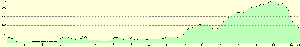
For more information on profiles, ascents and descents, see this page
Disclaimer
Please note that I take no responsibility for anything that may happen when following these directions. If you intend to follow this route, then please use the relevant maps and check the route out before you go out. As always when walking, use common sense and you should be fine.
If you find any information on any of these routes that is inaccurate, or you wish to add anything, then please email me.
All images on this site are © of the author. Any reproduction, retransmissions, or republication of all or part of any document found on this site is expressly prohibited, unless the author has explicitly granted its prior written consent to so reproduce, retransmit, or republish the material. All other rights reserved.
Although this site includes links providing convenient direct access to other Internet sites, I do not endorse, approve, certify or make warranties or representations as to the accuracy of the information on these sites.
And finally, enjoy your walking!
This walk was mentioned in the following routes:
| My sectional Land's End to John O'Groats walk |
Nearby walks
| # | Title | Walk length (miles) |
|---|---|---|
| 45 | Once Brewed to Bellingham | 15.4 |
|
|

|