Walk #982: Ouse Valley Way: Buckingham to Wolverton and Milton Keynes
 |
 |
|
General Data
| Date Walked | 21/02/2018 |
| County | Buckinghamshire |
| Start Location | Buckingham |
| End Location | Milton Keynes Central station |
| Start time | 07.22 |
| End time | 13.18 |
| Distance | 17.1 miles |
| Description | This was a varied walk following the Ouse Valley Way eastwards from Buckingham; initially I followed the course of the old Buckingham Canal, which was followed by paths and then a long riverside walk to Wolverton. Finally a few miles along roads took me to the railway and bus stations in central Milton Keynes. |
| Pack | Today I carried my 30-litre Karrimor rucksack, filled with water, my waterproofs, a book and other odds and ends. It also contained my trainers, in case I needed to appear neater for the return trip. |
| Condition | My feet feel slightly warm after this walk, but otherwise I feel fine. |
| Weather | Today was an overcast day, with little sight of the sun all day. However this also meant it was not too cold, and there was little wind to chill me either. All in all there are better winter's days for walking, but also much worse ones. |
| OS map | Landranger number 152 (Northampton & Milton Keynes) |
 |
 |
|
Map of the walk
Maps courtesy of Google Maps. Route for indicative purposes only, and may have been plotted after the walk. Please let me have comments on what you think of this new format. For a detailed table of timings for this walk, please see the table file.
 |
 |
|
Notes
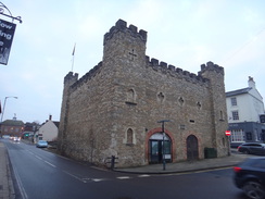
I only have two days of walking to do before I have completed the western section of the Ouse Valley Way, and I was keen to get it done soon. Therefore I set off early this morning for the hour's drive to Buckingham, and I arrived just as dawn was breaking. After parking in the long-stay car park behind the Waitrose I walked over to the toilet block - sadly the toilets were locked shut for the night. It seems Buckingham is a late-to-rise town, as the Waitrose, where I had hoped to buy some snacks for the day ahead, also did not open until eight. Not wanting to wait around, I set off on the walk.
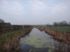
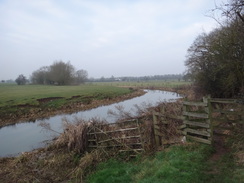
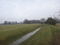
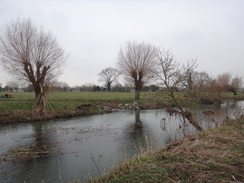
Fortunately there was a BP garage just down the road, and this provided me with some sandwiches and other snacks - most importantly water, as I have not yet sorted out my Platypus water bladders. They are not much needed in winter, but I'll have to start using them as we get into warmer weather. I left the road and headed down a good path past a rugby club - it as only when I got home that I discovered that this stretch of trail takes a slightly different route. Nothing much has been lost, as I can easily do this bit of 'missing' trail after the end of the next walk. The trail ran alongside the river, which was surprisingly wide given how near I was to its source.
Buckingham was soon left behind, and after crossing a road, I reached the course of the Buckingham Canal, which I would be following for the next few miles - in fact, I had been following parts of it from the road (the Terminus Wharf was near the BP garage), but all traces of it have disappeared. The canal was opened in 1800/1801, and the westernmost portion nearest Buckingham became disused a century later (partly because the town used it as a sewer). It was officially abandoned in 1964, and that was perhaps the end of that. However a brave group of men and women are working to have the canal reopened, and I immediately passed some of the fruits of their efforts: a few hundred metres of canal that is watered and navigable (if they could get a boat on it, that is).
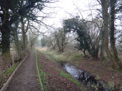
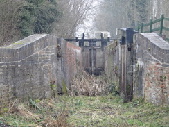
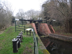
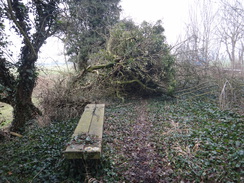
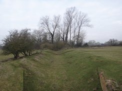
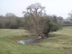
This section was soon left behind, and the canal bed essentially disappeared as it curved to the right to squeeze between the hillside and the river. The morning had started off cloudy and hazy, and the gloom had not lifted as I strode along, keeping an eye out for any signs of the canal. There were a few: an area of tall reeds where part of the canal bed was still intact, or a slight damp depression in the ground. However for much of the way nature and farmers had done a good job of filing in the canal and removing all traces - at least to my inexpert eye. It started to become more prominent as I approached a reservoir - presumably built to provide the canal with water - and soon afterwards I came across the biggest surprise of the day in the form of a lock hidden in the trees. It looked remarkably intact but also slightly dishevelled, with half-rotten lock gates and vegetation that needed cutting back. I guessed that it had been partly restored and perhaps abandoned, and I was partially correct: it had been restored, but the lock gates were old ones given to them, and hence are more cosmetic than practical. I dropped down into the dry canal bed to take a few photos from this rather unusual angle, and headed on.
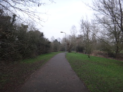
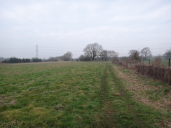
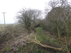
We have had a few gales recently, and this showed on the next section through an area of scrub woodland. Several trees and branches had fallen off and lay over the towpath; most could be easily negotiated, but I had to clamber over a couple. In spring and summer the woodland might appear glorious with grass and flowers, but the grey winter weather made it all look dismal. I am certainly not seeing this stretch of trail at its best. A road was crossed by Leckhampstead Wharf House, and the trail continued on across fields towards the A422. Friendly sheep followed me from stile to stile, as if they were expecting me to feed them, and looked almost disappointed as I would enter the next field to be greeted by their compatriots.
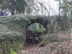
The trail flirted with the A422 before heading back along the canal bed. Another tree had fallen in an area of woodland, and this had totally blocked the path. Instead of scrambling over, I made a long diversion around it, but it was a relief when the woodland ended and the path followed the old canal bed, which at this point was a wide, dry ditch. A bridge over the canal seemed slightly incongruous, but soon the path reached another road near Thornton. However the canal had one last gem for me: a stone arch stood in front of the road bridge, the remains of the old bridge before it was bypassed. The stonework was overgrown with ivy, and appeared so flimsy that the vibrations from a passing lorry could have sent the whole thing down. It enchanted me, and I spent a few minutes taking photographs before heading on.
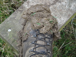
The Ouse Valley Way leaves the Buckingham Canal at the bridge, and heads down to another bridge over the river. A gateway stands opposite the point the trail leaves the road, and I stopped to take a photo of a sign on a gatepost. A man wearing a high-viz jacket approached, and asked me not to take any photos of the buildings. It turns out that the building is a girls' school, and we chatted for a few minutes: despite being a security guard, he had no idea a named trail passed directly by the entrance! He seemed very pleasant, and I set off across what turned out to be a muddy field. A deer stood in a stand of trees on the skyline, watching as I passed. It was still watching me as I left the field, and it was a shame I could not have got closer for a better photograph. The field was very muddy, and my boots were soon covered in thick clods of mud that would occasionally be thrown off as I took steps, hitting the backs of my leg.
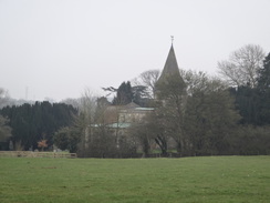
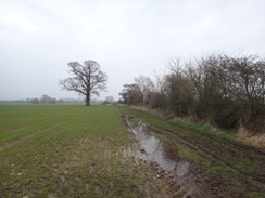
I made a mistake in the next field; instead of following the trail, I headed off and crossed a new gate into another field. It was obvious from the map I had gone wrong, but I got it into my head that I was right and waked on for a few minutes before it slowly dawned on me that the landscape looked very different to how it should from the map. I had little choice but to go back to where I had been, and I soon found a stile in the opposite corner to the one I had taken. Annoyed with myself, I headed on, soon reaching the church in Beachampton. This appeared a pretty village, but it was soon left behind as a path led across scrubby paddocks, and then a sometimes-waterlogged path headed on. It was a nondescript section of trail, although it may have a very different appearance in summer sun.
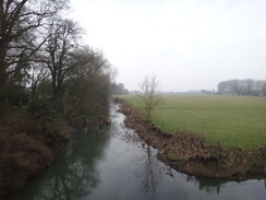
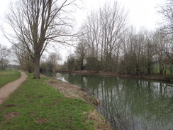
It was a relief when I finally reached a road on the outskirts of Calveron, as this marked the end of the first half of the day's walk. Whilst the first half had comprised dry canals and muddy fields, the second would mostly comprise hard paths alongside the river. The tone was soon set, as the trail followed good paths alongside the river, crossing a bridge onto a little island, before cutting across towards what appeared to be a renovated mill (and which actually turned out to be a modern residential rebuild of a mill lost to a fire). Another path led past Stony Stratford and a man feeding a hungry bonfire. The trail only flirts with Stony Stratford; in a similar manner to its flirtation with Newport Pagnell further downstream, as if it does not want to acknowledge the town's existence. Instead of heading into the centre, it goes around the perimeter, joining a road only when it has to cross the river.
A signboard on the other side of the river said that the town was the site of an Eleanor Cross, the twelve crosses built by King Edward I to mark the resting place of his queen's body during its journey from Lincoln to London (the most famous cross site is Charing Cross in London, where the body spent its final night). Only three of the crosses still remain, and Stony Stratford's was destroyed during the civil war. The winding and lengthy route taken from Lincoln to London shows how difficult travel was back in 1290.
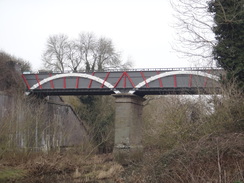
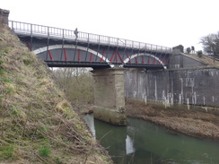
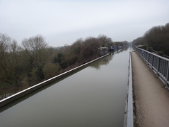
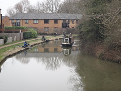
A good riverside path led on, passing under a viaduct carrying the A5, and on to the highlight of the day: the Iron Trunk aqueduct, which carries the Grand Union Canal over the river. It is actually the second bridge on the site; the original brick one was designed by William Jessop, and collapsed after a few years (although the collapse was not that famed engineer's fault). Technology had rapidly moved on in that few years, and the replacement was the magnificent two-span cast-iron trough that still carries boats over the river. It had evidently been recently painted, and even on this gloomy day the white and red structure shone. A low, narrow tunnel (actually a cattle creep) carried the path under the bridge's abutment, and I nipped up to cross the canal at the top and take in the views.
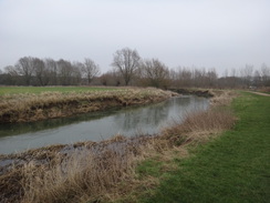
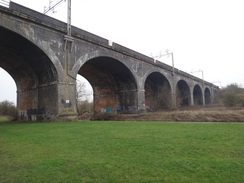
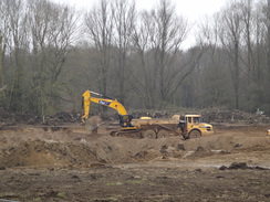
The rest of the journey to Wolverton was fairly uneventful. The canal would have provided a much quicker route to the station, but I was following the Ouse Valley Way, and the riverside path proved to be an attractive and easy walk. A good path led on towards the massive brick viaduct that carries the West Coast Main Line over the river valley, and beyond this diggers and dumper trucks were moving vast quantities of spoil, presumably for another quarrying operation.
I eventually reached the outskirts of Wolverton, and the section of path I had walked last week. Wolverton station was only a short distance away, but my bus left from Milton Keynes, and as there was still plenty of time it seemed sensible to walk the three miles there. Initially I tried following the Midshires Way, but the lack of waymarks and my poor large-scale mapping made that impossible. Instead I followed a dual carriageway into the centre of the city. It was a fairly nondescript stroll, with underpasses making crossing the busy roads easy, and good signage making navigation easy. Soon I was passing a series of large commercial units, and then some very large office buildings right beside the railway and bus stations.
I nipped into Greggs to buy some snacks, but there was a queue and the next bus was due in a few minutes. Instead I waited for the X5 bus to Oxford, hoping that the driver would let me on with my mucky boots and trousers. I had carried trainers in my rucksack in case I was too muddy, but the miles of surfaced path and road walking had bashed the worst mud off. Instead I stood and waited, thinking about what had been an enjoyable stroll of two halves. I have only seven and a half miles of walking to complete the western section of the Ouse Valley Way, and I might be able to get that done later this week, life and weather permitting.
 |
 |
|
Directions
This walk starts at the Cornwalls Meadow in the centre of Buckingham at SP69823400, near the Waitrose store. Leave the car park and either follow the access road or head through the shopping centre to reach the High Street, and then turn right along it. Pass a BP garage on the right, and after half a mile, just before the entrance to a sports ground and opposite the entrance to Page Hill Avenue, turn right along a surfaced path that runs between trees. Follow this path as it skirts a rugby field on the left and joins the Ouse Valley Way beside the northern bank of the Great Ouse. When the path curves to the right to follow the river after a third of a mile, continue straight on along a path that heads away from the river. After another sixth of a mile this path ends at a road at SP70563366. Turn left along this road; when it ends at a T-junction continue straight on, passing a school on the right, until the A413 road is reached at SP70803366.
Carefully cross the A413 and head through a gap in the hedge ahead to join a narrow gravel path. Turn left along this path, and after twenty metres turn right through a metal gate to join the towpath of the disused Buckingham canal. After a third of a mile the watered section of canal ends just before a white house. The path squeezes past a fence on the right to emerge out through a gap onto a track beside the house. Cross the track and go through a gate into a field, and follow a fence on the left. After a short distance, go through a bridleway gate sans fence and continue across the field. After another hundred metres, go through another bridleway gate to follow a fence and sparse hedge on the right. At the corner of this field, turn right to cross a stile, and descend some steps to reach the riverbank. Go through a clappergate, and on the other side head on with the river to the right. A hedge and fence on the right lead past Maids Moreton Weir on the right. Continue on, following the field boundary on the right. About twenty metres before a house is reached, turn right through a clapper gate and then turn left to follow the fence and then a wall on the left past the house. The path than goes through a clapper gate beside a field gate to reach the end of a road at SP71723438 beside Old Mill House.
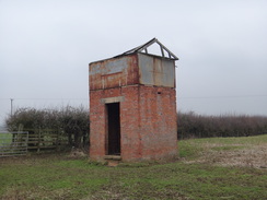
Cross the road, and go through a clapper gate to join a track that follows a hedge on the left, still on the course of the old canal. The track curves gently to the left towards and under some high-voltage power lines, and then passes an area of reeds on the left. When the area of reeds end, go through a farm gate and continue on, following a fence on the left. At the end of this long field, go through a clapper gate and head on, following a fence towards a brick building in a field on the left (a pumping station). Pass the building and head on, with a reservoir on the other sided of the fence. Go through a clapper gate beside a farm gate and head on through Buckingham Canal Nature Reserve, with the dry canal bed to the left. The towpath passes the site of the part-restored Hyde Lane Lock and continues on through trees. It towpath crosses a few small plank footbridges over streams to reach a stile through a fence that leads to a track that bisects the canal. Cross this, and two stiles on the other side, to rejoin the towpath. It leaves the trees and heads on, with the dry canal bed still on the left. Cross a stile and follow a fence on the right; at the end of this field, cross another stile and climb a bank to reach a road at Leckhampsted Wharf House at SP73753578.
Turn right to follow the road for five metres, and then turn left down some steps and go through a clapper gate to enter a paddock. Head straight on through two more gates and pass a barn on the right. As you pass the barn, veer left to follow a hedge on the left and a fence on the right. The path curves to the left and then right to reach a plank footbridge that leads to a clappergate into a field. Angle slightly left, aiming for a stile in a fence ahead. Cross this stile and cross another field, aiming for a distant brick bridge. Cross a second stile into a third field, and head on towards a bridge that carries the A422 over a stream. Before the bridge is reached, turn left over a stile to reach the roadside. Turn right to parallel the A422 for a few metres, crossing a stream using the road bridge at SP74243633.
The path curves to the right away from the A422, and starts following the dry canal channel on the left. Pass through an area of trees to reach a stile that leads into a field, and continue on along the old towpath across the field. Pass an old canal bridge on the left, and half a mile after the A422 road bridge cross a stile to enter a wooded area. Pass an old bridge arch on the left, and climb up some steps to reach a stile that leads onto a road at SP75003650. The trail now leaves the course of the Buckingham Canal.
Turn right and follow this road southeastwards to cross the Great Ouse on a bridge; after a fifth of a mile, turn left across a stile opposite a gateway that leads into Thornton College. The stile leads into a field; angle slightly away from the hedge on the left, aiming for a solitary old tree in the far hedge. Cross a farm footbridge over a ditch near the tree to enter a second field. Head straight on across this field, paralleling the bottom hedge about hundred metres down to the left. The path crests a slight ridge and descends down to meet a footbridge over a stream, beside a large wooden pole carrying power lines. Cross the bridge and go through a clapper gate into a third field. Angle slightly to the right across the field to reach a clappergate that leads into a fourth field. Head straight across this field, with barns uphill to the right, to reach another clappergate that is followed by another gate a couple of metres on. Turn slightly to the right in this fifth field, keeping a church spire ahead and to the right. Cross a plank footbridge over a ditch, and then cross a stile that leads into a sixth field. In this field, turn half-right, aiming for the church. The church boundary fence starts on the left; follow this and descend a slight slope to reach a stile through a hedge that leads onto Thornton Road at SP77043701.
Turn left along the road, passing Beachampton Church on the left. When a triangular junction is reached, take the right-hand fork and then turn right down another road called Main Street to enter the hamlet of Beaachampton; there is a pavement on the right. Pass some houses on the left, and after 150 metres turn left across a plank bridge across a stream, and then cross a stile to enter a field. Follow a fence on the left as the path climbs a slight slope; after about a hundred metres, the fence on the left curves left (there is an old stile here that is easily bypassed). A ditch on the left curves to the left and leads on to a stile. Cross this, and on the other side cross a plank bridge over a ditch, and then angle right for ten metres to another stile. On the other side, cross a farm track to reach another stile, and head up a slight slope to reach a double stile though a thick hedge. Cross the stiles and enter a field.
Head straight on up the field, aiming for a stile beside a field gate about ten metres to the left of two trees. Cross the stile by the gate and angle slightly to the left, aiming for just to the right of the field's corner. Cross two stiles through a hedge into another field, and follow a hedge on the left, with a road on the other side of the hedge. Cross a concrete track that leads up to a farm on the right and continue following the hedge on the left. When the road curves to the left, pass a field gate on the left, then turn left through a clappergate, and then right to follow the hedge on the right away from the road. When the hedge on the right curves away to the right, cross a ditch ahead using a farm bridge and continue on, following the ditch on the left.
As the ditch curves away to the left, join a hedge on the left, and follow this towards a green barn ahead. In the corner of the field a bridleway gate leads through a hedge into another field. Follow the hedge on the left for about ten metres, and then turn left through a gap in the hedge to reach a plank bridge across a ditch that leads into another field. Angle diagonally across the field, aiming for two trees in the far hedge; do not continue towards the green barns. Cross a track running along the side of the field and then a stile to enter another field. Follow a hedge on the left up a slight slope. At the top corner of the field, cross a stile and continue on, with a field boundary on the left, aiming towards a wall ahead. Pass an old brick building in the field on the left, and then squeeze between some tennis courts on the right and a fence on the left for a few metres to reach a stile beside the corner of a brick wall. Cross the stile and follow the wall on the right; when it ends, turn half-left to head diagonally across a rough field, skirting a stream on the right to reach a stile though a hedge that leads onto a road in Calverton at SP78733935.
Turn right and follow the road as it crosses a bridge over the stream and curves to the left; a pavement soon starts on the left-hand side of the road. When a wooden fence ends about twenty metres after the bend, turn left through a gap to join a footpath that follows a stream on the left and a hedge and the road on the right. When the stream curves away to the left, continue following the hedge on the right; eventually the path curves half-left and goes through a gap in a low wooden fence to reach a car park. Cross the car park and go through another low fence to join a concrete path, with the river away to the left. The path curves to the right to cross a footbridge over a stream, and then climbs up slightly. The path is good and obvious to follow; after a quarter of a mile it curves to the left to reach a footbridge over a river stream at SP78534006.
Cross the footbridge, and then turn left along another good footpath towards Stony Stratford Sluice. After a few metres it reaches the sluice and curves right, with the sluice and river channel to the left. When another footbridge over the river is reached on the left, turn right away from it, following another concrete path diagonally across a field towards some converted mill buildings ahead. Cross a concrete track and join a path that leads to the mill buildings. Turn right over a bridge over the old mill leat, passing the mill on the left. Follow a path alongside a road (Willow Lane) on the right; the road and path cross, before they end at a T-junction with Mill Lane at SP78494041.
Turn left along Mill Lane; as it curves to the right after a few metres, continue straight on along a stub road past houses on the right to reach a clappergate that leads into a field. Follow a fence on the left, and continue on past several field boundaries until a clapper gate is reached. Go through this, and in the next field turn half-right, aiming for the far corner of the field. Go through a bridleway gate, and then turn immediately right to reach an adjacent clapper gate. Follow a metal fence on the left for a short distance until High Street in Stony Stratford is reached at SP78344078.
Turn left to follow the road; when it starts to curve to the right, continue straight on along a stub road that meets London Road, which merges in from the right. Carefully cross London Road, and go through a metal gate beside a field gate to enter Stony Stratford Nature Reserve. The concrete path curves to the right to meet the southern bank of the Great Ouse; simply keep to the riverside path, going through any gates that you come across. After half a mile it passes under a viaduct that carries the A5 overhead. Continue along the path as it follows the river; after nearly another half-mile it jinks to the right away from the river to head towards a cattle grid and bridleway gate through a hedge. This leads onto a track that soon ends at a lane leading to an old mill at SP79504109.
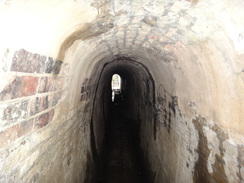
Turn right along this lane for a few metres, and then immediately left to join another concrete path. This follows a hedge on the right before curving to the left and right across grass to reach a footbridge beside a farm bridge over a ditch. Cross the bridge, go through a bridleway gate and continue along the good path on the other side, with the river to the left, going through any gates and crossing any bridges on the way. Two-thirds of a mile after the mill, the concrete path passes rises up and heads through a narrow tunnel under an iron aqueduct that carries the Grand Union Canal overhead. On the other side, simply descend steps back down to the valley floor and continue along the obvious path beside the river. 1.25 miles further on, the track crosses a large arched footbridge over a stream and meets a T-junction with another track at SP81474215.
On the other side of the bridge, turn left to follow another concrete path as it heads eastwards, soon passing under a large viaduct that carries the West Coast railway line overhead. Follow the path, with the river to the left and a car park away to the right; it soon passes under a low bridge carrying Haversham Road, and then curves to the right, still following the river. 0.8 miles after the railway bridge the path crosses a footbridge; as the river and path curve to the left, head straight on along a path past some bushes to reach another path junction. Turn right to follow a path that passes some allotments on the right. As the allotments end and the path curves away to the right, head straight on along another path to reach an access road leading to a car park. Turn left down this road to reach Newport Road in Wolverton at SP82344150. Carefully cross the road and walk west along the pavement on the other side towards Stonebridge roundabout.
Wolverton station is on the other side of the roundabout. However, I continued the walk down to Milton Keynes Central station. Just after a crossing on the road, and before the roundabout, turn left down a surfaced path. Ignore a path that comes in from the right through an underpass, and instead turn left down another path that parallels a road to the right; the path soon curves sharply to the left to cross a bridge over a stream. Immediately after the bridge, take the first path off to the right that runs past some trees on the right to enter New Bradwell Local Park. Do not be tempted onto any paths leading into the housing estate, and continue on as the path roughly parallels the road to the right. By a children's playground, take another path off to the right. Soon afterwards the path skirts the road and approaches a viaduct carrying the Grand Union Canal overhead. Just before the viaduct, turn left along a path that slopes uphill to meet the canal's towpath at SP82924111. Here the Ouse Valley Way is left.
Instead of joining the canal, climb up a grassy slope to the left to reach a footbridge spanning the canal. Cross this, and on the other side cross a little play area on the right to reach a footbridge that spans a dual carriageway called V6 Grafton Street. From here I took a different route; but the following works just as well: do not cross the bridge over the dual carriageway, and instead head down a sloping path that leads to the eastern side of the dual carriageway. Follow the dual carriageway southwards for two miles; there are underpasses under the three major roundabouts that are encountered. When Midsummer Boulevard is reached at SP84423819, turn right to follow the boulevard a short distance to Milton Keynes Central rail and bus stations. Although these miles are along roads, the paths are good, with most junctions having underpasses that allow you to safely negotiate them. This walk ends at Milton Keynes Central rail station at SP84193806.
 |
 |
|
Distances
| From | To | Distance (m) | Ascent (ft) | Descent (ft) |
|---|---|---|---|---|
| Buckingham | Thornton | 4.8 | 89 | 112 |
| Thornton | Stony Stratford | 5.1 | 151 | 171 |
| Stony Stratford | Wolverton | 4.0 | 85 | 92 |
| Wolverton | Milton Keynes Central station | 3.2 | 180 | 112 |
This makes a total distance of 17.1 miles, with 505 feet of ascent and 487 feet of descent.
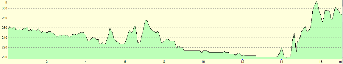
For more information on profiles, ascents and descents, see this page
 |
 |
|
Transport
Stagecoach X5 services run every half-hour between Milton Keynes and Buckingham, on the Cambridge to Oxford route.
If you end the walk at Wolverton, then regular train services run from Wolverton station to Milton Keynes Central, where the X5 can be caught on to wards Buckingham.
 |
 |
|
 |
 |
|
 |
 |
|
 |
 |
|
 |
 |
|
 |
 |
|
 |
 |
|
 |
 |
|
 |
 |
|
 |
Disclaimer
Please note that I take no responsibility for anything that may happen when following these directions. If you intend to follow this route, then please use the relevant maps and check the route out before you go out. As always when walking, use common sense and you should be fine.
If you find any information on any of these routes that is inaccurate, or you wish to add anything, then please email me.
All images on this site are © of the author. Any reproduction, retransmissions, or republication of all or part of any document found on this site is expressly prohibited, unless the author has explicitly granted its prior written consent to so reproduce, retransmit, or republish the material. All other rights reserved.
Although this site includes links providing convenient direct access to other Internet sites, I do not endorse, approve, certify or make warranties or representations as to the accuracy of the information on these sites.
And finally, enjoy your walking!
Nearby walks
| # | Title | Walk length (miles) |
|---|---|---|
| 143 | Cheddington Station to Bletchley Station | 13.3 |
| 146 | Bletchley to Wolverton | 11.9 |
| 157 | Wolverton to Bugbrooke | 16.6 |
|
|

|