Walk #146: Bletchley to Wolverton
 |
 |
|
General Data
| Date Walked | 11/08/2001 |
| County | Buckinghamshire |
| Start Location | Bletchley Station |
| End Location | Wolverton Station |
| Start time | 09.38 |
| End time | 13.55 |
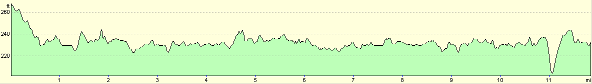
| Distance | 11.9 miles |
| Description | This was a pleasant walk following the Grand Union Canal northwards though the city of Milton Keynes. |
| Pack | I did not carry a rucksack today. |
| Condition | My ankle is aching slightly, but my legs, back and shoulders are fine, which is to be expected after a relatively short walk with no pack. |
| Weather | The weather today was mainly thin cloud, with occasional spitting rain which was not enough to get me wet but enough to force me to keep my coat on. The temperature was quite high, but the light drizzle and a strong wind helped me keep cool without getting cold. |
| OS map | Landranger number 152 (Northampton & Milton Keynes) |
 |
Map of the walk
Maps courtesy of Google Maps. Route for indicative purposes only, and may have been plotted after the walk. Please let me have comments on what you think of this new format. For a detailed table of timings for this walk, please see the table file.
Notes
This was a very enjoyable walk across the centre of Milton Keynes, an area which I had not been looking forward to crossing. Fortunately most of the views were typical canalside views, with only occasional glimpses of the city being visible. The towpath was quite good through the whole walk, and was at the very least a gravel path underfoot. For a long section there was a tarmac or concrete cycle path which paralleled the canal towpath which could be used as an easier (but less scenic) alternative to the towpath.
The main aim of this walk was to give myself some nice, non-stressful exercise before I head off to Scotland on Friday next week. As such it was successful, as I have strengthened up my legs slightly without causing myself any injury, fatigue or blisters.
I took no pack with me today, and wore my coat (which was a good job because it spat with rain for a majority of the walk), and consequently I did not take any water with me. After a couple of hours I was feeling thirsty, so I stopped for twenty minutes in a Brewers Fayre pub and had a pint of coke and a pack of prawn cocktail crisps. Unfortunately I finished the coke before the prawn cocktail crisps, and so I had a dry mouth for the rest of the walk, except this time it was a dry mouth with a prawn cocktail taste. The pub was very quiet and seemed to have no soul, despite being very tidy. This seems to be a problem with these chain pubs, and I must admit that I prefer small free houses to the chain-owned pubs.
The initial part of the walk was from the station at Bletchley to the canal. I was not too bothered about getting back to the canal at Water Eaton Bridge where I had left it on the previous walk, so I headed northeastwards from the station. Unfortunately I soon became a victim of Milton Keynes infamous road system, and as some of the roads that I had intended to ue did not have pavements I had to cut through some housing estates. Unfortunately I had left my compass at home, and so I got slightly disoriented whlst going through the estates and ended up at Water Eaton bridge anyway. This was ever so slightly embarrassing, but it did not really matter on such a short walk.
There are currently plans to build a brand new canal between Milton Keynes and Bedford, which will hopefully be completed by 2010. More details can be seen on The Bedford to Milton Keynes waterway link website. This will allow boats to travel between the Great Ouse and the Grand Union Canal without having to go further north towards Leicester and will therefore link the canal systems of the Wash with the inland waterways. The link should be about seventeen miles long, and if made as a broad canal should cost between �60 to �80 million. The canal will start (or end) near Fenny Stratford Lock in Milton Keynes, and will have some major engineering challenges such as the crossing of the M1 motorway.
I am now just under halfway on my canal walk between London and Birmingham; this is not as far as I had hoped to get after this time as most of the walks so far have been fairly short. With luck after the next walk I should be over the halfway mark, and from there Gas Street Basin in Birmingham should be firmly in my sights.
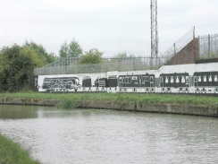
Just before Wolverton station is reached there was a lovely black-on-white mural on the wall on the opposite side of the canal. It was probably about a hundred yards long, and feature one of the weirdest railway trains that I have ever seen, with diesels, steam and even rockets powering the thing. It was a lovely mural, and was being repainted by the Inland Waterways Association as I passed it.
My next walk along the Grand Union Canal could take me further north towards Blisworth or Bugbrooke, or alternatively I may do the end of the walk and walk from Kingswood into the centre of Birmingham. Both of these walks would be about seventeen miles long, and so will probably have to wait until I have finished the next section of my Land's End to John O'Groats walk which takes a priority.
Milton Keynes is fairly infamous as being a 'boring' place, an image which is not helped by the comical concrete cows which the area is famed for. The canal threads itself along the eastern and northern edges of the city, mostly through some of the old villages that existed before the city was founded and therefore misses the very centre of the town. Near Giffard Park the canal comes into close proximity of the M1 motorway, and although I could hear the roar of the cars in the distance I never actually get to see them.
All in all this was a nice walk which sets me up well to finish my walk along the Grand Union Canal before the end of this year.
Directions
The directions for this walk are fairly simple as long as you can actually get to the canal in the first place, a task that I appeared to find beyond my skills. One set of directions would be to follow in reverse the directions shown in the last walk along the canal, but I chose to try and cut across to Fenny Stratford Lock. This failed quite spectacularly, so I suggest that you follow the earlier instructions.
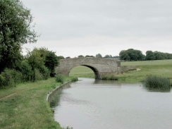
Once you reach Water Eaton Bridge turn left and join the towpath as it starts to wind its way northwards. After a mile you pass under the Bedford to Bletchley railway line and then come across Fenny Stratford Lock, which is the only lock on this walk (comparing well with other walks which had many). Continue past the lock as it passes under some major road bridges, including that of the A5(T), to reach the little village of Simpson.
The canal then passes under the A421 before continuing through Woolstone and under the A509 to reach Downhead Park and Willhead. Pass under Bridge 79a which carries the A422 Monks Way and continue on to bridge 78, beyond which is The Gifford Park pub. Here the canal starts to move away from its northerly heading to a westerly one, passing the old junction with the long-abandoned Newport Pagnell arm of the canal in the process.
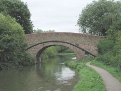
The canal soon passes under an old railway bridge (which is now a footpath) before it becomes more rural. A sharp-left hand turn causes the canal to head south for a short period before passing under a road bridge and heading southwestwards. A modern concrete aquaduct leads over the V6 dual carriageway road before the canal passes under the railway line and turns to a northerly heading. As it turns a pretty mural of a train is visible on a wall on the opposite side of the canal. Continue on to the next bridge (Wolverton bridge, number 71), and turn right to climb up some steps to the top of the road bridge. Turn left onto the road and follow it for a very short distance down the hill and to Wolverton Railway station.
Further information
|
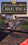
The walk is also covered in detail in the Grand Union Canal Walk, by Anthony Burton and Neil Curtis, ISBN 1 85410 244 3, published by Aurum Press Ltd. Click on the image to the right to go the Amazon page for this book.
For more details on the Grand Union Canal see Jim Shead's canal pages. |
|
Distances
| From | To | Distance (m) | Ascent (ft) | Descent (ft) |
|---|---|---|---|---|
| Bletchley Station | Willen Road Bridge | 7.8 | 200 | 230 |
| Willen Road Bridge | Wolverton Station | 4.1 | 121 | 128 |
This makes a total distance of 11.9 miles, with 321 feet of ascent and 358 feet of descent.
For more information on profiles, ascents and descents, see this page
Transport
There are regular train services between Wolverton and Bletchley Stations, as well as bus services between the two stations. See the Railtrack website for more details of the train services.
Disclaimer
Please note that I take no responsibility for anything that may happen when following these directions. If you intend to follow this route, then please use the relevant maps and check the route out before you go out. As always when walking, use common sense and you should be fine.
If you find any information on any of these routes that is inaccurate, or you wish to add anything, then please email me.
All images on this site are © of the author. Any reproduction, retransmissions, or republication of all or part of any document found on this site is expressly prohibited, unless the author has explicitly granted its prior written consent to so reproduce, retransmit, or republish the material. All other rights reserved.
Although this site includes links providing convenient direct access to other Internet sites, I do not endorse, approve, certify or make warranties or representations as to the accuracy of the information on these sites.
And finally, enjoy your walking!
This walk was mentioned in the following routes:
| Grand Union Canal Walk |
Nearby walks
| # | Title | Walk length (miles) |
|---|---|---|
| 143 | Cheddington Station to Bletchley Station | 13.3 |
| 157 | Wolverton to Bugbrooke | 16.6 |
| 612 | A circular walk from Buckingham to Silverstone | 18.8 |
|
|

|