Walk #1022: Burslem to Nantwich via Longport, Alsager and Crewe
 |
 |
|
General Data
| Date Walked | 22/10/2018 |
| County | Staffordshire, Cheshire |
| Start Location | Burslem Chapel Lane car park |
| End Location | Nantwich station |
| Start time | 07.39 |
| End time | 14.17 |
| Distance | 21.1 miles |
| Description | This was a fairly uninteresting stroll west to Cheshire, the highlight being the early stretch along the Trent and Mersey canal, and especially the Harecastle Tunnel. |
| Pack | Today I carried my 30-litre Karrimor rucksack, filled with water, my spare waterproofs, a book and other odds and ends. |
| Condition | I feel absolutely fine after this walk. |
| Weather | Today was bright and sunny, albeit with a bit of a breeze. |
| OS map | Landranger number 118 (Stoke-on-Trent & Macclesfield) |
 |
 |
|
Map of the walk
Maps courtesy of Google Maps. Route for indicative purposes only, and may have been plotted after the walk. Please let me have comments on what you think of this new format. For a detailed table of timings for this walk, please see the table file.
 |
 |
|
Notes
My parents have volunteered to look after Robert for a few days during half term, and so I decided to get some walks done in their local area. Earlier in the year I walked between Nantwich and Chester, connecting the town to the sea just over the Welsh border. Many years ago I walked to Longport in Stoke on Trent, and there was a gap between there and Nantwich that, if walked, would complete a walk across the country from Boston on the east coast to Chester and the River Dee in the west.
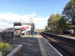
There did not seem to be any parking near Longport station, so I parked in the town of Burslem instead. I got a little lost in the town, and had to rely on Google Maps to show me the road that led down towards Longport station. It proved a longer walk than expected, not the least because the map shows I took a wrong turn and ended up doing a bit of a loop!
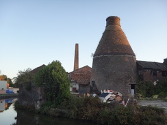
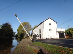
I eventually found my way down to the station, where I had finished a previous walk, and continued on to the Trent and Mersey canal. A bottle kiln sat alongside the canal, a sight that would have been a common sight fifty or more years ago, but are now a bit of a rarity. The kiln was attached to some shabby-looking industrial buildings, the sort that are all too quickly disappearing from our waterways as redevelopments occur. These buildings were part of the Top Bridge Works.
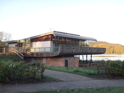
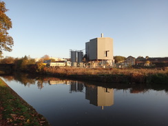
The canal led pat Westport Lake (once the site of Port Vale's football ground, presumably before it flooded), which had a rather intriguing visitor's centre, with a wooden curved structure slightly reminiscent of a ship's hull, with part of it supported in mid-air by posts. The centre opened in 1972, and seems like a pleasant green oasis in the middle of the city, at least when viewed from the canal. I eschewed the delights of the visitors centre and headed along the arrow-straight canal through what was once a highly industrialised area. Some industry remained – for instance a tarmac plant – although most of the surroundings remained hidden from view.
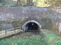
Soon the eastern portal of Harecastle tunnel was reached. A boat was just entering the tunnel's rather ugly brick portal, too soon to allow me to get a good picture. There are actually two canal tunnels: the first, designed by Brindley (who sadly died before completion), opened in 1777. This tunnel soon reached capacity, and a second, designed by Telford, opened in 1827. The latter tunnel included a towpath that was later removed - this perhaps explains why there is no alternative pedestrian route over the top of the hill. Subsidence meant that the Brindley tunnel closed in 1914, and the Telford tunnel also suffered from similar problems that had to be rectified in the 1970s. Unusually, the Teford tunnel has a series of other underground canals coming off it that provided access to mines.
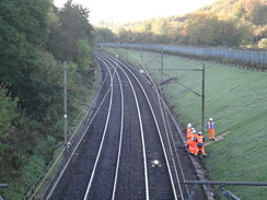
I climbed up onto the road above the tunnel portal, and followed it northwestwards past a massive but not unattractive JCB building. This led to a path that led into some woodland, passing under a railway line to reach a lake called Bath Pool. Some men were working in the deep railway cutting, and another was using two short ladders on the wet grass to join them.
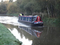
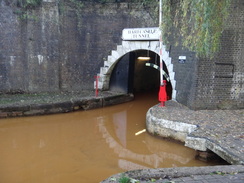
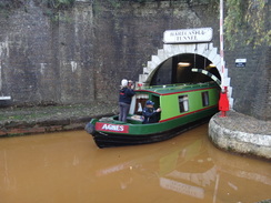
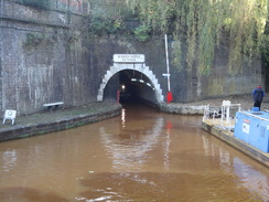
This path led back to a road, and later another took me on to the tunnels' western portals. The path headed over the portal of the original Brindley tunnel, whilst a steady stream of boats came out of the Telford tunnel – perhaps including the one I had earlier seen enter the eastern portal. The water emerging from the tunnel is a rich orange colour, a result of minerals leaking into the canal from the disused mines. It is so discoloured that it seems incredible that anything might live in it, or that anyone might drink it without some drastic treatment.
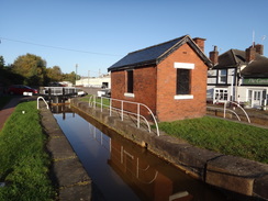
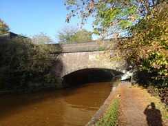
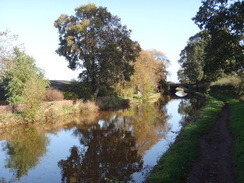
A pleasant stroll along the canal followed. A junction was soon reached, with the Macclesfield canal turning off to the south – oddly, as the canal heads northwards. This problem was soon solved as a massively-built aqueduct took the Macclesfield Canal overhead. A series of locks followed, and all aside from one were double locks, an indication of how busy this stretch of canal had been before the railway age had begun.
I want to walk the Trent and Mersey canal in its entirety sometime (after all, I was born within a stone's throw of it), and I feel slightly sad that I have yet to do so. But it would require more than a week's walking, and there are so many other walks that I would like to do, especially as I have already done some of the Trent and Mersey piecemeal. It shall sadly have to wait.
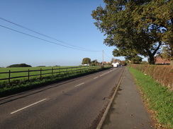
The canal starts heading northwestwards from Kidsgrove, whilst my route headed west. I swapped towpath for road, and there was not much to note as I headed through Church Lawton and Alsager, aside from a quick stop at a supermarket to buy some snacks. It was a fairly uninteresting plod, and I just put my head down and walked. The suburban area was eventually left behind, and after passing under the M6 country roads took me northwestwards, before paths led west into Haslington. On the way I passed Haslington Hall, which was a fairly magnificent timber-framed building. Unfortunately it also appeared rather unkempt as a result of a sad fire back in April. I can only hope it is fully rebuilt in all its glory.
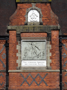
An old school in Haslington had a rather elegant stone above its entrance, engraved with the words "Time rewarding industry and punishing sloth", and I wondered how many children ever paid heed to the message. From Haslington, roads took me west from the village towards Crewe, with a large roundabout that was nearing the end of a remodelling. I could have chosen a direct route towards Crewe station, but instead I chose another route slightly to the north, which eventually crossed bridges over two railway lines, carrying two of the six routes that converge in Crewe. After this a diversion led to the Crewe Heritage Centre, which as expected for a midweek was shut. However the reason I made the diversion was visible from the road, albeit behind a fence.
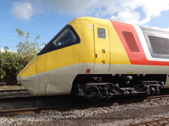
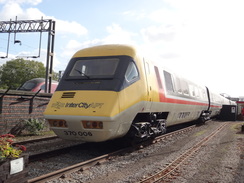
The APT-P was a tilting train that was developed from the 1960s to the early 1980s, and for the time was a world-beater. However the project was probably too adventurous, and a series of technical problems caused BR and the government to lose faith in the project. Of the three prototype trains, only the one in the heritage centre remains. It is a train I love, and a sign of what could have been. In my opinion it is still futuristic-looking, and would not look out of place on the network today. As if to highlight the missed opportunity, a Pendolino train passed on the adjacent railway line. These tilting trains were introduced in 2002, and were made in Italy. Somewhat annoyingly, they use some of the technology developed by the APT project.
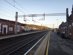
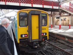
Roads led towards the centre of the town, and I decided not to visit the railway station, where I could have finished the day's walk. Instead, a long road walk took me southwestwards towards Nantwich. Again there was little to note on this stretch, and the miles flew by as I strode along. I was hungry by the time I reached Nantwich station, and as I had nearly an hour until the next train, I headed to a Morrisons to buy some sandwiches which I scoffed down as I waited for my train. This took me to Crewe, where I had another long wait for a train back to Longport, so I spent some time exploring the station. Once at Longport, I faced the walk uphill back to my car in the centre of Burslem.
Aside from the early stretch along the canal and seeing the APT-P it had been a rather boring walk, whose only real purpose was to fill in a gap in the map of my walks. Hopefully the next couple of walks will be more interesting.
 |
 |
|
Directions
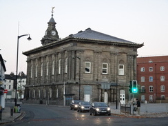
This walk starts at the Chapel Lane car park in Burslem at SJ87074984. Leave the car park and, as you face up the slight slope, take the road to the right, Doulton Street, which soon ends at the B5051 Moorland Road. Turn left along Moorland Road, and when a large crossroads is reached before the Town Hall, turn left along Swan Square. Take the third road off to the right, Pitt Street West, and follow this as it curves right, becoming Cross Hill, and then curves left past a church on the left. The road then curves right to climb, becoming Woodbank Street, which soon ends at a roundabout. Take the first exit off to the left, the B5051 Newcastle Street, and follow it as it heads downhill, slowly curving to the right. After 850 metres a roundabout with the A5271 is reached; turn left along this road. After nearly 200 metres it crosses the Trent and Mersey canal on a bridge. Shortly afterwards veer right down Station Street, which soon reaches Longport railway station at SJ85574943.
Turn back up Station Street back to its junction with the A5271, and turn left along the road for a short distance until Canal Street leads off to the left, immediately before the canal bridge. Turn left down this road, and immediately turn right to join the towpath of the Trent and Mersey canal. Turn left along the towpath, keeping the water on the right. Follow the canal as it heads north-northwestwards for 2.3km until a footbridge over the canal (number 130) is reached at SJ84955159.
Cross the footbridge, which is a short distance away from the eastern portal of Harecastle Tunnel. On the other side, turn left along a path that climbs up, with the canal down to the left. At the top go past a vehicle barrier to join Chatterly Road. Turn left along the road for a short distance to a roundabout, and then turn left along Lowlands Road. This gently curves to the right, passing a JCB factory on the left, and 700 metres after the roundabout curves left. On this left-hand bend, turn right down an access road and under a vehicle barrier to reach Bathpool car park at SJ84175200.
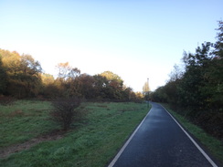
Head through the car park, and at the far end join a surfaced path that heads through a park. It curves left to head under a railway bridge, and then right to head north, with the railway line directly to the right. As the path reaches the southern end of Bath Pool lake, turn right along a path that heads a few metres towards the railway line, and then left to run between the lake on the left and the railway on the right. At the northern end of the lake, turn right to cross a footbridge over the railway, and on the other side turn left along a path that runs through trees. It then curves right away from the railway, and after 300 metres reaches another car park at SJ84035346.
Head through the car park, and at its far end go under a vehicle barrier to join an access road. Turn right along this road for a short distance until it ends at a T-junction with Nelson Bank. Turn left along this road, ignoring another that angles off to the right, and follow it as it immediately curves left to become Boathouse Road. This passes a housing estate off to the right. After 550 metres this road ends at a T-junction on a bend; turn right down The Avenue, and carefully cross to the left-hand side of the road. After about fifty metres, turn left up a gravel path, and after ten metres turn right along a wide path that runs between low walls. This passes over the northern portal of the Old Harecastle Tunnel, before curving right to rejoin the Trent and Mersey canal towpath beside the western portal of the New Harecastle Tunnel at SJ83725417.
Turn left to follow the canal northwestwards away from the tunnel. It crosses a towpath bridge over the entrance to the Macclesfield Canal, and a short distance further on reaches Lock 41. Turn right to cross the bridge in front of the lock, and on the other side turn left, to follow the towpath which is now on the northern side of the canal. It continues on, passing another lock and then heading under a large aqueduct that carries the Macclesfield Canal overhead. Follow the canal westwards as it passes a series of locks; 1km after the aqueduct, it slowly curves right to take a more northerly course, and after another half-kilometre reaches bridge 135 which carries the A50 overhead at SJ81965559.
Immediately before the bridge, turn right to head up some steps that lead onto the top of the bridge, and then turn left to follow the road as it crosses the canal. Follow the A50 westwards for 1.1km until it ends at a busy crossroads with the A5011. Carefully cross the A5011, and head on westwards along the B5077 as it heads through Alsager. 4.2km after the crossroads the road passes under the M6, and 200 metres after the motorway, turn right along another road, Nursery Road, at SJ76935427.
Nursery Road heads north-northwestwards; after 270 metres the road ends at a T-junction in front of some houses. At the junction, turn left to head straight on. The road immediately curves left to head westwards, passing houses on the right. It takes a westerly course, and after 620 metres turns sharply to the right to head northwards, and later northwestwards, becoming Holmshaw Lane. Continue along the road for 2.1km after the sharp bend, until shortly before Barnfields Farm is reached, where a surfaced driveway to Haslington Hall leads off to the left at SJ74925609.
Head down towards the Hall, passing a lake on the left, and just before the hall is reached, turn right along another track that passes a house on the right. Cross a cattle grid, and immediately on the other side turn left across a stile into a field. Angle across this field slightly to join a track on the right. At the southern end of the field, go through a stile beside a farm gate and continue along he track alongside a hedge on the left. When the track curves left through the hedge on the left, continue straight on to squeeze past a farm gate at SJ74605566.
This leads into a field; continue following the hedge on the left. At the end of this field, go through a clapper gate and continue past another field, still with the hedge still on the left. At the far corner of this field, go through another clapper gate and angle right, continuing to follow a hedge on the left. The hedge winds around slightly, and a stream joins on the other side to reach a pedestrian gate beside a field gate. Go through this into another field; follow a hedge on the right up. At the end of this field, go through a clapper gate beside a field gate to join a track. The track immediately curves left and ends at a road to the south of Haslington at SJ74165545.
Turn right along the road and follow it as it heads west into Haslington. After 500 metres it ends at a T-junction with Crewe Road. Turn left along Crewe Road, and follow it as it curves right to head westwards. Follow the road as it heads through and out of the village, and after 1.3km it reaches a large roundabout with several roads, including the A534 and A5020 roads at SJ72385541.
This roundabout was in the process of being altered as I walked past, but you need to aim for the third major exit counter-clockwise, Hungerford Road – take care on what is a large and busy roundabout. Follow this road westwards into Crewe; after 1.1km it climbs to cross a bridge over a railway line, after which it curves left to reach a roundabout. Take the second exit to head straight on along the road, passing a retail estate on the left. The road climbs to cross a second rail bridge and immediately ends at another roundabout. Turn left to take the first exit, the A5019, and follow this south with a railway line on the left to reach another roundabout at SJ70825553.
If you want to visit the Crewe Heritage Centre, where the APT-P can be viewed even through a fence if the centre is closed, then take the first exit off the roundabout to continue alongside the railway line. If not, follow the route described next. At this roundabout, take the second exit along a road that gently curves right, with a large Tesco store on the left. This road soon ends at another roundabout. Take the first exit to the left, Mill Street, and follow it as it immediately heads under a rail bridge. Follow this road south for 630 metres until it ends at a crossroads with the A534 at SJ70735472, with Crewe railway station away to the left.
Turn right to head west down the A534. Continue along the road as it heads through and out of Crewe; after 4.5km it reaches a roundabout with the A51. Carefully cross the roundabout to head straight on down Crewe Road, soon passing a pub and a Premier Inn on the right. The road enters the outskirts of Nantwich; after 1.4km it reaches a small roundabout with the B5074. Turn left down this road for a few metres to a second roundabout, and then right along Hospital Street. At another roundabout, turn left down Pratchetts Row; this passes the car park for a Morrisons on the right, and then curves right, becoming Station Road. This passes between a Morrisons store and an Aldi, until another roundabout is reached. Take the first road off to the left, to head south for a short distance until Nantwich railway station is reached on the left at SJ65265191.
 |
 |
|
Distances
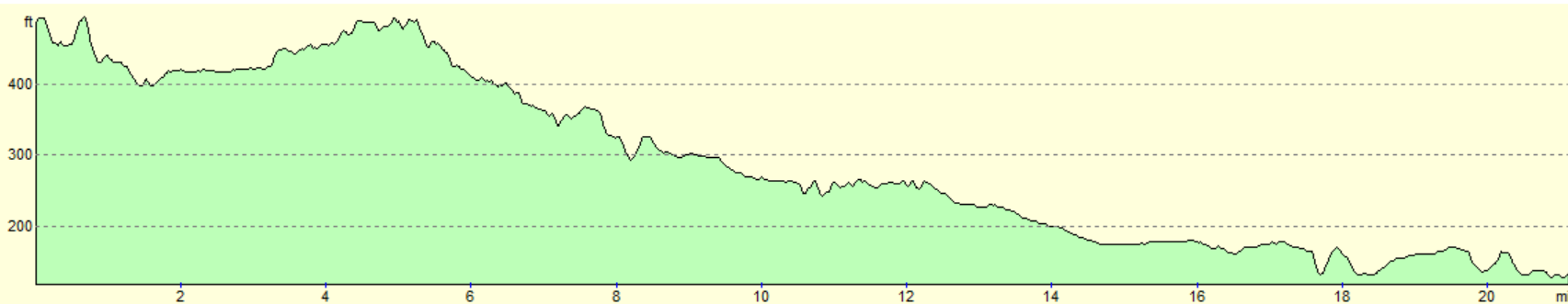
| From | To | Distance (m) | Ascent (ft) | Descent (ft) |
|---|---|---|---|---|
| Burslem | Longport station | 1.5 | 66 | 167 |
| Longport station | Harecastle tunnel western portal | 4.0 | 138 | 141 |
| Harecastle tunnel western portal | M6 | 5.3 | 69 | 217 |
| M6 | Crewe | 5.1 | 66 | 125 |
| Crewe | Nantwich station | 5.2 | 157 | 210 |
This makes a total distance of 21.1 miles, with 496 feet of ascent and 860 feet of descent.
For more information on profiles, ascents and descents, see this page
Transport
You can get between Nantwich and Longport stations by train, with a change at Crewe. See the National Rail Enquiries website for more details.
After that, it is a 1.5 mile walk uphill back to Burslem town centre.
 |
 |
|
 |
 |
|
 |
 |
|
 |
 |
|
 |
 |
|
 |
 |
|
 |
 |
|
 |
 |
|
 |
 |
|
 |
Disclaimer
Please note that I take no responsibility for anything that may happen when following these directions. If you intend to follow this route, then please use the relevant maps and check the route out before you go out. As always when walking, use common sense and you should be fine.
If you find any information on any of these routes that is inaccurate, or you wish to add anything, then please email me.
All images on this site are © of the author. Any reproduction, retransmissions, or republication of all or part of any document found on this site is expressly prohibited, unless the author has explicitly granted its prior written consent to so reproduce, retransmit, or republish the material. All other rights reserved.
Although this site includes links providing convenient direct access to other Internet sites, I do not endorse, approve, certify or make warranties or representations as to the accuracy of the information on these sites.
And finally, enjoy your walking!
Nearby walks
| # | Title | Walk length (miles) |
|---|---|---|
| 584 | Doveridge to Longport | 21.7 |
| 648 | Kidsgrove to Macclesfield | 18.6 |
| 650 | A circular walk from Cheddleton to Rudyard Lake | 17.4 |
|
|

|