Walk #648: Kidsgrove to Macclesfield
 |
 |
|
General Data
| Date Walked | 18/02/2005 |
| County | Staffordshire, Cheshire |
| Start Location | Kidsgrove |
| End Location | Macclesfield station |
| Start time | 08.40 |
| End time | 14.56 |
| Distance | 18.6 miles |
| Description | This was a quite nice canal side walk, with plenty of variety in the terrain that I traversed. |
| Pack | Today I carried my 30-litre Karrimor rucksack, filled with my usual set of detritus and kit. |
| Condition | I was fairly concerned about today's walk after the pain that I had suffered on last Saturday's walk. The pain had continued intermittently into this week, and so I was relieved when I reached the end of this walk with no repetition of the sharp, stabbing pains that I had suffered. The only problems that I did have were with my feet, which were aching by the end of the day. |
| Weather | Fairly soon after I set off it startled to drizzle, and because it was not a cold day I did not bother to put my coat on and let my fleece soak the moisture up. Unfortunately by the time that I reached the Bosley Locks it was raining fiercely, so I sheltered under a bridge and changed out of my soaked fleece into me coat. The rain continued for about an hour, after which a keen wind picked up that helped to dry me off. The sun did make some appearances in the afternoon, but these were neither long nor particularly useful. |
| OS map | Landranger number 118 (Stoke-on-Trent & Macclesfield) |
 |
 |
|
 |
 |
|
Map of the walk
Maps courtesy of Google Maps. Route for indicative purposes only, and may have been plotted after the walk. Please let me have comments on what you think of this new format. For a detailed table of timings for this walk, please see the table file.
Notes
This walk is part of a route that I had been planning to walk up into Manchester, and I was quite keen to at least get the walk started. The holiday year at the place I work finishes at the end of April, and as I have over thirteen days left I decided to take a couple of days off to make a long weekend. I stayed at my parents' house in Doveridge last night, and early this morning drove up to the start of the walk at Kidsgrove railway station. The drive did not go very well; there were some long roadworks on the A500 through Stoke (where it looks as though the entire road is being widened), and then when I finally reached Kidsgrove I could not find the road leading down to the railway station. After literally driving around the block I finally pulled into the station car park, got my pack on and walked into the station to enquire about train times.
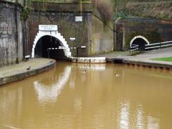
Usually if I am planning to do a walk that requires travel by train or busses I research the train times on the web. I neglected to do it on this walk, and I therefore got a nasty surprise when I discovered that there are only a couple of trains a day running direct between Kidsgrove and Macclesfield. This meant that the return journey would be much longer as I would have to change at Stoke-on-Trent station. I therefore set off on the walk in a slightly deflated mood, which did not last long as I found a path that led straight from the station car park down to the towpath of the Trent and Mersey canal. Instead of heading off on the walk I made a slight diversion in the opposite direction to reach the western portals of the Harecastle Tunnels; with the smaller one on the left and the larger, newer one on the right. These are quite an impressive sight and were worth the hundred yards diversion to see them.
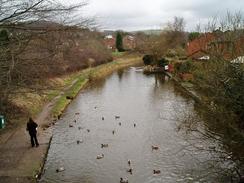
I did not have to walk along the Trent and Mersey canal for far, as immediately before the first lock the Macclesfield Canal headed off to the left. Initially this went round a sharp couple of bends before crossing over the Trent and Mersey canal on a bridge; the latter having dropped in level due to the lock. Immediately I discovered that the towpath of the Macclesfield Canal was going to be muddy, and within half a mile my waterproof trousers were brown from the knees down. The waters of the canal for this first stretch were an unusual brown-orange colour, which was not a particularly sight and must be the result of chemicals in the local soil leaching into the water. This soon faded away as I headed north and away from the Potteries, and soon the water was the usual colour for canal water.
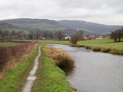
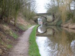
The miles seemed to trip lightly off my boots as I followed the towpath northwards, passing the curiously-named Scholar Green before eventually reaching the outskirts of Congleton. Here the towpath switched over to run along the eastern side of the canal for a quarter of a mile before swapping back to the western side; the bridges that took the towpath across the canal being of an unusual and strangely elegant semi-spiral design. I did not get to see much of Congleton as the canal bypassed the centre of the town and went through a cutting; I will have to do another walk sometime to take a look at this town. From here the canal started to take a more easterly course, and the drizzle that had been falling for an hour started to get heavier. I had not yet put my coat on, and I was loathed to do so, so I let my fleece soak up the rain. However by the time that I reached the bottom lock of the Boswell flight the rain had become relatively fierce, and so I sheltered under a bridge whilst I took my fleece off and my coat on, The bridge turned out to be a railway bridge on the old North Staffordshire line from Uttoxeter to Macclesfield, the junction with the still-extant main line being a short distance away at North Rode. The embankment and bridges that I could see seemed to be in good condition, a dramatic difference to the line near Uttoxeter, which has been virtually obliterated by new roads and development.
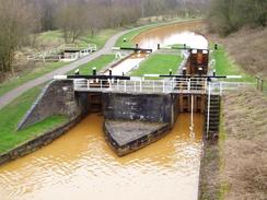
The locks on the Bosley flight were quite nice, and I was annoyed that the low cloud and rain prevented me from seeing the hills of the western side of the Peak District off to my right or the summit of The Cloud to the south (which, accurately enough, was obscured by cloud). One shirt stretch of canal between two of the locks had been dewatered to allow repairs on a lock, and a couple of workmen were sheltering from the rain under a bridge when I arrived. I always find dewatered stretches of canal to be fascinating as it allows me to see the underlying structure of the canal, something that is normally hidden from view. The canal started to run parallel to the A523(T) as it headed northwards, and at Oakgrove I saw an easily-accessible pub on the other side of a swing bridge that unusually carried motorised traffic. It was extremely tempting to go in for a pint and a rest, but as had been the case on the last few walks my muddy condition precluded the option. Instead I walked on, and after about half a mile I came across a pedestrian footbridge over the canal. I used this as a seat, and rested me tired feet for ten minutes before getting up and continuing on for the rest of the walk.
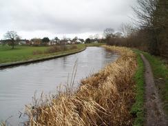
As the canal headed north the sun started to come out and the hills started to encroach to the east. I actually enjoyed this stretch of the walk despite the fact that the canal was slowly leaving countryside and entering suburbia; despite running though a town the canal provided a nice green corridor. I was feeling fairly fit and I had plenty of time before the next train, so instead of taking the first road that headed back towards the railway station in Macclesfield I walked on until I reached the B5470, and then walked down this towards the town centre. By this time I was feeling quite peckish, and as I had not eaten anything since breakfast I nipped into a little shop and bought myself some chocolate and a packet of crisps to tide me over until dinner. When I got to the station in the town I ended up walking down the wrong side; I could clearly see the platforms but I had to divert back a short distance to a road under the railway line to access the station. I was fairly relieved when I reached the station and the end of the walk as my feet had started aching once again, but as I stood in the vestibule of the Pendelino to Stoke-on-Trent I could look back on a walk that, whilst not being a classic, had nonetheless been enjoyable.
Directions
This walk starts at the car park at Macclesfield Station. Leave the car park, not by the road but by a little path that leads off to the left as you face the entrance to the station. This path squeezes between two fences before descending down some steps to the towpath of the Trent and Mersey Canal. Once on the towpath turn left and follow the canal as it heads under a bridge until a bridge is reached at a canal junction. Do not cross the bridge but turn left to start walking along the Macclesfield Canal. This canal immediately turns sharply to the right to run parallel to the Trent and Mersey Canal, before turning right once more to cross the latter canal and head northwards.
The rest of the day's walking is fairly straightforward; just follow the Trent and Mersey Canal as it heads northwards, skirting past Congleton before reaching Macclesfield. Here I followed the canal until I reached Bridge 34 at SJ930744; here I left the canal and joined the B5470 road that runs across the bridge. Turn left and follow the B5470 as it heads downhill southwestwards, eventually entering the centre of Macclesfield. When the road meets the A523(T) turn left to follow the latter southwards for a short distance until the junction with the A537 is reached on the left. Here turn right to pass under a railway bridge, and Macclesfield Station is immediately on the left.
Distances
| From | To | Distance (m) | Ascent (ft) | Descent (ft) |
|---|---|---|---|---|
| Kidsgrove Station | Congleton Station | 6.4 | 282 | 279 |
| Congleton Station | Bosley Bottom Lock | 5.0 | 499 | 427 |
| Bosley Bottom Lock | Macclesfield Station | 7.2 | 325 | 397 |
This makes a total distance of 18.6 miles, with 1106 feet of ascent and 1103 feet of descent.
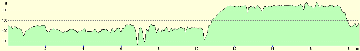
For more information on profiles, ascents and descents, see this page
Transport
There are very infrequent railway services between Macclesfield and Kidsgrove direct; the easiest option is to catch a train from Macclesfield to Stoke-on-Trent and then to catch on from there to Kidsgrove. This makes the journey much longer than it should otherwise have been. A single ticket cost me Ł4.45.
Disclaimer
Please note that I take no responsibility for anything that may happen when following these directions. If you intend to follow this route, then please use the relevant maps and check the route out before you go out. As always when walking, use common sense and you should be fine.
If you find any information on any of these routes that is inaccurate, or you wish to add anything, then please email me.
All images on this site are © of the author. Any reproduction, retransmissions, or republication of all or part of any document found on this site is expressly prohibited, unless the author has explicitly granted its prior written consent to so reproduce, retransmit, or republish the material. All other rights reserved.
Although this site includes links providing convenient direct access to other Internet sites, I do not endorse, approve, certify or make warranties or representations as to the accuracy of the information on these sites.
And finally, enjoy your walking!
Nearby walks
| # | Title | Walk length (miles) |
|---|---|---|
| 1 | Shining Tor and Cat's Tor from the Cat and Fiddle pub | 7.2 |
| 579 | A circular walk from Leek, taking in The Roaches | 16.1 |
| 584 | Doveridge to Longport | 21.7 |
|
|

|