Walk #1016: Banbury to Shipston-on-Stour
 |
 |
|
General Data
| Date Walked | 22/08/2018 |
| County | Oxfordshire, Warwickshire |
| Start Location | Banbury station |
| End Location | Shipston-on-Stour |
| Start time | 06.18 |
| End time | 11.35 |
| Distance | 16.1 miles |
| Description | This walk followed paths and roads west from Banbury across the Warwickshire border to Shipston-on-Stour. |
| Pack | Today I carried my 30-litre Karrimor rucksack, filled with water, my spare waterproofs, a book and other odds and ends. |
| Condition | I feel absolutely fine after this walk. |
| Weather | Fog and a few patched of drizzle greeted me as I drove west for this walk, but fortunately the walk was dry. It was mostly cloudy, with a few sunny periods. It was not too warm. |
| OS map | Landranger number 151 (Stratford-upon-Avon, Warwick & Banbury) |
 |
 |
|
Map of the walk
Maps courtesy of Google Maps. Route for indicative purposes only, and may have been plotted after the walk. Please let me have comments on what you think of this new format. For a detailed table of timings for this walk, please see the table file.
 |
 |
|
Notes
Within the next few weeks, my son starts school and his long days at nursery end. This means I will have much less opportunity to do walks, and especially when they involve long drives. For this reason I want to get some walks further from home completed, and my recent walks along the Jurassic Way and Oxford Canal had turned my attention to points west. I have a large area between the Oxford Canal in the east and the Cotswold Way in the west that I have yet to walk in, and this includes some very scenic areas. Today's walk was therefore a straightforward walk west to start to 'fill' this gap.
The drive to Banbury was not the best: I mostly drove in the dark, and patchy fog made the going harder than it should have been. To make matters worse, theA422 was closed at Farthinghoe because of a collapsed bridge, meaning I had to make a long diversion. I parked up in a car park at Banbury station, purchased a ticket from the station, and then headed off on the walk. Unfortunately I needed the toilet, but those at the station are on the platforms and not accessible to the non-travelling public. Instead I diverted off route to a garage, which turned out not to have any toilets. My next opportunity came in the marketplace, but the small black toilet 'box' was padlocked.
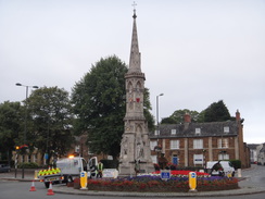
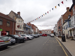
Banbury is a pleasant place, but my thoughts were more on my bladder than architecture as I strode through the town, which was just waking up from its slumbers. A unicyclist came past me - the first I have seen for years. He seemed rather expert at it, especially as I'd fall off after two feet if I tried. Soon the first surprise of the day came into view: the tall spire of Banbury Cross, magnificent even against the grey skies. The cross was built in 1859 to celebrate the marriage of Victoria, Princess Royal. The cross in the nursery rhyme �Ride a cock horse to Banbury Cross" refers to one of the earlier crosses in the town, which were destroyed by the Puritans. It is a fairly dramatic structure, and is enhanced by a bronze statue of a woman on a horse nearby.
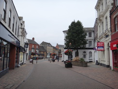
More importantly for me, there was a toilet block on the other side of the road from the cross. It cost ten pence to spend a penny, but it was worth ten pounds to me. Relieved, I headed on through the town. There were lots of nice buildings, mostly made of stone, including the round tower of St Mary's church. The interesting buildings got fewer as roads took me out of the centre, and soon I was following suburban streets through Neithrop, where I hoped to join a footpath that would take me northwestwards across fields.
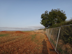
A fence soon blocked my way, and beyond it lay groundworks for what looked like a new housing estate. Fortunately there was a well-walked path beside the fence, which led me into the next field, where the farmer had not bothered to harvest a small section of crop that lay on the far side of the fence. My concerns of the way being blocked soon dissipated as the fence returned into the first field, allowing me to rejoin the path.
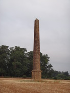
This led down into a valley, before heading up across a field to my second unexpected find of the day: an obelisk standing at the top of the field. The inscription appeared to be in Latin, but a fresh piece of graffiti carved into one side was dated just a couple of days earlier. The web states that this was: �commissioned by Francis North, the Earl of Guildford, to commemorate the visit to Wroxton and the Banbury races, by the Prince of Wales, Frederick of Hanover in 1739."
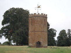
A path led down from the obelisk, bisecting a pond before climbing up to a flat area near the village of Wroxton. Here I got the third surprise of the day: a short, crenelated octagonal stone building, which was apparently a dovecot. Webpages seem to be rather dismissive of this, but I thought it was a fairly interesting structure. These two monuments, along with more that I did not pass, had been constructed in the grounds of Wroxton Abbey, which is now a school.
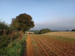
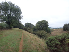
My route did not take me to the village of Wroxton, and instead headed past the dovecot to join a path along the top of a dryish valley (in that it was dry aside from a small stream at the bottom). It was a very attractive area, and in some ways reminded me of some of the smaller Derbyshire valleys. This was starting to be one of the best walks I have done for some time.
Unfortunately I did not have time to stop and admire the view: there are only a handful of buses from Shipston-on-Stour to Banbury, and there was not one for three hours after the one at 13.40. Not wanting to wait around for that long I pressed on, as it would be tight for me to finish my planned 21-mile route before then. As I walked I got a phone call from Sencan - she could not find her door keys, and had to take our son to nursery. I could have sworn I had left them on the inside of the door when I had left, and then locked the door behind me. This is my SOP on early starts, so if there is an emergency she does not have to search for her key and can unlock the door immediately. However she told me the keys were not in the door, and that they were nowhere in sight.
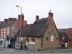
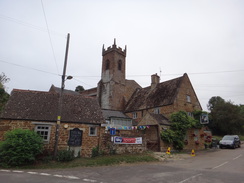
She said she could manage for the morning, but it was clear I should get back as quickly as possible. Not wanting to miss the bus, I studied the map and decided on a more direct route that would use roads instead of footpaths, and sped up. A road took me uphill into Shutford, whose pub nestles comfortably right under the church. Another road lead northwestwards out of the village, eventually curving towards Epwell. Instead of following the road into the village, I decided on taking a short-cut footpath that ran immediately to its north - although I am far from convinced it saved any time.
Sencan phoned as I walked across a field, and told me she had found her house keys on a pillow in our room - presumably placed there by our son. It was a relief that she could now lock the door, but I had already chosen a shorter route for the day's walk, and I was in no mood to try to extend it. Instead I crossed a road and followed another path past paddocks, and then another that led to a complex road junction to the west of Epwell.
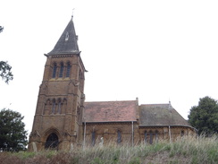
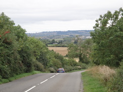
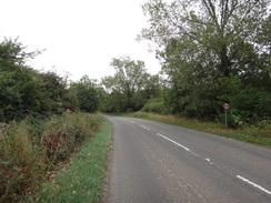
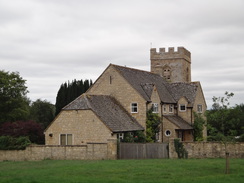
Long, winding roads took me to Winderton, whose church sits majestically above a bend, and to the north of the villages of Lower and Upper Brailes. Some of the views to the west were fairly expansive, with the Cotswold hills in the distance, but I was too busy walking to enjoy them. The road skirted the village of Upper Brailes, but I did not see much of it as the B4035 road led westwards. I was concerned about traffic, and had seen paths on the map that would take me off the road if it was too busy - at the expense of a longer route. Fortunately however, the road was relatively quiet and I could press on westwards.
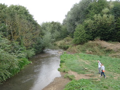
It was a boring walk, made worse by the surrounding hills and terrain I should have been walking over. I soon realised I was not only going to catch the bus I wanted, but that I was in plenty of time to catch the one before that. For that reason I diverted off the main road to head to the village of Barcheston, where I hoped to view the church. Unfortunately this was behind a house so I could not get a good photo, and I could not be bothered to make much more of a diversion. Another road led back to the main road, and soon afterwards a bridge over the River Stour made me think of its namesakes in Suffolk and Dorset that I had walked.
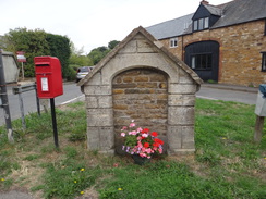
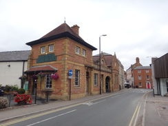
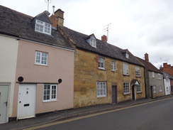
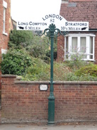
Shipston-on-Stour stood on the river's western bank, and I took a slightly looping walk to have a quick look around what was a rather pleasant town. There were all the usual shops and some nice architecture, but I was keen to get to the bus stop, which was on the main road to Stratford. An attractive milepost stood opposite the bus stop, and I idly wondered if the mileages displayed were still correct with modern road alterations. The bus soon arrived, and took me back to Banbury and my car.
It had been an odd day's walk: it was unusual to finish a walk before midday, and it was a (for me) fairly short walk, and much shorter than I had planned. However there had been a few treats to see earlier on, and this walk sets me up nicely to do another that will connect up with the Cotswold Way in Chipping Campden, whilst also taking in Warwickshire's highest point.
 |
 |
|
Directions
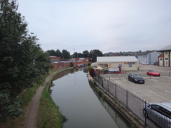
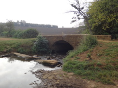
This walk starts off at Banbury railway station at SP46164042. Leave the station and follow the station approach as it curves left to cross the River Cherwell, and then right, passing a car park and the Oxford Canal on the left before ending at a T-junction with Bridge Street. Turn left along Bridge Street, immediately crossing the canal on a bridge, and continue on to a crossroads with the A4260 at SP45934057.
Carefully cross the road using the pedestrian crossing and continue straight on up Bridge Street, passing the entrance to the bus station and the Castle Quay shopping centre on the right. A roundabout is soon reached; head straight on and take the left-hand of two pedestrianised roads (High Street) leading off the roundabout, which passes an impressive building (the town hall) on the right. Continue along the High Street as it curves to the left and ends at a T-junction. Turn right to continue west along the High Street, which soon ends at a roundabout at SP45354040 in front of Banbury Cross.
Turn right to head north up the A361. This passes St Mary's church on the right and after 350 metres ends at a road junction with Warwick Road near The Three Pigeons Inn. Turn left along this road, which curves right and then left; after 750 metres a roundabout is reached. Carefully cross the road coming in from the left and continue along Warwick Road for a short distance past a second roundabout on the right, and at the third, smaller, roundabout immediately afterwards at SP44544110.
At the third roundabout, turn left down Cromwell Road. The road heads straight on before curving gently to the right; take the second road off to the left, 'The Link', and follow this for a short distance until it ends at a T-junction. Turn left along The Fairway, and take the second road off to the right, Prescott Avenue, which after 500 metres ends at a T-junction with Bretch Hill. Turn left along the road for a few metres, and then right up Edinburgh Way. This gently curves to the right; ignore Highclere Gardens on the left, and when an area of grass between two rows of houses on the left is reached shortly afterwards, turn left along a path with the grass on the left and houses on the right. This leads to a gate in a hedge at SP43414074.
Note: the next section is subject to change, as the field is being developed for housing (2018)
Enter the field, and turn left to follow a hedge on the left. When the field's corner is reached after a few metres, turn right to follow a hedge westwards. Cross a track and continue following the hedge; after a short distance, when some trees appear on the right and before you have gone too far downhill, turn right across across the field to join the trees, keeping them on the left. At the field's corner, continue on through a gap into a second field. Follow the trees on the left downhill; they soon turn sharply right; follow them, and when they end turn half-left to head down the field, aiming for the bottom corner at SP42444114.
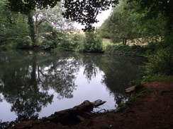
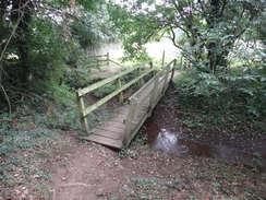
In the corner, turn left to cross a farm bridge over a stream to enter another field. Turn a few degrees to the right to head up the field, aiming directly for an obelisk at the top. Pass the obelisk on the left, and aim for the right-hand edge of the trees behind. Go through a gap in a fence to enter a grassy area, and head downhill. At the bottom enter a band of trees. Cross a causeway between two lakes (with the one on the right behind a fence), and then go through a gate to leave the trees and enter a field. Head uphill, angling slightly away from the hedge on the right, and pass a pond protected by trees on the left. The path curves to the left slightly as it climbs, and in the corner of the field reaches a clapper gate beside a field gate. Go through the gate and angle left across a field to reach Wroxton Dovecot at SP41504151.
Pass the dovecot and parallel a fence on the left. At the far, western, edge of the field go through a gate behind a tree to enter a small paddock. Follow an avenue of trees, with a barn away to the right, to reach a pedestrian gate at the far end of the paddock. Go through this into another field. Follow a hedge on the left for 250 metres until it reaches a stile through a hedge that emerges onto a road at SP41034139.
Cross the road and turn left for a few metres to reach a gap in a hedge. Go through this, and then angle left through a small band of trees to enter a field. Head straight on; there is a newly built (2018) bank on the right. At the end of the field the bank ends; go through a broad gap in the hedge ahead into a second field. Head straight on diagonally across this field; when the path meets the far hedge, go through a gate in the hedge to enter a rough area of land at SP40604105
Turn left to follow the hedge on the left, with a valley called Padsdon Bottom below to the right. When the trees on the left end, angle slightly to the right, skirting along the hillside to reach a stile through a hedge. Go through this, and on the other side continue on, slightly below the hedge on the left. The path then slowly starts descending, angling away from the hedge on the left, towards some power lines. It heads under the power lines and continues on to reach a fence on the right. The path follows the fence to reach a field gate. Go through this and angle right for five metres to reach a second field gate that leads to a track that runs between hedges. Follow this track until it emerges out onto a road near Wroxton Mill at SP39784054.
Turn left along the road, and follow it as it heads west-southwestwards, climbing uphill before ending after 800 metres at a complex road junction called Five Ways. Cross the road ahead, and then head on along a road for a few metres to another junction, and then turn right along Banbury Road (signposted for Shutford). Follow this road slightly north of west; after 150 metres it curves left to enter the village of Shutford. In the village the road curves to the right at SP38584020, near St Martin's Church and the George and Dragon pub, becoming the High Street.
The road leaves the village and curves slightly to the right to take a west-northwesterly course. After 3km the road curves to the left at a junction shortly after passing Epwell Grounds Farm to the right; follow the road around to the left and start following it south. After 150 metres turn right through a gap in a hedge to join a footpath. In the field angle half-left, passing immediately through a broad gap in a hedge into a second field, and then angle slightly right to head diagonally across the second field, with a hill away to the right. At the corner of this field go through a gap in a hedge, cross a footbridge over a ditch, and then turn half-light into a third field. Follow a hedge on the right. Shortly after a left-hand bend in the hedge, turn right through a pedestrian gate at SP35814084 into another field.
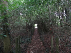
Angle slightly left across this field to head westwards; at the far side cross a footbridge over a ditch and then go through a pedestrian gate into a little paddock. Angle half-left across the paddock for about twenty metres to another pedestrian gate through a fence. Go through this into a slightly larger paddock and head across it to reach a slightly larger gate. Go through this and turn left to follow a hedge on the left. In the corner of this field, go through a pedestrian gate and cross a long footbridge over a ditch to enter some woodland. Follow the path as it curves left through the trees for about five metres to another footbridge over a stream. On the other side, cross a stile to enter a field. Head diagonally across this small field to reach a stile that leads onto a track at SP35374076.
Cross the track and then a second stile to enter a small field. Head straight on across this for twenty metres to reach a bridleway gate in a hedge that leads into a second field. Go through this and angle slightly to the right across this field, climbing a slight slope. At the far side cross a stile over an electric fence and turn right to follow a hedge on the left. This soon curves left to reach a pedestrian gate. On the other side follow a path between fences through trees. When the path ends, go through a pedestrian gate to reach a road at SP35124069.
Cross the road, and on the other side go through another gate to join a path that runs along a broad track between fences. The track climbs a slope; at its end go through a pedestrian gate and turn right along another broad path, with a hedge on the right and a fence on the left. When the track ends, go through a pedestrian gate to enter a field. Head straight on diagonally across this field, aiming for the far corner. Just before the corner, go through another pedestrian gate to reach a road at SP34444067.
Turn right along the road for a few metres to reach a road junction, and then turn left along another road that immediately curves right to take a northwesterly course. After 1km take a road off to the left near Broom Hill, and follow this as it heads west-southwestwards into the hamlet of Winderton. It leaves the village and curves to the right to take a more northerly course, passing the village church on the hillside to the right, before curving left. 2.2km after the junction near Broom Hill, this road ends at a T-junction at SP31854102.
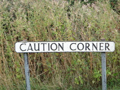
Turn left to head south down this road, and after 275 metres it curves to the right to take a rough southwesterly course; after another 900 metres it curves left to head south. At this bend, turn right to follow a road westwards (ignore another road leading north). After 350 metres this road curves to the left at 'Caution Corner' to head southwestwards into Upper Brailes; after another 500 metres the road ends at a triangular junction with the B3045 road at SP30394015.
Turn right to follow the B3045 northwestwards out of the village; it soon curves to the left to take a more westerly course. There is no pavement after leaving the village, but the road is quiet and the verges are generally wide. After 3.75km a road junction is reached on the left; turn left down this, and after 100 metres turn right down another road at a triangular junction. Follow this road west for 350 metres until it ends at a T-junction with Barcheston Church away to the left. Turn right along the road away from the church for 300 metres until it ends once more at a T-junction with the B3045 road at SP26364024.
Carefully cross the main road to reach the pavement on the other side, and then turn left to follow the road northwestwards. After 400 metres the road crosses the River Stour on a bridge and curves to the left to enter Shipson-on-Stour. When the road curves left, turn right to follow the A3400 north into the town. When this soon curves right, turn left along another road, and then immediately right to enter the High Street at SP25844052.
Follow the High Street, and when it forks, take the left-hand branch along a little lane that soon ends at Sheep Street. Turn left up Sheep Street, and when this ends at a T-junction after 200 metres, turn right up Darlingscote Road. Take the first road off to the right, Telegraph Street, and follow this for 300 metres until it forks. Take the left-hand branch for a few metres to reach the A3400 road; the bus stop where this walk ends is on the other side of the road at SP25894073, opposite an old turnpike milepost.
 |
 |
|
Distances
| From | To | Distance (m) | Ascent (ft) | Descent (ft) |
|---|---|---|---|---|
| Banbury railway station | Wroxton dovecot | 4.0 | 377 | 361 |
| Wroxton dovecot | Winderton | 6.3 | 446 | 420 |
| Winderton | Shipston-on-Stour | 5.8 | 151 | 459 |
This makes a total distance of 16.1 miles, with 974 feet of ascent and 1240 feet of descent.
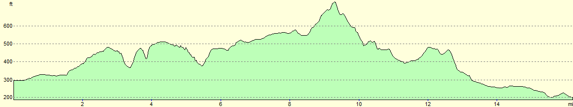
For more information on profiles, ascents and descents, see this page
Transport
Johnson's Excelbus operate the 3A service between Shipston-on-Stour and Banbury. There are only five busses a day, sometimes with a three-hour gap, so you need to take care with the timings.
 |
 |
|
 |
 |
|
 |
 |
|
 |
 |
|
 |
 |
|
 |
 |
|
 |
 |
|
 |
 |
|
 |
 |
|
 |
 |
|
 |
Disclaimer
Please note that I take no responsibility for anything that may happen when following these directions. If you intend to follow this route, then please use the relevant maps and check the route out before you go out. As always when walking, use common sense and you should be fine.
If you find any information on any of these routes that is inaccurate, or you wish to add anything, then please email me.
All images on this site are © of the author. Any reproduction, retransmissions, or republication of all or part of any document found on this site is expressly prohibited, unless the author has explicitly granted its prior written consent to so reproduce, retransmit, or republish the material. All other rights reserved.
Although this site includes links providing convenient direct access to other Internet sites, I do not endorse, approve, certify or make warranties or representations as to the accuracy of the information on these sites.
And finally, enjoy your walking!
Nearby walks
| # | Title | Walk length (miles) |
|---|---|---|
| 621 | Cotswold Way: Stanton to Lower Quinton | 17.0 |
| 631 | A circular walk from Cropredy | 17.8 |
| 996 | Oxford Canal and Jurassic Way: Hayford station to Banbury | 23.5 |
|
|

|