Walk #621: Cotswold Way: Stanton to Lower Quinton
 |
 |
|
General Data
| Date Walked | 29/07/2004 |
| County | Gloucestershire, Worcestershire, Warwickshire |
| Start Location | Stanton |
| End Location | Lower Quinton |
| Start time | 09.13 |
| End time | 17.50 |
| Distance | 17.0 miles |
| Description | This was quite a varied walk; the first half taking me over hills to the end of the Cotswold Way in Chipping Camden, and this was followed y an altogether flatter walk northwards along the Heart of England Way. |
| Pack | Today I carried my 75-litre Craghoppers Rucksack. I did not carry my camping gear, but I did have more other assorted gear with me, which made up for most of the weight of the camping gear. |
| Condition | I feel relatively okay after this walk, with he main problem being that I slightly twisted my left ankle when I fell over towards the end of the walk. |
| Weather | Today started off quite hot and muggy, and it was hot even by the time that I set off. There was a slight cooling wind on the tops, but I was still quite glad when thin clouds rolled over and blocked the sun for most of the time, which meant that the walk was much more comfortable. |
| OS map | Landranger number 150 (Worcester & The Malverns, Evesham & Tewkesbury) and Landranger number 151 (Stratford-upon-Avon, Warwick & Banbury) |
 |
 |
|
 |
 |
|
Map of the walk
Maps courtesy of Google Maps. Route for indicative purposes only, and may have been plotted after the walk. Please let me have comments on what you think of this new format. For a detailed table of timings for this walk, please see the table file.
 |
 |
|
 |
 |
|
Notes
I woke up this morning to the screeching sound made by the water cistern that was obviously above the room that I was staying in. This proved highly annoying, and seemingly occurred whenever anyone went to use the hot water taps anywhere in the house. It was a really intense noise, and it hardly allowed me to wake up in a good mood. To make matters worse the night had been exceptionally muggy, and even with all the windows open I had been far too hot. Breakfast was quite enjoyable, and I chatted to an American gent and his daughter who were visiting Europe for the first time. They were making a whistle stop tour around the UK, and both wore Oxford University sweatshirts at the breakfast table after having visited that city a few days before; it always amuses me the way that tourists buy the university shirts of the cities that they are visiting, whereas people I know who attended those universities never bought or wore them.
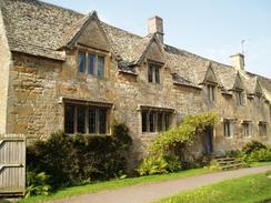
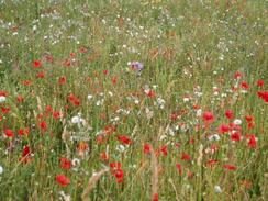
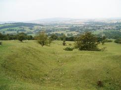
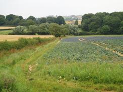
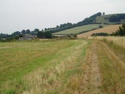
I was not in much of a hurry to set off, and I took my time in pulling all my kit together. Eventually I stopped prevaricating and set off, initially heading uphill through the beautiful and attractive village. I paused regularly in order to admire and photograph some of the buildings that lined the main street, and once out of the village I was faced with a steep ascent up Shenberrow Hill that soon had me sweating and panting for breath on a hot and airless morning. I found that as I ascended I was moving from shadow to shadow, trying to get out of the sun's rays for as long as possible. The only good thing about steep ascents is that they are soon over, and I thankfully found myself walking on flatter ground at the top of the hill and I made better time. A track then led northward, before a gradual descent that passed a field full of wild flowers down towards Buckland. On the other side of the track to the field full of flowers was a cornfield, and the difference in the number of insects in the two fields was quite amazing; the cornfield seemed devoid of them, yet there were lots of bees, butterflies and caterpillars visible in the other field.
The church at Broadway was visible for a long time before I finally reached it, and it acted like a kind of beacon, drawing me forward. Navigation was easy, and I soon found myself on roads, heading past the church and into the village of Broadway itself. I soon found that the place was yet another Cotswold gem, with beautiful stone houses lining each side of the broad road (incidentally, the whole name of the village comes from the wide main road, which was caused by two parallel streams that ran down the centre of the village and prevented houses being built too close to the road). The only negative point was that the village was absolutely full of tourists, and that most shops seemed to cater for tourist needs; when I compared it with Stanton I came up with the conclusion that I much preferred the essentially unspoilt character of the latter.
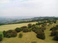
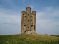
I did not stop in the village and soon left it, starting the steep ascent up the hill towards Broadway Tower. Even though the path was as steep as the one out of Stanton first thing this morning, I found it easier going as by now the sun was hidden occasionally by thin clouds. Eventually I reached the base of the tower, which was open, and I could not resist the temptation to climb up to the top of it. I took my rucksack off and left it resting near the doorway, paid the admission fee and climbed up the spiral staircase that climbs up one of the three towers to the top. One the way there were three intermediate floors, each of which had displays in, and I entered each of these and skimmed the displays before continuing on up towards the top of the tower. When I reached the top I was more than glad that I had made the journey, as the views were absolutely magnificent. Annoyingly it was quite a hazy day, and event though I could make out the Malvern hills far away to the west, they could not be clearly seen; I found myself wishing for the clear, sunny skies of the last few days.
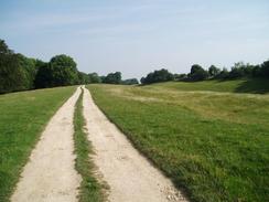
It was with some regret that I left the top of the tower and started the descent down to the base. I chatted to the lady in the souvenir shop on the ground floor for a few minutes, and then walked around the base of the tower to admire the views from a little viewpoint beside the tower. I was well aware that I could not spend all day admiring the view, so I went back to the tower, shouldered my rucksack and headed off down the Way. The path headed northwards towards Fish Hill, and I kept on stopping to look back at the Tower, which stood prominently on the skyline. Annoyingly the best way to approach the tower is from the opposite direction to that I was walking in, and this caused me to keep on looking behind me as I walked. Eventually the path entered a small patch of woodland, and as this obscured the tower from my view I sped up as I approached the main road at Fish Hill. The Way here has recently been diverted to allow a better crossing of the main road, and I followed the obvious signs that led across the road and into the car park for the Fish Hill picnic site. The Way then followed a distinct path across fields, before reaching the start of the Mile Drive, which initially was a gravel track with wide grassy borders, but later on became a wide, grassy track.
The Mile Drive ended at a road, and to avoid tarmac walking the Way has been diverted into the field adjacent to the road. This is followed for a relatively short distance until a crossroads is reached, and it was here that I met a couple of gentlemen who were out on a day hike. One of them had attempted to walk the Cotswold Way the previous year, but had got about halfway before giving in. As I was now within a couple of miles of the end of the walk this made me feel quite proud, and so I left them and headed up towards the top of Dover's Hill. The views from the top of this hill northwestwards were fantastic, and there were quite a few people milling around and having picnics. Dover's Hill is famous not only for it's views over the Vale of Evesham, but also for the Cotswold Olympicks. This was first held in 1612 and was organised by Robert Dover, with competitions as unusual as shin-kicking, Brick and Rolling Pin Throwing, and cheese rolling! Competition stopped in 1852 for several reasons, including the rowdiness of railway Navvies, but it was restarted in 1951 and is still held to this day.
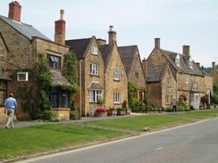
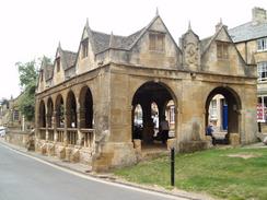
Further along the hill I came across a trig point that I had not been expecting to find. I paused beside this and photographed it, before tackling the last mile of the Cotswold Way down into Chipping Campden. The outskirts of the town were not particularly nice, but the further that I got into the centre the more attractive the buildings became. This culminated in the area around the 17th Century Market Hall, which was surrounded by an orgy of stone buildings. The only problem was that the streets were heaving with both traffic and people, and this somewhat detracted from the scene. Still, reaching the market hall meant that I had finished the Cotswold Way, and hence accomplished the first of my objectives for the trip, which I was fairly elated about. On the other side of the street from the market hall was a tourist information office, and I decided to go in there to see if I could find any accommodation for the night. I figured that I could manage to walk on for another seven or eight miles in the afternoon, and so I enquired for accommodation in the Lower Quinton area. The only thing they had was fifty pounds a night, which is outside my budget, but I then asked if they had an accommodation list for the Heart of England Way. They did, and on it were several far cheaper B&B's on the Way. Quite why tourist information offices do not see fit to tell people about accommodation they have information about is beyond me, and I have been caught out by this before.
Once I had obtained the list I left the office and walked down the street to a pub, and I went in to have a celebratory pint. Most people walk the Cotswold Way in seven or eight days, and I had managed to do it in just five and a half, so I felt as though I deserved a drink (not that it usually takes much of an excuse for me to have one!). Whilst in the pub I phoned up a B&B for the night, and then started chatting to some Australians who were having a meal on the table next to me. The couple were over visiting their daughter who was living in London, and they had all come on a two-week drive around Britain. Their next stop was Edinburgh, and I wondered how much of this wonderful country they would get to see on the long drive northwards. Eventually I decided that it was time to leave, and so I did some stretches before putting my pack on and setting off from the pub. From now on instead of following the Cotswold Way I was following the Heart of England Way, a 100-mile path that heads from Bourton-in-the-Water to near Stafford. The Way leaves Chipping Campden, passing Church Street on the way, and to the right was a curious stone-walled dip. It turns out that this was a ditch that, when filled with water, would be used to wash the wheels of carts going to market. This not only cleaned them, but also expanded the wood and reduced the likelihood of spokes falling out.
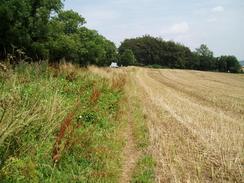
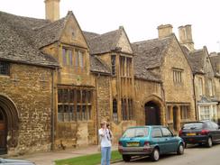
The Way passed a school as it exited the village, and then headed northeastwards across fields towards Mickleton Hills Farm. Just before the farm is reached the line passes almost immediately over the portal of Campden Tunnel, on the Oxford to Worcester railway line. The next couple of miles northwards to Mickleton were fairly uninteresting as it skirts the edge of a small escarpment, and I was quite relieved when I finally reached Mickleton. This was not as picturesque as some of the Cotswold villages that I had passed through in recent days, but it was nice nonetheless. As I followed the footpath out of the village I passed a series of derelict greenhouses, with many panes of glasses missing or broken, and plants growing out through the gaps. It was quite a sad sight, and I was relieved when I got into open air as the path skirted the western side of Meon Hill across fields. Eventually it reached a road in Upper Quinton, and I followed this northward past the village green and onwards for a kilometre until I reached a crossroads in Upper Quinton.
I had no idea where my B&B for the night was, so I nipped into a little shop nearby to ask for directions. Fortunately they knew the place, and so I found myself walking westwards down a road for a few hundred yards to get to Vicarage Farm. The driveway to the B&B seemed to take an age, but when I arrived I was warmly greeted and shown up to my room. The room was not en-suite, but there was a bathroom next door and I treated myself to a long soak in the bath. I was not particularly hungry and I could not be bothered walking back into the village to get myself some food, and so I decided that I could manage without food until the morning. After a while I got fairly bored with reading and went down to the guest sitting room to watch some television, and shortly after I did this the owner, Mrs Spencer, came in and introduced me to a local lady who was visiting her. Her name was Evelyn and she was an exceedingly sprightly 95 years old, and the three of us ended up chatting well into the evening. The talk was highly entertaining, and I went to bed in an extremely contented mood.
 |
 |
|
Directions
The first half of this walk follows the Cotswold Way, which is a well waymarked path that is soon to become a National Trail. I used a guidebook for the walk called 'The Cotswold Way', by Mark Richards (see below). This guidebook is written for north to south walkers and therefore the directions are not quite as useful for the south to north walk, but the hand-drawn strip maps are exceptionally good, and can be read easily from either direction. There was a recreational path guide published for the route, but this is out of print and will only be re-issued, as a National Trail Guide once the path has officially become a National Trail.
|
For the rest of the day I followed the Heart of England Way, directions for which are available in the book Heart of England Way (Recreational Path Guide), published by Aurum Press, ISBN 1854105388. This book has detailed directions and notes of the walk, along with a 1:25,000 strip map of the entire path from Bourton-on-the-Water to Milford. If you wish to buy the guidebooks that I used for the Cotswold and Heart of England Ways that I used, then please click on the link to the right: |  |  |
Distances
| From | To | Distance (m) | Ascent (ft) | Descent (ft) |
|---|---|---|---|---|
| Stanton | Broadway | 4.4 | 758 | 814 |
| Broadway | Chipping Camden | 6.0 | 860 | 689 |
| Chipping Camden | Lower Quinton | 6.6 | 308 | 597 |
This makes a total distance of 17.0 miles, with 1926 feet of ascent and 2100 feet of descent.
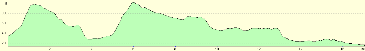
For more information on profiles, ascents and descents, see this page
Accommodation
I spent the night at Vicarage Farm, Lower Quinton, Stratford on Avon, CV37 8RY. It cost m thirty pounds to stay for the night, and I made very welcome by the owner, Mrs Spencer. The B&B can be contacted on (01789) 721108.
Disclaimer
Please note that I take no responsibility for anything that may happen when following these directions. If you intend to follow this route, then please use the relevant maps and check the route out before you go out. As always when walking, use common sense and you should be fine.
If you find any information on any of these routes that is inaccurate, or you wish to add anything, then please email me.
All images on this site are © of the author. Any reproduction, retransmissions, or republication of all or part of any document found on this site is expressly prohibited, unless the author has explicitly granted its prior written consent to so reproduce, retransmit, or republish the material. All other rights reserved.
Although this site includes links providing convenient direct access to other Internet sites, I do not endorse, approve, certify or make warranties or representations as to the accuracy of the information on these sites.
And finally, enjoy your walking!
Nearby walks
| # | Title | Walk length (miles) |
|---|---|---|
| 620 | Cotswold Way: Dowdeswell Reservoir to Stanton | 19.8 |
| 622 | Lower Quinton to Buckley Green | 22.2 |
| 1016 | Banbury to Shipston-on-Stour | 16.1 |
|
|

|