Walk #825: A circular walk along the Itchen Way from Cheriton
 |
 |
|
General Data
| Date Walked | 08/01/2009 |
| County | Hampshire |
| Start Location | Cheriton |
| End Location | Cheriton |
| Start time | 08.02 |
| End time | 14.56 |
| Distance | 18.8 miles |
| Description | This was a pleasant walk following the Itchen Way towards Winchester, then heading back via local roads and the South Downs Way. |
| Pack | Today I carried my 30-litre Karrimor rucksack, filled with waterproofs, a flask and other odds and ends. |
| Condition | I have a bad blister on one of my little toes, a symptom of having worn a new pair of boots for the first time. |
| Weather | The day started foggy, and this only lifted in the early afternoon. It was fairly cold, although fortunately there was little wind. |
| OS map | Landranger number 185 (Winchester & Basingstoke, Andover & Romsey) |
 |
 |
|
 |
 |
|
Map of the walk
Maps courtesy of Google Maps. Route for indicative purposes only, and may have been plotted after the walk. Please let me have comments on what you think of this new format. For a detailed table of timings for this walk, please see the table file.
 |
 |
|
 |
 |
|
Notes
I decided to base today's walk on the Itchen Way, a 31-mile walk in Hampshire. I had already walked the southern stretch of this river walk from Winchester before, and I was keen to walk the northern half. The Itchen Way starts near the village of Cheriton, which I had walked through on a couple of occasions when following the Wayfarer's Walk, then roughly follows the river north, west and finally south towards the sea. I decided to do the northern half of the walk from the source in a one-day circular walk due to the paucity of public transport in the area.
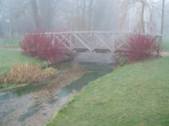
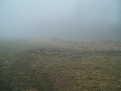
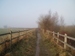
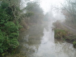
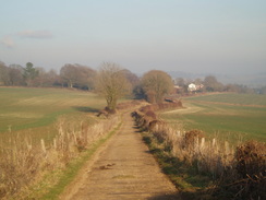
The day dawned foggy, and this had not lifted by the time I reached Cheriton. I parked my car near the school and took some photos of the river, which runs through the centre of the village, swathed in fog. It took me a couple of minutes to pull my kit together, and then I headed off down the road. I stopped almost immediately at the village post office, where I bought some snacks for the walk ahead, then followed the road southwards out of the village. For a period this followed the side of the river in what would have been a pleasant stretch in the sun. Unfortunately, the fog as still as heavy as ever. My old, long-lasting pair of Meindl boots were just about on their last legs, and so I decided to use this walk to started breaking in a new pair.
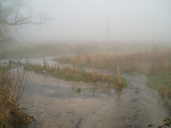
I was unclear where the Itchen Way actually starts - some websites say Hinton Ampner gardens, but the OS map has it starting on a lay-by on the A272 on Harnham Hill. As the gardens are often closed to visitors, and the lay-by is nearest the source of the river, I chose to start there. The road soon ended at the A272; I could have followed this uphill to the lay-by, but instead I crossed the road and headed south for a short distance to reach the field that is marked as being the source of the river. This was a boggy field with little to see, particularly in the fog. Then a road led me uphill to the lay-by. There were no markers denoting this as being the start of the path, so I just headed off sown the A272. Fortunately there were a series of aly-bys down the gill which, when strung together, gave me an off-road route.
The Itchen Way diverts uphill north out of Cheriton, meeting the Wayfarers's Walk before heading west down into the village. Therefore, exactly an hour after I had set off, I walked past the car and through the village. Annoyingly the fog still reigned. A series of paths took me north to Cheriton Mill, and then a
From here, paths took me north towards Tichborne House, initially across a ploughed field. It proved hard to find the path on the ground, so instead I chose to walk along the edge of the field, a longer but surer route. The path passes some gates leading towards the house, then went along a track before cutting across a field to reach the A31. Surprisingly the path does not actually reach the road; it runs along the top of a cutting for a short distance (with the road invisible through trees below), then heads back to cross the river near Vernal Farm. This detour cuts off a stretch of the River Itchen, so you miss the point where it meets the River Alre to the west of Alresford.
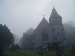
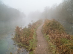
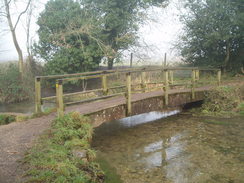
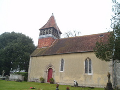
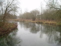
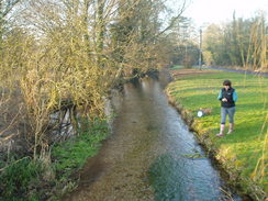
Soon the path crosses the river once again and climbed a hill; on the tops here I almost got my first glimpse of the sun as the fog was slightly thinner. Unfortunately the path led downhill to cross the A31, and I descended back one more into the fog. Ovington was quite a pleasant, sleepy little village; I could not get a good photograph of the church in the fog, and instead walked on past a pub (which had a pretty pond outside it) towards a footbridge over part of the river. What followed was probably one of the best stretches of walking that I have done for some time - the path runs along a narrow strip of land between two streams of the river. The water was perfectly clear, and large brown fish - trout? - could be seen valiantly swimming against the flow. It was a magical spot; it was just a shame that the views were somewhat spoilt by the fog.
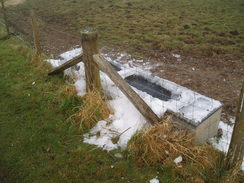
The path followed the road through Itchen Stoke for a short distance, before recrossing the river and then skirting a lane. One farm trough beside the road had evidently been frozen for many days - there was a large pile of broken ice on the ground beside it, a sign of how the recent cold spell has lasted through many days. A path then led uphill, and led me past a golf course before dumping me onto a road.
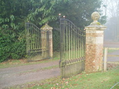
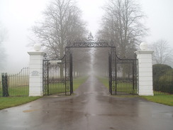
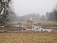
This road led past a lodge and an impressive set of gates that led towards the spectacular Georgian Avington House. Sadly, this was not really visible. A bridge led across the river, and the church in Martyr Worthy seemed like a good place to stop for lunch. I took my rucksack off and perched on the side of the lych gate whilst I poured myself some tea out of the flask. Suddenly a car pulled up; it was a Hampshire footpaths officer come to inspect a reported muddy stretch of path. He had no sooner disappeared that another car pulled up; this held a local couple who were coming to dispose of the church's Christmas tree. I had thought it was a sleep spot; it turned out to be very busy.
This couple told me that just a short distance away was Earl Grey's summer house. The infamous Earl Grey used to attend parliament at night, then catch the train to Winchester and walk along the river to his summer house. It is a fascinating piece of local history that I would otherwise have missed.
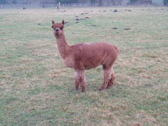
Eventually I pulled myself away from the conversation and continued onwards. The path headed west, above and mostly out of sight of the river. It crosses a road at Chilland, before ending at another road in Martyr Worthy. Here it was unclear where the Itchen Way went; I walked down the lane for a short distance before taking another footpath that headed west along the river before ending at Easton Lane. This took me across the river for the final time in the day. In Easton a footpath took me through some fields past a farm, and I was surprised to find two Llamas munching grass in the field.
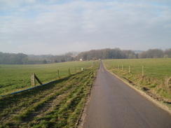
From Easton roads took me eastwards, initially along the floodplain before climbing over a little hill past a lodge. Finally views of Avington House become visible over Avington Lake. After this another long road walk took me southwards towards A31. I set myself the target of reaching the A31 by half past one, and I just made it with a minute to spare. On the other side of the A31 a road took me up to a farm, and from here the South Downs Way led me on arrow-straight southeastwards, climbing and falling as it went. This was a pleasant walk, as by this time the fog had well and truly lifted.
Eventually a field was reached near the A272, where my route left the South Downs Way. I had done the last stretch of walk before last year, as part of a circular walk along the Wayfarers Walk. Despite aching feet it was therefore easy to follow the path northeastwards. There was not much to see on this stretch, and Sencan phoned me up as I joined the road at Hill Houses.
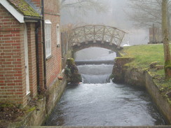
I was fairly tired by the time that I reached Cheriton one more. The sun was shining, and the river through the village looked beautiful; a dramatic difference to the foggy, bland appearance earlier in the day. It had been a good day's walk, and, even better, my feet had not suffered as much as I expected from the new boots.
 |
 |
|
 |
 |
|
Directions
This walk starts off by the school in Cheriton. Turn left, and start walking along the road; it passes the Post Office on the right, then reaches the B3046 road. Turn left and start following the B3046 southeastwards. A little over half a mile alter, it reaches the A272 road. Carefully cross the A272, and then follow Kilmeston Road southwards. The road bends to the right; in the field on the right are the springs that mark the source of the River Itchen. A few yards after the bend the road curves back around to the left; here, continue straight on along a minor road that climbs uphill for a quarter of a mile before ending at a lay-by on the A272 on Harnham Hill. As far as I can tell, this lay-by marks the start of the Itchen Way.
Turn right and follow the lay-by until it ends. Follow the A272 down the hill once more; there are frequent lay-bys that can be used to keep you off the road, When the B3046 is reached once again, turn left and follow it northwards. When it curves to the left after a few hundred yards, turn right along a footpath that heads northwards along a lane. This crosses another green lane, and after a third of a mile meets Upper Lamborough Lane at the top of the hill. Turn left and cross a stile to follow a hedge on the left; this curves to the right and reaches another stile. Cross this, and take another lane that heads down to end at a road ion Cheriton, near where this walk started.
Turn right along the road, then soon turn left near a bridge to head west for a few yards to the B3046 road; note, from here I am unsure of the correct route that the Itrchen Way takes through the village, as there are several different waymarked paths that lead through it. Cross this road, and then continue westwards for another few yards. Just after a house on the right, turn right to take a footpath that carries the Itchen Way northwards. After 0.6 miles, it passes Cheriton Mill and ends at a road. Turn right along this road for a few yards as it crosses the River Itchen and reaches the B3046.
Turn left to head north along the B3046 for a few yards, then turn left to join a footpath that heads northwestwards across a field. It crosses into another field, where it takes a more northerly course to a band of trees. Continue through these, and the path joins a track that skirts immediately to the east of Tichborne House. From here a tree-lined track heads north; when the track curves away to the left, take a footpath that enters a field and crosses it northeastwards for nearly half a mile until it reaches the A31 road. The path turns to the left, staying at the edge of the field as it heads westwards for a few yards, before curving to the left once more, to head back southwestwards along a little sunken path with a hedge on the right and a field on the left.
This passes Vernal Farm before crossing the Itchen once more and reaching a minor road. Cross the roadm and on the other side head uphill along a footpath. It crosses through a hedge before reaching a band of trees called Trodd's Copse; turn right and follow the trees northwards until it descends slightly to reach the A31 road. Carefully cross the A31, and on the other side turn left down a lay-by. About halfway down this lay-by, turn right along another footpath. This heads through some trees before following the edge of a filed as it curves around. Soon some more trees start on the right, and the path heads west for a short distance to end at a road.
Turn right and follow this road as it heads northwards for a quarter of a mile into Ovington. Pass Ovington church and continue on. The road curves sharply to the right with a pub on the left; here continue straight on along a footpath that crosses part of the River Itchen to reach a raised bank in the middle of the river. Follow this footpath as it heads northwestwards for a quarter mile until it reaches another footbridge. Cross this, and follow a path north to reach the B3047 road in Itchen Stoke. Turn left to walk westwards along the road for a few hundred yards, then turn left to join a footpath that heads southwards across a floodplain to reach a couple of footbridges over the River Itchen.
On the southern side of the river follow the path for a few yards, then take a footpath that heads off to the right. This heads westwards across a couple of field before curving uphill to reach Lovington Lane. It continues in the field for a short distance, skirting the lane, until Yavington Farm is reached. Join the road, and follow it westwards past the farm. Just before a right-hand bend, turn left up a footpath. This climbs uphill before curving to the right to head westwards along the top of a hill. This passes a car park for the golf club before ending at a track. Turn right along this track and follow it down to a road. Turn left along this road, then after a few yards turn right along another road that heads northwards, crossing the River Itchen and heading into Itchen Abbas.
Pass the church and immediately take a path that heads off to the left, heading west for three-quarters of a mile to a road at Chilland. Cross this road, and take a footpath that continues on the other side for half a mile before it too reaches a road opposite Martyr Worthy church. Turn left down this road, and just before it ends take a footpath that leads off to the right. This passes a large garden of a house on the left, before dropping down to skirt near to the river bank. After a third of a mile Easton Lane is reached.
Turn left and follow Easton Lane southwards. It crosses the River Itchen; shortly afterwards a footpath leads off to the left. This heads past a large barn eastwards, before reaching another road in Easton near a pub. Turn left, and follow this road northwards. It soon swings to the right to start heading eastwards. Follow the road for a little over a mile; it climbs uphill to pass a Lodge, before skirting the southern edge of Avington Lake before ending at a T-junction with another road near West Hill Dairy. Turn right and follow this road as it curves southwards for 1.8 miles, passing Avington Manor Farm before reaching the A31.
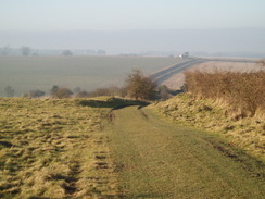
Carefully cross the A31, and follow a road on the other side. This soon curves to the left to head southeastwards for a little under half a mile. At a farm the road ends; here join the South Downs Way and follow it as it heads southeastwards along a green lane. Follow it for nearly two miles; it crosses a road, and then passes near to Ganderdown Farm. From here it climbs uphill before heading into a corner of a field at SU562272. At the corner of the field cross a stile to enter an patch of woodland; here the South Downs Way is left behind. The path follows a track through the trees; at a junction turn left, and after a few yards turn right to cross a stile and join a footpath.
This footpath heads northeastwards with the woods on the right. When the trees end the path turns left for a few yards and then right, to cross a stile and continue on with a hedge on the right. Continue on northeastwards; eventually it joins a concrete track that leads to a road at Hill Houses. Join the road at Hill Houses, and descend downhill to reach the B3046 in Cheriton. Cross the B3046 and follow a road eastwards on the other side for a short distance to a T-junction. The start of the walk was a short distance away on the right.
 |
 |
|
 |
 |
|
Distances
| From | To | Distance (m) | Ascent (ft) | Descent (ft) |
|---|---|---|---|---|
| Cheriton | Start of Itchen Way | 1.5 | 128 | 16 |
| Start of Itchen Way | Easton | 10.3 | 694 | 876 |
| Easton | Cheriton | 7.0 | 615 | 545 |
This makes a total distance of 18.8 miles, with 1437 feet of ascent and 1437 feet of descent.
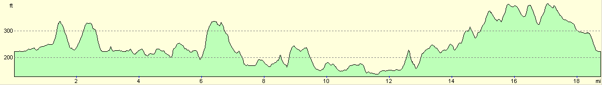
For more information on profiles, ascents and descents, see this page
 |
 |
|
 |
 |
|
Disclaimer
Please note that I take no responsibility for anything that may happen when following these directions. If you intend to follow this route, then please use the relevant maps and check the route out before you go out. As always when walking, use common sense and you should be fine.
If you find any information on any of these routes that is inaccurate, or you wish to add anything, then please email me.
All images on this site are © of the author. Any reproduction, retransmissions, or republication of all or part of any document found on this site is expressly prohibited, unless the author has explicitly granted its prior written consent to so reproduce, retransmit, or republish the material. All other rights reserved.
Although this site includes links providing convenient direct access to other Internet sites, I do not endorse, approve, certify or make warranties or representations as to the accuracy of the information on these sites.
And finally, enjoy your walking!
Nearby walks
| # | Title | Walk length (miles) |
|---|---|---|
| 709 | South Downs Way: Winchester to Wether Down | 20.4 |
| 787 | Romsey to Eastleigh via Winchester | 21.1 |
| 797 | A walk from Wickham to Old Winchester Hill | 23.1 |
|
|

|