Walk #693: Stockport to Bolton via Manchester
 |
 |
|
General Data
| Date Walked | 29/10/2005 |
| County | Greater Manchester |
| Start Location | Stockport |
| End Location | Bolton station |
| Start time | 09.30 |
| End time | 15.23 |
| Distance | 18.2 miles |
| Description | This was a long walk following roads northwestwards through Greater Manchester, heading through the centre of Manchester on the way. |
| Pack | Today I carried my 30-litre Karrimor rucksack filled with my waterproofs, a fleece and various other odds and ends. |
| Condition | I am glad to say that I had no problems with me knees today, and they gave me no trouble at all during the day. The only problem that I had were a couple of hot spots on the underside of my feet, which was understandable as I was using my trainers that I have not walked in for ages. |
| Weather | Thankfully today was a dry day, with clouds overhead and occasional prolonged sunny spells. There was a bit of a stiff breeze, but most of the time the surrounding buildings sheltered me from the worst of it. It was a very mild day for the time of year, and this meant that I did not need to have my fleece on at all during the day. |
| OS map | Landranger number 109 (Manchester, Bolton & Warrington) |
 |
 |
|
Map of the walk
Maps courtesy of Google Maps. Route for indicative purposes only, and may have been plotted after the walk. Please let me have comments on what you think of this new format. For a detailed table of timings for this walk, please see the table file.
Notes
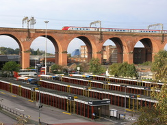
I happened to find myself at my parents' house in South Derbyshire this weekend, and it seemed like a perfect opportunity to do a walk. However because of my bad knees I decided to forego the pleasures of a long walk in the Peak District, and instead chose to do a more uncongenial walk that I had been planning for some time. Earlier in the year I had done two walks that had taken me north from Kidsgrove to the west of Stoke on Trent up to Stockport, and after these walks I had planned to continue on northwestwards through the centre of Manchester to Bury or Bolton. Because of its location I chose Bolton as a target, and hence I found myself driving for a little under two hours to park at the car park by the station in Stockport. This cost me six pounds to park for the day, and although this was expensive I did not mind too much, as it was handy for the railway station.
After using the station facilities I headed back to the car and put my boots on; however, after doing this I decided that as the walk would be along roads I would use my trainers instead of my boots to protect my feet. After changing back into my trainers I locked up my car, and headed off along the side road that leads to the A6 in Stockport. The first couple of hours were very easy navigation wise; it was simply a case of following the A6 as it headed northwestwards out of Stockport and into the southern outskirts of Manchester, passing through Levenshulme and Longsight. The areas were quite mixed culturally, but this led some colour to what was, unfortunately, a fairly pedestrian walk in every sense of the term.
However whilst it was not a classic walk, I still quite enjoyed it as I managed to keep a good speed up, and managed to keep up about three and a half miles an hour for the six miles. I soon found myself passing under the large bridge that carries a motorway over the road, before reaching the imposing Manchester Piccadilly station. By this time I needed to go to the toilet, so I nipped into the station so that I could use their facilities. When I discovered that it cost twenty pence to spend a penny (a sure sign of inflation!) I went onto the main station concourse, found a train that was not due to leave for some time, and used the toilets on that instead. Whilst this was strictly unnecessary, it did put a little challenge into my day, and led to me not to have to pay to go to the toilet at a busy station, something that always annoys me.
After leaving the station I started to head down a street, which after a short time I discovered was called Whitworth Street. Instantly I knew that the street was named after Joseph Whitworth, a Victorian engineer who made his fortune from engineering whom I admire greatly. He has many connections with Manchester, including the fact that he was one of the founders of the technical colleges that later became UMIST. This was a pleasant thought, and as I walked along the street I glanced up at some of the splendid architecture of the surrounding tall buildings. Some of the detail on the stone of these buildings were very nice, and I could not help but study them as I walked, my fascination with architecture once more getting the better of me. Despite this I soon found myself following Princess Street through the city centre, and despite the spectacular Town Hall I was not that impressed - the street trams are fascinating and must be a boon for the population, but for some reason I got the feeling that Manchester was a little soulless - this is undoubtedly a harsh judgement given my impressions were on a walk on one route through the city on one day, but it was the impression that I got.
I nipped into a small branch of Sainsbury's to buy a couple of sandwiches and a pork pie, before heading off down the road across the bridge over the River Irwell. The views from this bridge were quite nice, with a good view towards a modern bridge to the east, and once I was across I entered Salford. Whilst I had visited Manchester before on a couple of occasions I had never been to Salford, and as I walked along the road past several university buildings I was not too impressed, but it was certainly not the worst city that I have ever walked through. A long dual stretch of dual carriageway took me past Salford Crescent station, and I then crossed the road using a footbridge.
A short distance further on the pavement beside the dual carriageway dived off down to the right, and as I did not want to walk along the road without a pavement I followed the pavement. This joined a road that headed parallel to, but below, the dual carriageway, and it proved to be a much quieter and more enjoyable stroll. In Pendlebury the road came to a junction, and here I had to divert off uphill to rejoin the dual carriageway at a roundabout with the A666 road. Putting any concerns at walking along a road with the number of the Devil out of my mind, I joined the A666 and started following it northwestwards. It immediately passed a pretty little church, but after this there was not really much of note until the bridge over the M60, which at least allowed me to look down over trh traffic.
As the road continued I started to get some nice glimpses eastwards towards the dark, satanic hills of the Pennines, the clouds blowing over them as they glinted in patches of sunshine. These short, captured views reminded me of what I was missing and I suddenly found myself pining after the hills. That being said variety is the spice of life, and I was enjoying this walk despite its predominantly urban nature. The road continued on through Clifton and into Kearsley, where it reaches a large roundabout that carried the road over a branch leading from the M61. The two little subways under the roundabout gave me a little variety, but after this I was back on a pavement walk northwestwards into Bolton.
I really did not get to see much of the town, as the station turned out to be on the southern side of the town and I did not get to walk further past it. Annoyingly I had missed a direct train by a few minutes, but I tempered this annoyance wit the fact that there was an indirect train (changing at Manchester Piccadilly) only fifteen minutes later. Additionally, the train journey only cost me £2.55, which was a surprisingly low price, especially when compared to the journey that I made last Sunday. As I waited for the train I could reflect on what had been an unusual but strangely enjoyable walk; I would not want to do one like it every week, but the change from countryside and the high fells was welcome. It also leaves me with easy access to the fells ton the north of Bolton, and Preston and my coast walk is only a long day's walk further north.
Directions
This walk starts off at Stockport railway station; leave the station and turn right, to join Station Road, which curves around to the right before ending at the A6. Turn to the left, and follow the A6 as it crosses high above a river (which is either the end of the Mersey or the start of the Goyt and Tame rivers). Continue along the A6 for about six miles as it passes through Heaton, Levenshulme and Longsight, before passing under a large motorway bridge and almost immediately afterwards reaching Manchester Piccadilly station.
Leave the entrance to the station and cross London Road before taking a road that heads westwards directly opposite, When this ends turn left and then immediately right to start walking westwards along Whitworth Street. After a few hundred yards turn right along Princess Street; this immediately crosses the Rochdale Canal by some locks before heading northwestwards through the centre of Manchester. It passes the magnificent Town Hall on the left, where it becomes John Dalton Street and the bridge Street before crossing the River Irwell.
After crossing the bridge continue straight along the road for a couple of hundreed yards, passing Salford Central station on the left before reaching a road junction. Turn left and start following Chapel Street westwards. Follow this road as it heads westwards through Salford; it passes immediately to the right of Salford Crescent station, where it curves to take a more northwesterly course. Here the road becomes Broad Street, and a pavement runs alongside the western side pf the road until a footbridge is reached just before the B6186 road comes in from the right. Cross the footbridge, and then start following a pavement / cycle path along the eastern side of the road northwestwards.
Just after the A576 comes in from the right, turn right along Brindleheath Road; this head away from the A6 to the right, and after a junction is reached turn left to essentially carry straight on along Duchy Road. Continue along this road for about a kilometre as it passes through Brindle Heath, and when it ends at a T-junction turn right downhill along Bank Lane for a few yards, before turning left up Broomhall road. Take the first road to the left, St John Street, which heads uphill before ending at a roundabout with the A6 and A666.
At the roundabout take the first exit to the right, which immediately passes a church as it heads northwards. It slowly curves to the left to take a more northwesterly heading as it heads through Pendlebury, becoming Bolton Road as it does so. The road crosses first the M60 (where the A666 becomes Manchester Road) and, a couple of miles alter, a branch of the M61 as it passes through Kearsley. Shortly after the M61 there is a junction; turn half-right to follow the A6053 Higher market Street as it heads northwards, becoming Bolton Road once more as it passes Moses Gate railway station, where there is a junction.
Turn left and follow Manchester Road as it heads northwestwards; do not go along the obvious main road to the right but follow the quieter road that runs parallel on the left. This is the B6536 Manchester Road; continue along this for a little under a mile until a large road junction is reached; here turn left to walk up the A579 Trinity Street. Almost immediately this road rises up to cross over the railway line, and the entrance to Bolton railway station is immediately on the right.
Distances
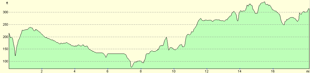
| From | To | Distance (m) | Ascent (ft) | Descent (ft) |
|---|---|---|---|---|
| Stockport station | Manchester Piccadilly station | 6.2 | 184 | 266 |
| Manchester Piccadilly station | Bolton station | 12.0 | 640 | 459 |
This makes a total distance of 18.2 miles, with 824 feet of ascent and 725 feet of descent.
For more information on profiles, ascents and descents, see this page
Transport
There are regular train services (several per hour) between Bolton and Stockport; some of these are direct, but there are also some services where you have to change trains at Manchester Piccadilly. The service that I took, including a change, cost me £2.55 for a single ticket.
Disclaimer
Please note that I take no responsibility for anything that may happen when following these directions. If you intend to follow this route, then please use the relevant maps and check the route out before you go out. As always when walking, use common sense and you should be fine.
If you find any information on any of these routes that is inaccurate, or you wish to add anything, then please email me.
All images on this site are © of the author. Any reproduction, retransmissions, or republication of all or part of any document found on this site is expressly prohibited, unless the author has explicitly granted its prior written consent to so reproduce, retransmit, or republish the material. All other rights reserved.
Although this site includes links providing convenient direct access to other Internet sites, I do not endorse, approve, certify or make warranties or representations as to the accuracy of the information on these sites.
And finally, enjoy your walking!
Nearby walks
| # | Title | Walk length (miles) |
|---|---|---|
| 649 | Macclesfield to Stockport | 18.4 |
|
|

|