Walk #987: Nene Way: Wansford to Warmington and return
 |
 |
|
General Data
| Date Walked | 21/03/2018 |
| County | Northamptonshire, Cambridgeshire |
| Start Location | Wansford church |
| End Location | Wansford church |
| Start time | 09.28 |
| End time | 14.41 |
| Distance | 14.6 miles |
| Description | This was a very pleasant walk following the Nene Way south through Fortheringhay, before returning by the same route. |
| Pack | Today I carried my 30-litre Karrimor rucksack, filled with water, my waterproofs, a book and other odds and ends. |
| Condition | I feel absolutely fine after this walk. |
| Weather | The day started off cold and sunny, but the temperture soon rose as the morning progressed. The wind was chilly when I was exposed to it, meaning I never took my fleece off. Later on, the clouds started gathering, although there were still sunny periods. |
| OS map | Landranger number 142 (Peterborough, Market Deeping & Chatteris) |
 |
 |
|
Map of the walk
Maps courtesy of Google Maps. Route for indicative purposes only, and may have been plotted after the walk. Please let me have comments on what you think of this new format. For a detailed table of timings for this walk, please see the table file.
 |
 |
|
Notes
I was looking for a new project after completing the Ouse Valley Way last week, and the Nene Way seemed like a good choice. Like the Ouse Valley Way, this follows a river from a source in Northamptonshire to the Wash, and although the two rivers are quite close to my home, until this year I had never walked the full length of either trail. I therefore planned the walk, with the first day being a stretch from the trailhead in Badby to Northampton.
Unfortunately I could not set off early this morning, and that left me scrabbling around for a walk I could do without wasting what promised to be a sunny day. Eventually I settled on a stretch of the Nene Way about midway along its length, and one where difficult public transport meant that a circular or there-and-back walk was the best option. Halfway to the start point in Wansford I realised that I had left my wallet at home; however I keep a few notes stashed in the car for just such emergencies, and these would have to do.
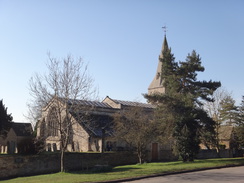
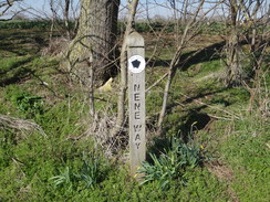
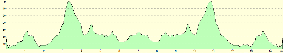
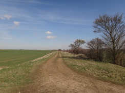
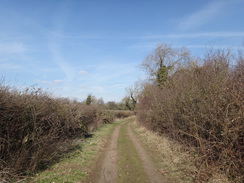
Wansford is a pretty little village, and the yellow stone of the buildings almost shone in the morning sunshine, which was too low to allow a good photo of the church. The trail avoids the old bridge over the river, and instead took a muddy and waterlogged path towards the next village of Yarwell. There was one pleasant surprise - there were frequent waymarkers, with some posts having three Nene Way markers on them. This was a vast improvement from the Ouse Valley Way, where waymarking varied from good to terrible, and I can only hope that it remains the case along the rest of the trail.
Signs pointed around the edge of a paddock, rather than straight through, where Alpacas stood contemplating their breakfast. The diversion did not look very official, and the path's route marker on the map appeared to be well-walked, although now blocked off with fences. I took the diversionary route, which was slightly longer but good going, and on the far side of the paddocks found an official footpath diversion notice dating from only the previous November. I can hardly blame my out-of-date maps for that!
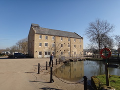
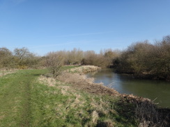
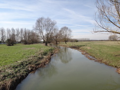
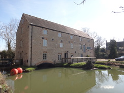
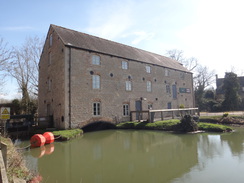
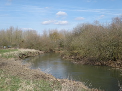
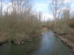
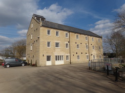
The path led out to Yarwell Mill, where static caravans stretched alongside water. The restored mill shone in the sunshine, although it all looked a little too maintained and fresh, reminding me of a new-build 'mill' I had seen on the Ouse. The river was fairly full and water rushed noisily over a weir, before I reached a little hut housing a riverside cafe. I noted this for later and strode on across the border into Cambridgeshire for a short distance, and the trail soon dived back into the latter county.
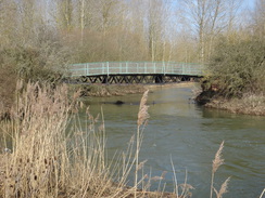
Fortunately the going underfoot was better than it had been near Wansford, and soon I reached a footbridge spanning the river near the remnants of an old railway embankment. My map showed the trail crossing the bridge, but I had checked more recent maps online and had noted the trail stuck to the western bank. As it to confirm this, an overlarge red highways-style sign stated that the crossing 400 metres up was no longer present. I strode on along a good path, and soon reached another sign stating that some stepping stones were no longer passable. A ruined stile led to the riverbank, and all that could be seen in the water was a weir covered with rushing water. Checking online, it appears that the stones have been unusable for years, and there are no photographs of them online.
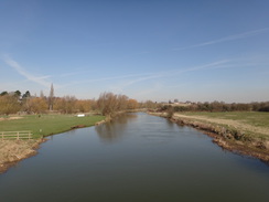
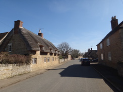
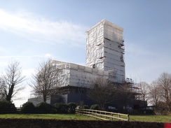
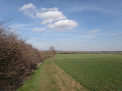
The path headed across the floodplain towards a large farm bridge over another river stream - this one navigable - and entered Nassington. It only flirted with the village and headed out via the playing fields before starting a climb uphill, the only significant climb of the day. A descent via woodland followed, before a track crossed the Willow Brook and headed on to end at a road. This led into the village of Fotheringhay, which was picture-postcard perfect except for one slight problem - the village's exquisite church was wrapped in a white shroud as part of a long project to re-roof it continued.
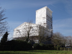
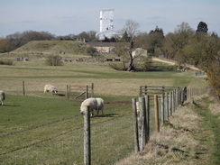
The day's highlight came a short distance on: a small mound with a shallow ditch that was fairly unmistakable castle motte, albeit naked of stones. This is the site of Fotheringhay Castle, which is most famous for being the place where Mary, Queen of Scots was finally beheaded in 1587 after her long incarceration. The castle was founded in about 1100 and fell into ruin in the 1600s. It seemed to have been associated with dodgy monarchs (sorry, Richard III society) as that king was born in the castle in 1452. Only a desultory piece of stonework remains near the river, guarded by railings.
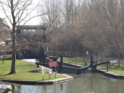
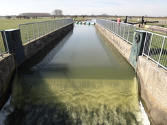
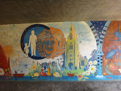
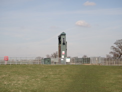
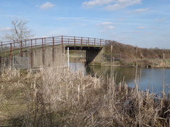
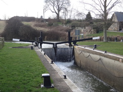
The trail headed up a slight hill before descending down towards a large vertical structure ahead - the guillotine blade of a lock. On the way it crossed the course of an old railway line, now a track. This was part of the old Peterborough to Northampton railway line that closed in 1972 - and if it was still open would have made the transport on this stretch of the trail much easier! After crossing the lock the trail crossed a couple more footbridges and passed yet another restored mill before heading through a gloomy underpass under the A605 that was only slightly cheered by a mural on a wall.
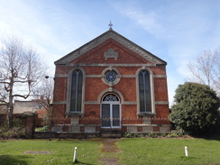
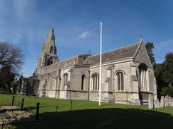
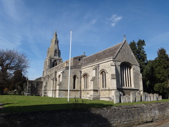
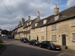
Warmington was a pretty little village, and I made my way past the houses and an unexpected little shop to reach the church. I was only about seven miles into the walk, but this marked the place I'd have to turn around to head back to Wansford. I normally hate these there-and-back walks, but I was actually looking forward to this stroll. I nipped into the shop to look around and discovered it sold records along with the usual food and sundries!
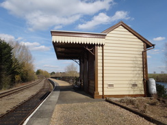
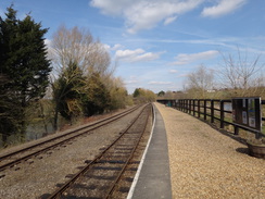
The return was unremarkable; clouds started too gather as I stopped off at Fotheringhay Castle to climb the motte, and later on diverted off the path to walk to Yarwell Junction station, on the Nene Valley Railway. This marked the junction of the Peterborough to Northampton and Market Harborough lines. The lines closed in the early 1970s, and the trackbed from here to Peterborough were purchased by the council and became a base for a railway preservation society. The group have a long-term aim to reopen the line as far as Oundle, using the line I had passed earlier. This would involve rebuilding two or three river bridges, and so would cost many millions.
The riverside cafe at Yarwell had shut ten minutes before I passed, so I strode on through the boggy sections back to my car in Wansford. It had been an enjoyable stroll, although it would have been good to do a little further along the trail before having to turn back.
 |
 |
|
Directions
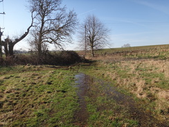
This walk starts off from the crossroads beside Wansford church at TL07359926. Leave the church and walk down Bridge End, passing the church and then a thatched cottage on the right. Just before the bridge is reached ahead, turn right through a clappergate to join a path that runs between a hedge on the right and a fence guarding a paddock on the left. The path soon ends at a pedestrian gate that leads to a footbridge over a stream. Go through a second gate at the far end of the bridge to enter a field. Head across the field, keeping the field boundary roughly to the right, across a field that can be boggy at times.
At the end of this field go through a gate and cross a footbridge over a stream to enter a second field, and follow the field boundary to reach a broad gap in the hedge ahead. Go through this, cross a rough track adjacent to the hedge, and then immediately go through another clappergate that leads into a fourth field. At the end of this field, go through another clapper gate and continue on with the field boundary on the right. When a fence is reached ahead, go through a clappergate and angle slightly right across this field towards yet another clapper gate. This leads to a narrow path that runs between a low wall on the left and a hedge on the right This leads out onto a bend in the road in Yarwell at TL07179777.
Cross the road to join the pavement, and turn left to follow the road around the bend. Immediately after a veterinary surgery on the left, turn left through a bridleway gate to join a track that heads downhill. After about fifty metres, and just before a farm gate is reached ahead, turn right to join a path that follows a hedge on the left and fences guarding paddocks on the right. When the paddocks end, go through a bridleway gate and continue following the hedge on the left. At the far corner of the field go through a gap in a fence and descend a small bank to join a road. Turn left down the road, and after ten yards go past a field gate and head on along the surfaced road; it soon reaches Yarwell Mill at TL07449726.
Turn right in front of the mill building, and once past the sluices turn right along a path. This soon crosses more bridges to reach a bridge over Yarwell Lock. On the other side descend slightly to the left to reach a pedestrian gate that leads into some woodland. Cross an old arch-brick bridge over a ditch and follow the path as it curves right through the trees. After a short distance go through a clappergate and head on between the trees on the left and a fence on the right. Ignore a footbridge that leads off to the left over the river.
About 400 metres after the footbridge a couple of clappergates sandwich a footbridge over a stream. These lead out into a field; turn slightly right to head diagonally across this field, aiming for a gateway at the far side. Cross a farm bridge over a ditch and then go through a clappergate beside the gateway to follow a hedge on the left. This leads to a ramp that climbs up to Wilgay Accommodation bridge over the Nene. On the other side, follow a field boundary on the right. When the boundary curves away to the right, head straight on along a track that leads to a clappergate beside a field gate to reach a road in Nassington at TL06789604.
Carefully cross the road to reach the pavement on the other side, and then turn left to follow the road south. After about fifty metres, turn right past a field gate (often open) along a track that leads up towards a cricket club. Pass into the grounds and immediately turn left, keeping a hedge on the left. Squeeze past a building on the right, and head on with the hedge on the left. Follow it as it turns right, and in the next corner go through a pedestrian gate and then a gap In the hedge to enter a field. Head straight on across the field, aiming for the corner of a hedge ahead. Keep the hedge on the right as you head uphill; it soon crosses a track, and two-thirds of a mile after leaving the cricket club's grounds the path meets a ditch ahead at TL06009508.
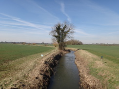
Turn left to keep the ditch on the right for about fifty metres, and then turn right across the end of the ditch to start following a ditch and narrow band of woodland on the left. This descends; at the bottom of the field, after nearly half a mile, go through a broad gap in the hedge to join a green lane. This stops descending and levels off, to cross a bridge over Willow Brook; after another third of a mile, squeeze past a farm gate to reach a bend in a public road at TL05199367.
Turn left to follow a road as it immediately passes a couple of houses on the left; after a third of a mile it ends at a T-junction to the west of Fotheringhay. Turn left to follow the road as it heads east through the village. Pass the Falcon pub and the church, and then as the road curves sharply to the right, head straight on along a track that passes a barn on the right. The track curves gently to the left and then right before turning sharply to the left to pass Fotheringhay Castle motte on the right at TL06259298.
Continue on along the track past a modern barn on the right and across a bridge over a stream, with a pond on the right. A complex of gates is reached a short distance further on; go through a pedestrian gate and after five yards turn right to join a footpath that heads uphill with a fence on the right and a ditch on the left. The path crests a small hill and descends down the other side. The fence on the right ends, and the path passes between fields. Keep on the track as it passes the end of a hedge on the left and curves slightly. The track ends at a clappergate beside a field gate; g through this to enter another field and head straight on towards the obvious guillotine gate of Warmington Lock at TL07259208.
Go through a couple of pedestrian gates and cross the bridge over the lock, and then another bridge over a weir. Go through a third gate to leave the lock complex and continue straight on across a field towards a footbridge that is guarded on either side by gates. On the other side, angle slightly left towards a smaller footbridge over a little depression, and once across angle hard left to head towards the corner of the field and a mill. In the field's corner, go through a clappergate and continue on beside a fence and the river on the right pas the mill, and then turn right to head in front of the mill, crossing a series of bridges over small channels. On the other side, turn left along a surfaced track; cross another bridge and pass a fence squeeze to reach an underpass under the A605 at TL07469159.
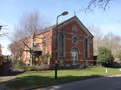
On the other side of the underpass, go through a bridleway gate and continue on as the path becomes a lane called Eaglethorpe; follow this past houses for a short distance until it forks; take the right-hand fork until the road ends at a T-junction with Peterborough Road. Carefully cross this and turn right for a few metres until Chapel Street leads off to the left. Pass an old chapel on the left, and then shortly after the road curves to the left, turn right down Hautboy Lane. This also curves to the left, and a few metres after the bend turn right down Church Lane. Follow this for a short distance until it ends at a T-junction with Church Street at TL07749097.
From here the walk returns by the same route (with a diversion off to visit the ca\stle and Yarwell Junction station). Here are the directions in detail.
Head up Church Lane, which runs past the churchyard's eastern end. When the lane ends at a T-junction, turn left along Hautboy Lane, which curves to the right and passes Glebe Stores before itself ending at a T-junction. Turn left along Chapel Street, which curves right to pass an old chapel on the left. A road comes in from the left, with the Red Lion pub ahead and to the left, and the road curves to the right to merge with Peterborough Road. Carefully cross Peterborough Road, and then turn left down Eaglethorpe. When the road ends go through a bridleway gate and follow a surfaced path that soon passes through an underpass below the A605 at TL07469159.
On the other side, continue on past a squeeze fence and then cross a stream on a bridge to reach the mill. Turn right in front of the mill and cross two bridges over streams, and then turn left to pass the side of the mill for three metres, and then turn right to cross a third bridge. On the other side turn left, keeping a fence and the river on the left, to reach a clappergate. Go through this to enter a field. Turn slightly to the right to head towards a footbridge over a depression, and on the other side turn half-left towards another footbridge over a stream guarded by gates on either side (ignore the larger farm bridge to the right). On the other side, head straight on northwards, aiming for Warmington Lock at TL07259208.
At the lock go through a pedestrian gate, cross a bridge over a weir, and then cross a bridge by the lock and go through two more gates to enter a field. Turn half-left across the field, aiming roughly to the left of Fotheringhay church tower in the distance. Go through a clappergate beside a field gate to join a track that runs between fields.
The track soon passes the end of a hedge on the right to enter another field. Continue straight on with the field boundary on the left; at the end of the field go through a broad gap in the hedge ahead and continue straight on between fields. The path climbs slightly, cresting a hill before descending alongside a fence on the left. At the bottom of the hill the path ends at a track; turn left along the track for a few metres to reach a gate beside a double field gate. Go through this, and continue on along the track, passing a pond on the left and crossing a bridge over a stream. Shortly after passing a barn and just before Fotheringhay Castle motte is reached on the left. Continue along the track as it curves right and left to bypass a farm, soon afterwards ending at a road in Fotheringhay at TL06119309.
Continue straight on along the road through the village, passing the church and the Falcon pub. After 0.4 miles it reaches a road junction on the right beside a long stone wall. Turn right to follow this road for a third of a mile until it reaches a complex junction of roads and paths in front of Walcott Lodge Farm at TL05199367. Turn right down a track and after ten metres squeeze past a double field gate, and then continue along the track. Cross a bridge over Willow Brook and follow the track as it curves to the right and starts climbing uphill. When the grassy track curves sharply to the left, turn right through a broad gap in a hedge into a field and head on uphill, with a field on the left and a ditch and band of trees on the right.
When another field is reached at TL06069507, turn hard left to follow a ditch on the left past a field on the right for about fifty metres, and then turn right to start following a hedge on the left. The path crests the hill and starts descending alongside the hedge on the left. These cross a track, and when the hedge curves left, veer slightly to the right across the field, aiming for a corner of a hedge ahead. At the corner of the hedge, go through a gap and then through a pedestrian gate, and turn half-right to start following a hedge on the right past some cricket pitches. Follow the hedge as it curves to the left, and then squeeze between a building and the hedge to reach a car parking area. Walk on a few metres, and then turn right down a track and follow it until it ends at a T-junction with Fortheringhay Road in Nassington at TL06799605.
Turn left to head north up the road for about fifty metres, and then right through a clapper gate beside a field gate to join a track. As the track veers to the right, head straight on along a vague green track, beside a field boundary to the left. The track curves to the left, following a hedge on the left, to reach a field gate that leads to a ramp that climbs up to Wilgay Accommodation Bridge over the Nene. Descend a ramp on the other side, and follow a hedge on the right. In the corner of the field go through a clappergate beside a gateway and cross a bridge over a ditch, and then angle slightly left across a field towards another river stream ahead. At the riverbank turn left through two clappergates that guard a bridge over a stream. Follow the river on the right for 400 metres until a footbridge over the Nene is reached at TL07569689.
The following paragraph described a diversion to the Yarwell Junction station on the Nene Valley Railway; ignore it if you wish to continue along the Nene Way.
Turn right to leave the Nene Way and cross the bridge. On the other side head straight on; after about twenty metres the path curves to the left to reach a gateway. Go through this and turn left to follow a path along the top of an old railway embankment. Go through a pedestrian gate beside a field gate to reach Yarwell station at TL07899706. To return to the Nene Way from the station, go through a pedestrian gate beside a field gate and head along a path that runs atop of an old railway embankment. Turn right through a gateway and follow a hedge on the right past a field on the left. When the hedge ends, turn right towards a footbridge over the river. Cross this to rejoin the Nene Way at TL07569689.
Follow the path along a broad grassy area between a fence on the left and an area of woodland on the right. Go through a clappergate to enter the woodland; soon afterwards the path crosses a small arched brick bridge over a stream and goes through a pedestrian gate to reach Yarwell Lock. Pass the lock's guillotine gate and cross a footbridge over a stream to join a track that crosses a bridge over a bigger stream. Continue along the track towards the mill at TL07449726.
At the mill turn left to pass in front of it, and then left again to follow the surfaced road, which curves to the right to pass a barn on the left and a house on the right. The road curves left to pass a little car park on the right, after which it joins a road. Turn right up the road for five metres, and then turn right up a bank and through a gap in a fence to join a path that runs alongside a hedge on the right. Go through a bridleway gate and continue on between a fence and hedge. The path curves left and then right and descends to reach a track. Turn left up the track and go through a bridileway gate to reach a road in Yarwell at TL07189762.
Turn right along the road. As it curves to the left, turn right, initially along a surfaced driveway, and when this curves right after a few metres, continue straight on down a path with a low wall on the left and a barn on the right. Go through a clappergate and angle slightly to the right across a field. Go through a clappergate near a field gate into a second field and parallel the field boundary off to the left. At the end of the field, go through a clappergate and continue on across a third field. When this field ends, go through or past another clappergate, cross a track, and head on across a fourth field, still following the hedge on the left.
Cross a footbridge over a ditch and go through a gate into a fifth field. Walk on across a boggy area towards a road bridge ahead, with the field boundary on the left. The path passes a clump of small trees on the left; go through a pedestrian gate and cross a footbridge over a stream; on the other side go through another gate and head on between a hedge and fence. The path soon climbs a bank to reach a clappergate that leads out onto a road in Wansford, with the road bridge off to the right. Turn left uphill to reach a crossroads with Wansford church on the left at TL07359926, where this walk ends.
Distances
| From | To | Distance (m) | Ascent (ft) | Descent (ft) |
|---|---|---|---|---|
| Wansford church | Warmington church | 7.0 | 249 | 236 |
| Warmington church | Wansford church | 7.6 | 233 | 246 |
This makes a total distance of 14.6 miles, with 482 feet of ascent and 482 feet of descent.
For more information on profiles, ascents and descents, see this page
 |
 |
|
 |
 |
|
 |
 |
|
 |
 |
|
 |
 |
|
 |
 |
|
 |
 |
|
 |
 |
|
 |
 |
|
 |
 |
|
 |
 |
|
 |
 |
|
 |
 |
|
 |
 |
|
 |
 |
|
 |
 |
|
 |
 |
|
 |
 |
|
Disclaimer
Please note that I take no responsibility for anything that may happen when following these directions. If you intend to follow this route, then please use the relevant maps and check the route out before you go out. As always when walking, use common sense and you should be fine.
If you find any information on any of these routes that is inaccurate, or you wish to add anything, then please email me.
All images on this site are © of the author. Any reproduction, retransmissions, or republication of all or part of any document found on this site is expressly prohibited, unless the author has explicitly granted its prior written consent to so reproduce, retransmit, or republish the material. All other rights reserved.
Although this site includes links providing convenient direct access to other Internet sites, I do not endorse, approve, certify or make warranties or representations as to the accuracy of the information on these sites.
And finally, enjoy your walking!
Nearby walks
| # | Title | Walk length (miles) |
|---|---|---|
| 56 | Peterborough to Stamford | 16.5 |
| 58 | Stamford to Oakham | 16.8 |
| 643 | A circular walk from Thrapston to Oundle | 19.4 |
|
|

|