Walk #691: Glyndwr's Way: Abbeycwmhir to Llanidloes
 |
 |
|
General Data
| Date Walked | 02/10/2005 |
| County | Powys |
| Start Location | Abbeycwmhir |
| End Location | Llanidloes |
| Start time | 08.55 |
| End time | 16.14 |
| Distance | 16.7 miles |
| Description | This walk followed Glyndwr's Way as it heads northwestwards across Powys. |
| Pack | Today I carried my 75-litre Craghoppers WildPlaces rucksack, with full camping gear including food, which weighed about 45 pounds. |
| Condition | After about nine miles in today's walk the event that I had been fearing eventually occurred;; my right knee went pop, and I found myself in pain on every step that I took. This was particularly the case on descents, and those last few miles were far from an enjoyable stroll. The consequent limping also put more strain on other parts of my body, which means that by the time that I reached Llanidloes I could scarcely walk another step. |
| Weather | Unlike the previous two days, today was dry, with no sign of any rain. At times there was a stiff and chilly breeze, but the ambient temperature was not too bad. All in all it was a fair enough day for a walk. |
| OS map | Landranger number 136 (Newtown, Llanidloes & surrounding area) |
 |
 |
|
 |
 |
|
Map of the walk
Maps courtesy of Google Maps. Route for indicative purposes only, and may have been plotted after the walk. Please let me have comments on what you think of this new format. For a detailed table of timings for this walk, please see the table file.
Notes
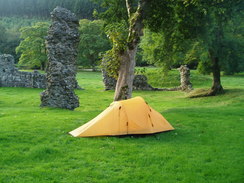
I was groggy when I first awoke this morning, and it took me a few seconds to realise where I was. Unlike the previous morning there was no rain drumming against the flysheet of my tent, and when I stuck my head outside the tent I was relieved to see large sunny patches in the sky. This setoff the ruins of the abbey very well, and once I had fully emerged from the cocoon of my sleeping bag I spent twenty minutes walking around the ruins, taking photos and just touching the stones. The previous evening I had booked myself a B&B in the next town, Llanidloes, and as it was only about sixteen miles away I was in no particular hurry to set off.
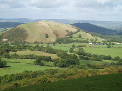
I therefore prevaricated for a while, until eventually I could justifiably delay no longer, and I packed up my tent (which after two nights rain was well and truly soaked), and headed off. Abbey-cwm-hir looked pleasant in the Sunday morning sunshine, and there was no-one about as I headed past the Happy Union Inn and the small but pleasantly formed church. The Way head northwestwards out of the village, climbing through some woodland between two hills; the woods had been cut down recently, and a large expanse of bleak hillside has been left behind.
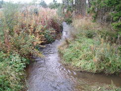
A descent followed, leading down to a footbridge over a stream, where my nostrils were assailed by the vile smells of a decaying sheep beside the path. I hurried away from this, and after crossing a road headed across a field towards the farm at Cwmysgawen. Here, for the first time on the trip, I could not find the path, and took a rather roundabout route to reach the path on the other side of the farm. Away to the right I could see cyclists streaming past along the road, and that reminded me that two colleagues of mine were taking part in a ninety-mile ride in the area today.
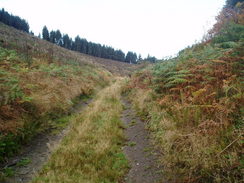
After crossing a boggy area of ground a track took me towards the farm at Lowr Esgair, and a combination of tracks and paths took me on to the summit of Upper Esgair Hill. This hill was traversed for a while towards Lan-fraith, before a rough and stony track led me downhill towards the tiny hamlet of Bwlch-y-sarnau. As I headed towards the road more cyclists came streaming past, and when I was about ten feet of the road two of these screeched to a halt, and I was amazed to find that they were Tim and Graeme, my two colleagues. None of us could actually believe that we had met up on this tiny stretch of road (which my route only followed for a few yards before turning off), and we jovially chatted for a while before they headed on. They were about twenty-four miles into their ride and had a long, long way to go, although at the time the 12 or so miles that I still had to walk seemed equally daunting.
This freak, chance meeting put me into a very good mood, and literally bounced along the track that led northwestwards through woodland from the village. It was a pleasant walk and the weather overhead was overcast, but the rain of the last couple of days was thankfully staying away. A long road stretch followed and there were some good views over to the west, before the Way took a track that headed uphill, skirting the edge of some woodland before passing Prysduon. The Way left the trees behind before passing the farm at Trinnant, and a short distance on I sat down for a rest at the halfway point of the day's walk, near the farm at Grach. I was feeling very, very happy, and in my mind I was mentally planning the next few days' walks to Machynlleth and beyond. I opened a pack of nuts and raisins and started scoffing them down as I sat, until eventually the chilly breeze caused me to want to start moving once again.
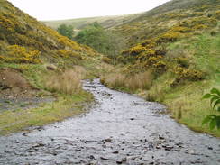
The Way led on to a footbridge and ford over a pretty stream, before skirting a hillside along an indistinct path above the farm at Rhiw-felen. A track led me down to a road that took me past the farm at Cloesffynnon, and another track then led on northwards. The going underfoot was easy and I was feeling fine as I bounced along, admiring the wind turbines on the hillside to my right. Unfortunately I then felt a sharp pop in my right knee, and over the next couple of steps sharp, piercing pains appeared on the right hand side of the kneecap. I hobbled on and the pain subsided slightly, but as the track started to head downhill steeply into a valley the pain increased substantially. It was a repeat of the pain that I had had two months previously in the Peak District, except this time instead of a daypack I was carrying full camping gear.
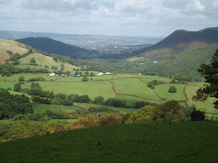
The descent was extremely painful, and I realised as I walked that this meant that today would be the last day of the walk. This hit me hard, and the sudden let-down after the joy I had been feeling just half an hour before was depressing. After crossing a footbridge over a stream I was faced with a very steep path that headed up a field, and although this was steep I found that my knee hurt less. Once the path became a track, which was still ascending uphill, it got even better, and I was left wondering if the pain had gone. Unfortunately as the gradient slackened and the track became a level road the pain came back, and I could scarcely care about the superb views over the Severn Valley that unfolded below me. I did manage to take a panorama from near Pen-y-bant, and I studied the wind farm on the hillside to the east, but the pain left me wondering if I could complete the day's walk.
The path rose and fell as it headed west past Moelfre, and I soon found myself at the top of a shallow but steep-sided valley that I would have to cross. My knee hurt like hell on the descent, but as the rose up the other side the pain died away into a dull ache. It was obvious that the problem was on the descents and the level, and that when climbing it was scarcely there. This was hardly a welcoming thought, and as I walked up the track towards the road at Prospect Farm I found a couple of tears come down my face from the exertion.
Once on the road I limped downhill, only to meet a couple coming up in the other direction. I stopped to chat to them, and it turned out that the gentleman had walked Glyndwr's Way on two previous occasions. The chat cheered me up somewhat, and once I reached the chapel at Newchapel I followed another road that led painfully downhill to the west. The Way soon left the road and started heading downhill along a path into another steep-sided valley. The descent was once again painful, and on the ascent I started to realise that the limping was causing me to put strains on other parts of my body, and that I was getting tired very quickly.
Once out of this valley the Way joined a road, and this was great relief, as I could follow it all the way downhill into the centre of Llanidloes. I limped on, my knee hurting intensely whenever the descent became steep. A footbridge took me over the A470(T) on the eastern side of the town, passing some magnificent old railway buildings before heading down suburban streets into the centre of the pretty town. There were many buildings of interest, but in my decrepit condition I did not pay much attention to them as I reached the half-timbered market hall in the centre of the town. It looked like a lovely place to explore, but all I was interested in was finding my accommodation for the night, and I was relieved when I discovered it was only about fifty yards away down the road.
I booked myself in, and found myself in a pleasant twin room in an outbuilding from the main pub. I immediately stripped off and ran a bath to have a long soak. This seemed to have a positive effect, and as I lay motionless the pain and aching from my knee slowly receeded. I stood up to get out of the bath in a more positive mood, only to have my right knee nearly buckle on me, the pain shooting up my leg as if my knee had been hit by a sledgehammer. Depressed, I dried myself off with a towel and went to lie in bed. As I watched the television it was obvious that I would be in no condition to continue the next day, and that for the first time in over six years and 11,000 miles I had failed to complete a long-distance walk. Once the pub opened at six I dragged myself across the courtyard and into the pub where I had a couple of pints and a meal, but even the jovial chat of the landlord could not pull myself out of the depression that hung over me. This increased when my parents phoned me up, to tell me that an auntie had had a stroke. Instantly my troubles vanished with concern for another, and I retired to bed in a troubled mood.
Directions
|
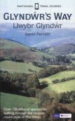
The walk is also covered in detail in the Glyndwr's Way National Trail Guide, by David Perrott, ISBN 1 85410 968 5, published by Aurum Press Ltd. Please click on the link to the right to access the Amazon page for the guidebok. |
|
Distances
| From | To | Distance (m) | Ascent (ft) | Descent (ft) |
|---|---|---|---|---|
| Abbey-cwm-hir | Bwlch-y-sarnu | 3.8 | 1056 | 620 |
| Bwlch-y-sarnu | Trinnant | 4.0 | 774 | 781 |
| Trinnant | Newchapel | 6.4 | 1588 | 1923 |
| Newchapel | Llanidloes | 2.5 | 308 | 712 |
This makes a total distance of 16.7 miles, with 3726 feet of ascent and 4036 feet of descent.
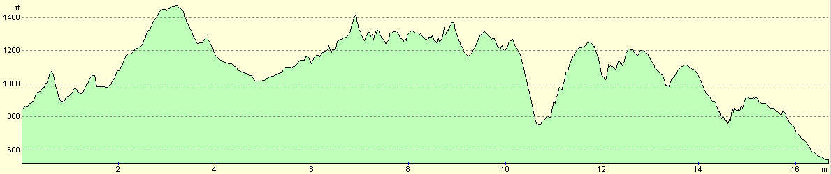
For more information on profiles, ascents and descents, see this page
Accommodation
I spent the night at The Mount Inn, China Street, Llanidloes, Powys, SY18 6AB. This Inn is situated in the middle of the town, and some good accommodation in some adjacent chalets cost me Ł35.00 for the night. The Mount Inn can be contacted on (01686) 412247.
Disclaimer
Please note that I take no responsibility for anything that may happen when following these directions. If you intend to follow this route, then please use the relevant maps and check the route out before you go out. As always when walking, use common sense and you should be fine.
If you find any information on any of these routes that is inaccurate, or you wish to add anything, then please email me.
All images on this site are © of the author. Any reproduction, retransmissions, or republication of all or part of any document found on this site is expressly prohibited, unless the author has explicitly granted its prior written consent to so reproduce, retransmit, or republish the material. All other rights reserved.
Although this site includes links providing convenient direct access to other Internet sites, I do not endorse, approve, certify or make warranties or representations as to the accuracy of the information on these sites.
And finally, enjoy your walking!
This walk was mentioned in the following routes:
| Glyndwr's Way |
Nearby walks
| # | Title | Walk length (miles) |
|---|---|---|
| 690 | Glyndwr's Way: Beacon Hill to Abbeycwmhir | 22.2 |
|
|

|