Walk #689: Glyndwr's Way: Knighton to Beacon Lodge
 |
 |
|
General Data
| Date Walked | 30/09/2005 |
| County | Powys |
| Start Location | Knighton station |
| End Location | Beacon Hill |
| Start time | 14.23 |
| End time | 18.36 |
| Distance | 10.8 miles |
| Description | This was a short walk, following the first eleven miles of Glyndwr's Way westwards from Knighton. |
| Pack | Today I carried my 75-litre Craghoppers WildPlaces rucksack, with full camping gear including food, which weighed about 45 pounds. |
| Condition | I feel okay after this walk; I have no significant problems with my right knee, although the muscles in my left thigh were extremely stiff on the ascents; this was probably due to the fact that I had been sitting down on trains for most of the day. |
| Weather | By the time my train pulled into Shrewsbury the skies were sunny, and this caused me to pack my coats into my rucksack. Unfortunately by the time that I reached Knighton it started to spit with rain, and this got heavier over time. Towards the end of the walk it was raining heavily, and I was walking through mist that was being blown along by a fierce, biting wind. |
| OS map | Landranger number 148 (Presteigne & Hay-on-Wye area) |
 |
 |
|
 |
Map of the walk
Maps courtesy of Google Maps. Route for indicative purposes only, and may have been plotted after the walk. Please let me have comments on what you think of this new format. For a detailed table of timings for this walk, please see the table file.
Notes
The journey from my home in Great Shelford to Knighton and the start of Glyndwr's Way promised to be a long one, and a ten-minute delay to my first train to Cambridge did not bode well. However, the pack on my shoulders felt fine, my knee was not giving me any trouble, and generally I was feeling quite happy at the thought of nine days walking in mid-Wales.
A change at Cambridge and then at Birmingham took me as far as Shrewsbury, where I had a little wait for the train. This gave me an opportunity to have my water bottles filled, and explore the area outside the magnificent station building. Unfortunately once I reached the platform I discovered that the train was due to be late, and so I took my coat off in the warming sunshine and waited.
The train eventually headed off about half an hour late, and as it was only a single car and very crowded I stood in the vestibule, chatting to a businessman going home to Craven Arms after a foreign trip. As the train continued the clouds started to gather, and the businessman was replaced with a pleasant local girl whom I chatted to amiably before, eventually and over half an hour late, the train pulled into Knighton. As we chatted I used the opportunity to performs some stretches, well aware of previous difficulties that I have had starting walks immediately after long train journeys. It took a few minutes for my GPS to acquire its location, but once it had done so I shouldered my rucksack and headed off into the centre of the town.
I had been to Knighton on a previous walk, and I remembered that I had been quite impressed by the quiet town, which is nestled on the English and Welsh border. I took my time walking to the grand clock tower in the centre of the town, which marks the start of Glyndwr's Way, mainly in order that I could slowly wean myself into the walk. However the pack on my back felt fine despite weighing over 4t5 pounds, and by the time I reached the cross I was more than ready to tackle the first ten miles of the way.
When I had been planning the trip I had been fairly ambivalent about my plans for the first day; an obvious choice would be to stay in Knighton overnight, but with five hours daylight available after the train was scheduled to arrive a short day seemed certainly achievable. The late arrival of the train had not changes my mind, and so, as the drizzle started to descend, I headed off uphill, passing a stone marker representing the start of the way before getting some superb high views over the town as it headed southwestwards.
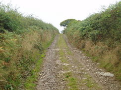
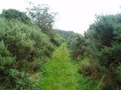
A climb, descent and another climb took me to Garth Farm and some more good views, before the Way continued along the flank of Garth Hill. I was feeling fine and the drizzle soon stopped, making the walk along the muddy but wide path a very pleasant experience, which was rudely interrupted when the path ended at a road. This had to be followed downhill, but the Way soon tuned off to climb uphill along a track, passing Ebrandy House. Nearby an obviously Mixyd Rabbit was on the track, and I looked at it with some sorrow; the poor thing was nearly blind and was running from one side of the track to the other as I approached.
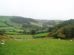
Once at the top of the hill the weather started to descend, and as the drizzle soon became rain I was forced to put my coat on. This had the added advantage of warming me up as I had not really noticed how chilly the stiff breeze was making me, and so I continued on as the path followed field edges down towards the farm at Lower Cefn-suran. On the way I passed a couple of farmers who were repairing a fence, and I chatted to them about the local area for a few minutes. At the time the weather was quite unpleasant with some driving rain, and as we sheltered in the lee of a tree I found myself thanking that my job is desk bound, and that I do not have to be out and about in such weather. From the farm another climb and descent took me to the Lugg Valley and into the little village of Llangunllo,
As I walked through the village I started to look for somewhere to get a water bottle filled up; although I had enough water for the rest of the day's walk, I did not really have enough for the night and the next morning's walk. I looked around for a couple of minutes but there was no real signs of any life in the sleepy village, and I was relieved when a car pulled up and a lady got out. I asked he for some water and it turned out that she was a local nurse coming to pay a visit to the local pub, the Greyhound. I had previously seen the pub and had assumed that it was shut, but as she led me in I could see that it was indeed open. Inside there was a crowded and dark interior, but there were signs everywhere that this was a loved place. The nurse filled up my water bottle for me, and I was then offered a pint. The landlord is in his nineties and apparently people pull their own pints! Unfortunately I could not really afford the time, so I gave the landlord a pound for his kindness and set off, newly encumbered by an extra two pints of water.
The Way followed a road for a short distance towards the railway line and Llangunllo railway station, before starting to climb steeply uphill. The weather was slowly worsening, and as I ascended the hill I started to get slowly soaked. Although In had my coat on I had not bothered to wear my waterproof trousers, and as I walked my right calf muscles started to tighten and ache. The wind also picked up, and I was glad when the path became a track as it headed westwards towards Upper Ferley.
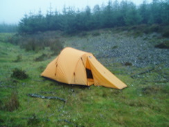
From here another good track headed uphill to the north, heading towards a patch of coniferous woodland on Beacon Hill. By this time In was firmly in a layer of cloud, and although it had been my intention to walk for a further three miles onto the top of Stanky Hill I decided that it would be a good idea to camp in some shelter. Therefore when the path reached the top edge of the trees I diverted through a gateway to the left and walked down another track for a hundred yards until I found a relatively flat spot. I had hoped to find a clearing in the trees, but the conifers were closely planted and there was no way obvious through the trees, and so I settled on the spot by the track.
The ground was rocky and I had some trouble getting some pegs into the ground, but eventually I had my tent erected and I could get in out of the miserable weather. By this time it was nearly dark, and I found that my socks and trousers were well and truly soaked. I stripped off and quickly got into my sleeping bag before listening to the radio for a couple of hours, before eventually letting the hypnotic sound of the wind whistling through the trees lull me to sleep.
Directions
|
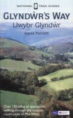
The walk is also covered in detail in the Glyndwr's Way National Trail Guide, by David Perrott, ISBN 1 85410 968 5, published by Aurum Press Ltd. Please click on the link to the right to access the Amazon page for the guidebok. |
|
Distances
| From | To | Distance (m) | Ascent (ft) | Descent (ft) |
|---|---|---|---|---|
| Knighton station | Knighton | 0.4 | 69 | 0 |
| Knighton | Llangunllo | 6.7 | 1608 | 1470 |
| Llangunllo | Beacon Hill | 3.7 | 955 | 207 |
This makes a total distance of 10.8 miles, with 2632 feet of ascent and 1677 feet of descent.
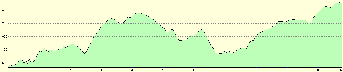
For more information on profiles, ascents and descents, see this page
Accommodation
I spent the night on my tent inside the woodland near Beacon Lodge, at about grid reference SO1907774775. I could not find anywhere to ask about staying here, and due to the weather I just put my tent up a few metres away from the track.
Disclaimer
Please note that I take no responsibility for anything that may happen when following these directions. If you intend to follow this route, then please use the relevant maps and check the route out before you go out. As always when walking, use common sense and you should be fine.
If you find any information on any of these routes that is inaccurate, or you wish to add anything, then please email me.
All images on this site are © of the author. Any reproduction, retransmissions, or republication of all or part of any document found on this site is expressly prohibited, unless the author has explicitly granted its prior written consent to so reproduce, retransmit, or republish the material. All other rights reserved.
Although this site includes links providing convenient direct access to other Internet sites, I do not endorse, approve, certify or make warranties or representations as to the accuracy of the information on these sites.
And finally, enjoy your walking!
This walk was mentioned in the following routes:
| Glyndwr's Way |
Nearby walks
| # | Title | Walk length (miles) |
|---|---|---|
| 182 | Knighton to Craven Arms | 15.3 |
| 690 | Glyndwr's Way: Beacon Hill to Abbeycwmhir | 22.2 |
| 763 | Kington to Spoad Hill | 20.4 |
|
|

|