Walk #704: A circular walk from Hadfield onto Bleaklow
 |
 |
|
General Data
| Date Walked | 29/12/2005 |
| County | Derbyshire |
| Start Location | Hadfield station |
| End Location | Hadfield station |
| Start time | 08.53 |
| End time | 14.26 |
| Distance | 13.5 miles |
| Description | This was an enjoyable walk, taking in the Longendale Trail from Hadfield, the Pennine Way over Bleaklow and the Doctor's Gate track back down to Glossop. |
| Pack | Today I carried my 30-litre Karrimor rucksack filled with my waterproofs, a book and various other odds and ends. |
| Condition | My right knee gave me a little trouble on the descent, and whilst this was not enough to cause me too much trouble it did slow me down on the rough sections. |
| Weather | Today was primarily a sunny day, with clear skies for much of the day and scarcely any cloud, It was a cold day, but there was not too much wind and so it made for a perfect winter's day for walking over the moors. |
| OS map | Outdoor Leisure number 1 (The Peak District - Dark Peak Area) |
 |
 |
|
 |
 |
|
Map of the walk
Maps courtesy of Google Maps. Route for indicative purposes only, and may have been plotted after the walk. Please let me have comments on what you think of this new format. For a detailed table of timings for this walk, please see the table file.
Notes
For the third year in a row a friend of mine, Mike, was up to stay for a few days over the Christmas period and as usual we decided to go for a walk. After studying the maps for a while we decided on a circular walk over Bleaklow from Hadfield, a walk that looked like it had a suitable combination of height and distance. Mike drove up the roads from Doveridge and a little over an hour later (due to quiet roads) we arrived at Hadfield station, where we parked and started to get ready for the walk. Overhead there was not a cloud in the sky, and so I decided not too wear my coat or waterproof trousers as the day looked so promising.
Immediately after we set off I discovered the unusual statue at the top of Hadfield's war memorial, a memorial made famous in the credits of the series 'League of Gentlemen'. Hadfield is the town where the series was filmed, doubling up as the weird and perverse town of Royston Vasey, and as I walked I looked out for other recognisable features, to little avail. This was probably because we were heading out of the town, and after a short distance we reached a car park that marks the start of the Longendale Trail. This trails follows the course of the former Woodhead railway line, a line that was closed in the early eighties for many reasons, not least of which was the decline of coal traffic between Sheffield and Manchester. It was a sad closure, and occasionally plans are launched to re-open the line, usually as part of a north-south high speed route.
I pondered about this as I walked along, Mike (who is far fitter than me) striding off ahead as I plodded along, studying the wonderful views over Bottoms Reservoir and Valehouse Reservoir. It had obviously been very cold overnight, and one of the bridges had long, thick icicles hanging down off the brick arch and the grass was crispy and crunched as we walked along. Ahead the hillsides to the north of the reservoirs were cast in a reddish glow from the rising sun, and the combination of these factors made the walk very pleasant. After a while he reservoirs disappeared from view behind trees, and the walk settled on being a gentle climb uphill along the well-surfaced track.
Eventually we reached the junction with the Pennine Way directly above the dam of Torside Reservoir, and the climb initially was an easy ascent up a track. After a short distance the Pennine Way headed off to the right, and a steep ascent started up the hill. As we climbed I could not help but keep on looking back over a majestic view of the reservoirs in a near=perfect sky, an uplifting sight that helped my feet get my body up the steepest part of the ascent. Fortunately this ascent did not last too long, and after a while the path started to climb gently along the southern edge of Torside Clough, and here the views looked equally superb, both up the clough and down towards the reservoirs.
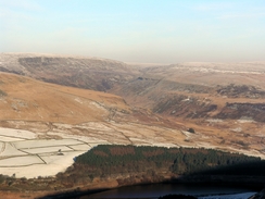
After a while the Pennine Way turned to the left to follow Wildboar Grain up to the summit, but instead we kept on along another path - rougher, but with better views - that follows a stream before curving up to the Wain Stones. On the way we got some superb views over Manchester to the west, and I could clearly make out tower blocks and power station cooling towers in the distance, Above all of these there was a dirty brown haze of smog, that was obviously being kept in by an inversion, and this was a graphic illustration of the pollution above the towns. As we approached the stones a mountain hare bolted in front of us, its white winter coat not being quite fully developed, with some darker patches of the summer coat showing through.
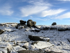
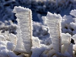
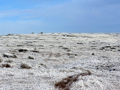
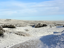
Mike arrived at the Wain Stones a minute or two ahead of me, and I found him sitting down on a rock near the stones. I ate my sandwiches as he had a snack, and all round there were glorious white scenes. Blades of tall bog grass had shimmering curtains of frost behind them, a sign of the fierce wind that must have been blowing across the top recently. Fortunately there was no sign of this wind, although after ten minutes we were both getting quite cold, and so we decided to head off. Mike set off first, and after calling him back as he was heading in the wrong direction, we set off together heading south across the moorland towards a rock outcrop called the Hern Stones. The walking was superb across the trackless terrain, the ground being frozen enough that we did not risk sinking into the bog underneath. At the Hern Stones we found the first people of the day, a large group of people, some of whom were wearing trainers and jeans - hardly suitable clothing for the area.
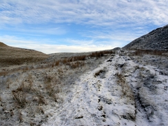
More climbing and falling through the numerous groughs took us to the Pennine Way near Hern Clough, and we then climbed up onto Alport Low. From here there were some more superb views, and we started heading down the distinct, wide path that led towards the Snake Pass. After the last few miles of pathless terrain this stretch felt like a motorway, and indeed the path was busy with many people walking up the hill by this, the easiest route. The generally unsuitable clothing many people were wearing made me feel remarkably overdressed, and so I was relieved when we reached the path that marked the start of the Doctor's Gate, a long track that leads down towards Glossop. The track was once a Roman Road, but as we descended down the steep sections it was difficult to imagine Centurions marching up and down the track.
It was not a hard walk but neither was it an easy one; a zig-zag took us down onto the flank of Crooked Clough, and then the track continued to slowly descend. In a couple of places on the higher sections the path was very narrow and a little care had to be taken in the icy conditions, but this situation improved as we descended and I found that I could spend more time looking around at the scenery. The track crossed Shelf Brook using a footbridge, and from here on it became wider and easier to walk along, which was a relief as my knee had started aching during the long descent. When the track forked we took the northerly branch, and we made good time along this wide and easy to walk track. This ended at a road, and a little road walking through the northern outskirts of Glossop took us towards Howard Park.
Here I gave Mike a choice of either a long road walk or a more direct footpath, and he chose the latter. This involved going up a steep hill towards a farm a Hilltop, and on the way Mike's foot broke through a layer of ice in a field and into a boggy area of ground. The muddy water overwhelmed his boots and got his feet wet - it was annoying to have this happen this near the end of the walk, having survived the usually boggy Bleaklow with dry feet. The path bypassed the mast on top of Mouselow Castle before starting to descend down into Hadfield. This descent was not too steep but it was slippery, and an area around a children's play area was exceedingly so. We passed this unscathed, and a short distance away we reached Mike's car at the station, and we could look back on what had been a thoroughly enjoyable stroll.
Directions
This walk starts off at Hadfield railway station. Leave the station and turn right, passing a pub on the left and with a railway embankment to the right. After a hundred yards the road curves to the right to pass under an old railway bridge; here turn left into a little car park and climb up join the Longendale Trail, which follows the course of the old Woodhead railway line. Walk along the trail for about two and a half miles, until the junction with the Pennine Way is reached above Torside Reservoir dam. Turn right and join the Pennine Way as it crosses a road and then starts to head up a driveway that leads towards the farm at Reaps. After a short distance, and before the farm is reached, leave the track by turning to the right and start ascending southwards along a footpath.
The path rises steeply onto Clough Edge, on the southern side of Torside Clough, and curves to take a more southeasterly and eventually easterly direction. Continue along the track until Wildboar Clough is reached at about SK081965; here you have a choice of either following the Pennine Way eastwards to Bleaklow Head, or you can continue on south-southeastwards along the clough. We chose to do the latter along a path that becomes increasingly indistinct as the clough ends; the path slowly curves to take a more easterly course before ending at the Wain Stones.
At the Wain Stones turn right and start heading south across the moorland towards the nest set of stones, the Hern Stones, about half a kilometre away. Keep the Wain Stones on the left and then curves around them to the south, heading southeastwards to rejoin the Pennine Way near Hern Clough. From here keep on the Pennine Way as it climbs up onto Alport Low, and then on as it descends southwestwards along a good, wide path to a junction with the Doctor's Gate path, a few hundred metres before the Snake Pass road is reached.
Turn right and join the Doctor's Gate path, following it as it descends down westwards for a couple of miles before ending at a junction of two tracks to the northeast of Mossy Lea Farm. Here turn right and head northwestwards along a good track that skirts around the northern side of Shire Hill before passing to the right of a large factory and ending at a T-junction with a road. Turn right up this road and follow it as it curves to the left past a church, The road takes a rough westerly course and when a junction is reached to the right turn right and follow this road westwards for a bout fifty yards until it ends at a T-junction.
Cross this road, and on the other side head straight on along a footpath that climbs uphill before ending at a residential road. Join this road and follow it as it heads northwestwards for about half a kilometre before ending at another road. Turn right along this road to head uphill for a few yards, and then turn left to head down another road, with Howard Park to the left. After about a hundred yards this road curves to the left; immediately after this bend turn right to join a footpath that heads uphill westwards to the farm at Hilltop. Once past the initial houses it is hard to find how the path crosses a hedge; there is a non-obvious stile and after this the climb up to the farm is easy.
Cross a stile and head straight through the middle of the farm; when a track is reached on the other side of the buildings turn right to join a narrow footpath that heads uphill between two fences. The fences end at a summit, and turn half-left to cross a field, slowly descending to another stile. AFter this turn left to descend down to some cottages at Mouselow, and then turn right to join a track that heads downhill to the north. Continue on along this track as it descends and do not take any paths leading off it; the gradient slackens and the track passes a children's play area before ending at a road in Hadfield. Turn left along this road and follow it as it immediately crosses a railway line; once on the other side turn right and take a footpath that heads down a slope to the car park of Hadfield railway station, where this walk ends.
Distances
| From | To | Distance (m) | Ascent (ft) | Descent (ft) |
|---|---|---|---|---|
| Hadfield | Wain Stones | 5.7 | 1894 | 400 |
| Wain Stones | Old Glossop | 5.9 | 346 | 1841 |
| Old Glossop | Hadfield | 1.9 | 359 | 358 |
This makes a total distance of 13.5 miles, with 2599 feet of ascent and 2599 feet of descent.
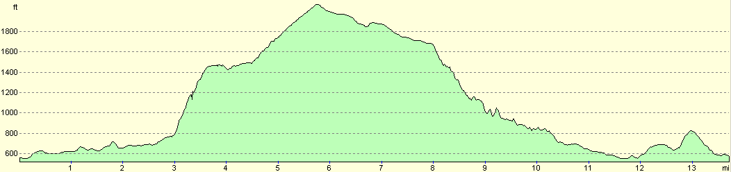
For more information on profiles, ascents and descents, see this page
Disclaimer
Please note that I take no responsibility for anything that may happen when following these directions. If you intend to follow this route, then please use the relevant maps and check the route out before you go out. As always when walking, use common sense and you should be fine.
If you find any information on any of these routes that is inaccurate, or you wish to add anything, then please email me.
All images on this site are © of the author. Any reproduction, retransmissions, or republication of all or part of any document found on this site is expressly prohibited, unless the author has explicitly granted its prior written consent to so reproduce, retransmit, or republish the material. All other rights reserved.
Although this site includes links providing convenient direct access to other Internet sites, I do not endorse, approve, certify or make warranties or representations as to the accuracy of the information on these sites.
And finally, enjoy your walking!
Nearby walks
| # | Title | Walk length (miles) |
|---|---|---|
| 13 | Edale and Kinder Scout | 11.0 |
| 19 | Castleton circular via Lose Hill and Mam Tor | 7.7 |
| 30 | Edale to Crowden | 16.5 |
|
|

|