Walk #641: A circular walk from Rugeley
 |
 |
|
General Data
| Date Walked | 01/01/2005 |
| County | Staffordshire |
| Start Location | Rugeley Trent Valley Railway Station |
| End Location | Rugeley Trent Valley Railway Station |
| Start time | 08.45 |
| End time | 14.46 |
| Distance | 18.7 miles |
| Description | This was an enjoyable walk, taking in part of the Trent and Mersey Canal, and the highest point of Cannock Chase. |
| Pack | Today I carried my 30-litre Karrimor HotRock rucksack, which was filled with three litres of water, a spare fleece, waterproofs and various electronic gadgets. |
| Condition | During this walk I have developed a slight hot-spot on my right foot (for the first time in while I did not wear a second pair of socks). I had no problems from my right knee, which has been aching during the previous two walks. |
| Weather | The forecast was for rain in the afternoon, but for the vast majority of the walk the weather was dry and even at times sunny. It was quite a mild day for the time of year, and the weather was mostly pleasant for a walk. The heavens opened when I was half a mile from the end of the walk, and I was quite glad that I was only out in the heavy rain for a short period. |
| OS map | Landranger number 128 (Derby & Burton upon Trent) |
 |
 |
|
 |
 |
|
Map of the walk
Maps courtesy of Google Maps. Route for indicative purposes only, and may have been plotted after the walk. Please let me have comments on what you think of this new format. For a detailed table of timings for this walk, please see the table file.
 |
Notes
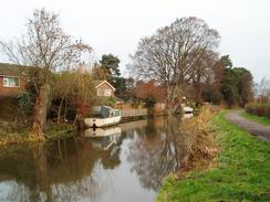
This was my last opportunity to do a walk in the Midlands before the end of my Christmas break, and I decided to do this circular walk so that a walk between Tamworth and Lichfield would complete a long walk from Braunston near Rugby to Rugeley. Unfortunately the weather forecast for today was for heavy rain in the afternoon, so I was relieved when I looked out of my window first thing this morning to find sunny patches in the sky. It is not a long drive from my parent's house to Rugeley, and I could therefore take my time before heading off. The car park at Rugeley Trent Valley railway station was deserted, and I parked my car off to one side, got my kit together and started heading of down the road. A little stroll of half a mile took me to the bridge over the Trent and Mersey canal, and I descended down and started following the towpath southeastwards. Initially the canal was dominated by the looming presence of Rugeley power station, the cooling towers seemingly visible from most places on the towpath. Rugeley is one of many power stations in the Trent Valley, with others being at Burton, Spondon, along with closed ones at Castle Donnington and Willington.
The Trent and Mersey Canal, which runs for 93 miles from the River Trent at Derwent Mouth to the Bridgewater Canal at Preston Brook, is one of the earliest major canals in the country. It was built between 1766 and 1777 (which included the construction of the one and three quarter mile long Harecastle Tunnel near Stoke), and was designed by the famous canal engineer James Brindley (although Hugh Henshall took over in 1772 after Brindley's death). I have always wondered about why the canal follows the Trent so far south to Rugeley, when another flat and potentially easy route could have been taken following the Dove Valley westwards from Burton-on-Trent towards Uttoxeter and then Stoke-on-Trent. Perhaps the supporters of the canal wanted it to visit the industries in the Rugeley and Lichfield areas, or perhaps there are engineering difficulties that I do not know about in the Dove Valley route. I was born in a house beside the canal in Stenson, near it's eastern end, and therefore I feel as if I have some form of personal link to this particular canal.
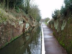
One thing I like about the Trent and Mersey canal are the cast-iron mileposts that appear every mile along the towpath. These are modern replicas of the original ones, and were erected by the Trent and Mersey Canal Association. Most of these have a plaque stating the donor who paid for the milepost, and I paused beside each of these as I passed them to read the plaques. There was not much else to note until I approached Armitage, where Hawkesyard Priory dominates the other side of the canal. This was built between 1900 and 1913 in Gothic style for a new foundation of Dominican Friars. Although an imposing building it was never completed to the original design, and the monks left in the 1980's. The building is now apparently a hotel, and it must be a very interesting place to stay. Shortly after this the canal entered a short and narrow defile, over which a bridge climbed over the top, forming a roof. It was interesting to see the marks made by workmen's tools on the rocks sides of the cutting, the marks having survived for nearly 230 years.
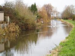
After Handsacre the canal became more rural and the bridges less frequent, and I thoroughly enjoyed the stroll down to bridge 53, with a lock right beside it. I was planning to leave the canal here using a short track marked on the map that leads a short distance to a road. Unfortunately when I reached the bridge I discovered that there was a house beside the track, and a warning notice stating that it was private. My alternative route would have taken me further along the canal to Fradley Junction and added about two and a half miles onto the walk, so I decided to sneak over a rope and head down the track. I did not get stopped, and soon found myself walking westwards along the road, heading past Black Sough Farm before reaching the A515 road. This was fairly busy and so I carefully walked south along it to the bridge over the Trent Valley railway line, and after that took a quiet lane towards the B5014. After a short distance along this road I came across Hanch Hall, and from the few glimpses of it I got from the road it seemed to be quite a nice stately home.
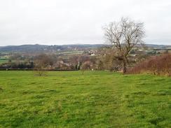
I went slightly off course by a couple of hundred yards on the footpath that led up the farm at Hill Top, although I found it easy to get back on course. The land here is reasonably high, and when I got to the trig point above Longdon I got some expansive views northeastwards over the Trent Valley. The trig point itself was situated by a gate and was surrounded by thick mud, so I did not spend too long looking at it before moving on down to the village of Longdon, and then I decided to change my route; I had planned to walk westwards to Upper Longdon, but I decided to walk along roads southwestwards towards Cannock Wood. This proved fairly simple, and included a narrow, oppressive road called Dark Lane that was quite atmospheric. At the top of the hill near Cannock Wood I came across a large waterworks structure, and from here the views to the southeast were quite nice. A short walk along roads through the small village of Cannock Wood took me to the highest point of Cannock Chase at Castle Ring.
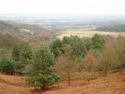
Castle Ring is a fascinating place; situated at the highest point of Cannock Chase, if it were not for the surrounding woodland it would have expansive views all around. Perhaps this is why Iron Age people chose to build this large, 260-metre diameter hill fort here over 2,000 years ago. Despite the fact that two millennia of erosion have occurred the bank is four metres high in places, and it must have been much more impressive when it was actually in use. The ring was abandoned in around AD50, and not much is known about why it was built or how it was used. Two similar hill forts, at Brownhills and on the Wrekin, would have been visible from Castle Ring, so perhaps it was part of a defensive structure. Due to the recent wet weather the outer ditch was filled with water in places, which perhaps gave me a better impression of how the fort would have looked when in use. I did not bother walking around the bank as I wanted to get on with the walk, but it is definitely a place that I am going to endeavour to visit on a sunny day so that I can have a closer look.
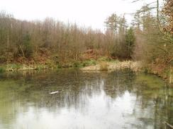
From the hill fort I had planned to follow the Heart of England Way as it heads north through the woodland of Cannock Chase. In theory this was an easy walk as the route follows a track, but unfortunately in practice it was harder - not only does the track descend down into a valley, but the track was also extremely muddy in places, having been churned up by walkers' boots and bike wheels. I managed to negotiate the first of these muddy sections with no problems, but when skirting the second of these my left boot sunk into thick, yellow gloopy halfway up to my knee. Fortunately I did not lose my balance, and I cursed as I pulled my foot out and walked down to the stream at the bottom of the hill to try and wash the worst of the mud off. This did not work very well, and this meant that my boots and the bottom of my trousers were covered in the yellow mud for the rest of the day. When the track approached the road near a campsite at Wandon I left the track, which was becoming muddy once more, and followed he road northwards for a couple of hundred yards to a large road junction.
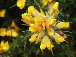
For the rest of the day I would be walking along roads, and a relative quiet road took me north uphill to a car park. On the map there was another trig point that I could visit, and I spent a couple of minutes looking for this in the thick gorse that lined the edge of the road before going back to the car park and finding it sitting in a little clearing. The views from the pillar were not particularly good, but if I walked a short distance I could get some fantastic views northeastwards over the Trent Valley. I could literally see for miles, and I could just make out the Weaver Hills to the north. After a few minutes I dragged myself away from the views, and started following the road northwards into Cannock. When the A460 was reached this became easier as a pavement started, and I followed this all the way into the centre of the town. I was surprised to find that this was deserted with no shops open; I was aware that it was New Years Day, but I half expected to find some shops open. As I walked northwards out of the town centre the clouds started to gather and by the time I reached the canal once again it started to rain heavily.
I already had my coat on, so I just put my hood up and walked on, realising that I only had another half mile to go before I reached the car. As I walked I was sure that I saw a flash of lightning in the distance, but as I did not hear any thunder I could not be sure. I was quite relieved when I reached the railway station and my car, and was also strangely elated at having completed almost the entire walk before the rains finally came. It had not been a classic walk as there had been a little too much road walking, but the canal stretch and Castle ring had both made up for the long road slogs.
Directions
This walk starts off at Rugeley Trent Valley Railway Station, just to the north of the town. Leave the station car park and head down the short access road to the B5013 Station Road, and then turn right along the B5013. It immediately passes under a railway bridge and reaches a bridge over the River Trent. Continue southwestwards along the road to a bridge over the Trent and Mersey Canal. Go down to the canal towpath and turn left, to head immediately under Bridge 67. Follow the canal for the next six and a half miles as it passes through Armitage and Handsacre, until Wood End Lock (no. 20) and the adjacent Bridge 53 is reached. Here I left the canal, going through the private grounds of the old lock house to gain access to a track that took me south to the road by Wood End Farm. However, note that this involves trespassing as this route is not a right of way, and if you want to avoid trespassing then you will need to continue along the canal for another mile to Fradley Junction, which will add another couple of miles onto the walk.
Once at the road (called Wood End Lane) turn right and start follow it westwards for a couple of kilometres, passing Black Sough Farm before it finally ends at the A515 road by Vicar's Coppice. Turn left to walk south along the A515 for a short distance as it climbs to cross a railway line on a bridge, and immediately on the southern side of the bridge turn right to walk westwards along a quiet lane. Initially this skirts the railway line for a few yards, before curving to the left to reach the B5014 Lichfield Road. Once at the B5014 turn right and follow it northwestwards for a couple of hundred yards until a road leads off to the left. Follow this for a short distance as it passes an entrance gateway to Hanch Hall, and when the road curves to the left take a footpath that heads straight on through a little gate. Continue along the path for as it heads across a small field, and when it reaches the northern corner of a patch of woodland take a more northerly course, aiming immediately to the right of the farm at Hill Top.
The path skirts immediately past the farm, and continues on along an easy-to-follow path. This skirts a trig pillar before descending westwards towards some houses on the outskirts of Longdon. Once the houses are reached the path turns sharply to the left, and heads southwestwards before ending at a road. Turn left down this road for a few yards until it ends at Brook End; turn left along this road for another couple of yards until the A51 is reached. Carefully cross the A51 and once on the other side start following Borough Lane southwestwards. After a little over a kilometre turn left down Dark Lane; this passes Darklane Farm before ascending along a narrow track enclosed on both sides, until it ends at a crossroads. Continue straight on, heading southwestwards along Thorley's Hill; this dips down into a deep little valley and once on the other side the road becomes Malthouse Road. Immediately after a road junction on the left with Windmill Lane turn right along a footpath that crosses a field northwestwards before passing a waterworks and reaching Holly Hill Road in the little village of Cannock Wood.
Continue along the road westwards until a pub is reached on the left. Turn right and enter a car park, and start following the Heart of England Way as it heads northwards, initially skirting past the imposing earthworks of Castle Ring. The path follows a muddy track that descends into a valley before climbing up the other side; it then skirts a road before reaching a road junction at Wandon, where this route leaves the Heart of England Way. Here take Stile Cop Road, which heads off half-left to head northwards uphill. At the top of the hill there is a car park, next to which is a trig pillar. From the car park the road continues to descend to the north, passing a cemetery on the right before ending at the A460 Hednesford Road. Turn right and follow the A460 as it heads northeastwards towards the centre of Rugeley. It crosses a railway line on a bridge near Rugeley Town station before a roundabout is reached. At the roundabout continue straight on, heading north along a pedestrianised road.
Once an imposing building is reached on the left (the old market hall) turn left and walk westwards for a short distance along a road until the B5013 is reached. Turn right and follow the road northwards to a junction; here continue on northwards along the B5013 as it passes two churches (the one on the left a ruin, the one on the right intact) and reaches a bridge over the Trent and Mersey Canal. From here it is simply a case of retracing the initial half-mile of the day's walk, heading northwards across the Trent and under a railway bridge before turning left to head up the access road to Rugeley Trent Valley railway station, where this walk ends.
Distances
| From | To | Distance (m) | Ascent (ft) | Descent (ft) |
|---|---|---|---|---|
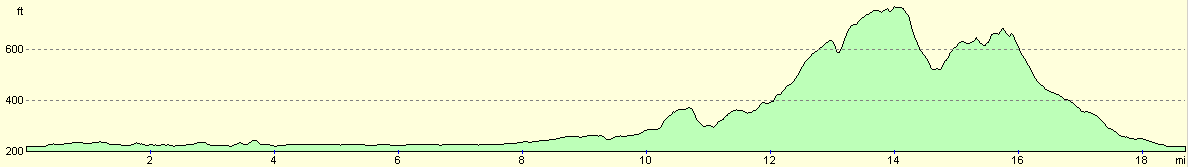
| Rugeley Trent Valley Station | Bridge 53 | 7.4 | 151 | 144 |
| Bridge 53 | Castle Ring | 6.6 | 717 | 190 |
| Castle Ring | Rugeley Trent Valley Station | 4.7 | 253 | 787 |
This makes a total distance of 18.7 miles, with 1121 feet of ascent and 1121 feet of descent.
For more information on profiles, ascents and descents, see this page
Disclaimer
Please note that I take no responsibility for anything that may happen when following these directions. If you intend to follow this route, then please use the relevant maps and check the route out before you go out. As always when walking, use common sense and you should be fine.
If you find any information on any of these routes that is inaccurate, or you wish to add anything, then please email me.
All images on this site are © of the author. Any reproduction, retransmissions, or republication of all or part of any document found on this site is expressly prohibited, unless the author has explicitly granted its prior written consent to so reproduce, retransmit, or republish the material. All other rights reserved.
Although this site includes links providing convenient direct access to other Internet sites, I do not endorse, approve, certify or make warranties or representations as to the accuracy of the information on these sites.
And finally, enjoy your walking!
Nearby walks
| # | Title | Walk length (miles) |
|---|---|---|
| 171 | Doveridge to Abbots Bromley | 9.7 |
| 569 | Abbots Bromley to Stafford via Rugeley. | 16.0 |
|
|

|