Walk #594: A circular walk between Bottesford and Bingham
 |
 |
|
General Data
| Date Walked | 28/02/2004 |
| County | Leicestershire, Nottinghamshire |
| Start Location | Bottesford Station |
| End Location | Bottesford Station |
| Start time | 07.44 |
| End time | 14.03 |
| Distance | 19.2 miles |
| Description | This was a reasonably enjoyable circular walk, although it was scenically fairly nondescript and had a little too much road walking for my liking. |
| Pack | Today I carried my 30-litre Karrimor HotRock rucksack, which was filled with my waterproof leggings, water bottle, trainers and a couple of spare shirts, together with the usual assortment of odds and ends. |
| Condition | I feel absolutely fine after this walk, and I could easily have walked further if I had needed to. I have no blisters, and my feet and legs are both fine. |
| Weather | The weather today was quite like the walk - nondescript. The skies were mainly sunny, although clouds did make an appearance later on. The wind was biting and cold, although I was fortunately not exposed to it for most of the time. |
| OS map | Landranger number 130 (Grantham, Sleaford & Bourne) and Landranger number 129 (Nottingham & Loughborough, Melton Mowbray) |
Map of the walk
Maps courtesy of Google Maps. Route for indicative purposes only, and may have been plotted after the walk. Please let me have comments on what you think of this new format. For a detailed table of timings for this walk, please see the table file.
Notes
After the walks that I had done over the last couple of weekends I had an eight-mile gap left to finish off my walk from Boston to Bingham, Eight miles was far too short a walk, so I decided that I would do a circular walk to extend the distance a great deal. I also wanted to nip into Derby so that I could have a haircut and buy some birthday presents prior to a party tomorrow, so I had to have a very early start.
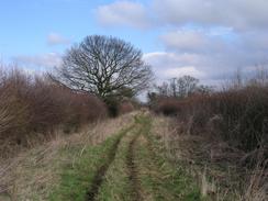
I arrived at Bottesford as the sun was low in the sky, and there was a thick frosty lying on the ground, associated with odd patches of sky. I locked the car up and passed a lone jogger before crossing the railway line and heading up a track that led towards a trig point. The views from the trig point were very nice despite the fact that it was not too high; I could see Belvoir castle in the distance to the south, and I could see a long way to the east as well. I descended down across a field to meet a road, where I passed the jogger once again - she had covered a much greater distance than me!
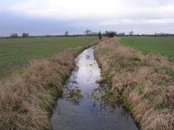
The path was easy to follow as it headed northwards over fields, with the Lincolnshire County Council having out yellow blazes onto the top of posts, making them easy to see across the wide fields. The River Devon was not really worthy of the name, being more of a trickle running down a drainage channel than a fully-fledged river, but it marked the end of the footpath with only a short distance to go to reach the church in Kilvington.
A long road walk followed as I headed southwestwards along a road through Alverton towards Orston. Early on I passed over a disused railway line that is marked on the map as having a path running along it. I had been planning to use this path on a future walk to go from Bottesford to Newark, but unfortunately to the north of the road the old railway bed was obliterated by some large mining operations of some kind. I do not know what they were quarrying, but the works were exceedingly large and there were many large earthmovers moving tons of earth around.
In Orston I walked past the attractive church before heading on a more westerly course, still following a road that climbed over Speller Hill (a mere little bump) before ending at a T-junction to the northeast of Scarrington. I walked past another attractive church, and the village itself was quite pretty. By this stage I was getting fairly fed up with all the road walking, so I was glad that the next section was along a footpath all the way into Bingham. The path did not start well as I could not find the start of he path in the village, but I made my own way by walking slightly further southwards before turning right and crossing a small field to gain access to a track.
I had visited Bingham a couple of weeks before, and it was nice to be back in the village. It has a very prominent and extremely elegant butter cross, which is well set off in the middle of the square. I made a bee-line for the Birds shop on the other side of the square, where I bought myself a couple of pork pies and a sausage roll - good fuel for the rest of the walk. I then walked through the churchyard past the church, which I know quite well and is quite a landmark. After crossing an area of wasteland (actually the site of a medieval village called Crow Close, the house outlines still just discernable on the ground - it is strange to think that people lived in this field for over 600 years before the village was abandoned) I went past a school and joined another path.
The footpath was obvious as it headed across fields to end at a road beside a level crossing over a railway line. I crossed the line, and then went to take a footpath that ran through the farmyard of Abbey Farm. The path was well signposted through the yard, but there was an area that had newborn lambs in it, and so I decided not to disturb them and went back to the road and walked along the road instead. I soon found myself in Aslockton, which I had not been to for some time, and I passed the station and crossed the River Smite before entering the adjacent village of Whatton.
From Whatton another track took me northeastwards for a couple of miles towards the railway line. The track ended at a ploughed field and I cut my way diagonally cross it towards the obvious bridge under the railway line. Unfortunately I should have followed the edge of the field, as I found my way blocked by a steep-sided drainage channel, which was guarded on the other side by a thick hedge and wooden fence. I was determined not to walk back, so I carefully made my way down the side of the channel before climbing up the other. I emerged onto the track by the bridge with large scratches on my hands and thorns in my hands and wrists - a sure example of a case where it would have been better to run back and find the path proper!
Fortunately once I had passed under the railway line the track was easy to follow as it headed northeastwards into Orston. Rather than rejoin the route that I had followed earlier in the day, I turned right just before I entered the village and crossed a field uphill to a trig point from where there were some fairly expansive views. The last three miles of the walk were along a road, passing a noisy gun club before entering Bottesford. At the Bull Inn in the village I was surprised to find a sign stating that Stan Laurel and Olive Hardy stayed at the Inn whilst appearing at the Empire Theatre in Nottingham in 1952 - it turns out that Stan Laurel's sister ran the Inn at the time! This village is very nice, and the ford in front of the church was an extremely pretty sight; even the ducks used the little pedestrian bridge to cross the stream! The church has a tall and slender spire that is a landmark for quite a distance around. I soon reached the car, relieved at ending another walk but feeling quite fine - it was hardly a classic walk, but was certainly worth doing.
Directions
This walk starts off at Bottesford railway station. Leave the car park and turn right for a few yards until a little level crossing is reached on the right. Cross the railway line and take the track that heads uphill to a wooden beacon and trig point. Walk slightly beyond the trig point until a field boundary is reached; here a path leads off to the half-left, crossing a file diagonally before ending at a road in Normanton. Once at the road turn left and follow he road as it curves sharply to the right and then the left; shortly after the left-hand bend take a footpath that heads off to the right. This footpath heads northwards across a field, passing a telegraph post before entering another field. The path then settles on a northerly course as it crosses many fields, eventually reaching the River Devon. Cross the river and continue on northwards for a short distance to a drainage channel, where the path turns to the left to head in a more westerly direction before reaching a road near Kilvington Church.
Turn left and follow the road as it heads past the church; it continues on southwestwards, crossing over an old abandoned railway line and heading through Alverton. At Lodge Farm the road curves to the right and then the left, before resuming a southwesterly course for another kilometre. The road finally curves to the right with a beacon on the hillside to the right; when the road curves to the left continue straight on along a minor road that leads into Orston. When this road ends at a T-junction turn left and then take the next road to the right, which heads westwards past Orston Church before crossing the River Smite and heading up to the top of Speller Hill. Another mile further on the road ends at a T-junction; turn left and follow another road that heads southwestwards for a few hundred yards before ending at a T-junction beside Scarrington Church.
At the T-junction turn right and follow a road as it curves slowly to the left; near the Methodist church the map shows a footpath leading off to the right; I could not find where this path started, so I continued along the road a little further until a drainage channel is reached just outside the village; I then turned right to follow the northern side of this channel. After going through a hedge and over a fence I joined a track, which allowed me to gain access to the footpath proper. The path then winds around, heading in a rough west-southwesterly direction until it meets a track that leads up towards Holme Farm. From here head southwestwards, aiming for the prominent footbridge over the railway line at Bingham Station, crossing some playing fields on the way. Once the footbridge is reached cross the railway line to gain access to the centre of Bingham.
Go to the station forecourt and then walk south along Station Lane to the market square in Bingham, with the Butter Cross prominent. Walk past the cross and then turn left to walk eastwards along Church Street; when this turns to the right go through a gate and walk eastwards through the churchyard, passing the church on the way. Go through the gate at the other side of the churchyard and join a road for a few yards before turning right down Fosters Lane for a few yards until it ends at a T-junction. At the junction turn left to head eastwards along Long Acre Lane East; this road eventually curves to the left and becomes Cogley Lane; a few yards along this road turn right along a footpath that crosses the old site of Crow Close and reaches the grounds of a school. The path skirts past the side of this school before reaching fields on the very eastern outskirts of Bingham.
The path is easy to follow as it heads eastwards under a set of power lines, and fairly soon afterwards it reaches another set of lines. Here the map shows the path turning to the left to head northwards, but on the ground a distinct footpath continued straight on before ending at a road. Once at the road turn left and follow it as it heads northeastwards to a level crossing over the railway line near Abbey Farm; cross the railway line and continue on for a short distance until the road ends at a T-junction. Here turn right and follow the road as it heads eastwards into the village of Aslockton. At a T-junction turn right to cross the railway line using a level crossing beside the railway station and continue on to a bridge over the River Smite. Follow the road as it heads southeastwards through Whatton; when the road curves to the right to head southwards take a footpath that heads off to the left.
The footpath follows a track, initially heading east before curving to head in a more northeasterly direction. It crosses the River Whipling (which is little more than a drainage ditch) before it ends at a ploughed field. Do not do as I did and cut across the field because there is a drainage ditch between the field and the bridge under the railway line; instead turn to the right and follow the edge of the field. When the eastern edge of the field is reached turn left and join a track that leads to the bridge under the railway line. On the other, northern, side of the railway line turn right to join a continuation of the track. This heads northeastwards for about a kilometre, slowly becoming firmer under foot until it eventually becomes surfaced on the outskirts of Orston. Shortly after the track become surfaced and houses begin, take a footpath that leads off to the right; this path heads diagonally uphill to the south across a field before it ends at a road near to a trig point.
Join the road and turn left to walk a short distance to a triangular junction. Here turn right and follow a road that heads east-southeastwards for two and a half miles, passing a gun club and crossing the railway line for a final time before reaching the western outskirts of Bottesford. When the road curves sharply to the right continue straight on down Bowbridge Lane. This continues on for a few hundred yards before reaching the High Street; continue on eastwards down High Street until it ends at a T-junction with Market Street; at this junction turn left down Market Street and pass the Bull Inn. Cross the stream beside the church and then take a footpath that leads off to the right; skirting the churchyard before a pond is met. Turn to the left past the pond to head northwards along a path that leads up to Station Road; when the road is reached turn right and follow Station Road eastwards for a few yards to Bottesford Station, where this walk ends.
Distances
| From | To | Distance (m) | Ascent (ft) | Descent (ft) |
|---|---|---|---|---|
| Bottesford railway station | Bingham railway station | 10.1 | 200 | 246 |
| Bingham railway station | Bottesford railway station | 9.1 | 210 | 164 |
This makes a total distance of 19.2 miles, with 410 feet of ascent and 410 feet of descent.
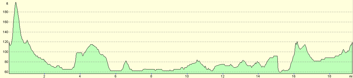
For more information on profiles, ascents and descents, see this page
Disclaimer
Please note that I take no responsibility for anything that may happen when following these directions. If you intend to follow this route, then please use the relevant maps and check the route out before you go out. As always when walking, use common sense and you should be fine.
If you find any information on any of these routes that is inaccurate, or you wish to add anything, then please email me.
All images on this site are © of the author. Any reproduction, retransmissions, or republication of all or part of any document found on this site is expressly prohibited, unless the author has explicitly granted its prior written consent to so reproduce, retransmit, or republish the material. All other rights reserved.
Although this site includes links providing convenient direct access to other Internet sites, I do not endorse, approve, certify or make warranties or representations as to the accuracy of the information on these sites.
And finally, enjoy your walking!
Nearby walks
| # | Title | Walk length (miles) |
|---|---|---|
| 66 | Melton Mowbray to Bingham | 16.1 |
| 76 | Bingham to Nottingham | 13.5 |
| 593 | Sleaford to Bottesford | 23.3 |
|
|

|