Walk #593: Sleaford to Bottesford
 |
 |
|
General Data
| Date Walked | 21/02/2004 |
| County | Lincolnshire, Leicestershire |
| Start Location | Sleaford Station |
| End Location | Bottesford Station |
| Start time | 08.47 |
| End time | 16.24 |
| Distance | 23.3 miles |
| Description | This was a long and fairly uninteresting walk westwards from Sleaford to Grantham, which was followed by a much nicer stretch to Bottesford. |
| Pack | Today I carried my 30-litre Karrimor HotRock rucksack, which was filled with my waterproof leggings, water bottle, trainers and a couple of spare shirts, together with the usual assortment of odds and ends. |
| Condition | For some reason I have suffered slightly after this walk - both of my feet have hotspots, and for the last couple of miles they were quite painful and I had to grit my teeth to get through. I also feel not on top form, and am quite glad that the walk is over. |
| Weather | The forecast was for there to be sunny skies today, but this never really materialised as there was a thin cloud layer overhead. Fortunately there was no sign of any rain at all during the day, and I was sheltered from the cold wind for the majority of the day. |
| OS map | Landranger number 130 (Grantham, Sleaford & Bourne) |
 |
 |
|
Map of the walk
Maps courtesy of Google Maps. Route for indicative purposes only, and may have been plotted after the walk. Please let me have comments on what you think of this new format. For a detailed table of timings for this walk, please see the table file.
Notes
As part of a follow-up to last Saturday's walk from Boston to Sleaford, I decided that this weekend I would continue westwards. When I had planned this little walk a few yards ago I had intended to walk to Grantham, but at only thirteen miles that was too short for me to contemplate. I tried looking on the map for an enjoyable longer route to Grantham, but there was not really anything obvious. For that reason I decided to extend the walk by going on for another nine miles to the station at Bottesford. There are not many trains from Bottesford to Sleaford, so I decided to drive to Bottesford early in the morning and get the second train to Sleaford and start the walk from there. I arrived at Bottesford Station twenty minutes before the train was due, and I spent the time chatting to Sam on the phone - she is due back from Australia in three weeks, and I am missing her a great deal.
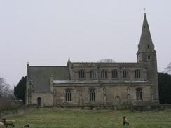
When the train finally arrived at Sleaford I was very glad that the weather was far better than it had been last week. I started off walking away from the station but I soon had to stop to let the train go across the level crossing. The walk up to Silk Willoughby was along a fairly quiet road, and on the way I passed an elegant carved tree on the right. I was annoyed not to be able to get a good photograph of the church at Silk Willoughby - the sun was in the wrong direction and I could not be bothered walking around to the other side of the church to try and get a better angle. I walked down School Lane, passing the school and the Butt Mound (a strange name for a round barrow - I wonder if it may have been used for archery in times gone by?). I really chose the wrong route through the village as I was forced to join the A15 for a few hundred yards, and it would have been better to take the minor road that runs through the village instead.
On the next stretch of path across fields towards Culverthorpe I came across the remnants of a children's balloon, burst on the recently cut hedge. Tied to the ribbon of the balloon was a note, written in a child's handwriting that went: "1st February 2004. To Peter, I went to see you at the cinema and I thought you was great. Please can you came to my house and tap on my window and I'll open it for you and leave it on my window-sill, for you on Valentine's night! Lot's of love and kisses, Shannon x". As I read the note I started wondering about who Shannon and Peter were, and how the balloon ended up in a hedge in remote Lincolnshire. I found it quite poignant, and I whiled away the next few miles thinking about them. Unfortunately the path underfoot across the fields was very indistinct, and I could not find the crossing place of a little stream in the valley, which meant that I had to do a jump across.
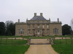
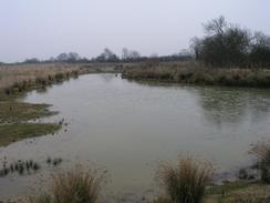
I was very impressed with Culverthorpe Hall, a massive stately pile of a place with two detached wings. The stone building was very attractive, and appeared to be quite unspoilt. I was nice to see that the owners were also very walker friendly, and had created walking routes through the grounds - top marks to them. The track through the grounds passed two nice lakes before dumping me out unceremoniously on a road, whish I followed westwards for a few miles. The walk down and into Grantham was fairly unspectacular, and was on roads except for short stretches to the east and west of Londonthorpe. I put myself on autopilot as I walked along the roads, and soon found myself passing the beautiful Town Hall and the decidedly less beautiful bus station. Back on autopilot, I walked for another couple of miles to the A1 bridge, and the start of the Grantham canal.
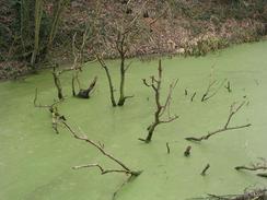
This first stretch of the Grantham Canal is meant to be navigable thanks to the good work of the Grantham Canal Restoration Society. Unfortunately it appeared to be anything but navigable - the initial stretches of the canal from the A1 was covered in a thick layer of green slime that reflected the sun so well it appeared shiny, and there were many branches sticking out of the water. The restoration of the canal is being done in what seems to me to be a very odd manner, with three separate stretches now navigable. These stretches are not adjoining, which means that not only are boats currently unable to get to the main canal network, to get from one part of the Grantham canal to another they have to be lifted out of the water and transporter by road! I would have thought that a plan to extend one initial stretch would have been much more successful, rather than the piecemeal approach they have taken. Although restored this stretch of the canal looked abandoned, and there was not a single boat on it, although to be fair it is out of the usual boating season.
I found the walk along the canal to be the nicest of the entire walk, and it was only slightly spoilt by the fact that my feet were aching a great deal, in particular my left foot, which appeared to have one or two hotspots developing. I put this out of my mind, however, and concentrated on spotting as many of the mileposts as I could. Unusually as well as having posts every mile, the canal society had placed them every quarter mile as well, so I took some enjoyment at spotting them every five minutes as I ambled along. There was also abundant wildlife to be seen as I strolled, and I was reminded that canal side walking, whilst not necessarily being the most scenic walking, is nonetheless a very pleasant way of spending the afternoon. I passed three restored locks, and these were followed by three unrestored ones that had been converted into weirs. At Woolsthorpe the canal was joined by an old railway trackbed that used to service quarries in the area, and the cycle path diverted onto that.
Eventually I reached the point where I had to leave the canal towpath, and so I started walking along the old railway trackbed as it started to curve northwards towards Muston. The cycle path soon left it, but I found that I could continue on along an obviously well walked path. A footpath then took me northwestwards towards the attractive little church in the village, across fields where some young cows took an inordinate amount of interest in me! The majority of the last couple of miles from Muston to the station in Bottesford was long roads, and this made my tired feet ache even more, and so it was with some gladness that I reached Bottesford. I nipped into the local petrol station to buy a chocolate bar and a packet of crisps, which I ate during the last few hundred yards to the station. Once I got there I was quite relieved that the walk was over, and although it had been a fairly enjoyable day the trouble with my feet had put a dampener on what should have been the best stretch of the walk.
Directions
This walk starts off at Sleaford railway station. Leave the station and turn right to walk eastwards for a few yards up Station Road, passing the bus stops before the road ends at a complex junction. Turn right and cross over the railway line on a level crossing, and one on the other side turn right to walk westwards along the B1517 road. Just before a shop is reached on the right turn left down London Road. This road heads southwestwards out of Sleaford and climbs over Stump Cross Hill before reaching the church in the little village of Silk Willoughby.
In Silk Willoughby turn right at the small village cross down School Lane. This heads westwards past a Butt Mound before turning to the left through a farm and then to the right to meet the A15 road. Turn left and walk south along the A15 for a few hundred yards until a road junction is reached on the left. At this junction turn right along a footpath that heads westwards across fields; the path is very indistinct on the ground but initially follows a hedge before turning to the left to head southwestwards. Near some ponds the path crosses a stream; I could not find the path here so I just jumped across it. From the stream I continued southwestwards, aiming for the left-hand edge of a patch of woodland in the distance.
Once I reached the southwestern corner of the woodland I turned left to walk south along a bridleway for a short distance before turning right along a footpath that headed through a hedge. The path heads westwards, skirting past a farm before ending at a road just to the north of Culverthorpe. Turn left and follow the road southwards for a hundred yards until a T-junction is reached; here turn right and walk the short distance to some grand gates guarding the entrance to the grounds of Culverthorpe Hall. A pedestrian gate to the right allows access to a surfaced driveway that leads past the front of the hall before turning to the left past a farmyard. The track then winds between two lakes before reaching another imposing gate. This was locked, but a path off to the left led through to a car park and the road.
At the road turn right and follow it as it heads southwestwards towards Oasby. In Oasby it turns onto a more westerly heading, passing the stump of an old windmill before eventually reaching Welby. Walk past the church and continue onwards until the road ends at a T-junction with the B6403 road. Cross the road and on the other side take a footpath that heads westwards across a field for a few hundred yards before turning to the left towards an unsurfaced track. At a field boundary turn right to walk westwards for a few yards, and then to the left to walk southwards. The path then makes a final turn to the right and diagonally crosses a paddock before ending at a road in Londonthorpe.
Once at the road turn right and walk westwards through the village. At a road junction turn left for a few yards until a track leads off to the right; at the track turn half-right through a hedge to gain access to a path across a field. The path is impossible to find on the ground, but head southwestwards aiming for a large electricity pylon. Once at the pylon continue onwards to the southwest aiming for the edge of Alma Wood. The path reached the edge of the wood just past a hedge, and then dives down through the narrow bend of woodland before crossing a field and passing a chain-link fence.
The path ends at Alma Park Road in the middle of an industrial estate. Turn left to head southward down a road, and when the road ends at a T-junction turn right down Harrowby Lane. The lane heads westwards for about a kilometre before a little mini roundabout is reached; at the roundabout turn left to head southwards down New Beacon Road. After a little under a kilometre the road curves to the right to head westwards to a crossroads beside the Barracks. Head straight across, following Stonebridge road that descends down to cross the River Witham before climbing up to end at a T-junction with the B1174 road beside the imposing Town Hall.
Turn left to walk along the B1174 road for a short distance before turning right to walk westwards along the A52 Wharf Road. This passes a bus station and shopping centre before reaching a complex junction beside a viaduct that carries the East Coast Main Line through the tow. At the junction turn half-left to follow Harlaxton Road south-southwestwards for a kilometre, where it joins the A607. Continue onwards as the road heads towards and eventually passes under the A1(T). Once on the other side of the A1(T) turn right down a path that heads north for a few yards along the A1(T) embankment, and crosses over the end of the Grantham Canal.
Once at the canal turn left and follow the canal towpath as it winds its way westwards for over four miles; the towpath remains on the northern side of the canal for the entire way, and shares the towpath with National Cycle Route 15. Near some locks the cycle path joins an old railway trackbed that borders the canal, and this can be followed as it curves away from the canal to the north of Stenwith. The cycle path meets a road that heads northwestwards towards Muston; I stayed on the railway trackbed that is not a public right-of-way, but there is a clear and distinct path through the undergrowth.
The embankment passes over a stream; immediately after the bridge a footpath leads off to the left, heading northwestwards across a field towards Muston Church. The path enters the churchyard and heads path the church before meeting a road opposite a road junction. Head straight on along a road that heads northwards before curving sharply to the left for a short distance. When the road curves to the right after a short distance continue straight on down a track for a few yards before turning to the right to take a footpath that heads northwestwards across a field before reaching the A52(T).
Cross the A52(T) and once on the other side follow a short piece of old road that meets Grantham Road . This heads northwestwards for over a mile towards Bottesford. The road enters the village and passes a petrol station on the right; shortly after this turn right down Station Road. The station is a few hundred yards down this road on the right.
Distances
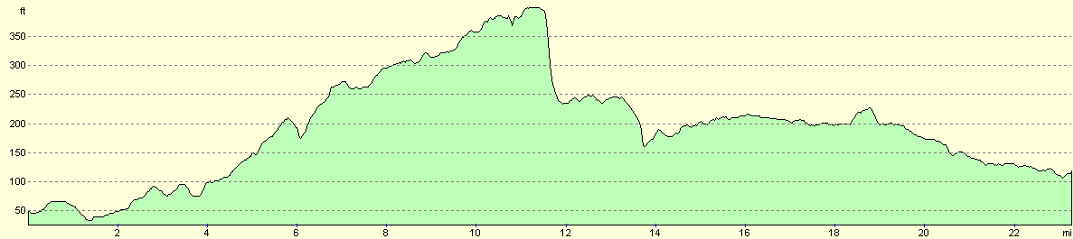
| From | To | Distance (m) | Ascent (ft) | Descent (ft) |
|---|---|---|---|---|
| Sleaford Station | Oasby | 7.2 | 344 | 135 |
| Oasby | Grantham | 7.1 | 266 | 348 |
| Grantham | Bottesford Station | 9.0 | 174 | 233 |
This makes a total distance of 23.3 miles, with 784 feet of ascent and 716 feet of descent.
For more information on profiles, ascents and descents, see this page
Transport
There are some rail services running from Bottesford to Sleaford, with a single ticket costing £3.80. Note that not all of these trains call at Grantham, although there are some rail services run between Grantham and Bottesford.
Disclaimer
Please note that I take no responsibility for anything that may happen when following these directions. If you intend to follow this route, then please use the relevant maps and check the route out before you go out. As always when walking, use common sense and you should be fine.
If you find any information on any of these routes that is inaccurate, or you wish to add anything, then please email me.
All images on this site are © of the author. Any reproduction, retransmissions, or republication of all or part of any document found on this site is expressly prohibited, unless the author has explicitly granted its prior written consent to so reproduce, retransmit, or republish the material. All other rights reserved.
Although this site includes links providing convenient direct access to other Internet sites, I do not endorse, approve, certify or make warranties or representations as to the accuracy of the information on these sites.
And finally, enjoy your walking!
Nearby walks
| # | Title | Walk length (miles) |
|---|---|---|
| 66 | Melton Mowbray to Bingham | 16.1 |
| 592 | Boston to Sleaford | 19.2 |
| 594 | A circular walk between Bottesford and Bingham | 19.2 |
|
|

|