Walk #385: Castlemartin to Pwllcrochan
 |
 |
|
General Data
| Date Walked | 16/03/2003 |
| County | Dyfed |
| Start Location | Castlemartin |
| End Location | Pwllcrochan |
| Start time | 09.17 |
| End time | 16.02 |
| Distance | 15.9 miles |
| Description | This was another highly enjoyable day, and one that even the dubious scenic delights of oil refineries could not lessen. |
| Pack | Today I carried my 30-litre Karrimor HotRock rucksack, which was filled with my packed lunch, waterproof leggings, water bottle and a couple of spare shirts, together with the usual assortment of odds and ends. |
| Condition | I found today quite hard, which is quite strange as although some of the work was quite hard the rest of it was far easier. I really ran out of energy at the end of the day, and the last few miles took more mental effort to get over the fact that I had no physical energy left. Physically I am fine and have no significant aches or pains, but I am drained from lack of sleep last night. |
| Weather | Today's weather was more or less identical to yesterdays, with lovely sunshine lasting all day and only a few clouds to be seen. Unfortunately the weather forecaster who said that the wind would die down was wrong, and it wad as windy today as it was yesterday, which was annoying when I was exposed to it on the cliff tops. I cannot complain too much, however, as it was another dry day, and when this is compared to the week before last it can only be seen as a good thing. |
| OS map | Landranger number 158 (Tenby & Pembroke) |
 |
 |
|
 |
Map of the walk
Maps courtesy of Google Maps. Route for indicative purposes only, and may have been plotted after the walk. Please let me have comments on what you think of this new format. For a detailed table of timings for this walk, please see the table file.
Notes
I got off to a bad start today, as I found it very hard to get to sleep last night, and woke well before dawn today. This all added up to the fact that I had very little sleep last night, and this made me exceedingly tires during this walk. I think that this also meant that I found the walk today much harder than it should ordinarily have been, and by the time that I reached the church at unpronounceable place name of Pwllcrochan I had absolutely no intention to extend the walk as I had planned.
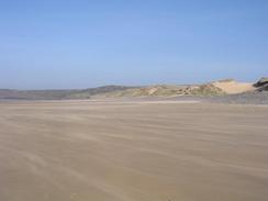
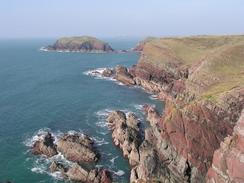
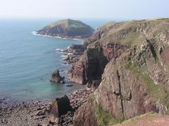
The section of path between the beautiful beach at Freshwater West and West Angle Bay was quite spectacular, with some great views along the cliffs. In particular the area around Sheep Island was superb, with the heavily folded cliffs looking like a layered cake, the red sandstone being the jam filling. This section was also much harder than I had been expecting it to be, with many steep ascents and descents to be made, but the spectacular scenery more than made up for this. Indeed I stopped more to look at the scenery than I did for rests, as none of the ascents were too long.
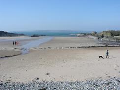
I stopped to have lunch at West Angle Bay, and I sat down on the little concrete slipway to get out of the annoyingly strong and gusting wind. As I ate a couple were walking around the top edge of the beach near me collecting large pebbles in buckets, so I asked them what they were doing. They had just built a pond in their garden, and they needed the pebbles to concrete in around the edge of the pond as a feature. I thought that the pebbles were more of a feature on the beach than they would be around the edge of a pond, but I felt it best not to mention this. Later on as I was getting ready to go a woman came along with a Collie dog on a lead. We chatted for a while, and it turns out the dog is twenty-one years old. It indeed seemed to be that old, as it walked slowly and ponderously along he beach, with none of the energy that you normally expect from a dog. It was a strangely sad but joyful sight, and I wondered how many times the dog had played on that beach over the years.
The walk around the oil refinery was far better than I had any right to expect it to be. I was fascinated to see all the ships moored against the massive jetties built into the Haven, and as I walked past I could smell oil in the air - not a bad or overpowering smell, and strangely pleasant as I walked past. A ferry went out as I walked past, and a large tanker came in to one of the jetties as well - I stood and watched as the two tug boats expertly and elegantly turned the massive ship around, doing a manoeuvre that could even be called graceful. They have obviously done this many times before, and the way the small tugs could manoeuvre the much larger ship was amazing, and very interesting to watch. The refinery itself was not an ugly structure, and the little that I could see of it was clean and seemingly spotless, with shining metal everywhere, and far from the usual image of an oil refinery.
Unfortunately when walking the last little section from the edge of the refinery to the church at Pwllcrochan I got annoyingly lost. The fingerpost at the northeastern edge of the refinery pointed vaguely across a field, and despite the fact that I could see the spire of the church nearby I could not find the start of the track that led down to it. I spent ten minutes crashing around three or four fields before I eventually found the start of the track downwards, quite near the fingerpost and not in the direction that it was pointing. This was annoying, and tired me out enough for me not to want to walk any further than the church. Fortunately Sam was waiting patiently for me when I arrived, and I could get back to the site for a much-needed shower and a rest.
Tomorrow's walk should not be the most scenic in the world, and will be mainly a positional walk to get to Milford Haven, from where a better stretch of path should start. My main aim, however, is to try and get a good nights sleep - if I do not manage this then I will not be in a very good state for another walk.
Directions
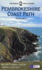
| This walk follows the Pembrokeshire Coast Path, the route of which is detailed in the Ordnance Survey National Trail Guide 7, Pembrokeshire Coast Path (ISBN 1-85410-770-4). Unfortunately the route description is written in reverse to the direction that I am walking, but the 1:25,000 maps in the book are clear and the signs on the ground are very good. Please click on the image to the right to go to the Amazon page for this book. |
 |
Distances
| From | To | Distance (m) | Ascent (ft) | Descent (ft) |
|---|---|---|---|---|
| Castlemartin | Angle | 10.1 | 1608 | 1768 |
| Angle | Pwllcrochan | 5.8 | 741 | 715 |
This makes a total distance of 15.9 miles, with 2349 feet of ascent and 2483 feet of descent.
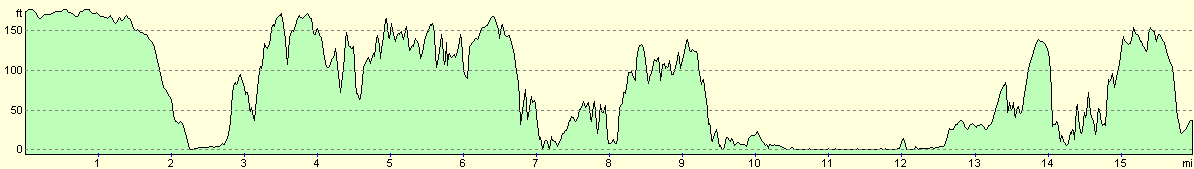
For more information on profiles, ascents and descents, see this page
Accommodation
We spent another night at the campsite at The Old Rectory, OS Field 1066, St Petrox, Pembrokeshire SA71 5EQ. They can be contacted on (01646) 683980. This site cost us seven pounds and twenty-five pence for the night, and was a nice enough site, placed right next door to the beautiful church of St Petrox.
Disclaimer
Please note that I take no responsibility for anything that may happen when following these directions. If you intend to follow this route, then please use the relevant maps and check the route out before you go out. As always when walking, use common sense and you should be fine.
If you find any information on any of these routes that is inaccurate, or you wish to add anything, then please email me.
All images on this site are © of the author. Any reproduction, retransmissions, or republication of all or part of any document found on this site is expressly prohibited, unless the author has explicitly granted its prior written consent to so reproduce, retransmit, or republish the material. All other rights reserved.
Although this site includes links providing convenient direct access to other Internet sites, I do not endorse, approve, certify or make warranties or representations as to the accuracy of the information on these sites.
And finally, enjoy your walking!
This walk was mentioned in the following routes:
| My walk around the coastline of Britain |
| Pembrokeshire Coast Path |
Nearby walks
| # | Title | Walk length (miles) |
|---|---|---|
| 384 | Lydstep to Castlemartin | 20.6 |
| 386 | Pwllcrochan to Milford Haven | 16.9 |
| 387 | Milford Haven to Wooltack | 19.7 |
|
|

|