Walk #323: Dawlish to Torquay
 |
 |
|
General Data
| Date Walked | 11/01/2003 |
| County | Devon |
| Start Location | Dawlish |
| End Location | Torquay |
| Start time | 08.05 |
| End time | 16.14 |
| Distance | 16.0 miles |
| Description | This was another day of two halves; an easy and relatively level first section to Shaldon was followed by a much more strenuous walk over the cliffs to Torquay. |
| Pack | Today I carried my 30-litre Karrimor HotRock rucksack, which was filled with my packed lunch, waterproof leggings, water bottle and a couple of spare shirts, together with the usual assortment of odds and ends. |
| Condition | I am fairly tired after this walk, but I could have walked further if there had been enough daylight. My new boots gave me less trouble than they did yesterday, although they are still far from broken in. My cold is still with me, and it is annoying to struggle up a steep hill breathing heavily only to have to blow my nose once I reach the top! |
| Weather | The weather today was quite cold, and the wind was bitter when I was exposed to it. There was much blue sky about, but clouds were present at times and there no sign of any rain. |
| OS map | Landranger number 192 (Exeter & Sidmouth, Exmouth & Teignmouth) and Landranger number 202 (Torbay & South Dartmoor, Totnes & Salcombe) |
 |
 |
|
 |
 |
|
Map of the walk
Maps courtesy of Google Maps. Route for indicative purposes only, and may have been plotted after the walk. Please let me have comments on what you think of this new format. For a detailed table of timings for this walk, please see the table file.
 |
 |
|
 |
 |
|
Notes
I was out walking for a long time today, and when I finished and worked out how far I had walked I was annoyed that it was not farther. I seem to have spent a long time walking for a relatively little distance completed, an average of about two miles an hour, which is under what I normally achieve. I cannot really explain why this is, and I was very much hoping that I may have got further.
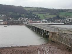
Walking through Teignmouth and Shaldon bought back many memories of school day holidays in the area when I was a child. Sam met me at the Teignmouth side of the Shaldon Bridge and we walked over it together towards Shaldon. The bridge has recently been widened to give pedestrians wider pavements, which rather spoiled the effect; I remember the bridge for being exceedingly narrow and that effect has now been understandably spoilt. When we got into Shaldon we walked the roads along the seafront until we got to the Clipper Cafe, where for tradition's sake we went in and I had a rock cake and strawberry milkshake - my staple diet from the cafe when I as a child. I tried to introduce Sam to the joys of rocks cakes, but I think she is yet to be convinced.
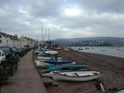
Shaldon and Teignmouth have not really changed much in the ten years since I last got to stroll around them - I have been to Devon since then, but never to walk around the towns - and the only real major difference is that Teignmouth now stretches up Haldon Hill more. The pier was still the same tacky place where we used to occasionally go and put money into the games machines; high speed trains (albeit in different liveries) still run the gauntlet of the waves along the seawall, and the black and white ferry still chugs along between the two places. So much has remained the same, and this was a great relief to me.
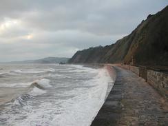
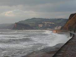
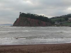
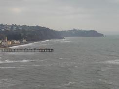
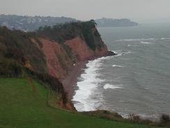
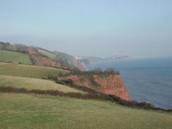
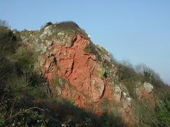
The walk south from Shaldon was quite hard - the initial climb up the red sandstone bluff of The Ness was rewarded by some great views northwards, but this was followed by a series of climbs and descents that I found highly annoying. For much of the time great views were not available, and when they were there were trees in the way that made taking photographs hard. The intervening village of Maidencombe was passed yet not really entered; I only saw the car park, which was slightly annoying as the village is supposed to be lovely.
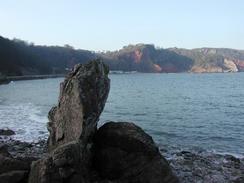
I had arranged to meet Sam in Babbacombe, but when I got there I forgot all about this and continued walking, as I had made Torquay my mental target. As I was walking under cliffs my mobile did not have any reception, and when Sam phoned up she was justifiably annoyed to see that I had walked on. We rearranged the meeting place to be in the centre of Torquay, and I had to hurry slightly as the campsite we were staying at shut its doors at five. Eventually I met up with Sam, who had parked on the road beside the promenade a little way beyond the harbour, and after apologising to her for my mistake we got to the campsite in plenty of time.
Whilst looking at my itinerary tonight I realised that I have made a big mistake. When I was initially planning this walk I was going to be using ferries, and worked out the distance accordingly. When I then decided to walk up the estuaries to the nearest bridges I re-measured the relevant sections, but unfortunately it looks as though I missed out all the rivers on this Ordnance Survey map. There are a few of the rivers that are not important as they are short, but the Dart estuary will involve a long, two-day detour from Kingswear to Totnes and then back to Dartmouth. This will not be on my schedule, and whilst it will increase my overall distance it will also use up most of the days that I was ahead of schedule - days that were hard won. To make matters worse it looks as though the route around the river will mostly be along roads, which will be hard on my feet in the new boots.
 |
 |
|
Directions
| During this walk I followed the South West Coast Path, the route of which is detailed in the Ordnance Survey National Trail Guide 10, Falmouth to Exmouth (ISBN 1-854108-90-5). Unfortunately the route description is written in reverse to the direction that I am walking, but the 1:25,000 maps in the book are clear and the signs on the ground are very good. Also to be recommended is the South West Coast Path Association guidebook (ISBN 0-907055-04-4), which has less concise directions and no maps, but includes accommodation details and grades each section of the walk according to difficulty. They also publish reverse directions, which are suitable for walking in the direction that I walked the route. They have a website at www.swcp.org.uk, which is well worth a visit. | 
|
| 
| |
| |
| |
The exception to the above is the section between Teignmouth and Shaldon, which is done by ferry in the Ordnance Survey guide. A route along roads to the Shaldon Bridge is described in the South West Coast Path Association guidebook, but I just made my own way along the roads; it is relatively easy to do as it is not a great distance.
Distances
| From | To | Distance (m) | Ascent (ft) | Descent (ft) |
|---|---|---|---|---|
| Dawlish Station | Shaldon | 5.5 | 591 | 594 |
| Shaldon | Babbacombe | 5.2 | 1995 | 1873 |
| Babbacombe | Torquay seafront | 5.3 | 1440 | 1545 |
This makes a total distance of 16.0 miles, with 4026 feet of ascent and 4012 feet of descent.
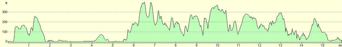
For more information on profiles, ascents and descents, see this page
Accommodation
We stayed at Grange Court, Grange Road, Goodrington, Paignton, Devon TQ4 7JP, telephone 01425 277661 or look at the website at www.hoburne.com. This site cost us eight pounds fifty for the night, and had some reasonable facilities, although it was nothing spectacular.
Disclaimer
Please note that I take no responsibility for anything that may happen when following these directions. If you intend to follow this route, then please use the relevant maps and check the route out before you go out. As always when walking, use common sense and you should be fine.
If you find any information on any of these routes that is inaccurate, or you wish to add anything, then please email me.
All images on this site are © of the author. Any reproduction, retransmissions, or republication of all or part of any document found on this site is expressly prohibited, unless the author has explicitly granted its prior written consent to so reproduce, retransmit, or republish the material. All other rights reserved.
Although this site includes links providing convenient direct access to other Internet sites, I do not endorse, approve, certify or make warranties or representations as to the accuracy of the information on these sites.
And finally, enjoy your walking!
This walk was mentioned in the following routes:
| My walk around the coastline of Britain |
| South West Coast Path |
Nearby walks
| # | Title | Walk length (miles) |
|---|---|---|
| 321 | Sidmouth to Lympstone | 15.3 |
| 322 | Lympstone to Dawlish | 16.0 |
| 324 | Torquay to Coleton Camp | 15.0 |
|
|

|