Walk #321: Sidmouth to Lympstone
 |
 |
|
General Data
| Date Walked | 09/01/2003 |
| County | Devon |
| Start Location | Sidmouth |
| End Location | Lympstone |
| Start time | 08.20 |
| End time | 14.50 |
| Distance | 15.3 miles |
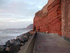
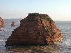
| Description | This was another enjoyable walk, and although the cliffs were not as high and the views as expansive as they were yesterday, they were still very pleasant. |
| Pack | Today I carried my 30-litre Karrimor HotRock rucksack, which was filled with my packed lunch, waterproof leggings, water bottle and a couple of spare shirts, together with the usual assortment of odds and ends. |
| Condition | I feel absolutely fine after this walk, and could easily have walked further if I had not had other things to do. My right elbow and knee, which I slightly injured at the end of yesterday, were both fine today. |
| Weather | It was another cold day today, although I think that it was slightly warmer than it was yesterday. The wind was bitterly cold, and there was no sign of any rain or snow. |
| OS map | Landranger number 192 (Exeter & Sidmouth, Exmouth & Teignmouth) |
 |
 |
|
 |
 |
|
Map of the walk
Maps courtesy of Google Maps. Route for indicative purposes only, and may have been plotted after the walk. Please let me have comments on what you think of this new format. For a detailed table of timings for this walk, please see the table file.
 |
 |
|
Notes
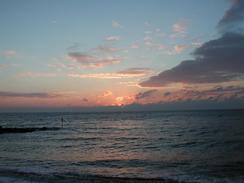
I decided to get an early start to today's walk, as I wanted to get as far north as Exmouth as I could today. I also needed to get into Exeter to do some shopping, so I was concerned about being able to walk a long distance and being able to get to the shops on the train before they shut. Unfortunately this did not really occur, and although I set off early enough to see a beautiful red sky it was not as early as I had hoped.
As I was climbing southwards out of Ladram Bay towards Crab Ledge I saw a man with a large telescope beside the footpath. He called me over and told me that he had a Peregrine Falcon that was sitting on a ledge on the cliffs in his sights. He offered me to view it and when I looked through the scope it was a magnificent sight. The Falcon was sitting on the ledge preening itself, and I found it hard to take my eye off of it. After a few minute it took of from the ledge and went out of the field of view of the scope. I thanked the man and chatted to him for a few minutes before I started the climb uphill once more.
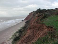
There was a short footpath diversion to the west of Budleigh Salterton that I found highly annoying. The path went uphill along the edge of the cliff before it was temporarily closed due to a cliff fall. The path diverted off to the right downhill back towards the High Street, turned to the left and then after a few hundred yards to the left again to climb uphill onto the cliff path. I do not know why I found this little diversion so annoying, but by the time I reached the path once again I was slightly fed up. A few minutes later something occurred that cheered me up, however. I met his elderly gentleman sitting on a bench, and he told me that a Robin had been perched on his toes and knee a few minutes before. As we chatted the Robin came back, and he hopped around the ground around me, before settling on a branch in the hedge at eye level about six inches away from me. I got a really great view of the Robin, and it seemed to be examining me as closely as I was examining it. Unfortunately I did not have any bread or biscuit to give it, but it seemed happy enough just to hop and fly around us.
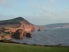
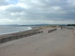
Before I reached Exmouth I passed Orcombe Point, which is the end of the stretch of Heritage Coast that starts at Studland in Dorset. This is marked by a large Geoneedle, which is a large concrete needle with a cross-section through the rocks of the area embedded within it. This was quite a nice idea, and I studied it for a few minutes before moving on and descending down into Exmouth, where I met Sam and she kindly heated up some more spaghetti Bolognese for my lunch.
I finished the walk earlier than I had been intending, as we had to make our way into Exeter so that I could get a new pair of boots that we had ordered. I therefore decided to finish the walk at Lympstone Station, so that we could get the train into the centre of Exeter and not have to bother trying to park in the city. As well as the boots I got a new pair of gaiters, base layer tights (to replace the ones that melted a week ago in a clothes dryer) and a bite valve for my Platypus water container as I had bitten through the old valve. The people at Taunton Leisure in Exeter were kind enough to knock some money off the total as I am doing a charity walk. After this we went to the central library so that I could spend half an hour checking my emails before catching the train back to Lympstone.
This evening Sam and I decided to go to the pub by the station to have a drink to celebrate my one hundredth day of walking on the trip so far. As I was leaving the van a man in faded colourful clothes and with a slightly spaced-out expression on his face came nearby. I wished him a good evening, and he came over and asked me if I was after any hash. I was slightly shocked by this, and after we told him that we did not want any hash he apologised and walked off, going to a car on the other side of the car park as we walked to the pub.
In starting my walk around the Exe I have now started the first of many inland diversions around estuaries in South Devon and Cornwall that are going to very probably prove annoying. The Exe estuary itself should be fairy interesting, but later ones - especially when they come one after another - may well be another matter. Many of these estuaries will require a great deal of road walking, and this may prove to be more annoying than anything else.
Directions
| During this walk I followed the South West Coast Path, the route of which is detailed in the Ordnance Survey National Trail Guide 11, Exmouth to Poole (ISBN 1-854109-88-X). Unfortunately the route description is written in reverse to the direction that I am walking, but the 1:25,000 maps in the book are clear and the signs on the ground are very good. Also to be recommended is the South West Coast Path Association guidebook (ISBN 0-907055-04-4), which has less concise directions and no maps but does include accommodation details and grades each section of the walk according to difficulty. They also publish reverse directions, which are suitable for walking in the direction that I walked the route. They have a website at www.swcp.org.uk, which is well worth a visit. | 
|
| 
| |
| |
| |
The last part of this walk was from Exmouth to Lympstone Station, and this is not covered in the guides. From the end of the SWCP in Exmouth continue along the Esplanade westwards until the road starts to enter the docks. As it does so turn to the right to walk up a road that leads up to the combined Exmouth Bus and Railway Station.
Walk past the station through the car park and then a lorry park, with the railway station to the right. The path follows to the left of the railway line before crossing over it at a pedestrian crossing and joins a road. Turn left down this road and when it curves to the right continue straight on down another footpath. This follows to the right of the railway line before crossing over onto the left-hand side and heading northwards before descending down to meet a road on the southern side of Lympstone. Turn left along this road and follow it as it heads through the village and curves around to the right to the railway station, where this walk ends.
Distances
| From | To | Distance (m) | Ascent (ft) | Descent (ft) |
|---|---|---|---|---|
| Sidmouth | Budleigh Salterton | 6.7 | 1916 | 1919 |
| Budleigh Salterton | Exmouth | 6.1 | 935 | 935 |
| Exmouth | Lympstone Station | 2.5 | 171 | 131 |
This makes a total distance of 15.3 miles, with 3022 feet of ascent and 2985 feet of descent.
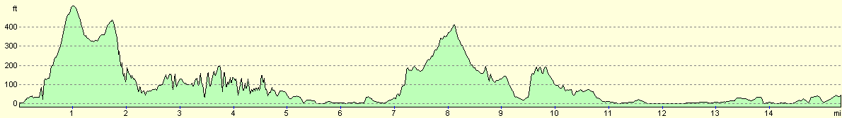
For more information on profiles, ascents and descents, see this page
Accommodation
We parked the van in a large car park near the station in Lympstone, which was handy for the station and was free at this time of the year. There are some public toilets in the car park, but these were locked in the early evening.
Disclaimer
Please note that I take no responsibility for anything that may happen when following these directions. If you intend to follow this route, then please use the relevant maps and check the route out before you go out. As always when walking, use common sense and you should be fine.
If you find any information on any of these routes that is inaccurate, or you wish to add anything, then please email me.
All images on this site are © of the author. Any reproduction, retransmissions, or republication of all or part of any document found on this site is expressly prohibited, unless the author has explicitly granted its prior written consent to so reproduce, retransmit, or republish the material. All other rights reserved.
Although this site includes links providing convenient direct access to other Internet sites, I do not endorse, approve, certify or make warranties or representations as to the accuracy of the information on these sites.
And finally, enjoy your walking!
This walk was mentioned in the following routes:
| My walk around the coastline of Britain |
| South West Coast Path |
Nearby walks
| # | Title | Walk length (miles) |
|---|---|---|
| 320 | Lyme Regis to Sidmouth | 16.0 |
| 322 | Lympstone to Dawlish | 16.0 |
| 323 | Dawlish to Torquay | 16.0 |
|
|

|