Walk #320: Lyme Regis to Sidmouth
 |
 |
|
General Data
| Date Walked | 08/01/2003 |
| County | Dorset, Devon |
| Start Location | Lyme Regis |
| End Location | Sidmouth |
| Start time | 08.40 |
| End time | 16.38 |
| Distance | 16.0 miles |
| Description | This was a lovely, long and strenuous walk westwards along the coast. It is of two halves, with an initial stretch through the fascinating landslips to Seaton followed by lots of ascents snd descents following the coast to Sidmouth. |
| Pack | Today I carried my 30-litre Karrimor HotRock rucksack, which was filled with my packed lunch, waterproof leggings, water bottle and a couple of spare shirts, together with the usual assortment of odds and ends. |
| Condition | I feel relatively okay after this walk, and could easily have walked further if daylight had permitted. I suffered two injuries today; I wrenched my right knee and banged my right elbow, so both are aching this evening in an annoying but non-serious way. |
| Weather | Today was bitterly cold but mostly sunny, and the biting wind was very noticeable on exposed cliff tops. It was mostly dry, except for twenty minutes of light snow at the end of the walk. |
| OS map | Landranger number 193 (Taunton & Lyme Regis, Chard & Bridport) and Landranger number 192 (Exeter & Sidmouth, Exmouth & Teignmouth) |
 |
 |
|
 |
 |
|
Map of the walk
Maps courtesy of Google Maps. Route for indicative purposes only, and may have been plotted after the walk. Please let me have comments on what you think of this new format. For a detailed table of timings for this walk, please see the table file.
 |
 |
|
 |
 |
|
Notes
This was a long and very strenuous walk, and I am pleased that I managed it fairly well with no major problems. Tomorrow I shall reach the Exe estuary, which is the first of the many inland diversions that I shall have to make around estuaries in South Devon. I will also be able to go into Exeter to get a new pair of boots, which will be handy now that I have got onto some steep ground as my old pair have just about had it.
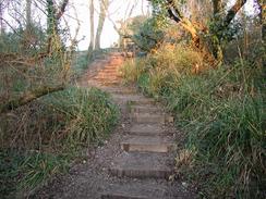
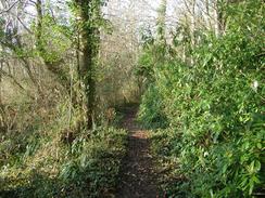
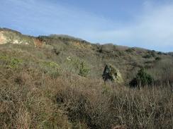
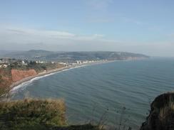
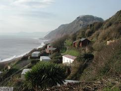
The Dowlands landslips are very impressive. The path through the landslips is wooded, which prevents many views over the sea. The going is quite rough, with lots of little ascents and descents and few level sections to allow yourself a breather. The area is the result of a series of landslips where the thick layers of chalk and greensand slip over a saturated layer of clays. The biggest slip occurred at Christmas 1839, when a massive chasm three quarters of a mile long and sixty metres deep formed, leaving what is now called Goat Island separated from the cliff tops. The whole area is quite fascinating, and there were plenty of signs of more recent minor landslips, with fractured land alongside and across the path in places. The path through the area is mentioned in two books as being treacherous but I found it easy, which could have been because any mud on the ground had frozen, a positive side effect of the cold weather.
When I reached Beer I met Sam in a car park above the town, and she reheated some of the leftover Spaghetti Bolognese that we had for tea last night. This filled me up, and gave me some fuel that helped me tackle the second, harder, part of the day. We had planned to take a photograph of myself having a beer in beer, but I did not want to have to walk back down into town for the photograph. This was a shame, but once I had decided that I was going to walk on to Sidmouth it was obvious that time was going to be at a premium and indeed it was; even without delaying I finally reached Sidmouth at dusk.
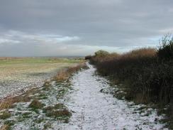
As I was walking up and down the hills during the second half of the day there was a thin layer of snow on the ground in places. What I found strange as that in many places the snow was only on the muddy path; I wonder if the mud is at a slightly lower temperature than the surrounding grass and scrubland, and therefore the snow lasts longer on the mud. I was actually quite glad about this, as it meant that the mud was still frozen and that gave me an easier walk.
I am starting to notice that I am slowly getting fitter as I am faced with an increasing number of steeper hills. The long flat walks along the seawalls in Essex and Kent made me fit for walking on easy, flat terrain, but this does not help much on hills like today. Over the last few days I have been finding it easier climbing the hills, until today I did not have to stop whilst climbing up most of them and I could just slowly plod up them. The problem used to be that I ran out of breath, but today that was not much of a problem and I could just keep on climbing. This is probably only partly to do with increased fitness, and also to do with the fact that I have developed a pace that allows me to keep on climbing without having to stop. I also have been putting some isotonic powder in my drinking water, in an effort to stop myself running out of energy as I did a few days ago at Worth Matravers. This also appears to have worked, and I could have walked further today if daylight had permitted.
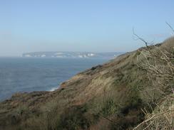
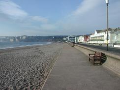
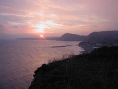
The descent down into Sidmouth was interesting - the path at the top of the hill had been walked on by many people and was exceedingly icy in places. Despite having my walking poles deployed I still slipped - perhaps due to the ever-increasing fragmentation of my boots - and banged my right elbow as I fell onto one of the steps. This meant that I took the rest of the descent slowly, but this was a pleasure as the sun slowly descended ahead of me and the sky took on a beautiful red glow. It also started to snow lightly, which just added to the lovely scene. At the bottom of the hill I noticed that the cliffs were red sandstone, which I remember from many lovely holidays in South Devon when I was a child. This bought home to me the fact that I am now in Devon - the eighteenth county of my walk so far. I love South Devon and the red cliffs bought home all my old memories of joyful family holidays.
Directions
| During this walk I followed the South West Coast Path, the route of which is detailed in the Ordnance Survey National Trail Guide 11, Exmouth to Poole (ISBN 1-854109-88-X). Unfortunately the route description is written in reverse to the direction that I am walking, but the 1:25,000 maps in the book are clear and the signs on the ground are very good. Also to be recommended is the South West Coast Path Association guidebook (ISBN 0-907055-04-4), which has less concise directions and no maps but does include accommodation details and grades each section of the walk according to difficulty. They also publish reverse directions, which are suitable for walking in the direction that I walked the route. They have a website at www.swcp.org.uk, which is well worth a visit. | 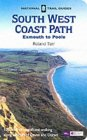
|
| 
| |
| |
| |
Distances
| From | To | Distance (m) | Ascent (ft) | Descent (ft) |
|---|---|---|---|---|
| Lyme Regis | Seaton | 6.7 | 1184 | 1191 |
| Seaton | Sidmouth | 9.3 | 2530 | 2533 |
This makes a total distance of 16.0 miles, with 3714 feet of ascent and 3724 feet of descent.
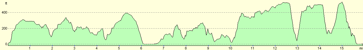
For more information on profiles, ascents and descents, see this page
Accommodation
We parked a little way out of Seaton on a road that sloped downhill towards the town, which led to an interesting night where I kept on rolling down the bed and into Sam during the night.
Disclaimer
Please note that I take no responsibility for anything that may happen when following these directions. If you intend to follow this route, then please use the relevant maps and check the route out before you go out. As always when walking, use common sense and you should be fine.
If you find any information on any of these routes that is inaccurate, or you wish to add anything, then please email me.
All images on this site are © of the author. Any reproduction, retransmissions, or republication of all or part of any document found on this site is expressly prohibited, unless the author has explicitly granted its prior written consent to so reproduce, retransmit, or republish the material. All other rights reserved.
Although this site includes links providing convenient direct access to other Internet sites, I do not endorse, approve, certify or make warranties or representations as to the accuracy of the information on these sites.
And finally, enjoy your walking!
This walk was mentioned in the following routes:
| My walk around the coastline of Britain |
| South West Coast Path |
Nearby walks
| # | Title | Walk length (miles) |
|---|---|---|
| 319 | West Bexington to Lyme Regis | 15.5 |
| 321 | Sidmouth to Lympstone | 15.3 |
| 855 | Rampisham Down to Marshwood | 19.6 |
|
|

|