Walk #283: Island Gardens to Greenwich
 |
 |
|
General Data
| Date Walked | 01/12/2002 |
| County | London |
| Start Location | Island Gardens |
| End Location | Greenwich (Cutty Sark) |
| Start time | 08.10 |
| End time | 14.56 |
| Distance | 16.9 miles |
| Description | This was a relatively short but highly interesting walk through London, which saw me end up only half a mile from where I started. |
| Pack | Today I carried my 30-litre Karrimor HotRock rucksack, which was filled with my packed lunch, waterproof leggings, water bottle and a couple of spare shirts, together with the usual assortment of odds and ends. |
| Condition | I had a few little problems today. The first problem was with my feet, which ached considerably and was probably due to the amount of road walking that I have done today. The other problem was with my left side and shoulder, which at times ached and at other times actually hurt. This looks as though it may be a recurrence of a previous problem that I had earlier in the year, and I may go out tomorrow without a rucksack to see if that eases the problem. |
| Weather | Today's weather was very mixed, with a morning of drizzle and rain being followed by an afternoon of sunshine and cloud with a sometimes fiercely gusting wind. The sun and wind in the afternoon allowed me to dry out, but even then I did not get too warm, particularly as I did not wear a fleece. |
| OS map | Landranger number 177 (East London, Billericay & Gravesend) |
 |
 |
|
 |
 |
|
Map of the walk
Maps courtesy of Google Maps. Route for indicative purposes only, and may have been plotted after the walk. Please let me have comments on what you think of this new format. For a detailed table of timings for this walk, please see the table file.
 |
 |
|
 |
 |
|
Notes
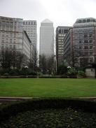
Sam had expressed an interest in coming with me for the first half of today's walk, so we moved Mervan to just outside Island Gardens Station (it is easy to park around that area on a Sunday, but impossible on a weekday), and we set off. The first part of the walk around the Isle of Dogs went very slowly, as I was always diverting off the route to visit places that I used to know when I lived on the island. I had not been around the western side of the island since I left London in 1995, and I was amazed at the way there are many more large apartments scattered about, but there are still many placed that I recognise from the island of old. I must admit that the new buildings are all very large and imposing, but I get the impression that the area is losing some of its character as they are replacing older buildings. When I lived in London I saw a news program where they interviewed an old lady, who I think was in her eighties, who had never, ever been off the Isle of Dogs. It was an amazing thought that someone who lives in the middle of a city like London had never visited anything outside of her immediate vicinity. The news programme took her to Buckingham Palace, which I thought was a nice touch.
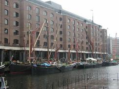
There was a very Brunellian theme to today's walk, with several items of interest to be found on the route. The first is in a way the most impressive, but also the hardest to find. The Isle of Dogs was the place where the Great Eastern, Brunel's last steamship was built. Not only was it the largest ship ever built at the time, it remained the largest ship for another forty years, only being beaten when the Lusitania was built. It was so big that it had to be built broadside to the river instead of end-on, and it covered three individual shipyards. It was a massive undertaking, and if you know where to look you can find the remains of part of the slipway that was used to launch the ship into the river. Later on I passed twice over the East London Railway Line, once on either side of the river, and this is another item of interest about Brunel. The railway line uses Marc and Isambard Brunel's Thames tunnel, which was the first tunnel under water ever built anywhere in the world. On the southern side of the river there is an original pump house, which is now a museum, and although I really wanted to go in to have a look around I could not due to time constraints.
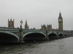
It was either raining or drizzling all morning, which made Sam and myself fairly wet. I had wanted to pose outside the Houses of Parliament at Westminster so that I could have some photos taken, but I decided against this due to the awful weather. Sam left me at Westminster so that she could drive the van over to the southern side of the river, but by the time I had reached halfway across Westminster Bridge the rain had stopped, which I found highly annoying. The rest of the day was far better and the improved weather made for a much more enjoyable walk along the southern side of the river.
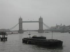
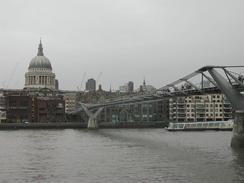
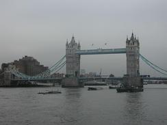
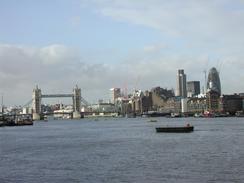
The sheer wide variety of bridges on the Thames is frankly amazing. They start off with the lovely gothic stonework of Tower Bridge, and that is followed by the concrete humdrum of London Bridge. The most interesting bridges have to be the two new ones; the much maligned Millennium bridge and the two pedestrian bridges which are cantilevered off of Hungerford Bridge. I must admit that before I first saw it for myself I disliked the Millennium Bridge intensely, yet seeing it in the flesh changed my mind. It is a very unusual bridge, but also quite elegant, and I find the way that the slender cables are retained at each end to be very interesting. The new Hungerford pedestrian bridges replace a pedestrian walkway across the Hungerford railway bridge. A few years ago this was closed, and these bridges are being built to replace it. The downstream bridge had already been completed and was open to the public, whilst he upstream bridge was nearly completed. The bridges were built by something called incremental launching and this is the first time that this process has been used on a bridge of this size.
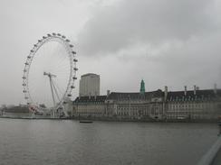
I have always found the architecture of London to be fascinating, from the superb Tower of London and Houses of Parliament to the, to me at least, ugly new council hall. The river has to be the best place to see many of the buildings, and I loved the changing cityscape as I walked along the river.
I normally take about forty or fifty photos a day, but today I took over eighty due to all the things of interest that were on the route. It will take me a long time to write all of these up, but hopefully I shall have some nice photos despite the morning rain.
I now have a long walk eastwards out of London and into Kent to face, getting as far as Margate before having to turn to walk along the south coast. I am quite looking forward to this stretch, and I hope that the weather will be nice, despite the imminent onset of winter.
Directions
The directions for this walk are very simple, as the route follows the Thames Path national trail for it's entirety. This path is extremely well signposted, and even where there are no signposts it is easy to follow the roads beside or paralleling the river. There are lots of items of interest just off the route, so it may well be worth making little diversions to see things.
I chose to cross over the Thames at Westminster Bridge, but any of the bridges before or after Westminster could be used instead; it is a thoroughly arbitrary choice.
Distances
| From | To | Distance (m) | Ascent (ft) | Descent (ft) |
|---|---|---|---|---|
| Island Gardens | Westminster Bridge | 8.3 | 217 | 220 |
| Westminster Bridge | Greenwich | 8.6 | 108 | 105 |
This makes a total distance of 16.9 miles, with 325 feet of ascent and 325 feet of descent.
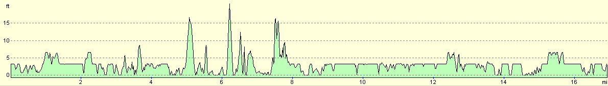
For more information on profiles, ascents and descents, see this page
Accommodation
We parked Mervan at the side of a road just outside Greenwich railway and Docklands Light Railway Station, which had a pub called St Christopher's nearby.
Disclaimer
Please note that I take no responsibility for anything that may happen when following these directions. If you intend to follow this route, then please use the relevant maps and check the route out before you go out. As always when walking, use common sense and you should be fine.
If you find any information on any of these routes that is inaccurate, or you wish to add anything, then please email me.
All images on this site are © of the author. Any reproduction, retransmissions, or republication of all or part of any document found on this site is expressly prohibited, unless the author has explicitly granted its prior written consent to so reproduce, retransmit, or republish the material. All other rights reserved.
Although this site includes links providing convenient direct access to other Internet sites, I do not endorse, approve, certify or make warranties or representations as to the accuracy of the information on these sites.
And finally, enjoy your walking!
This walk was mentioned in the following routes:
| My walk around the coastline of Britain |
Nearby walks
| # | Title | Walk length (miles) |
|---|---|---|
| 50 | Paddington to Mile End | 8.3 |
| 51 | Mile End to Enfield Lock | 12.7 |
| 65 | Alperton to Paddington | 6.4 |
|
|

|