Walk #548: Portknockie to Macduff
 |
 |
|
General Data
| Date Walked | 05/09/2003 |
| County | Grampian |
| Start Location | Portknockie |
| End Location | Macduff |
| Start time | 11.05 |
| End time | 18.23 |
| Distance | 19.0 miles |
| Description | The first half of this walk was absolutely superb, with some superb cliffs to be seen. The second half was not as nice, but it was not a bad walk. |
| Pack | Today I carried my 30-litre Karrimor HotRock rucksack, which was filled with my packed lunch, waterproof leggings, water bottle and a couple of spare shirts, together with the usual assortment of odds and ends. |
| Condition | When I started walking I was feeling quite nauseous, and indeed within half an hour I had been sick. After this I felt much better, although towards the end of the walk my legs became extremely leaden and I found the last few miles quite hard. |
| Weather | The day started off quite nice, with a fair amount of sunshine. As the day went on, however, high cloud developed and the sky became quite hazy. The wind also picked up, and whilst this was annoying at least there was no rain. |
| OS map | Landranger number 29 (Banff & Huntly, Portsoy & Turriff) |
 |
 |
|
 |
 |
|
Map of the walk
Maps courtesy of Google Maps. Route for indicative purposes only, and may have been plotted after the walk. Please let me have comments on what you think of this new format. For a detailed table of timings for this walk, please see the table file.
Notes
It felt very strange to be waking up in a proper bed this morning, and it felt strange to be able to sit up in a bed without hitting my head on the roof. I was extremely tired after the late night last night, although it had been well worth it as Katie and Richard had been great hosts. Sam and I lay in bed for a while before eventually getting up and saying good morning to our hosts.
Katie and Richard were kind enough to allow us to connect a power lead to Mervan, so fairly soon after I got up I fired up the PC and downloaded the photos from my camera onto it. When we are at the RDA group a couple of days ago we took some photos, and they wanted them for some publicity. After this I did some more updates to the website, whilst I was kept amply supplied with coffee and bacon sandwiches by Katie.
As the morning went on I started feeling increasingly rough, and I was not in a hurry to start the walk. Eventually we had to say goodbye to Katie and we set off on the drive to Portknockie and the start of the walk. During the journey the motion of the van, the smell of the water tank (which was full and therefore smelly) and my hangover all combined to make me feel nauseous, and I was very glad when we finally stopped on the road above the pretty harbour in the village.
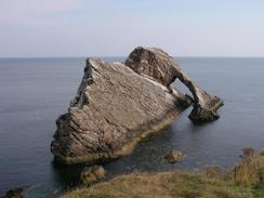
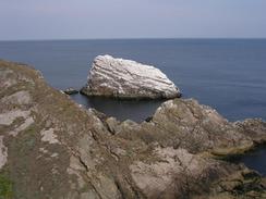
With slightly wobbly legs I set off, and soon left the road and joined the path that headed towards the Bow Fiddle Rock. This is an amazing rock arch, and is one of the best examples of these that I have seen on the trip. Other rocks in the area were white with guano, and the views from near the Bow Fiddle Rock were superb. The path then descended down onto the foreshore and the beach that took me on towards Cullen past Jenny's Well and St Duanes Den, the latter being a large cleft in the cliffs. Unfortunately whilst I was near St Duane's Den I started to feel much worse, and was sick in a rock pool nearby. I quite liked Cullen - the beach to the east of the village was nice, and the harbour was quite attractive as well. The village itself is dominated by a large 8-arch railway viaduct, now sadly disused.
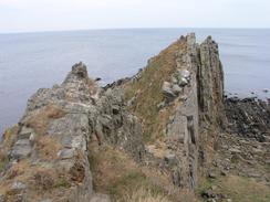
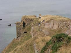
The path from Cullen to Sandend was a truly magnificent walk, especially in the area around Logie Head, where stone steps took me up and down around a headland. The first part of the walk past Logie Head was low on the foreshore, before climbing up onto the clifftop to pass the spectacular remains of Findlater Castle, which is balanced precariously on a little promontory with a steep path leading down to it. I did not go down to visit the ruins as I was running late, but it is something that I would like to come back and visit in the future.
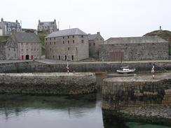
Sandend was a nice village centred on a cute harbour, with black and white buildings surrounding it. I enjoyed the walk through the village, where some kind people gave me some donations, and out onto the beach beside it. Another path took me on to Redhythe Point, and I met Sam just before I descended into Portsoy. I was still feeling quite fragile, but I managed to eat a couple of pieces of cheese on toast before starting the walk once again.
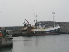
From Portsoy I walked along roads eastwards to Whitehills, where a track took me around Knock Head and Boyndie Bay to reach Banff. By this time my legs were feeling very tired, and as I passed Banff Harbour and looked across Banff Bay to MacDuff I wished that I could be there. I was tempted to get Sam to pick me up, but I knew that there was only two miles left to go and I felt that if I took my time I would get there. The bridge over the River Deveron that links Banff and Macduff was a very nice arched structure, and it looked beautiful as the sun, which was by this time low in the sky, glinted on the bay in front of it. Eventually I reached Mervan, which was parked in a car park near to the aquarium, and collapsed into it. Just before I reached the van I passed Macduff shipyard, where many trawlers were on dry land under repair, looking like large beached leviathans.
We have booked into a campsite in Fraserburgh tomorrow night, and so I will have a long walk, mainly along roads, to get there. The last few days have been absolutely superb, and I can only hope that the rest of this coast will be as nice. I have three weeks walking left now to reach Edinburgh, which is a really strange feeling - I cannot believe that the trip is nearly over.
Directions
This walk starts off on the B9021 road above the harbour in the village of Portknockie. Follow the road as it curves around to the east for a few hundred yards, and when it turns sharply to the right continue straight on down a path that follows the edge of the cliffs towards the spectacular Bow Fiddle Rock. The path continues on the top of the cliffs for a short distance before descending down the cliffs. It then goes over the rocky foreshore past Jennys Well and St Duane's Den before reaching the western end of the beach. Walk southeast along the beach towards Cullen, and then join the seawall and follow it around to the harbour.
From the harbour join a track that runs along the base of the cliffs, and when it ends continue on along a path to Logie Head, where it climbs up and down around the headland on a marvellous set of steps. The path then heads southeastwards to a beach, where it climbs up onto the top of the cliffs before heading eastwards past Findlater Castle, Rathie Point and Garon Point and heading south and descending to meet a road in Sandend.
Follow the road south for a short distance and then drop down onto the beach. Walk east along the beach and then climb up onto the top of the cliffs. A path joins a track for a short distance before turning to the left to head northeastwards to Redhythe Point and southeastwards towards Portsoy. It joins a track before descending down to the old and then the new harbour in the village.
Pass the new harbour and join a short main road that then meets the A98(T). Turn left down the A98(T) and follow it as it passes a hotel and turns sharply to the right. Immediately after the bend turn to the left and descend down a green lane that then climbs up eastwards before meeting the B9139. Follow the B9139 eastwards past Wester Whyntie and Thriepland, and then to the west of Fitmacan take the first road to the left that head north before curving to head eastwards and enter Whitehills.
Follow a road past the harbour and then join a track that passed nock Head before heading southeastwards towards Boynde Bay. When a stream is reached cross it on a footbridge; cross this bridge and on the other side join another track that heads east through a caravan park past a beach. At a car park the track becomes a road, and this can be followed eastwards to a car park by the harbour in Banff. At the harbour turn right head south along roads down the western side of Banff Bay until the large bridge over the River Deveron is reached. Cross the bridge and the turn left to walk northeastwards up the A98(T) for a mile into Macduff; this walk ends at a car park by the aquarium in the town.
Distances
| From | To | Distance (m) | Ascent (ft) | Descent (ft) |
|---|---|---|---|---|
| Portknockie | Cullen | 2.4 | 243 | 289 |
| Cullen | Portsoy | 7.0 | 1047 | 1066 |
| Portsoy | Banff | 7.8 | 732 | 728 |
| Banff | Macduff | 1.8 | 144 | 164 |
This makes a total distance of 19.0 miles, with 2166 feet of ascent and 2247 feet of descent.
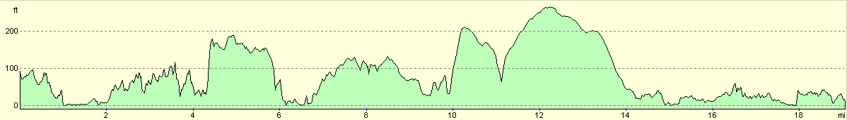
For more information on profiles, ascents and descents, see this page
Accommodation
We parked Mervan in the car park by the aquarium in Macduff, which was a nice enough place to spend the night, with many facilities available nearby.
Disclaimer
Please note that I take no responsibility for anything that may happen when following these directions. If you intend to follow this route, then please use the relevant maps and check the route out before you go out. As always when walking, use common sense and you should be fine.
If you find any information on any of these routes that is inaccurate, or you wish to add anything, then please email me.
All images on this site are © of the author. Any reproduction, retransmissions, or republication of all or part of any document found on this site is expressly prohibited, unless the author has explicitly granted its prior written consent to so reproduce, retransmit, or republish the material. All other rights reserved.
Although this site includes links providing convenient direct access to other Internet sites, I do not endorse, approve, certify or make warranties or representations as to the accuracy of the information on these sites.
And finally, enjoy your walking!
This walk was mentioned in the following routes:
| My walk around the coastline of Britain |
Nearby walks
| # | Title | Walk length (miles) |
|---|---|---|
| 547 | Lossiemouth to Portknockie | 20.8 |
| 549 | Macduff to Rosehearty | 20.5 |
|
|

|