Walk #525: Durness to Hope
 |
 |
|
General Data
| Date Walked | 12/08/2003 |
| County | Highlands |
| Start Location | Durness |
| End Location | Hope |
| Start time | 09.48 |
| End time | 16.27 |
| Distance | 20.1 miles |
| Description | This was a long road plod that was quite disappointing after the stunning walks of the last few days. |
| Pack | I used my new Highlands water hydration pack, which contained a two-litre water bottle, some spare batteries and a couple of chocolate bars. |
| Condition | I am mostly fine after this walk, and the only problem that I have is that a couple of the toenails on my left foot ache a little, which is hardly a major problem. |
| Weather | It was not as warm today as it had been for the last few days, and it was mostly cloudy all day. There were some periods of sunshine, but these were few and far between. Some of the clouds were quite dark, but fortunately none of these led to rain. |
| OS map | Landranger number 9 (Cape Wrath, Durness & Scourie) |
 |
 |
|
 |
 |
|
Map of the walk
Maps courtesy of Google Maps. Route for indicative purposes only, and may have been plotted after the walk. Please let me have comments on what you think of this new format. For a detailed table of timings for this walk, please see the table file.
Notes
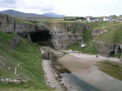
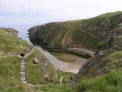
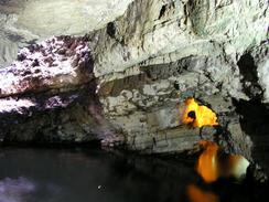
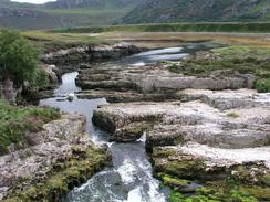
As expected I took yesterday off, mainly so that I could get a website update done - over the last four days I had not done as much work as I had intended to, and it was nice to have all day to do it in. It also gave us an opportunity to explore the area a little more, and this included a trip around Smoo Cave, a mile to the east of the village. This cave is very impressive, and is a sea cave that was widened by glacial melt water. The sea no longer reaches the mouth of the cave, but it does flow through a narrow 800-metre long channel towards the cave mouth. There are a couple of blowholes visible in the roof of the caves (for there are other chambers further underground than the main one), and there is a bridge over one of these on the top of the cliffs. We paid three pounds each for a twenty minute tour of the cave, most of which seemed to be taken up with getting into the inflatable boat that is need to cross one of the chambers. The visit was really superb, and made a great change to walking.
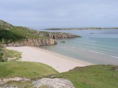
Sam is of the opinion, and I really cannot disagree with her, that the beaches in this northwestern corner of Scotland are the best that she has seen anywhere in the world, and considering she is Australian that is indeed a big complement. She had planned to spend the afternoon walking around the area some more, but at Smoo Cave she had a little slip and injured her left ankle a little - fortunately it is not too bad, but it was aching enough to stop her from going out again later in the afternoon. We therefore had quite a lazy afternoon, which certainly helped me to recharge my batteries.
I woke up very late this morning, at about half past seven, and even when I did wake up I found myself prevaricating. I had got the website ready for writing to CD last night, and so I did the rest of the job this morning. For four years I have been doing a sectional Land's End to John O'Groats walk, and the only section that I had remaining to be done was the part along the north coast of Scotland from Cape Wrath to John O'Groats. I am doing this leg as part of this trip around the coast, and so the LE-jog web pages are being updated for the first time in a year. As part of this, I would like the web pages to have an SVG map of the LE-JOG walk, and I started doing some work on the scripts to allow this. Unfortunately I did not have time to complete the work, but I shall have to finish it next time that we have mains power. This delayed me even more, and so it was far later than I intended before I set off.
Eventually I did set off, and my first port of call was Smoo Cave. When we had visited the cave yesterday my camera had run out of batteries and I had not taken any spares, so I wanted to have a quick walk around so that I could take some photos for my collection. The tide was high when I arrived, which made the channel leading to the cave even more spectacular, and I took loads of photographs - I can only hope that they turn out okay, as the interior of the cave was rather dark.
The weather was good as I started the long plod around Loch Eriboll, and I enjoyed the walk despite the scenery was nowhere near as good or dramatic as it had been over the previous few days walking. Just north of Laid I looked out for a souterrain, a first century AD underground passage, which is marked by two cairns by the roadside. The entrance to the passage is only a few yards from the road, and when I went to investigate it I found a low roof over some stone steps leading underground. It was at this stage that I wished that I had my head torch with me - I would not have minded going down into it to have a look at it, despite the low roof that would have meant that I would have to almost bend double to get in! The entrance to the souterrain was covered with midges, and so I did not stay too long as they were starting to bite me.
I met Sam for lunch at a little lay-by on the southwestern side of Loch Eriboll, and she made me some lovely soup - just what I needed to give me a little energy. For some time I have fancied the idea of having a hydration pack that I can use to hold water when I want to travel light without my rucksack in good weather, but the platypus hydration packs are too expensive for me to justify (I use platypus hydration kit as they are excellent). In the shop in Durness yesterday Sam found a hydration pack by a company called Highlander, and as this was far cheaper than the Platypus version I bought one. Today was my first day of using it and I must say that I am quite impressed - even with two litres of water in it I do not notice the load on my shoulders, and I found it very comfortable. It has a pocket in which I can put spare batteries, and some mesh that fits four energy bars, so it has nearly all the storage I need - the only exception being my sandwiches, which is not that important considering Sam meets me most days
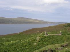
I was disappointed with the views over Loch Eriboll - I had expected the views to be quite attractive, especially with the Foinaven range of mountains a short distance to the west and Ben Hope (the most northerly Munro) to the east, but the views never turned out to be very good - perhaps I have just been spoiled by the scenery over the last few days. In the Second World War Loch Eriboll was used to form convoys, and the sailors called it 'Loch 'Orrible', and whilst this is unfair I can easily see why sailors would not have liked spending time in a place with so few facilities.
The rest of the walk went well even though it was boring, and I met Sam in Mervan in a lay-by just before the descent into the hamlet of Hope. Perversely the lay-by has perhaps the best views of all day, south along Loch Hope to Ben Hope. I wanted to end the walk here so that if the weather is good tomorrow I shall walk around the little peninsular to Whiten Head; if the weather is bad then I will probably avoid it and just walk along the road straight to Tongue. I have also noticed something interesting about Loch Eriboll - it is my last loch! Seemingly for months I have been encountering a new loch virtually every day, and this has now come to an end. he next inlet is the Kyle of Tongue, and after this comes a series of bays all the way along the north coast. This makes today much more of a red-letter day than I had thought it would be, and whilst having to walk around all those lochs was annoying, I will miss them all the same.
Directions
This walk starts off at the campsite in the village of Durness, and the directions are very simple as it follows the A838 road. Leave the campsite and turn left to join the A838 road. Follow this roads as it heads eastwards past Smoo Cave towards Rispond, where it turns to the right to head southwards along the western shore of Loch Eriboll. Follow the road as it skirts the southern end of the loch and starts to head northeastwards along the eastern shore of the loch. Before the mouth of the loch is reached the road turns to the right to head eastwards, and this walk ends about a mile further eastwards in a lay-by on the right overlooking Loch Hope, just before the road descends sharply down into Hope.
Distances
| From | To | Distance (m) | Ascent (ft) | Descent (ft) |
|---|---|---|---|---|
| Durness | Head of Loch Eriboll | 12.4 | 955 | 988 |
| Head of Loch Eriboll | Hope | 7.7 | 971 | 879 |
This makes a total distance of 20.1 miles, with 1926 feet of ascent and 1867 feet of descent.
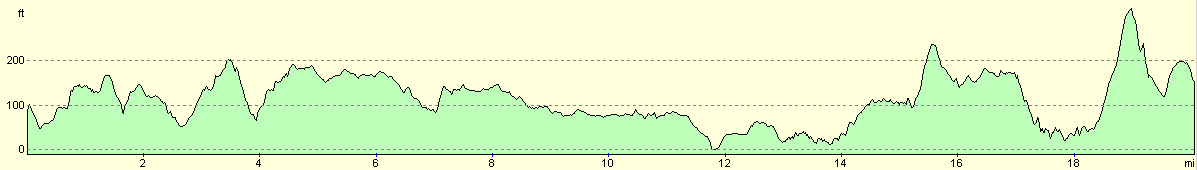
For more information on profiles, ascents and descents, see this page
Accommodation
We parked Mervan in a little lay-by beside the A838 road just uphill to the east from the village of Hope at grid reference NC 46727 59745. This was a reasonable place to spend the night, with some great views south over Loch Hope towards Ben Hope. There were no facilities nearby, although fortunately we did not need any.
Disclaimer
Please note that I take no responsibility for anything that may happen when following these directions. If you intend to follow this route, then please use the relevant maps and check the route out before you go out. As always when walking, use common sense and you should be fine.
If you find any information on any of these routes that is inaccurate, or you wish to add anything, then please email me.
All images on this site are © of the author. Any reproduction, retransmissions, or republication of all or part of any document found on this site is expressly prohibited, unless the author has explicitly granted its prior written consent to so reproduce, retransmit, or republish the material. All other rights reserved.
Although this site includes links providing convenient direct access to other Internet sites, I do not endorse, approve, certify or make warranties or representations as to the accuracy of the information on these sites.
And finally, enjoy your walking!
This walk was mentioned in the following routes:
| My walk around the coastline of Britain |
| My sectional Land's End to John O'Groats walk |
Nearby walks
| # | Title | Walk length (miles) |
|---|---|---|
| 524 | Kearvaig to Durness | 23.8 |
|
|

|