Walk #441: Cargo to Gretna
 |
 |
|
General Data
| Date Walked | 13/05/2003 |
| County | Cumbria |
| Start Location | Cargo |
| End Location | Gretna |
| Start time | 11.30 |
| End time | 18.30 |
| Distance | 17.6 miles |
| Description | This was a lovely walk with which to complete my walk around England. It was mainly a walk to negotiate the River Eden and Esk, to reach the Scottish border. |
| Pack | Today I carried my 30-litre Karrimor HotRock rucksack, which was filled with my packed lunch, waterproof leggings, water bottle and a couple of spare shirts, together with the usual assortment of odds and ends. |
| Condition | The biggest problem that I had today was with my left ankle, which was aching considerably by the time that I reached Longtown. Fortunately this improved once I had put trainers on for the last few miles, and the problems ceased. Aside from this I was fine, and I had no other significant problems. |
| Weather | Today was another day of sunshine and showers, some of which were quite heavy. I even had a few minutes of hail, which is the first hail that I have had for some time. Fortunately most of the day was sunny, which meant that I soon dried off after the rain. |
| OS map | Landranger number 85 (Carlisle & Solway Firth, Gretna Green) |
 |
 |
|
 |
 |
|
Map of the walk
Maps courtesy of Google Maps. Route for indicative purposes only, and may have been plotted after the walk. Please let me have comments on what you think of this new format. For a detailed table of timings for this walk, please see the table file.
 |
 |
|
Notes
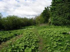
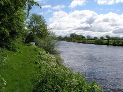
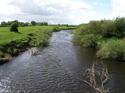
I had a very late start today, indeed I believe that it was the latest start of the walk so far. This was mainly due to little odd jobs that I had to get done around Mervan and on the computer, and it also gave me a chance to spend some time with Sam. It is very nice to be able to set off as late as I did, and still get a decent distance walked with lots of daylight left. The first stretch of walk along the River Eden was quite nice, although the path was rather overgrown in places, and I enjoyed the views over the river as I walked along towards Rockcliffe.
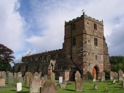
When I reached Rockcliffe I diverted slightly to climb up to see the church. This has a lovely stone steeple, and as the door was open I entered so that I could have a look around and give a prayer of thanks for having walked England and Wales. There was a lady in the church who was preparing flowers for a wedding tomorrow, and I ended up chatting to her for nearly half an hour. The interior of the church was smart but not particularly interesting, which was a shame. Apparently in the nineteenth century lightning hit the steeple and sent it crashing through the church roof, which could explain why so little in the church looks massively old.
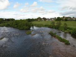
I decided to be slightly cheeky, and instead of walking along the footpath back past Castletown House I decided to walk along to the Esk Boathouse along the flood bank, which is not a right of way. When I reached the boathouse there were some farmers working there, and I cheekily pleaded getting lost as my reason for being on their land, which they accepted and we had a quick chat. This evening I found a very old amp of the area, and it shows a low-tide ford over the River Esk near Sarkfoot Point, which can be reached from the track across Rockcliffe Marsh. I can only assume that the ford is no longer walkable, but it would be interesting to see what state it is in.
The church at Arthuret (just to the south of Longtown) was my last church in England, and it is a lovely church, made of a red sandstone that seems to glow in the sun. I wanted to go into the church as it was the last church in England and I wanted to pray, but unfortunately it was locked up. I walked around the outside of the church, which is a lovely construction, and I enjoyed looking up at the architectural details. Just outside the churchyard there is a holy well, and I also went down to visit this (which was not that pleasing, especially as there was a coke bottle floating in it), before making my way to Longtown.
I met Sam in the centre of Longtown, and I was very glad of the opportunity to take the weight off my feet. Sam has been busy organising things ready for me to cross the border tomorrow, and she updated me with the latest information. I was totally knackered by this stage, and I was in two minds about whether or not I should continue on. If I stopped at Longtown it would have been a short day - fourteen miles - whilst if I continued on towards Gretna it would become a much more reasonable seventeen miles. I used the opportunity to change into my trainers to see if that would reduce the strain on my left ankle during the road walk, and then set off, into skies darkened by the heavy clouds overhead. The walk was along the A6071 road, and passes a military munitions storage facility that unsurprisingly is not marked on the Ordnance Survey map.
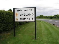
Sam had parked Mervan in the car park of the Gretna Chase Hotel, which I reached with great relief. Immediately outside the hotel on the road there is a sign stating welcome to England and Cumbria, and a few yards away on the other side of the bridge over the River Sark there is a sign stating welcome to Scotland. I therefore decided that I was spending the night in a sort of no-man's land, because (at least according to the signs) I was neither in Scotland or England. In reality the border runs along the middle of the River Sark, and so I shall have to walk for a few yards first thing in the morning to enter Scotland, the last country on my trip.
For a few days now we have been getting Scottish television, which I find amusing as we have not yet left England. Tonight we are only a few yards away from Scotland, but I can imagine that the existence of an electromagnetic barrier running down the centre of the River Sark that kept English radio signals in England, and Scottish ones in Scotland. A very silly thing to imagine, and very possibly impossible to achieve, but an amusing thing to think about nonetheless.
Directions
This road starts off by the pub in the village of Cargo. Turn left to walk down the road, and by a farm turn left to walk down a track, and when this track curves to the right after a short distance continue straight on down a footpath that heads to the river bank of the River Eden. Turn right to walk along the footpath that follows the riverbank all the way into the village of Rockcliffe.
When the path ends at a road near the church in Rockcliffe turn left and follow this road westwards. When the road curves sharply to the right continue on along a footpath that descends down to the foreshore, which it then follows westwards. After a mile the path curves around to head back towards Rockcliffe; I however, climbed onto the flood bank and followed this northwards for a couple of kilometres to the Esk Boathouse. This section of flood bank is not a public right of way, but it was quite a handy section to walk as it saves me having to divert back to Rockcliffe.
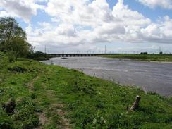
At Esk Boathouse turn right to walk south along the road, and then take the first road off to the left. After a few hundred yards this road turns sharply to the right near Halltown, and when it does this continue straight on along a footpath that heads northeastwards across some boggy ground. This path meets a track, which it follows as far as the farm at Garriestown. Walk through the farm and follow the road out of it for a few yards, before taking a footpath off to the left that leads to the railway line. Cross the railway line using the footbridge and continue on along the footpath towards the inn at Metal Bridge, beside the A74(T).
The footpath passes under the bridge using a track, and on the other side heads off along a track. This track ends, and a footpath continues on to meet the farm at Lynefoot. Turn right and head southwards along a road from Lynefoot until it ends at a T-junction, and then turn left and follow the road around past Justicetown and Firbank. Just before the road meets the A7(T) a cycle path heads off to the left, following the trackbed of an old railway line. Turn left and follow this cycle path as it crosses the River Lyne and ends at a road.
Turn left and follow this road as it heads westwards for a short distance, before turning to head northwards past The Fauld until it reaches Arthuret Church. Turn left and walk through the churchyard, and on the other side follow a footpath that heads past a well and then head north along a footpath that ends at a road in Longtown. Turn to the right and head eastwards for a short distance until the A7(T) is met. Turn to the left and follow the A7(T) through the village and over the bridge over the River Esk. Continue along this road, and at the junction with the A6071 continue straight on westwards along the A6071 for a few miles until the bridge over the A74(M) is reached. Continue straight on as the road curves to the right and becomes the B7076. This road ends at the Gretna Chase Hotel, a couple of hundred yards along this road and immediately before the bridge over the River Sark.
For more details of the Cumbria Coastal Way, see the excellent little book, The Cumbria Coastal Way: A Walker's Guide", by Ian and Krysia Brodie, ISBN 187355110X. This book is a lovely and detailed description of the walk, and unfortunately I did not manage to get a copy until after I finished the walk, for it would have been quite handy.
Notes: September 2019. The long walk east from the A74 at Metal Bridge to Longtown and back to Gretna can now be avoided, thanks to the work to turn the A74(T) into a motorway, which was completed in 2008 to fill the 'Cumberland Gap' and complete the motorway between Birmingham and Glasgow. When you reach the Metal Bridge Inn (which has apparently recently reopened), turn right along its access road and follow it as it swings to the left to end at a new road that runs alongside the M6. It soon crosses the River Esk on a bridge, and continues to parallel the motorway on the right. After two miles it reaches the B7076 on the southern outskirts of Gretna, saving about seven miles off the route mentioned, and making this day just ten miles long.
Distances
| From | To | Distance (m) | Ascent (ft) | Descent (ft) |
|---|---|---|---|---|
| Cargo | Rockcliffe | 3.4 | 115 | 128 |
| Rockcliffe | Longtown | 10.4 | 328 | 315 |
| Longtown | Gretna | 3.8 | 66 | 75 |
This makes a total distance of 17.6 miles, with 509 feet of ascent and 518 feet of descent.
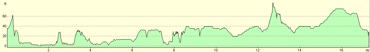
For more information on profiles, ascents and descents, see this page
Accommodation
We spent the night in the car park of the Gretna Chase Hotel, which is just on the English side of the border, off the B7076 road. They were kind enough to let us stay in the car park, and we had a couple of drinks in the hotel tonight, which in the past has won awards for its gardens.
Disclaimer
Please note that I take no responsibility for anything that may happen when following these directions. If you intend to follow this route, then please use the relevant maps and check the route out before you go out. As always when walking, use common sense and you should be fine.
If you find any information on any of these routes that is inaccurate, or you wish to add anything, then please email me.
All images on this site are © of the author. Any reproduction, retransmissions, or republication of all or part of any document found on this site is expressly prohibited, unless the author has explicitly granted its prior written consent to so reproduce, retransmit, or republish the material. All other rights reserved.
Although this site includes links providing convenient direct access to other Internet sites, I do not endorse, approve, certify or make warranties or representations as to the accuracy of the information on these sites.
And finally, enjoy your walking!
This walk was mentioned in the following routes:
| My walk around the coastline of Britain |
Nearby walks
| # | Title | Walk length (miles) |
|---|---|---|
| 439 | Angerton to Burgh by Sands | 17.3 |
| 440 | Burgh by Sands to Cargo via Carlisle | 17.3 |
| 442 | Gretna to Powfoot | 17.9 |
|
|

|