Walk #350: St Ives to Portreath
 |
 |
|
General Data
| Date Walked | 08/02/2003 |
| County | Cornwall |
| Start Location | St Ives |
| End Location | Portreath |
| Start time | 08.50 |
| End time | 16.01 |
| Distance | 17.7 miles |
| Description | This was a highly enjoyable walk following the South West Coast Path. The second half was definitely more enjoyable than the first half, with some nice and not too strenuous beach and cliff top walking. |
| Pack | Today I carried my 30-litre Karrimor HotRock rucksack, which was filled with my packed lunch, waterproof leggings, water bottle and a couple of spare shirts, together with the usual assortment of odds and ends. |
| Condition | The biggest problem on this walk was with the underside of my feet, which were quite sore by the end of the day. Once I had finished I discovered that the reason for this was that I was using an old pair of 1000-mile socks, and I had used some Compeed plasters in this pair on a previous occasion. The plaster had stick to the inside lining of the sock, and had formed a little mound that had been rubbing against the underside of my feet, making them sore. I shall have to retire these socks now, as it is not nice getting sore feet. Aside from this I had no other problems that are worth reporting. |
| Weather | Today started off with a light drizzle shower as I walked from St Ives to Carbis Bay, but this soon cleared up and left me with a day that was quite mild and occasionally sunny. It never really threatened to rain again, and this made for a generally nice days walk. |
| OS map | Landranger number 203 (Land's End & Isles of Scilly, St Ives & Lizard Point) |
 |
 |
|
 |
 |
|
Map of the walk
Maps courtesy of Google Maps. Route for indicative purposes only, and may have been plotted after the walk. Please let me have comments on what you think of this new format. For a detailed table of timings for this walk, please see the table file.
 |
 |
|
Notes
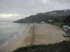
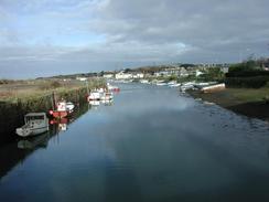
After the hard walk of yesterday I was very much looking forward to an easier walk today, and thankfully that was exactly what I got. I had no hard or difficult sections of path to traverse today, and this made for a very enjoyable little ramble over which I took my time. The first part of the walk from St Ives to Hayle was fairly boring and not massively nice, as it involved a great deal of road walking around Lelant and Hayle. The early part around Carbis Bay did have some nice views northwards over the Porth Kidney Sands however, although I did not think that these were worth the ascents needed to get up the cliffs.
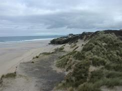
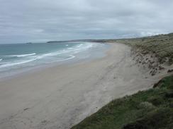
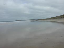
The second part of the walk northwards from Hayle was much better, however. For one thing it included my first significantly long walk along a beach or seemingly ages - this being the stretch of beach from Hayle to Gwithian. This beach was mostly very firm to walk on, and as the tide was far enough out I chose to walk along the beach rather than the dunes behind the beach, which would have involved much ascent and descent over sand that was at times loose. The dunes themselves are very impressive, and I enjoyed exploring them at their southern end before I dropped down onto the beach. As I got to the northern end of the beach the cliffs to my right started to be consisted of rock and not sand. This soon made me realise that the last way up them was a far way back, so when I came across a big and impassable pool of water between two rocky areas under the cliffs (the cliffs becoming far more ragged at the northern end of the beach) I decided to scale them. I quickly found a place where this would be relatively easy and made my way up to the top of the cliffs, emerging right next to a lifeguard hut. On the other side of the hut there was an access ramp down to the beach - if I had only walked through the pool I would have been able to get up to the cliff top using this, which would have been far safer but would have involved getting my boots wet wading through the pool.
In Gwithian I met Sam for a quick drink in a pub that was only a short distance from the path. The pub was quite nice, and was very unusual in the fact that the roof beams had many - probably in the order of hundreds - of mugs hanging from them. Apparently the previous landlord started this collection, and the current owners had reordered and extended it. We had a very nice chat to the landlady about some of the local characters in the area whist we had a drink. It is nice now that there are enough hours of daylight to allow me to take a short time off at lunchtime and relax and still do a reasonably long walk, and fortunately this situation will only get better as spring starts.
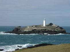
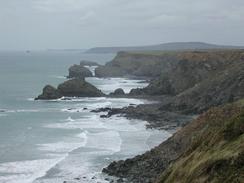
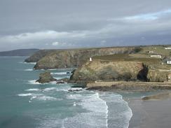
The last part of the walk was along cliff top paths northwards from Gwithian. The initial steady and unchallenging climb took me up to Godrevy Point, with the lighthouse next to it on Godrevy Island. This lighthouse was the inspiration for Virginia Woolf's 'To the lighthouse', and it made for quite a spectacular setting - I was able to see the lighthouse for a long time before I reached St Ives yesterday. The rest of the walk along the top of the cliffs was very straight forward, and except for a couple of little valleys was flat. The path was in quite a god condition to walk along, and this was probably due to the fact that the B3301 road runs close by for a long way, and there are lots of little car parks and paths linking them with the coastal path.
Tomorrow I have what promises to be a very nice walk ahaead of me if the weather is nice. Perranporth is only about twelve or thirteen miles away, so I may well extend the walk by walking northwards as far as Holywell along the Perran Beach. This means that I shall be in a very good place to pass through Newquay the day after, and reach Padstow soon after that.
Directions
| During this walk I followed the South West Coast Path, the route of which is detailed in the Ordnance Survey National Trail Guide 9, Padstow to Falmouth (ISBN 1-854108-50-6). Unfortunately the route description is written in reverse to the direction that I am walking, but the 1:25,000 maps in the book are clear and the signs on the ground are very good. Also to be recommended is the South West Coast Path Association guidebook (ISBN 0-907055-04-4), which has less concise directions and no maps, but includes accommodation details and grades each section of the walk according to difficulty. They also publish reverse directions, which are suitable for walking in the direction that I walked the route. They have a website at www.swcp.org.uk, which is well worth a visit. | 
|
| 
| |
| |
| |
Distances
| From | To | Distance (m) | Ascent (ft) | Descent (ft) |
|---|---|---|---|---|
| St Ives lifeboat station | Hayle | 5.4 | 804 | 794 |
| Hayle | Gwithian | 4.1 | 276 | 230 |
| Gwithian | Portreath | 8.2 | 1539 | 1555 |
This makes a total distance of 17.7 miles, with 2619 feet of ascent and 2579 feet of descent.
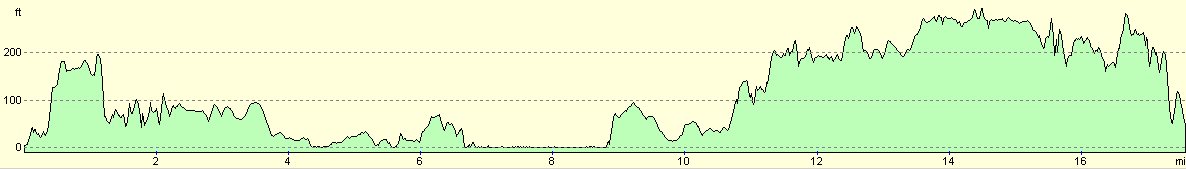
For more information on profiles, ascents and descents, see this page
Accommodation
We stayed at the campsite attached to the Radnor Golf and Ski Centre, Radnor Road, Redruth TR16 5EL. They can be contacted on (01209) 211059. This site cost us seven pounds for the night and included the best showers that we have had for some time - fully adjustable in both posture and temperature. All pitches were hard standing as well, which makes a big difference.
Disclaimer
Please note that I take no responsibility for anything that may happen when following these directions. If you intend to follow this route, then please use the relevant maps and check the route out before you go out. As always when walking, use common sense and you should be fine.
If you find any information on any of these routes that is inaccurate, or you wish to add anything, then please email me.
All images on this site are © of the author. Any reproduction, retransmissions, or republication of all or part of any document found on this site is expressly prohibited, unless the author has explicitly granted its prior written consent to so reproduce, retransmit, or republish the material. All other rights reserved.
Although this site includes links providing convenient direct access to other Internet sites, I do not endorse, approve, certify or make warranties or representations as to the accuracy of the information on these sites.
And finally, enjoy your walking!
This walk was mentioned in the following routes:
| My walk around the coastline of Britain |
| South West Coast Path |
Nearby walks
| # | Title | Walk length (miles) |
|---|---|---|
| 77 | Land's End to Zennor | 16.5 |
| 78 | Zennor to Gwithian | 14.4 |
| 79 | Gwithian to Perranporth | 16.5 |
|
|

|