Walk #57: Waterbeach to Newmarket Road, Cambridge
General Data
| Date Walked | 10/12/1999 |
| County | Cambridgeshire |
| Start Location | Waterbeach |
| End Location | Newmarket road, Cambridge |
| Start time | 06.30 |
| End time | 08.10 |
| Distance | 5.4 miles |
| Description | This walk followed the western bank of the Cam as far as Baits Bite Lock, Milton, and then crossed over to the eastern bank and walked into Fen Ditton and hence into work. |
| Pack | Today I carried full Pennine Way kit. |
| Weather | The weather this morning was very nice. There were not many clouds in the sky, and when the sun finally rose it was sunny. It was not too cold either, despite the early hour. |
| Condition | I feel absolutely fine after this walk. I used my new Salomon boots on this walk just so that I could try them on a short walk before using them on a longer one. |
| OS map | Landranger number 154 (Cambridge & Newmarket, Saffron Walden) |
Map of the walk
Maps courtesy of Google Maps. Route for indicative purposes only, and may have been plotted after the walk. Please let me have comments on what you think of this new format. For a detailed table of timings for this walk, please see the table file.
Notes
This was a lovely walk, starting off in the dark and then following the river as the sun slowly rose. Despite the fact that it was early December it was not very cold - new thermal sports long john's that I bought this week really kept my legs warm (I can't believe that I am actually extolling the virtues of thermal long john's - how sad can a guy get?). This was an equipment test walk - I wanted to check how well my new Salomon boots performed (answer: well) and how warm my equipment kept me (answer: warm). However, it was a mild day and not as cold as I was expecting, so I guess that I will have to do another walk to make any conclusions ;*)
This turned out to be quite a short walk, although despite this it was worth doing, as a short walk like this is quite nice from time to time.
Directions
(Note that these directions are from my flat in Bannold Road, Waterbeach; to walk it from the centre of the village remove 3/4 of a mile, and from the railway station 3/4 of a mile).
Walk along Bannold Road towards Bottisham Lock and the River. Once the river has been reached, cross over by the bridge and follow the eastern bank southwards past a marina until you reach a road bridge at Clayhithe.
Cross over the road and bridge, and follow the path on the western bank of the river southwards. Follow the river for a couple of miles. This is a very nice section of river and a joy to walk. Eventually you reach Bait Bite Lock, just south of a path leading to the village of Milton.
Cross over the bridge over the lock and follow the path past a house and then southwards through a wooded area. This wood then finished, and you cross a field and a stile before coming to a bridge under the A14. Pass under this, trying to ignore the noise of the traffic and cross a stile before angling across a field and onto a road.
Follow this road through a residential area as it twists and turns. At a junction near a cross, take a path straight ahead which leads into Fen Ditton estate.
When you reach a road on the estate turn left and follow the road around. When you reach a crossroads, turn left and follow the road until you reach a main road opposite a parade of shops. Turn right onto this road and follow it for a few hundred yards until you reach Newmarket Road.
Distances
| From | To | Distance (m) | Ascent (ft) | Descent (ft) |
|---|---|---|---|---|
| Waterbeach | Newmarket road, Cambridge | 5.4 | 49 | 20 |
This makes a total distance of 5.4 miles, with 49 feet of ascent and 20 feet of descent.
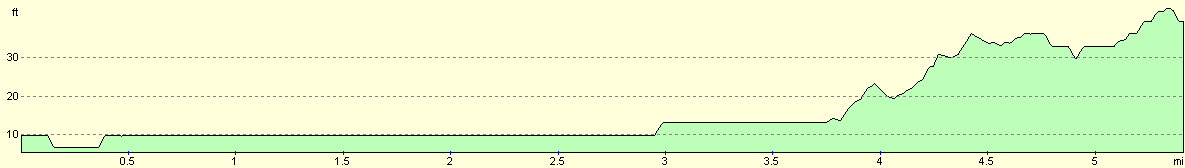
For more information on profiles, ascents and descents, see this page
Disclaimer
Please note that I take no responsibility for anything that may happen when following these directions. If you intend to follow this route, then please use the relevant maps and check the route out before you go out. As always when walking, use common sense and you should be fine.
If you find any information on any of these routes that is inaccurate, or you wish to add anything, then please email me.
All images on this site are © of the author. Any reproduction, retransmissions, or republication of all or part of any document found on this site is expressly prohibited, unless the author has explicitly granted its prior written consent to so reproduce, retransmit, or republish the material. All other rights reserved.
Although this site includes links providing convenient direct access to other Internet sites, I do not endorse, approve, certify or make warranties or representations as to the accuracy of the information on these sites.
And finally, enjoy your walking!
Nearby walks
| # | Title | Walk length (miles) |
|---|---|---|
| 46 | Bellingham to Byrness | 14.7 |
| 48 | 18-mile bothy to Kirk Yetholm | 7.2 |
|
|

|