Walk #980: Ouse Valley Way: A circular wak between Harrold and Olney
 |
 |
|
General Data
| Date Walked | 26/01/2018 |
| County | Bedfordshire, Buckinghamshire |
| Start Location | Harrold country park |
| End Location | Harrold country park |
| Start time | 07.51 |
| End time | 13.22 |
| Distance | 15.7 miles |
| Description | This was a rather muddy circular walk, taking in parts of two trails: the Three Shires Way and the Ouse Valley Way. |
| Pack | Today I carried my 30-litre Karrimor rucksack, filled with water, my waterproofs, a book and other odds and ends. |
| Condition | I am fairly tired after this walk, and my legs feel very heavy as a result of all the mud I had to carry around on my boots. |
| Weather | Today was a fairly mild day, with sunny periods intermised with some periods of cloud. |
| OS map | Landranger number 153 (Bedford & Huntingdon, St Neots & Biggleswade) and Landranger number 152 (Northampton & Milton Keynes) |
 |
 |
|
Map of the walk
Maps courtesy of Google Maps. Route for indicative purposes only, and may have been plotted after the walk. Please let me have comments on what you think of this new format. For a detailed table of timings for this walk, please see the table file.
 |
 |
|
Notes
I wanted my next walk to be another stretch of the Ouse Valley Way, and the obvious choice would be a 21-mile leg from Newport Pagnall to Harrold. However there were few public transport links between Newport Pagnall (in Milton Keynes' area) and Harrold (in Bedford's), meaning that any journey would take well over an hour. In summer it would have been feasible; in winter, with reduced daylight hours, it all felt a little optimistic.
It seemed sensible to split that leg up, and so I decided on a circular walk that would do a part of the Ouse Valley Way, and also a stretch of the Three Shires Way - another local trail that is on my to-do list. I woke up very early and did a few chores as I waited for the hour's drive to Harrold - there was little reason in setting off too early, as I would just have ended up sitting in my car waiting for dawn to break. Eventually I set off, and despite heavy traffic, I parked up in Harrold Country Park just as it was becoming light.
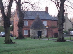
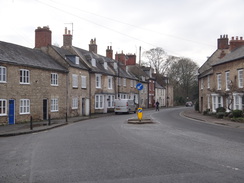
I shrugged my rucksack onto my shoulders and headed off down the road through Harrold. There were a couple of different routes to reach the Three Shires Way, and I chose the longest one, which followed a bridleway that headed northwestwards from the village. Children were waiting outside the village shop - presumably for a school bus - and I decided not to nip in, and instead strode on through the pretty village. A road led away, and when it ended a broad track stated climbing gently uphill. Whilst this was muddy in places, it was not too bad, and soon I was walking through, and then parallel to, an area of woodland.
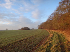
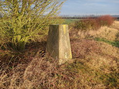
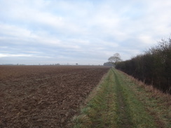
An unexpected trig pillar stood near Harrold Park Farm - I had not seen it on the map, and it is the first 'new' trig pillar I have found in ages. The Three Shires Way runs along the other side of the hedge, so I joined it and started following it southwestwards. The ground was fairly boggy, with pools of water laying in depressions in the grass. I diverted around the worst bits, but sadly it marked the start of what was to be a rather muddy and strenuous stroll. Routefinding was very simple: I just had to keep a hedge to the left as the path passed a series of fields. There were no gates or stiles, and gaps in the hedges allowed me to pass between the fields - obviously this area has always been arable.
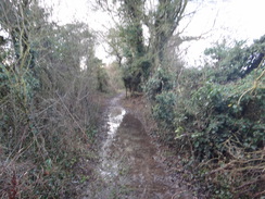
Eventually the path joined a track that led down to the A428 road. A good track led on the other side towards a farm, but the trail soon left this to head across a field. At the end of the field a gate led to a narrow path that ran between hedges. Sadly, however, the path was not just muddy, but actually flooded. The vegetation on either side meant that a diversion was impossible, and so I just waded through. My trousers, already slightly muddy, became thoroughly encased in a thick layer of mud. Fortunately things improved as the path started to descend, but I emerged out onto an access road near Lavendon Grange thoroughly muddy and a little annoyed.
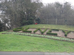
I decided not to continue along the Three Shires Way towards Olney, and instead headed off down the access road. This diversion was drier, but all too soon it ended at the busy A509. Fortunately the verge was wide, and I could step off the tarmac to avoid traffic when it approached. After about a mile the road descended to meet a roundabout on the northern outskirts of Olney. The welcome sign declared the town to be 'the home of Amazing Grace', which I later discovered was about the hymn, rather than a person. A grassy bank on one side of the roundabout has 'OLNEY' written in a small hedge; the bank itself is the site of a landscaped abutment that once carried the Bedford to Northampton railway line over the road.
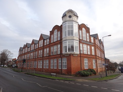
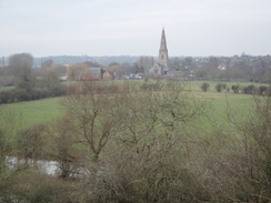
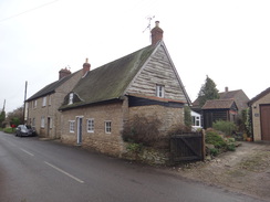
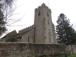
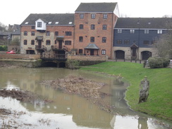
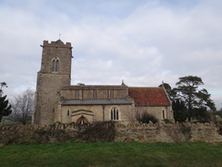
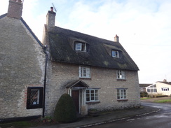
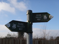
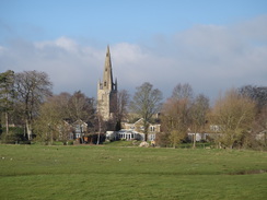
I'd never been to Olney before, and I discovered that I quite liked it. There were some attractive buildings, including a large ex-industrial building with an elaborate projecting corner window. A little further on, a stone building set back from the road had engraved stones commemorating Olney's lace industry. I nipped into a shop to buy some snacks and munched them as I headed towards the town's attractive church where, after nine miles, I finally reached the Ouse Valley Way, the main reason for the day's walk.
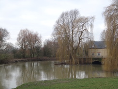
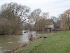
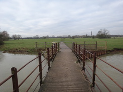
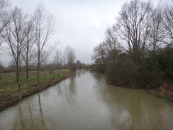
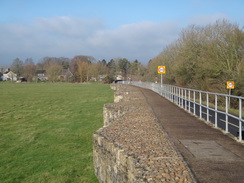
I was a little concerned that the heavy rains that had caused the boggy ground might also have led to some riparian flooding. The trail leaves the town along the floodplain, and there were some attractive views back past the swollen river to the church and an old mill. Thankfully the river had not burst its banks, and I managed to easily negotiate a few muddy sections as I crossed a stream on a footbridge to reach the main bridge over the river. The path on the other side had stones placed in it, presumably to give traction in the mud, but they had the opposite effect on my boots and I slipped and slid to the start of a steep climb up a hillside.
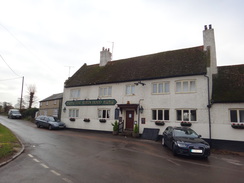
Like many trails that follow rivers, at times the Ouse Valley Way has only a passing relationship with 'its' river, and the climb marked a lengthy diversion from the water. The top of the climb offered some good views back over Olney, before a path through a field - including a very muddy section by a gate - led on towards Clifton Reynes. Sadly the village pub was not yet open - a problem with starting so early in the morning - and so I continued on along more paths that were thankfully much firmer underfoot to the village of Newton Blossomville.
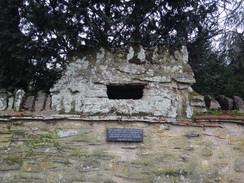
This was another pleasant village, and I was amused to see a little rectangular hole built into the top of a stone wall beside the road. A plaque underneath stated that it was a loophole that had been built by the local Home Guard in 1940. It seemed both incongruous and unobtrusive, and I would have easily missed it had it not been for the plaque. After skirting the churchyard, a path took me down to cross the river once more on a series of footbridges. A footpath diversion sign showed that these were brand new, and that they take the path over the river in a slight different location to the old bridges.
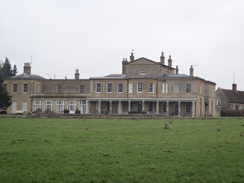
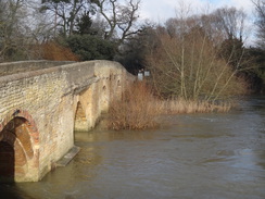
A climb uphill offered a few glimpses of Brayfield House, which from the outside appeared quite a sizable and elegant pad. This was followed by a long walk along the A428 across Turvey Bridge into Turvey. Like all the villages encountered today, this was a quaint and pleasant place - or at least it would have been if a main road did not run through it. The river itself was not quite in flood, but it displayed an angry face rather than a bucolic calm. A statue standing between two channels nearly had wet feet, and I wondered if it would survive a full flood.
An unusual feature took me off the main road: an archway between two houses marked a narrow path that led between houses; this would have been easy to miss if I had not been expecting it. Unfortunately a check of the map when I got back home shows that this was a mistake: the trail actually takes a more pedestrian and uninteresting route along roads, and so I shall have to come back here sometime to do the few hundred yards that I missed.
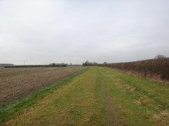
A path led north out of Turvey across fields; initially the ground was firm underfoot, but eventually it left the field boundaries to cut diagonally across the fields. They had recently been ploughed, and the wet weather meant that my boots were soon caked with a heavy half-inch layer of mud that made every step much harder. I eventually reached the other side of the field, and I decided to walk around the edge of the next field rather than cut across. It was a relief when a grassy path led down to Carlton church, which is situated on its own outside the village.
Unfortunately my escape from mud was short-lived, as the field next to the church was waterlogged. I diverted around the worst parts, but it was still a highly unpleasant stroll. Again, it appears from my map that this was actually the incorrect route, and that the trail sticks to a drier route via roads into Carlton. This mistake, along with the one in Turvey, is annoying: an old map I have shows the routes I walked, but the latest online OS maps show the other routes - presumably these are areas where the trail's route has changed.
I was relieved that the last stretch of trail from Carlton to Harrold was along roads; fortunately there was a raised path alongside the narrow road for most of the way, meaning I only had to brave the traffic on the bridge over the river, which is controlled by traffic lights. I was soon back at my car, with my trousers and boots looking like I had been wrestling with a mud-monster in a swamp. It had been a good walk; in better conditions it would have been very enjoyable, but the mud and waterlogged ground had made it a day more to be endured than enjoyed.
 |
 |
|
Directions
This walk starts off at the car park in Harrold Country Park at SP95625667. Leave the country park and turn right to walk north along Carlton Road, away from the river bridge; there is a pavement on the left-hand side of the road. Take the first significant road off to the left, High Street, and follow it as it heads west through the centre of the village. Pass a war memorial and bandstand on a green on the left, and continue on until the Oakley Arms is reached on the right. Walk past this, and a few yards further on, opposite The Muntjac pub, turn right up Orchard Lane.
Orchard Lane heads north out of the village; a stream joins on the right, and the road curves to the left as its surfacing ends. A green lane continues on uphill between hedges, passing some allotments through the hedge on the left as it climbs. When the lane ends, go through a gap in a wooden fence ahead to enter a field. Follow a hedge on the left to the field's corner, where it meets the southern edge of Park Wood. Turn left through a gap in a broad hedge into another field, and then turn right to follow the edge of the woodland on the right. After 250 metres turn right through a gap in the trees to enter the woodland.
Follow the obvious path northwestwards through the trees for a quarter of a mile, until it crosses an access track and leaves through a gap in a hedge into a field. Turn half-left to follow the edge of the woodland west-northwestwards for half a mile, aiming for a large barn at Harrold Park Farm ahead. At the end of the field, cross an access track and a small area of concrete paving to pass a corner of the barn on the left. Skirt a hedge on the right for a few yards to reach a gap in a hedge ahead that leads into another field. Head straight on northwestwards across this field for 150 metres; at the end of the field pass a trig pillar on the left and cross a plank bridge over a ditch to reach a green track that runs along the edge of another field at SP92375884.
Here the Three Shires Way long-distance path is joined. Turn left to follow the hedge on the left southwestwards; the next three miles mostly follows the hedge on the left across a series of fields, with gaps leading from one field to the next. The path passes through two small areas of woodland, but it is always easy to follow. After 2.5 miles a track is met by a bridge over a ditch; continue along this track until the A428 road is reached at SP90545433.
Carefully cross the road, and on the other side turn right for a few yards to reach a farm entrance. Turn left down the farm access track, which follows a hedge on the right. When the track soon curves to the right, head straight on to a bridleway gate that leads through a fence into a field. Follow an intermittent hedge on the right down the field; in the far corner go through a gate to join a narrow section of path that is constrained by hedges on both sides. This curves to the right and left as it falls, and ends at an access track beside a house on the left. Turn left down the track, and follow it past a wall belonging to Lavendon Grange on the left, until a junction of tracks is reached at SP90105351.
Here the Three Shires Way is left; turn right along a surfaced road, and follow this west-southwestwards for a third of a mile until it meets the A509 road. Carefully cross the road, and turn left to follow it southwestwards. The road is fairly busy, but the grass verge on the right-hand side is wide. The road rises and curves to the right, before turning to the left and descending towards Olney. After half a mile a pavement starts on the left, and another quarter of a mile further on a roundabout with the B565 road is reached on the northern outskirts of the town. Cross the roundabout to join a pavement on the left-hand side of the road. Follow the road south through the town for 0.8 miles; shortly before the bridge over the river is reached, Lime Street joins from the right at SP88875103.
Here turn left off the A509 past cycle barriers onto a path that heads towards the church; this is now the Ouse Valley Way, which will be followed (mostly!) for the rest of the day. Go through a gate into the churchyard and take a left-hand fork to pass the church on the right at SP88975098.
Pass the church on the right, and exit through a gate onto Church Lane. Turn right down the lane, and when it soon ends at a gateway, take a concrete path that runs between a low wall on the left and a fence on the right. The path emerges through a gate into a field with the river to the right. As the river curves to the right, go through a gateway in a fence and angle slightly left, aiming for a low footbridge over a stream ahead. Cross this, and then turn slightly left to head east towards a larger footbridge over the river. Go through a field gate in front of the bridge, and cross the bridge.
On the other side go through a pedestrian gate and follow the path as it turns left to head north for a short distance alongside the river to the left. The path then curves right over two small footbridges over channels, and then turns left to climb steeply uphill along a grassy path to the northeast. At the top, follow a fence on the right; as the fence curves right, turn left through a clappergate about five yards before a field gate is reached. Cross a field, aiming for houses ahead. At the end of the field, go through a clappergate to join a track. Turn left down this track; after a few yards it becomes a road called Church Lane in Clifton Reynes at SP89955133.
Head straight on along this road, which soon curves to the right with the church away to the left. After a fifth of a mile the Robin Hood pub is reached on the right; here turn left along Spring Lane. This curves to the right, and when a sharp left-hand bend is reached after a fifth of a mile (with the road heading towards a bridge over an old railway line), turn right to join a footpath that cuts straight across a field east-southeastwards. When the path reaches the far corner of the field, cross a plank footbridge over a ditch and squeeze through a hedge, and then angle half-right for a few yards to a plank footbridge over another ditch. On the other side, turn left to follow a hedge on the left eastwards; at the corner of the field, go through a broad gap in a hedge to meet a surfaced track. Turn left down the track and then immediately right to join a broad path that runs between hedges (this path is actually the course of the old railway line). After about twenty yards, turn left through a gap in the hedge into another field. Follow a ditch and hedge on the left; the path curves slightly to the right and passes under power lines before emerging out through a gap in a hedge onto Clifton Road in Newton Blossomville. Turn left to head straight on along this road into the village; after nearly half a mile the road curves to the left. Shortly after this bend, turn left down a surfaced track that angles away to reach Newton Blossomville church at SP92555159.
Do not enter the churchyard and instead continue on along a surfaced bridleway. Go through a bridleway gate and continue along the surfaced path past the churchyard on the right. The path heads north from the church and soon reaches three footbridges over streams of the river. After the third bridge go through a bridleway gate and turn half-right up a gravel path for about five yards, and then left along a path that runs through an avenue of trees. Go through a gate and then pass a stone wall on the left for fifteen yards to a second gate. Enter a field on the other side, and continue on with a hedge on the left. At the end of this field, go through another gate and then turn right to reach the A428 road to the east of Cold Brayfield. Turn right to follow this road eastwards; there is a pavement on the right. After a third of a mile the road crosses a couple of bridges over the river; continue on into Turvey until a junction with Carlton Road is reached on the left at SP94065240.
Continue on along the main road; the road curves to the right and after a sixth of a mile an archway through a house is reached on the left next to a post box in a wall. Go through this archway to join a footpath that heads northwards between walls, which emerges out onto May Road. Turn left along May Road for a few yards, and then right to start following Grove Road.
The proper Ouse Valley Way route Enter Turvey along the A428, passing Ye Three Fyshes on the right. Carefully cross the road to join the pavement on the other (northern) side, and then take the first road off to the left, Carlton Road. This soon passes The Three Cranes and the village war memorial on the left. The road curves to the right; take the first road off to the left, Carlton Road. Follow this through the village and then take the first road off to the right, May Road. Head eastwards down this for nearly 200 metres until Grove Road is reached on the left. Here, the route described above is joined.
When this road curves to the right, turn left to head straight on along a footpath that squeezes past a farm gate to enter playing fields. Head across the playing fields, and at the far side go through a pedestrian gate into a field; head straight on along an obvious path across the field. The path descends slightly and meets a small ditch on the right. A short distance further on a bridge leads across the ditch into another field. The path runs across the middle of the field; at the far end cross a footbridge over a ditch and go through a gap in a hedge. Immediately on the other side, cross a rough track and continue straight on across another field, aiming for a hedge-corner ahead at SP94615386.
Go through a very wide gap in the corner of the hedge, and turn half-right across the field towards the far corner. In the far corner, cross a rough track and go through a gap in a hedge to reach a plank footbridge and clappergate that lead into another field. Head diagonally across this field, aiming for a point halfway up the hedge on the right, where a clappergate leads into a field. Angle half-left across the field towards another clappergate. Go through this, cross a plank footbridge over a ditch, and then squeeze through a hedge to enter another field. Head straight on north across this field, aiming about ten yards to the left of a gap in the hedge, where a clappergate sits under a small tree. This leads into another field; head straight on aiming, for a church ahead. At the bottom right-hand corner of the field, go through another clappergate to reach Turvey Road opposite Carlton church at SP95155480.
Turn right along the road to pass the church, and then turn left along a footpath that skirts the churchyard's boundary wall on the left. A clappergate leads into a field. Follow the hedge on the left, and near the top of the field angle slightly right across the corner to reach a clappergate in the hedge. This leads into a small paddock area. Head on, following a boundary on the right, to another clappergate just before a farm gate. This leads to a path that follows a fence on the left and a hedge on the right. Go through another clappergate and continue along the path. The path curves sharply to the left and then right and passes under an overhanging house to reach the High Street in Carlton at SP95325533. Turn left to follow the road northwards; it soon curves to the right to take a more northeasterly course. After nearly half a mile, the road ends at a T-junction with Bridgend.
The proper Ouse Valley Way route Pass Carlton church on the left, and continue along the road as it curves to the left; there is a good pavement. It curves to the left once more to enter Carlton. Ignore the High Street leading off to the left, and continue along the road as it becomes The Causeway. When it ends at a T-junction, turn left up Bridgend. Pass the Royal Oak on the left, and as The Moor comes in from the left, join the pavement on the left.
Turn slightly left to join a surfaced path that initially follows a low stone wall on the left; the wall soon becomes a fence, and the path soon curves to the right and then left to parallel the road. Initially the path is raised above the road, but it slowly falls to the same level. Cross a track coming in from the left, and follow the roadside path as it climbs up onto a raised walkway. After 300 metres the path ends at Harrold Bridge over the river; here there is no pavement, so care is needed when crossing, although this is helped by the fact the bridge is guarded by traffic lights, so the traffic only comes from one direction at a time. Continue on for a couple of hundred metres after the bridge until the entrance to Harrold Odell Country Park is reached at SP95595667.
 |
 |
|
Distances
| From | To | Distance (m) | Ascent (ft) | Descent (ft) |
|---|---|---|---|---|
| Harrold | Harrold Park Farm | 2.8 | 230 | 36 |
| Harrold Park Farm | Olney church | 5.6 | 72 | 243 |
| Olney church | Turvey | 4.1 | 164 | 164 |
| Turvey | Harrold | 3.2 | 75 | 98 |
This makes a total distance of 15.8 miles, with 541 feet of ascent and 541 feet of descent.
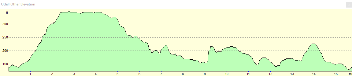
For more information on profiles, ascents and descents, see this page
 |
 |
|
 |
 |
|
 |
 |
|
 |
 |
|
 |
 |
|
 |
 |
|
 |
 |
|
 |
 |
|
 |
 |
|
 |
Disclaimer
Please note that I take no responsibility for anything that may happen when following these directions. If you intend to follow this route, then please use the relevant maps and check the route out before you go out. As always when walking, use common sense and you should be fine.
If you find any information on any of these routes that is inaccurate, or you wish to add anything, then please email me.
All images on this site are © of the author. Any reproduction, retransmissions, or republication of all or part of any document found on this site is expressly prohibited, unless the author has explicitly granted its prior written consent to so reproduce, retransmit, or republish the material. All other rights reserved.
Although this site includes links providing convenient direct access to other Internet sites, I do not endorse, approve, certify or make warranties or representations as to the accuracy of the information on these sites.
And finally, enjoy your walking!
Nearby walks
| # | Title | Walk length (miles) |
|---|---|---|
| 146 | Bletchley to Wolverton | 11.9 |
| 184 | A circular walk between Hargrave, Raunds and Rushden | 18.4 |
| 213 | Rushden to Northampton | 16.4 |
|
|

|