Walk #969: A Christmas Day walk to my birthplace
 |
 |
|
General Data
| Date Walked | 25/12/2012 |
| County | Derbyshire |
| Start Location | Barrow Upon Trent |
| End Location | Barrow Upon Trent |
| Start time | 09.35 |
| End time | 12.00 |
| Distance | 7.0 miles |
| Description | This was a short Christmas Day stroll from Barrow-upon-Trent, heading out along the Trent and Mersey Canal before returning along roads to view the floods. |
| Pack | Today I carried my 30-litre Karrimor rucksack, filled with water, my waterproofs, a book and other odds and ends. |
| Condition | I felt absolutely fine after this walk, and was ready for a good helping of Christmas dinner. |
| Weather | The morning was not too cold, but sadly it was damp, with a fine drizzle in the air for most of our stroll. |
| OS map | Landranger number 128 (Derby & Burton upon Trent) |
 |
 |
|
Map of the walk
Maps courtesy of Google Maps. Route for indicative purposes only, and may have been plotted after the walk. Please let me have comments on what you think of this new format. For a detailed table of timings for this walk, please see the table file.
 |
 |
|
Notes
It had been ten years since I last walked on Christmas Day, and with my parents in a new home, it seemed like an ideal opportunity to do so once again. Unfortunately flooding had blocked off the paths near the Trent in Barrow-upon-Trent, so I was forced to think of an alternative route. Fortunately the Trent and Mersey canal rarely floods in this area (although it does further east near its confluence with the Trent in Shardlow), and so I decided that a quick stroll along the canal was in order.
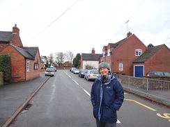
Sencan felt like a pre-meal stroll as well, so we got ready, put on our waterproofs as protection against the steady drizzle and headed off along the road. The road near the church was flooded, so we headed north, crossing a main road and bridge over the Long Easton railway line before reaching the canal.
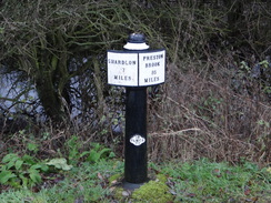
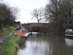
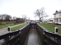
As expected the towpath was muddy and waterlogged, but there was not too many puddles to contend with. At this point the canal parallels the Castle Donnington railway line, which could occasionally be seen through the hedge on the left. A couple of cast-iron mileposts were passed before we reached Stenson Lock.
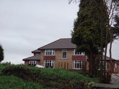
I was born in a house near the lock, so we left the canal and passed the Stenson Bubble pub to reach the house. It has recently been extended, changing the look of the house radically, with a new roof and extensions on either side. I lived in that house until I was eleven, and I was unaccountably sad to see these changes. Because of the drizzle we did not stay too long, and headed back down to the canal.
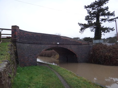
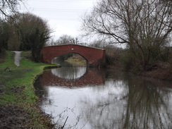
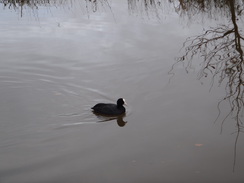
Soon the canal passed under a railway bridge that carries the Birmingham to Derby railway line overhead, then turned sharply to the left. Nearby was a man-made pond called Ballast Hole Pond whose name belied its original purpose; it was dug to provide ballast when the railway line was constructed, and was one of several in the area. Whilst many of the larger ones have been filled in with flyash from the nearby Willington power station, British Waterways dug this one out and restored it into a pond.
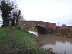
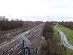
We climbed up onto Buckford Bridge, where the canal and railway line continues southwestwards. A short way away to the left was an overgrown area that once housed the coal sidings of the Barrow-on-Trent power stations. Although the power stations closed many years ago, the cooling towers are still extant, and may be used by a new gas-fired power station in the near future.
We had a choice to make at the bridge; we could continue on towards the village of Willington, or turn back. As Christmas Dinner was in a few hours we decided on a third course: to turn the walk into a circular stroll by heading back along roads, if only to see the floodwaters. We were unsure if the road at Twyford was still closed by flood waters, so it was a slightly risky gamble.
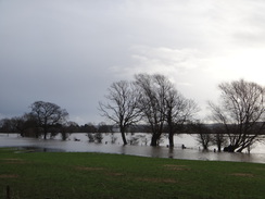
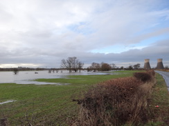
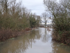
Surprisingly we came across a flood immediately by a school beside the bridge; this was localised, and we could walk along the verge to get past. I had been expecting there to be little traffic on Christmas Day, but it was busier than I expected, meaning we had to take care as cars sped past. We joined the main road and started following this back eastwards, soon reaching Twyford. The road down to the hamlet was flooded as expected, with the water only a foot away from the main road. Large puddles showed where it had once spilled over the road into a triangular junction with another road.
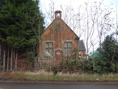
My family have had a long connection with this area - my dad lived in this area as a child, and remembers the chain ferry that once spanned the Trent from Twyford, finally closing after being damaged by floods in 1963. My uncle was taught in the old school that stands alongside the road (where he must have been amongst the last pupils), and my brother, aunt and now parents live a few miles down the road.
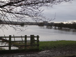
The next mile and a half was simply a case of avoiding the traffic as we followed the main road eastwards, with some fairly dramatic flooding off to our right. In places the river was a kilometre of more away from the road, yet the flooding was only a few metres away. It was an enjoyable stroll, especially when the drizzle finally ceased. Eventually we reached home, having pre-burnt off some of the turkey we were about to eat. This was an easy, if muddy walk through my past.
 |
 |
|
Directions
This walk starts off outside Barrow-upon-Trent school on Twyford Road in Barrow-upon-Trent at SK351285. Head east down the road and follow it as it curves to the left to head north; it soon ends at a T-junction with the A5132 road. Carefully cross the road, then turn right and immediately left up Sinfin Lane. The road soon starts climbing, and after a sixth of a mile it crosses a railway line on a bridge and descends slightly to a canal bridge. Do not cross the canal, and instead turn right and descend some steps to reach the towpath of the Trent and Mersey canal at SK355289.
Immediately turn left to head under the canal bridge and continue west along the towpath, with the canal on the right and the railway line through the hedge on the left. After nearly two miles, and after passing under a couple more bridge, another bridge is reached immediately in front of Stenson Lock at SK325299. Just before the bridge, take a sloping path that reaches a clapper gate that leads onto the road over the bridge. At the bridge I made a short diversion to visit the house I was born in further up the road.
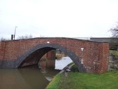
Carefully cross the road and go through another clapper gate before continuing past the lock on the right, with Stenson Marina on the other side of the canal. Continue along the towpath; after nearly half a mile it passes under a large railway bridge, after which it curves sharply to the left. Half a mile after the railway bridge, the canal approaches Buckford Bridge at SK311296. Go under the high road bridge to reach the old hump-back bridge alongside, and use this to cross the canal. Continue on north along the access road for a short distance, passing a restaurant on the left before it meets the road.
Turn right and cross the high bridge over the canal and continue along the road as it heads east past a school. After nearly half a mile a junction with the A5132 is reached at SK317294. Here turn right and follow the road eastwards; after had a mile it reaches a road junction at Twyford. Continue along the road; after 1.4 miles a junction with Twyford Road is reached on the right at Sk349285. Turn right and follow the road as it curves to the left to head east towards the start point of this walk outside Barrow-upon-Trent School.
Distances
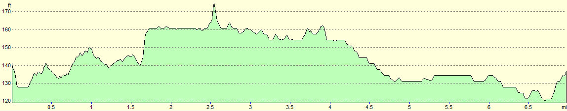
| From | To | Distance (m) | Ascent (ft) | Descent (ft) |
|---|---|---|---|---|
| Barrow-on-Trent | Buckford Bridge | 3.8 | 118 | 95 |
| Buckford Bridge | Barrow-on-Trent | 3.2 | 36 | 59 |
This makes a total distance of 7.0 miles, with 154 feet of ascent and 154 feet of descent.
For more information on profiles, ascents and descents, see this page
 |
 |
|
 |
 |
|
 |
 |
|
 |
 |
|
Disclaimer
Please note that I take no responsibility for anything that may happen when following these directions. If you intend to follow this route, then please use the relevant maps and check the route out before you go out. As always when walking, use common sense and you should be fine.
If you find any information on any of these routes that is inaccurate, or you wish to add anything, then please email me.
All images on this site are © of the author. Any reproduction, retransmissions, or republication of all or part of any document found on this site is expressly prohibited, unless the author has explicitly granted its prior written consent to so reproduce, retransmit, or republish the material. All other rights reserved.
Although this site includes links providing convenient direct access to other Internet sites, I do not endorse, approve, certify or make warranties or representations as to the accuracy of the information on these sites.
And finally, enjoy your walking!
Nearby walks
| # | Title | Walk length (miles) |
|---|---|---|
| 64 | Long Eaton to Willington | 14.0 |
| 68 | Willington to Doveridge | 12.6 |
| 581 | Burton-on-Trent to Derby | 16.3 |
|
|

|