Walk #776: A circular walk from Treorchy
 |
 |
|
General Data
| Date Walked | 07/07/2007 |
| County | Mid Glamorgan, West Glamorgan |
| Start Location | Treorchy station |
| End Location | Treorchy station |
| Start time | 08.30 |
| End time | 17.09 |
| Distance | 19.3 miles |
| Description | This was a pleasant but strenuous walk walking around the Rhondda Valley, visiting several county tops on the way. |
| Pack | Today I carried my 30-litre Karrimor rucksack, filled with waterproofs, a book and other odds and ends. |
| Condition | I am very tired after this walk, which is to be expected after such a strenuous stroll. The major problem though is the underside of my feet, which are aching a great deal and were quite painful by the end of the day. |
| Weather | Today was a mixture of sunshine and cloud, with some sunny periods mainly overhelmed by periosd of patchys clouds. It was a fairly warm day, and there was only a slight breeze to help me cool down. |
| OS map | Landranger number 170 (Vale of Glamorgan, Rhondda & Porthcawl) |
 |
 |
|
 |
 |
|
Map of the walk
Maps courtesy of Google Maps. Route for indicative purposes only, and may have been plotted after the walk. Please let me have comments on what you think of this new format. For a detailed table of timings for this walk, please see the table file.
 |
 |
|
 |
 |
|
Notes
I woke up refreshed after a good night's sleep in my tent, interrupted only by music from the adjacent tents after midnight. When asked they switched the music off, and I could go back to welcome and much-needed sleep. In the morning I listened to the radio for a bit, before packing up my rucksack and starting the drive to the start of the walk that I wanted to do today.
The major point of this three-day trip was to visit as may of the South Wales county tops as possible, and for today I had planned a walk that would visit three of these. I found the drive from the campsite to Treorchy to be fairly exhilarating as the road rose from the Tower Colliery in a couple of hairpin bends before dropping down into the Rhondda Valley. Here it was unclear where I could park,and eventually I found somewhere convenient right beside Treorchy station.
A train was just pulling in as I was getting my kit together, but had gone by the time that I strode away. On the station building there was a football shirt covered in signatures - apparently a poignant memorial to a teenager who died. Some steps took me up to the main road, and I started following this southwesstwards through the outskirts of the town, and when this turned sharply to the right I continued straight on up another local road.
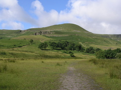
As this climbed I stopped off at a shop to buy a few provisions for the day, and once I restarted I was surprised to see a couple of sheep lazing around on a side road. The village was obviously an ex-mining one, but as I walked up I could see precious little evidence of the industry. Once the road ended I was faced with a climb up past Graig Fach, and indeed there was a footpath sign pointing up the hill, and an obvious track heading away from it.
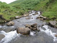
The track was easy to follow as it immediately started climbing, and I listened to my Walkman for a few minutes before realising that I was on totally the wrong hillside. Down to my left there was a large stream, and I could see from my map that the stream should have been on my left. A quick look at my GPS showed that there was no other feasible route the way that I was heading, and as there was a vague path visible crossing the stream I started the descent towards that.
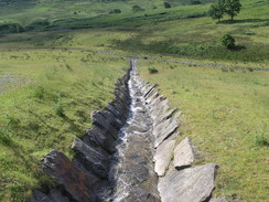
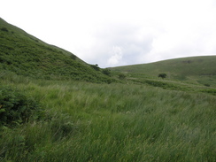
On the way I crossed a series of parallel drainage channels running down the hillside, some lined with slabs of stone that told me immediately that this was a sign of the old colliery, with the channels designed to reduce run-off from what I guessed were landscaped spoil heaps. The landscaping had been very well done, and from a distance there was little to show that this hillside was all man-made. I soon reached the stream, and the large jumbled stones in the stream bed made it easy if somewhat precarious to cross the stream.
Once across it seemed sensible to continue along the little footpath, even if it did seem to be taking me slightly away from the proper route; at least I was now on the right side of the stream. On this path there was slightly more evidence of the area's industrial heritage; a rusting pipe here, some low and barely visible ruins there. After a few minutes on this path I cut uphill across the low shrubbery to reach a track that skirted around the hill above, and after another few minutes I started to cut directly uphill to try and reach another footpath that I could see.
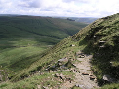
This ascent was steep and slightly tricky, but I took my time and eventually reached the path, which was narrow but easy enough to follow. By this point the vast majority of the climb had been completed, and I strode along the path that became increasingly indistinct as it headed towards the main road. This was fairly quiet as I followed it for a short distance, before turning off to climb up to the first county top of the day, the summit of Werfa.
The track climbed, at time steeply, but as the large masts at the summit get larger in front of me a large pile of dumped rubbish, some items of which were quite large, warned me that this was not going to be a classic top. There was more debris around the fence that protected the masts, and as I walked behind the compound I started to cross an area of boggy ground, with large murky puddles on the ground.
My first glimpse of the trig pillar showed that there was something wrong, and as I approached it became clear that the pillar had been heavily damaged. There was nothing left of the top of it, with the metal pipe sticking out into the air, and the flush bracket had been wrenched off. It was a sad end for a pillar and I did not feel like hanging around for too long. It looked like the highest point might be somewhere nearby, but there was virtually nothing in it and as I did not fancy more bog-hopping so early in the day I headed back towards the compound.
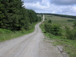
It did not take long for me to walk back down the track to the main road, which was followed for a short distandce3 to a car park at the apex of a hairpin in the road. This marked the start of several miles of tracks through forests, although the first mile was mainly through an area of cleared trees, the stumps improving the views but also making the area look like a grey, devastated moonscape.
The walk through the forestry was fairly uninteresting; the route was easy to follow along good forest tracks that were surprisingly quiet, with few people about. At one point there seemed to be a little quarry that was still in use, providing stone for the tracks, and later on some cyclists passed by me, moving fast along the tracks. At the final climb up to my next target, a trig pillar at Garn Foch, three off-road bikers roared past me up the hill, leaving a cloud of dust rising into the air behind them.
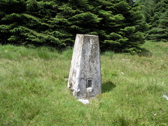
At the top of this climb there was a memorial to a young boy who had died after getting lost up here; in the sunshine it seemed such a wonderful place, but I can imagine how cold it could get in winter, or when the wind was blowing a gale. It was a sobering moment, and I plodded on for the short distance to the trig pillar, which was situated in a clearing a short distance down a track near a mast.
I took my rucksack off and sat down on the ground for a few minutes, enjoying the rest as by now my feet were really starting to ache. The immediate area around here is home to several county tops, and after I was rested I walked around for a few minutes in order to find a couple of these, although the ground was so rough and tummocky it was really hard to find exactly where they might be, and I had to go with the GPS coordinates that I had written down.
After I had reshouldered my rucksack I headed off back along the track, joining another for a short distance before taking a narrow path through the trees northwards to another county highest point, situated about halfway along this short track. Again this was hard to find, and I had to use my GPS in order to find the highest tummocks. I soon moved on from here, continuing along the path to to another forestry track, from where suddenly some beautiful expansive views were obtained to the north. I stopped for a couple of minutes to allow these to sink in, before heading on along the rough track.
This soon reached the eastern edge of the forest, and I joined a footpath that skirted the edge of the trees, following the fence as it climbed and fell until it reached a little car park by the A4061 road. This completed my walk on the western side of the Rhondda valley, and from now on I would be on the eastern side. Initially I had to follow the main road northwards, but there was a good path off the road that helped me get there safely, event though most of the traffic was going slowly as people enjoyed the views.
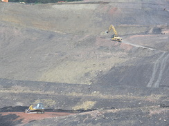
Another long walk along forestry tracks followed, and although they were firm underfoot my feet were starting to get into worse condition. The highlight of this stretch were the snatched glimpses that I got over the Lluest-wen Reservoir, but aside from this it was a rather pedestrian plod. I had planned to head down a track all of the way to Treherbert and then follow the road back to Treorchy, but as I approached the eastern edge of the forest I was greeted with signs stating that the track was closed. These are fairly common in forests for clearance works and I have never once been unable to get past, so I pressed on for a short distance around a bend to be greeted with what were full-scale construction works further down the hillside. There were large diggers and dumper trucks going up and down a steep zig-zag track and it was obvious that it would not be safe for me to go past them.
Instead I backtracked safely and headed west along a forestry track, looking for a footpath that was marked on the map heading southwestwards through the trees. I could not see where this headed off the track (when I got home my GPS track showed me that I had passed it, but it was not visible on the ground). I therefore looked at the map and devised another plan, heading back to where I had seen the construction equipment.
On the map I could see a footpath heading off down Cwm Orci a short distance to the east across the moorland, and I left the forest to walk across to this. Although rougher the moorland walking was much more enjoyable than the forest tracks, even after I ripped my trousers climbing over a fence that proved unnecessary as once I crossed it I could see a stile about a hundred feet away! Away to my right I could see the construction equipment, and this is apparently preparatory work for a large wind farm that is to be built on the hillside that I was walking over.
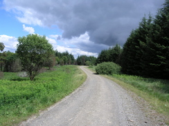
The paths were not easy to find on the moorland and I wandered around before eventually starting the steep, zig-zagging descent down to the farm at Fforch-orky. This was a strenuous descent on tired legs, and it was a relief when I joined a firm track near the farm, which became a road as it headed past a cemetery. After this I was soon back at the car, and after drinking the rest of my water supply I started the drive back to the campsite.
A shower helped me recover, and after this I went for a drive to find something to eat in Merthyr Tydfil. I ended up settling on a chain pub to the south of the town which turned out to be a big mistake - the pub was busy on the Saturday night, the food took well over an hour to arrive (fortunately I had a book to read), and when it came it was overcooked and not very tasty. It had been a strange day's walk, but very rewarding both in views and the number of county tops visited.
Directions
Note that parts of this walk were over rough ground, and followed paths that were hard to find. Please use the directions as a basis for your own walk, but take care. This walks starts off at Treorchy station. From the station platform turn left and head along a path that leads to some steps that leads up to the A4061 Station Road; at the top of the steps, turn left and follow Station Road uphill, and when the road turns sharply to the left continue straight on up Park Road.
When Park Road ends continue straight on along a signposted footpath. Do not take the track that heads uphill to the right, and instead head westwards, soon crossing a stream and continuing in a straight line uphill. This is where I went wrong, so I cannot give very good directions for it. The path will get steeper as it becomes a bridleway, crossing another stream tributary as it heads immediately to the north of Graig Fach. Once at the top the gradient levels, and the path heads southwestwards to reach the A4107 in a cutting.
Turn right and walk west along the A4107 for a couple of hundred yards until a track leads off to the left through a gate. Go through the gate and follow a track that heads uphill to the southwest for half a mile, aiming for the masts at the top of Werfa. The heavily-damaged trig pillar was situated in a boggy area at the rear of the buildings. Head back down the track towards the A4107.
When back at the road, turn left and start following it as it heads downhill to the northwest. Just as it started to curves to the left at SS917956, turn right through a gate to join a track that runs through the forest. Initially this heads northeastwards, before turning to the left to take a more northwesterly course. The track is clear and easy to follow for about five miles as it heads more or less northerly through the forest. A track junction is reached at SS907029; I headed straight on here along a grass track for a short distance to reach a trig pillar; instead, turn to the right for a few yards before turning left to head northeastwards through the forest until the Coed Morgannwg Way is reached at SS910032. Turn right and follow this eastwards. There are various tracks and paths that can be followed, but I took a wrong turning. Aim to reach the A4061 road at SS922027.
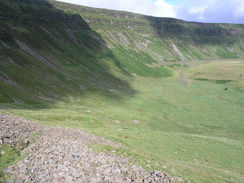
Cross the A4061 and continue along the Coed Morgannwg Way as it heads eastwards. After 0.6 miles turn right down another track at SS932026 and follow this track as it heads southeastwards. It winds around as it progresses, skirting to the south of the reservoir at Twyn Rhondda Fach. The path winds around before eventually reaching a junction at SS948994. There is a good track leading south through the woods to Pen-yr-englyn, but this was closed due to preparatory works for the windfarm on the hill.
Instead I headed east for a short distance through the woods to reach a fence at SS949994. From here I walked eastwards across the moorland for half a mile until a footpath is reached at SS955996. This was hard to find on the ground, but can be followed south as it heads along the western side of Cwm Orci. The path zig-zags around as it descends, eventually meeting a track near the farm at Fforchorsky. Continue along this track as it skirts to the north of the Nant Ynysfeio, before crossing the stream and heading south, It joins a public road next to a cemetery, and this can be followed south for nearly half a mile until it meets the A4061 in Treorchy. Turn left and follow the road southeastwards for a third of a mile, then turn right along a road that crosses the Rhondda River to reach the railway station, where this walk ends.
Distances
| From | To | Distance (m) | Ascent (ft) | Descent (ft) |
|---|---|---|---|---|
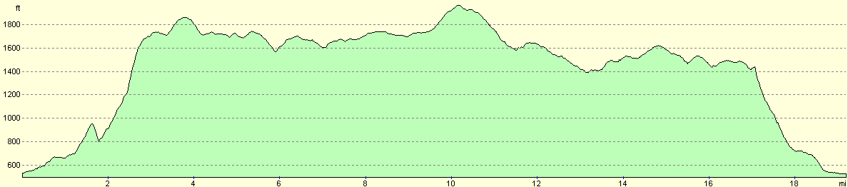
| Treorchy station | Werfa | 3.8 | 1535 | 203 |
| Werfa | Garn Fach | 6.4 | 728 | 622 |
| Garn Fach | Lluest-wan Reservoir | 3.5 | 217 | 702 |
| Lluest-wan Reservoir | Treorchy station | 5.6 | 397 | 1350 |
This makes a total distance of 19.3 miles, with 2877 feet of ascent and 2877 feet of descent.
For more information on profiles, ascents and descents, see this page
Accommodation
I spent the night at the campsite at Grawen Farm, Cwm Taf, Merthyr Tydfil, Mid Glamorgan CF48 2HS, phone (01685) 723740. This was a very nice campsite situated ideally for the Brecon Beacons and the Welsh Valleys - highly recommended.
Disclaimer
Please note that I take no responsibility for anything that may happen when following these directions. If you intend to follow this route, then please use the relevant maps and check the route out before you go out. As always when walking, use common sense and you should be fine.
If you find any information on any of these routes that is inaccurate, or you wish to add anything, then please email me.
All images on this site are © of the author. Any reproduction, retransmissions, or republication of all or part of any document found on this site is expressly prohibited, unless the author has explicitly granted its prior written consent to so reproduce, retransmit, or republish the material. All other rights reserved.
Although this site includes links providing convenient direct access to other Internet sites, I do not endorse, approve, certify or make warranties or representations as to the accuracy of the information on these sites.
And finally, enjoy your walking!
Nearby walks
| # | Title | Walk length (miles) |
|---|