Walk #726: A circular walk from Empingham to Thistleton
 |
 |
|
General Data
| Date Walked | 27/05/2006 |
| County | Rutland, Lincolnshire |
| Start Location | Empingham |
| End Location | Empingham |
| Start time | 09.25 |
| End time | 17.50 |
| Distance | 24.6 miles |
| Description | This was a varied but enjoyable stroll through the northern half of Rutland. |
| Pack | Today I carried my 30-litre Karrimor rucksack filled with my waterproofs, two litres of water, a book and various other odds and ends. |
| Condition | The biggest problem that I had today was with my feet, which got soaked early on and steamed away later on when the drizzle stopped and the sun came out. This led the underside of my feet to become fairly sore. On a positive note, I did not wear my knee braces today, and I had very little trouble with them during the day. |
| Weather | The day was generally overcast, and for a few hours there was a steady and persistent drizzle that was not heavy enough to force me to put my coat on. Later on the sun came out sporadically and the temperature rose, making the last few hours of the day quite pleasurable. |
| OS map | Landranger number 141 (Kettering, Corby & surrounding area) and Landranger number 130 (Grantham, Sleaford & Bourne) |
 |
 |
|
 |
 |
|
Map of the walk
Maps courtesy of Google Maps. Route for indicative purposes only, and may have been plotted after the walk. Please let me have comments on what you think of this new format. For a detailed table of timings for this walk, please see the table file.
 |
 |
|
 |
Notes
For some time I had been planning to do this walk to the north of Empingham, following the Viking Way northwards before crossing the A1(T) and heading back south. However I had never really got around to doing it until today, when it seemed like it may be a good alternative. Empingham is not too far away from where I live in Cambridge, and it did not take me long to get to the village, which I have walked through on several other occasions. I parked my car on a slight hill near the church and a couple of shops, and started getting my kit together ready for the walk.
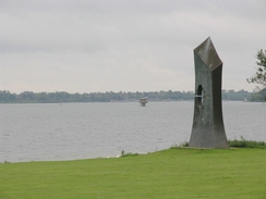
The first part of the walk took me along the Hereward Way from the village towards the dam of Rutland Water; the long grass on the descent was very wet, and fairly soon my boots were soaking, with a little water getting into my left boot through a crack in the leather. This was a sign that my boots are getting old, and I will soon have to look for a replacement pair. After climbing through a small patch of fairly scrubby woodland I crossed a field to the base of the dam, and climbed up onto the concrete path that runs along the top. The path that runs all the way around the reservoir was quite busy despite the early hour, and a few cyclists passed me as I walked along the quality path. At Sykes car park there is a strangely-shaped monument, and this was the last thing of note until I reached Whitwell Creek.
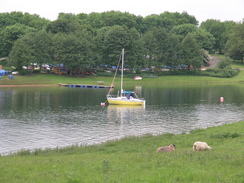
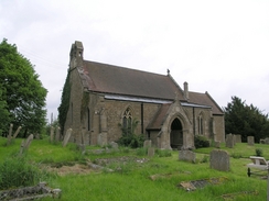
Whitwell Creek looked very pleasant despite the grey skies overhead; there were a few boats on the water, and some swans were gracefully swimming around as I walked past. On the map there was a footpath marked heading up to Whitwell Church and the main road, but I could find no trace of it on the ground. I therefore squeezed between rows of stored boats to reach the access road to Whitwell car park, and headed along it towards the church. Whitwell church is a small and fairly spartan-looking church, and is perched at the top of a high retaining wall, with the main road running beneath. Shortly after this the path reached the Noel Inn in Whitwell, a pretty-looking pub made out of the local Rutland Stone.
The path I required started from the car park of the Noel Inn, and squeezed past a children's playground before entering a field. The path headed north up a slight hill beside a low hedge, and once over the brow of the hill Exton became visible in the distance. A short jink in the path occurred before the village was reached, but I soon found myself strolling along the road that lead towards the centre of the village. Here I passed an old well of an unusual design, with six brick columns holding up a conical roof, and tried to find the path out of the village.
I was due to join the Viking Way in the village, but I could see no signpost or waymarkers to show me the way. I probably should not have found it as difficult as I did to find the path, but eventually I walked along the correct track, which led straight through the middle of a farmyard and past a small cemetery. The track continued, on, skirting the edge of Tunnelet Wood, where several cars passed me on their way to the nearby Fort Henry, before ending at the top of some old workings. These, I assume, are the remains of the old ironstone workings that were once so prevalent in the area, although nature had helped recover the area, and the only real sign that this used to be a quarry was a slight cliff-face running from west to east.
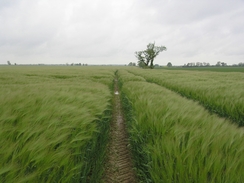
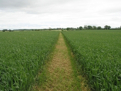
A series of tracks and paths took me northwards, slowly climbing and falling up and down a couple of slight hills, to reach Greetham. Here a road took me north for a kilometre, but when this ended a footpath took me on across a field. This was filled with a tall crop, and although a path led through the field, the adjacent crops, which were sodden from all of the rain, soon had my trousers soaking wet. This continued until another road was reached, at which time the water had penetrated my boots via my socks, and my feet were nice and wet. I therefore walked on in wet shoes and boots, to approach the northern end of the runway of RAF Cottesmore. I was disappointed that no jets were taking off, but I got a good view along the length of the runway from beside one of the runway lights At the end of the airfield was what looked like a mobile control tower, painted in red and white squares,
From the end of the runway it did not take me long to reach the village of Thistleton, which marked the northern extent of my walk for the day. It is a small village, although I chatted to a couple of people before my route took me out if it along a road, When this road turned away a track continued on towards the A1; the track was boggy and rutted in places, but I always managed to find a dry route past these, as the track was fairly wide. Once I reached the A1 it took me a few minutes to cross as the traffic was so busy; it was not a bad place to cross, however, as the views along the road in either direction were fairly good.
Once on the other side a path took me eastwards, skirting the edge of Morkery Eood, to Stocken Hall Farm, which I soon passed as another footpath took me on past some barns towards a little area of woodland. Once in the woodland the walk became bleaker as the leaves overhead blocked out the light, and the ground underfoot was muddy and waterlogged, with large puddles blocking the path occasionally. I managed to negotiate these perils before suddenly exiting the woodland to be greeted with the sigh of the walls of a prison - HMP Stocken, a Class C closed training prison. The sight of the unattractive fences and buildings within surprised me, as did the contrast with the greenery of the surrounding fields.
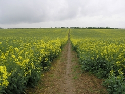
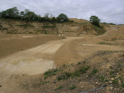
I only saw the prison for a short period as the path soon plunged into another wood, and shortly afterwards entered another field with crops in to reach the village of Clipsham. There was a pub in the village that looked fairly inviting, but one look at my soaking and muddy trousers dissuaded me from going in. Instead I walked on, and I soon found myself on a path that headed southwards once more. Fairly soon, however, the path took a diversion not marked on my map, and I found myself descending down into a very large sand quarry, with huge mounds of sand piled up against the sides of the quarry. The scale of the endeavour was breathtaking, although when I reached the bottom I was glad of the signs that pointed my way though the area. The path soon climbed out of the quarry, and I could not help but to look back at the large piles of sand within it.
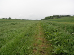
The rest of the walk to the next village, Pickworth, was along paths that were easy to follow, and I soon found myself strolling through the village. I soon met a couple of ladies with a horse-drawn buggy, and I stopped to chat to them for a couple of minutes. They were very pleasant, and one of them had ridden a horse over the South Downs Way, a National Trail that I ,myself am in the process of walking in sections. There is a bridleway that leads from the village southwards, which would have prevented about a mile and a half of road walking, but I decided to follow the road, which fortunately was nice and quiet. About halfway along the road was 'Love you' was written on the road surface in yellow paint, and I found myself wondering if it was a message to someone, or just general graffiti. As I walked I started to regret having gone along the road, as the underside of my feet, which had got very wet earlier in the day, were starting to become very sore with the constant pounding on the hard tarmac surface of the road.
The road ended at a junction in Great Casterton, and I walked through the outskirts of the village to a bridge under the A1. By now my feet were hurting even more and I just wanted to get the walk finished, so I continued along the road at a fairly brisk pace as it skirted through Tickencote before turning to head westwards. This road took me on to a junction near Cross Road Farm, where I started a descent down back towards Empingham. In the village there was one last slight hill to scale, before I started the last hundred yards down to the church and my car. I was very relieved when the walk was over, and had to admit to myself that this walk, particularly the latter half, had hardly been a classic one.
Directions
This walk starts in Church Street, by the church in Empingham. Turn left and head downhill southwards past the church for a short distance until the road ends at the A606. Turn right and pass the village church, and when the road curves to the right turn left along another residential road, Nook Lane. After a few yards the road curves to the right, and a footpath continues on downhill across a field. At the bottom the path starts to climb uphill through an area of woodland, and once it emerges it continues on to cross a stile into a field below the dam of Rutland Water reservoir.
Once across the tile turn half-right to head uphill until it reaches the northwestern end of the dam. Here join the cycle path, and start following it as it heads westwards along the northern end of the reservoir. It soon passes a small car park, and a mile later it skirts around Whitwell Creek and passes a boatyard. When the path joins a road, turn right and follow the road northwards until it ends at the A606 road in Whitwell.
Turn right along the A606 for a hundred yards until the Noel Arms is reached on the left; turn left, and walk past the pub into the car park. In the top left-hand corner of the car park is a children's play area; enter this via a gate and then join a footpath that heads northwards. This footpath climbs a slight hill, always following field boundaries, before falling to end at a road to the south of Exton. Turn left along the road for a few yards, and then at a T-junction turn right to start following a road northwards into the centre of Exton. Pass a well on the left, and shortly afterwards turn right to walk northwards up a farm track. This passes some farm buildings on the left, before curving to the right and reaching a gate beside a small cemetery.
Pass through this gate, and continue on along a wide track northeastwards that skirts the western side of Tunneley Wood. When the track curves to the right turn left along another track; when this curves to the right after a few yards, continue straight on downhill along a path in a more or less northerly direction. After a hundred yards this ends at another track; join this track and follow it as it heads up a slight hill northwards, with some woodland on the left. When the track turns to the right at the op, squeeze through the head on the left and start following a footpath that heads northwards, soon becoming a track as it heads for a little over a mile before ending at a road in Greetham.
At this road turn right for a couple of yards and then turn to the left, to start heading northwards along another road that heads out of the village. After a kilometre this ends at a junction with another road; here, head straight on along another footpath northwards. After a kilometre this crosses another road, and continues across fields towards Hobby Lodge and the northeastern end of the runway at RAF Cottesmore. The path crosses a hedge to head northwestwards with a hedge on the left, before ending after another kilometre at the road on Thistleton.
At the road turn right and start following it eastwards as it heads out of the small village. A road junction gets passed on the right, and shortly afterwards the road curves sharply to the left. Here leave the road and head straight on along a track, which becomes increasingly boggy before it finally ends at the A1. Carefully cross the A1, and once on the other side turn right and walk south along the verge for about twenty yards until the woodland on the left ends. Here, climb down some steps, and start following a footpath that heads eastwards, following the southern edge of Morkery Wood and the county border between Rutland and Lincolnshire.
When the footpath meets a track immediately to the north of Stocken Hall farm, turn right and head uphill for a few yards along the track. Just before the farm buildings are reached another footpath leads off to the left; join this footpath and follow it as it heads eastwards, immediately passing some barns on the right before running along the edge of a field. After about half a kilometre a bridleway comes in from the left; turn right and follow this bridleway as it heads southwards, dipping down to cross a little stream on a footbridge before rising up towards Little Haw Wood.
The path skirts around the western side of the wood and starts heading southwards with the wood on the left, before entering the wood. Initially it continues southwards, before turning sharply to the right to head westwards into the adjoining Addah wood. The path then skirts the edge of the woodland, just inside the trees, before bursting out into a field. The bridleway then heads southeastwards for about another kilometre, joining a track that ends at a T-junction with a road in the village of Clipsham.
Turn left along this road for a few yards, and when the road curves sharply to the left by a pub turn right to join a footpath that heads southwards. This descends to cross a stream, before climbing up the other side and is very easy to follow. Shortly after the top of the hill is reached the bridleway - which is now running along a track - turns sharply to the left, a bend that is not marked on my OS map. It then runs along the top of a quarry face for a hundred yards, before turning to the right to drop down into the quarry. Follow the signs through the quarry, but before long the path starts to rise up along a ramp to the south. Having regained the fields, it runs slightly to the east of south, with Pickworth Great Wood immediately to the east.
The path suddenly plunges into the wood for a few yards, before emerging and taking a more southeasterly course to join a track that heads east into the village of Pickworth. When the track ends at a road continue on along the road eastwards, heading through the village until a T-junction is reached. Here turn right, and start following Pickworth Road southwards for nearly five kilometres, before it ends at a crossroads in the village of Great Casterton. Turn right at this crossroads, and follow the Old Great North Road northwestwards for a few hundred yards. When a 'Y' is reached in the road, follow the fork off to the left, which heads under the A1 before curing to head northwestwards into Tickencote.
Just before the road ends at the A1, turn left along another road and then immediately to the right, to follow another rod. This road parallels the A1 for a couple of hundred yards before curving to the left to head in a more westerly direction for a couple of kilometres. When a crossroads is reached near Cross Roads Farm, turn left and start following a road that heads southwestwards, slowly descending to reach the eastern edge of the village of Empingham. The road then rises as it heads westwards through the village; continue along it until a crossroads is reached, with Church Strtte heading downhill to the left. Turn left and head down Church Street for a hundred yards until the church is reached; this is where the walk ends.
Distances
| From | To | Distance (m) | Ascent (ft) | Descent (ft) |
|---|---|---|---|---|
| Empingham | Greetham | 6.6 | 463 | 291 |
| Greetham | A1(T) | 4.8 | 167 | 134 |
| A1(T) | Pickworth | 6.4 | 282 | 471 |
| Pickworth | Empingham | 6.8 | 400 | 416 |
This makes a total distance of 24.6 miles, with 1312 feet of ascent and 1312 feet of descent.
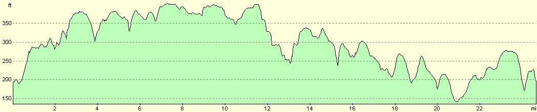
For more information on profiles, ascents and descents, see this page
Disclaimer
Please note that I take no responsibility for anything that may happen when following these directions. If you intend to follow this route, then please use the relevant maps and check the route out before you go out. As always when walking, use common sense and you should be fine.
If you find any information on any of these routes that is inaccurate, or you wish to add anything, then please email me.
All images on this site are © of the author. Any reproduction, retransmissions, or republication of all or part of any document found on this site is expressly prohibited, unless the author has explicitly granted its prior written consent to so reproduce, retransmit, or republish the material. All other rights reserved.
Although this site includes links providing convenient direct access to other Internet sites, I do not endorse, approve, certify or make warranties or representations as to the accuracy of the information on these sites.
And finally, enjoy your walking!
Nearby walks
| # | Title | Walk length (miles) |
|---|---|---|
| 56 | Peterborough to Stamford | 16.5 |
| 58 | Stamford to Oakham | 16.8 |
| 59 | Oakham to Melton Mowbray | 10.6 |
|
|

|