Walk #637: Nuneaton to Tamworth
 |
 |
|
General Data
| Date Walked | 15/12/2004 |
| County | Warwickshire, Staffordshire |
| Start Location | Nuneaton |
| End Location | Tamworth |
| Start time | 09.09 |
| End time | 14.49 |
| Distance | 18.4 miles |
| Description | This was an enjoyable canal side walk, with plenty to see and keep me interested as I walked. |
| Pack | Today I carried my 30-litre Karrimor HotRock rucksack, which was filled with three litres of water, a spare fleece, waterproofs and various electronic gadgets. |
| Condition | Aside from a slight ache in the underside of my feet I feel fine after this walk, and I could easily have walked further if I had needed to. |
| Weather | There was a little bit of drizzle in the air at times, and occasionally there were some very grey clouds overhead, but despite these it fortunately never rained. It was a reasonably mild day for the time of year, but the wind could be biting when I was exposed to it. |
| OS map | Landranger number 140 (Leicester, Coventry & Rugby) and Landranger number 139 (Birmingham & Wolverhampton) |
 |
 |
|
 |
Map of the walk
Maps courtesy of Google Maps. Route for indicative purposes only, and may have been plotted after the walk. Please let me have comments on what you think of this new format. For a detailed table of timings for this walk, please see the table file.
Notes
I had been up in Derbyshire to attend my maternal grandmothers funeral yesterday, and instead of going straight back to work I decided to do a walk. I had planned to walk the Coventry Canal between Nuneaton and Tamworth as part of a plan to follow the canal network as far as Rugeley to connect up with other walks, and this was another stage in that larger plan. I arrived at Tamworth Station later than I had been planning, and after buying a parking ticket I put my rucksack on and walked to the station to check the train times back from Tamworth.
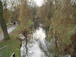
To get to the Coventry Canal at the point where I had left it earlier in the year I had to retrace my route, which was a fairly boring walk of a mile following the A444 south from the town centre. I was quite relieved when I finally joined the canal, and could start following it northwestwards out of the town. The towpath was fairly deserted as I walked along it, with only the occasional person to be seen. To the west of Nuneaton I could see down into a massively deep hole on the other side of the canal; this marked the site of a large quarry that was a massive scar on the landscape. Near this was a conical hill that was a spoil heap from the quarry, and which is apparently a prominent local landmark.
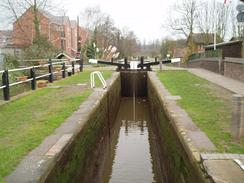
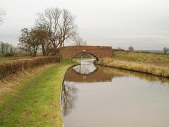
The stretch of the Coventry Canal between Nuneaton and Atherstone made for a pleasantly rural amble, and I could maintain a nice quick pace along the relatively good quality towpath. In Atherstone I soon reached the top of the Atherstone flight of locks, and I noticed a series of plaques stating the rewards that this pleasant lock and bridge complex had won over the years. There were not many boats using the canal, and the only ones that I saw moving were in a couple of the locks. The lock complex continued on as the canal head northwestwards towards Polesworth, the flight ending just before the bridge at Bradley Green was reached.
Another fairly rural scene followed, before I reached a large and intrusive railway bridge just before Polesworth. I hurried on as the canal went through the village, the only significant thing of note being the massively attractive Pooley Hall, situated on a hill to the west of the canal just before the bridge under the M42 was reached. Pooley Hall is believed to include the remains of a fortified manor house, built around 1509 (thus making it one of the oldest brick-built buildings in Warwickshire), although try as I might I could not really get too good a view of the hall from the canal. After the M42 the character of the canal changed as it started to approach the eastern outskirts of Tamworth. I passed a large marina that housed a fleet of narrow boats with the same colour scheme before houses on either side hemmed in the canal as it passed through the suburbs of Nuneaton.
The canal curved to take a more southwesterly course as it passed through Bolehall and I soon reached a couple of locks; at the second of these a man was using a gas burner to clean off the brickwork at the side of the lock. Shortly after this the canal passed under a railway bridge, and I left the towpath to join a road that headed north towards the centre of Tamworth. I was unsure how I was going to navigate past a series of roundabouts in the town, but fortunately there was a path that led me under these and I soon found myself at the southern bank of the River Anker.
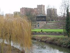
I followed the river westwards for a short distance until I saw the best sight of the day so far - Tamworth Castle, standing surprisingly complete on a hill near the river. I could not resist the temptation to climb up to it, and I had a good look around the outside of it and took several photographs of the scenic view. Under the access path to the castle there was some herringbone walling, a style that I thought was only associated with Cornwall. The castle was originally a Norman Motte and Bailey type, but the oldest parts of the existing castle are a 13th century doorway from a later rebuilding. Eventually I managed to pull myself away from the castle, and I headed towards the centre of the town, which was bustling with Christmas shoppers, I was quite impressed with the centre of the town, and there was much of interest to see as I headed along roads towards the railway station.
I arrived at the station in plenty of time for my train, and after purchasing my ticket I went into the buffet and bought myself a lovely cup of hot chocolate, which warmed me up as I waited for my train on the high level Trent Valley platforms. Tamworth is an unusual station as it is really two stations laid at right angles to each other, with the Trent Valley platforms lying above those of the Derby to Birmingham line. As I sipped the chocolate I looked back on an enjoyable, easy stroll, and another line marked off on my map of walks.
Directions
This walk starts off at Nuneaton railway station. Leave the station and head southwestwards down the short approach road, passing a car park on the right before reaching the ring road. Cross the ring road, and follow a main road south past the eastern edge of the city centre for a few hundred yards until it meets the A444 Victoria Street. Turn right to follow the A444 westwards for a short distance as it crosses the narrow River Anker and a junction with the A444 Coton Road is reached on the left. Turn left down this road, and follow it as it heads southwards to a large roundabout with the A4254, with a railway viaduct bisecting the roundabout. Cross the roundabout and continue on up a slight hill for a couple of hundred yards until Bridge 19A over the Coventry Canal is reached.
Descend down to the canal towpath and start following it as it heads northwestwards for over sixteen miles, as it passes Atherstone and Polesworth before approaching the town of Tamworth. The canal goes through the Amington and Bolehall districts of the town, before passing under the B5000 and passing two locks and reaching bridge 74. Here leave the canal, climbing up onto the bridge and turn right to follow Kettlebrook Road northwards for a little under a kilometre until it ends at the B5000 Glascote Road. Turn left along this for a few yards to a large circular road in the centre of Tamworth. Take a pedestrian subway that leads under the road, and join the southern bank of the River Anker, which heads under the roundabout.
Follow the river westwards as it heads past the town towards the castle. When the river is parallel to the castle turn right to cross a footbridge over the river and head uphill through some formal gardens to pass the castle entrance and leave the castle grounds to enter the market in the centre of the town. Turn right, initially following George Street and then Victoria Street northeastwards. When the A453 Offadrive is reached, cross it and walk up the short entrance road to the railway station, where this walk ends. If you are catching a train back to Nuneaton then you will need to wait at the high level Trent Valley railway platforms.
Distances
| From | To | Distance (m) | Ascent (ft) | Descent (ft) |
|---|---|---|---|---|
| Nuneaton station | Atherstone | 7.9 | 305 | 292 |
| Atherstone | Tamworth station | 10.5 | 295 | 367 |
This makes a total distance of 18.4 miles, with 600 feet of ascent and 659 feet of descent.
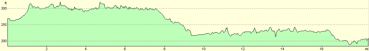
For more information on profiles, ascents and descents, see this page
Transport
There are some, infrequent, direct rail services between Tamworth and Nuneaton; at other times there are bus services that run between the two stations. I managed to get one of the direct trains, and a single ticket cost me £3.40.
Disclaimer
Please note that I take no responsibility for anything that may happen when following these directions. If you intend to follow this route, then please use the relevant maps and check the route out before you go out. As always when walking, use common sense and you should be fine.
If you find any information on any of these routes that is inaccurate, or you wish to add anything, then please email me.
All images on this site are © of the author. Any reproduction, retransmissions, or republication of all or part of any document found on this site is expressly prohibited, unless the author has explicitly granted its prior written consent to so reproduce, retransmit, or republish the material. All other rights reserved.
Although this site includes links providing convenient direct access to other Internet sites, I do not endorse, approve, certify or make warranties or representations as to the accuracy of the information on these sites.
And finally, enjoy your walking!
Nearby walks
| # | Title | Walk length (miles) |
|---|---|---|
| 610 | Rugby to Nuneaton | 19.5 |
|
|

|