Walk #636: A circular walk between Braunston and Rugby
 |
 |
|
General Data
| Date Walked | 13/12/2004 |
| County | Warwickshire, Northamptonshire |
| Start Location | Braunston Church |
| End Location | Braunston Church |
| Start time | 09.23 |
| End time | 15.28 |
| Distance | 19.0 miles |
| Description | This was a varied and fairly enjoyable figure-of-eight walk, based on the northern section of the Oxford Canal. |
| Pack | Today I carried my 30-litre Karrimor HotRock rucksack, which was filled with three litres of water, a spare fleece, waterproofs and various electronic gadgets. |
| Condition | I feel fine after this walk, and have no sign of any blisters or any associated problems. |
| Weather | It was not a bad day for a walk, and although it was reasonably cold (as is to be expected for the time of year) the walking helped keep me warm. There was thankfully no sign of any rain. |
| OS map | Landranger number 152 (Northampton & Milton Keynes), Landranger number 151 (Stratford-upon-Avon, Warwick & Banbury) and Landranger number 140 (Leicester, Coventry & Rugby) |
 |
 |
|
 |
Map of the walk
Maps courtesy of Google Maps. Route for indicative purposes only, and may have been plotted after the walk. Please let me have comments on what you think of this new format. For a detailed table of timings for this walk, please see the table file.
Notes
I had to head up to Derbyshire to go to a funeral, so I decided that I would take the opportunity to do a walk whilst I was on the way up. I had various options about walks that I could do, but I soon settled on completing one of the last stretches of the Oxford Canal that I had not yet walked - the stretch between Braunston and Rugby. I therefore found myself hanging my suit up in the car (not something I usually do before a walk), and heading off west down the A14. According to the AA route planner the journey should have taken a little over an hour, but early morning traffic and delays in Rugby meant that I did not park my car by Braunston church until two hours after I had set off.
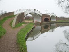
It did not take me long to get all my walking kit on, and the sun was still fairly low in the sky as I left the church behind me and headed off down a broad footpath to the A45(T) and the Grand Union Canal. There were many narrow boats moored along the initial stretch of the canal, and I enjoyed reading various little signs as I walked along a short stretch of towpath that I had followed on several other walks; Braunston has become a significant nodal point in my walks. I soon reached the fantastic double-arch bridge that crosses the junction between the Grand Union Canal and Oxford Canal (Northern section); I stopped for a couple of minutes to study these bridges and take some photographs of them as a working narrow boat chugged slowly underneath.
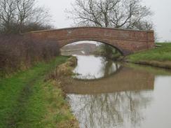
The stretch of the Oxford Canal northwards was a nice walk, and despite the fact that the towpath was not in a very good state I managed to keep a good pace up. I soon passed a couple of waterlogged walking boots lying beside the path, a strange sight that caused me to pause for a moment and wonder who they belonged to. The towpath soon started heading fairly straight to the north, paralleling the old Great Central railway line. The shallow cutting that the latter runs in was visible from the canal and I was surprised to see, over thirty years after closure of this stretch of the line, a ghostly concrete signal gantry standing sentinel beside the line. I can only assume that as it was concrete it had no scrap value, and had therefore been left when everything else was removed.
Eventually the canal curved away from the old railway line, and continued on to pass under the noisy and audibly intrusive M6. It was a relief to get the road behind me, and I strode on purposefully along the towpath, heading northeastwards towards Rugby. By the bridge under the A428 I came across my first good sight of the Rugby radio transmission masts - a multitude of tall transmission masts, reduced in number by some recent demolitions. They are usually an imposing sight, and easily visible from the M1, M6, A5 (which travels through the middle of the site) and A14, but in today's gloomy weather they were far from inspiring, which was a shame.
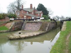
The surroundings started to get more rural as the canal turned to head northwestwards, skirting the northern outskirts of Rugby. I was aiming for the place where I had joined the canal on my previous Rugby to Nuneaton walk earlier in the year, and this meant that I had virtually the entire length of Rugby to walk. It was not a bad walk, however, and there was much to see as I strolled along, including a plethora of swans and the remains of various tall bridges over the canal, including an elegant viaduct that strode over a golf course beside the canal. Eventually I reached Bridge 59, where I had joined the canal on the previous walk, and I started following local roads south through a fairly gloomy part of Rugby towards the station.
I really did not enjoy the stroll from the station towards the centre of the town as the streets were fairly unwelcoming. I was slightly relieved when I reached the bustling market that lay surrounding a large clock tower, and I started walking through the town. The sun had not really broken through the clouds yet and I was quite cold (forgetting my gloves had been a big mistake), and so I nipped into a baker's shop to buy a couple of hot sausage rolls that I devoured ravenously before nipping into a couple of other shops to have a look for various Christmas-related items. I could not spend long doing this as I was well aware that I was only halfway through the walk and I still had a long way to walk before it got dark.
Fortunately the southern side of Rugby was much more interesting; a nice touch was that the pavements had little brass plaques set into them that stated the names of various famous Rugby players. Rugby school itself looked very nice even in the gloomy weather, and my mood improved as I strode down the road and read the plaques. I soon started leaving the town on a road that passed the hospital; it was a fairly nondescript road and there was not much to note, so I just kept my head down and plodded on. Once across the B4429 it became slightly better; the road passed the Rainsbrook Valley Railway before reaching the embankment of the long-disused Great Central Railway. The bridge over the road had long disappeared, but the embankment northwards into Rugby is now used as a walking path.
The road crossed Rains Brook, which marks the boundary between Warwickshire and Northamptonshire, before continuing on to a bridge over the M6 and then the Oxford Canal once again. Shortly after this the road curved to the left and I left it to follow a bridleway up towards the top of Barby Hill. The path was extremely muddy and was well churned up by bikes and horses' hooves. The going was consequently quite difficult, and I found it easier in places to walk along the edge of the ploughed field rather than the unploughed path. Once at the top of the hill the going became easier and I could make faster progress. I was tempted to go and visit the trig pillar at the top of the hill an diverted into a field to do so, but once I saw it I decided that I could not be bothered to climb over the various fences and turned back to the bridleway.
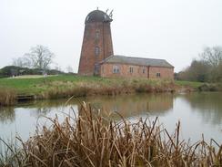
The bridleway became a track as it headed southeastwards, and met a road near a pond and the remaining stump of a windmill, which was a very pretty and photographable sight. A road led me on southeastwards for a couple of miles as the sun slowly started to go down. At Ashby Grange I nipped over a low barrier and followed a track the short distance towards a trig pillar that was virtually buried within a hedge. In the low light I found it hard to photograph, and it took me a few efforts to get a good picture of the flush bracket. A short distance further on the road met the long-distance Jurassic Way, and I turned down this and started following it southwestwards back towards Braunston.
By this time my legs were getting slightly tired and I was annoyed to see that the path went down into a little valley before climbing up the other side towards the village. The path became a track, and near the bottom there was a derelict, abandoned car, which I found to be annoying sight in such pleasant surroundings. I soon reached the road in Braunston, and walked through the pretty village and reached the church once again just as it was starting to get dark. It had been a nice and varied walk, and it had taken my mind off tomorrow's funeral for a while.
Directions
This walk starts off beside the church in Braunston. Leave the church and walk westwards for a few yards until a road junction is reached beside the church. At the junction turn left and follow a broad footpath downhill for a short distance to the A45(T) by a bridge over the Grand Union Canal. Descend down onto the canal towpath, and then start following it westwards past a series of moored boats for a few hundred yards until a double-arch bridge is reached. Walk over the bridges, and then start following the Oxford Canal (northern) section northwards for over eight miles, as it crosses the M45 and curves around the northeastern side of the town of Rugby. When Bridge 59 on the canal is reached, near the area of Rugby called Brownsover at SP511768, leave the canal and turn left to start following Boughton Road southwards.
The road slowly curves to the left and crosses the River Avon, which is little more than a stream at this point. shortly after this turn right and follow Mill Road southwards; this passes under a wide and dark railway bridge, and once on the other side turn right to start walking along Railway Terrace past the front of the station. Shortly this curves sharply to the left; take the first road to the right after this (Wood Street) and follow it westwards before turning left to walk southwestwards along Park Road. When this ends at the B5414 North Street turn left and follow this road southwards; when it curves to the left continue straight on, passing a clock tower and joining a pedestrianised street that heads down through the centre of Rugby before ending at the A428.
At the A428 turn left and follow it eastwards for about a hundred yards, before turning right down Barby Road. This heads southeastwards, passing a hospital before ending at a crossroads with the B4429 Ashlawn Road. Cross over the B4429 road, and once on the other side continue straight on down Onley Lane. The lane heads southeastwards, crossing the Rains Brook and crossing from Warwickshire into Northamptonshire, and heads on to cross the M45 and the Oxford Canal. Shortly after the canal bridge the road curves sharply to the left at the base of a hill; instead of following the road head straight on along a bridleway that starts heading southeastwards up Barby Hill. Initially this is fairly indistinct and muddy, but as it gets higher up the hill it gets firmer underfoot and eventually becomes a green lane.
The green lane becomes a track that eventually ends at a crossroads beside a stump of an old windmill, situated prettily against a lake. At the crossroads head more or less straight on, following a road southeastwards. After a couple of miles the road reached Ashby Grange, and in a hedge in a field to the left of the road immediately beyond the grange is a trig pillar. Continue on along the road for a couple of hundred yards, and then turn right to join the Jurassic Way long-distance footpath. This heads downhill to the southwest following a hedge, but as it nears the bottom of the hill it becomes a green lane that climbs up the other side of the little valley before ending at Ashby Road to the east of Braunston. Continue straight on down Ashby Road, which soon joins High Street that heads straight through the centre of the village. Continue on westwards along High Street until the church is reached on the right, where this walk ends.
Distances
| From | To | Distance (m) | Ascent (ft) | Descent (ft) |
|---|---|---|---|---|
| Braunston | Rugby | 10.4 | 240 | 322 |
| Rugby | Braunston | 8.6 | 518 | 436 |
This makes a total distance of 19.0 miles, with 758 feet of ascent and 758 feet of descent.
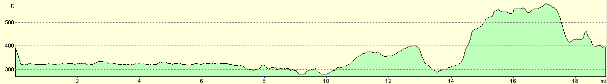
For more information on profiles, ascents and descents, see this page
Disclaimer
Please note that I take no responsibility for anything that may happen when following these directions. If you intend to follow this route, then please use the relevant maps and check the route out before you go out. As always when walking, use common sense and you should be fine.
If you find any information on any of these routes that is inaccurate, or you wish to add anything, then please email me.
All images on this site are © of the author. Any reproduction, retransmissions, or republication of all or part of any document found on this site is expressly prohibited, unless the author has explicitly granted its prior written consent to so reproduce, retransmit, or republish the material. All other rights reserved.
Although this site includes links providing convenient direct access to other Internet sites, I do not endorse, approve, certify or make warranties or representations as to the accuracy of the information on these sites.
And finally, enjoy your walking!
Nearby walks
| # | Title | Walk length (miles) |
|---|---|---|
| 158 | Bugbrooke to Braunston | 15.1 |
| 162 | Braunston to Leamington Spa | 16.6 |
| 598 | A circular walk from Badby via Lower Shuckburgh | 21.4 |
|
|

|