Walk #605: Burnsall Fell to Rain Stang
 |
 |
|
General Data
| Date Walked | 01/05/2004 |
| County | North Yorkshire |
| Start Location | Burnsall Fell |
| End Location | Rain Stang |
| Start time | 07.40 |
| End time | 17.42 |
| Distance | 19.1 miles |
| Description | This was a lovely and varied walk, taking in Great Whernside and part of the Dales Way on route. |
| Pack | Today I carried my 70-litre Craghoppers rucksack, filled with full camping kit, my Westwind tent, my Blue Kazoo sleeping bag and four days food. |
| Condition | I am quite fatigued after this walk and am quite glad that I have reached my target for the day, although perversely towards the end I could have walked a little further if I had needed to. I have a great deal of chaffing, which I am going to have to do something about before tomorrows walk. |
| Weather | The wind dominated today's weather, and it was very strong all morning and on the tops it was quite chilly, and to make maters worse it was a headwind. It was quite cloudy in the morning, but in the mid-afternoon this was replaced with lovely, bright sunshine just as the wind stopped. |
| OS map | Outdoor Leisure number 2 (Yorkshire Dales - Southern & Western Areas) and Outdoor Leisure number 30 (Yorkshire Dales - Northern & Central Areas) |
 |
 |
|
 |
 |
|
Map of the walk
Maps courtesy of Google Maps. Route for indicative purposes only, and may have been plotted after the walk. Please let me have comments on what you think of this new format. For a detailed table of timings for this walk, please see the table file.
 |
 |
|
Notes
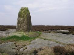
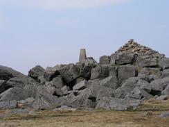
I woke up this morning to find that the wind had died down, and that a lovely red sky greeted me. I had slept reasonably well over the night, and I felt much better than I did when I went to bed. It was still far too early to start walking, and so I lay in my sleeping bag waiting for a couple of hours before I finally emerged. I had not visited the nearby trig point last night, so I packed up my rucksack and left it in my tent whilst I walked up to it. The moorland was quite rough and punctuated by many holes and dips in the ground, the legacy of mining in the area. The trig point itself was damaged at the top, and the views were not as expansive as I had been expecting due to the low and flat nature of the hill, so I headed back down the hill to the tent and started to pack up.
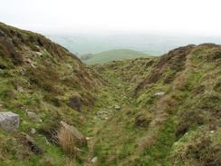
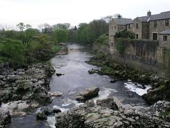
The route down off the moorland was easy to find and it headed downhill across the moorland before joining the end of a rough track at the start of the enclosed land. This led me swiftly downhill, and eventually I joined a road that led me through the pretty little village of Thorpe. Once at the main road I joined a footpath that skirted the fields before heading down to a bridge over the river at Linton Falls. This cascade in the river was a beautiful sight, and it would probably be more so if more water was flowing down it, as the river was not very full.
A stone-clad path lead uphill into the village of Grassington, where I stopped off at the Spar shop to buy some provisions, including a two-litre bottle of water and some chocolate. I sat down on a seat in the middle of the village and munched away, enjoying the sights of the beautiful buildings that surrounded me. Despite the early hour the town was bustling, and I could see several walkers getting ready to walk the next leg of the Dales Way. Eventually I realised that I could not prevaricate any longer, so I put my pack on and headed along the road uphill, pausing occasionally to peer down some exquisite cobbled streets.
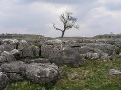
For the next few miles I followed the Dales Way as it headed across classic limestone scenery, with large stretches of limestone pavement scattered around. It was a beautiful view, although I did not really have time to look around, and the wind was gusting strongly from straight ahead, making progress more difficult. The path was quite busy with walkers, a dramatic difference to yesterday when I scarcely saw another walker. I chatted to a group of Americans who were walking the path before diverting off it along a track that headed uphill, before leaving it and heading further uphill along a footpath to a trig point.
The wind was quite chilly now and so I hunkered up behind a wall near the trig point and put my coat on for the first time on the trip, not to protect from rain but from the wind. This allowed me to set off feeling much warmer, and although the wind was still coming from ahead I felt much happier as I strode along. Fairly soon I had to leave the path and follow a fence line across the moorland, aiming for the start of Hill End. The moorland was quite rough and boggy, which meant that progress was slow and tiring. Eventually I reached the base of Hill End and I started the ascent, which was gradual at first but soon became quite steep as I progressed. It was so steep that I had to take it slowly and keep stopping to catch my breath.
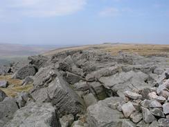
Eventually I reached the top of the climb and the gradient slackened, allowing me to make better time along a rough path towards the top of Great Whernside. When I got there I was surprised to find that the top of the hill - at 704 metres the highest point of the entire trip - was dominated by large boulders, so I hunkered down beneath one of these for a rest. For the first time today the sun had come out, and there were some great views westwards, with Pen-y-Ghent clearly visible in the distance. Despite keeping low down the wind was still affecting me, so I soon picked my pack up and headed off down the hill, which was a slow and gradual descent towards the col between Great and Little Whernside.
What then followed was a slow descent along a bridleway across some exceptionally boggy ground that was hardly enjoyable walking. The path skirted high above Angram Reservoir, and it seemed to take forever to reach the track that ran along the northern bank of Scar House Reservoir, which meant a rough and thankfully less boggy walk. I made much better time to the magnificent dam at the end of the reservoir. I crossed this and with relief reached the car park on the far side, where I took my pack off and sat down on a bench sheltered from the sun. I was low on water so I filled up my bottles and had a chocolate bar as I got my breath. I had also suffered from bad chaffing for the last few miles, so I was forced to apply Vaseline to the effected areas when I went to the toilet.
Angram Reservoir was constructed between 1903 and 1919 by the Bradford Corporation to provide water to the town. It collects water from the River Nidd and Stoney Beck, and is 130 feet high, 400 yards long and holds up to 1,042 million gallons of water. Scar House Reservoir was constructed between 1921 and 1930, and the depth of water on it is 120 feet. The reservoir holds an amazing 2,200 million gallons of water, and the dam is an impressive sight when viewed from the car park. These two dams, along with Gouthwaite Reservoir that I shall walk past tomorrow, is part of a water supply scheme for Bradford, and even the associated infrastructure involves massive engineering - The Nidd Aqueduct, which started at Scar House Reservoir, ends 31 miles away and has 11 miles of covered channels and six miles of tunnel, with an average fall of two feet per mile!
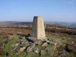
I was in two minds about whether to attempt the 120-metre climb to my planned campsite for the night, as I was quite tired. Eventually I decided to do it, and so I shouldered my rucksack and headed off. The initial stretch was along a level road past the dam, before taking a steep and winding rough track that headed uphill. This was slow going, but I was not along as a mountain biker had to get off his bike and push. The track went around a couple of hairpin bends before the gradient flattened, and I actually felt fine as I walked along. I had planned to spend the night at a trig point on Rain Stang, and so I left the track and headed uphill towards the pillar, dropping my rucksack off on a relatively level patch of grass by a stone wall before heading on to the pillar from where there were some magnificent views. After soaking some of these up for a few minutes I headed back down to my rucksack, where I made he decision to camp there, despite being tempted to walk on further, mainly due to the fact that I doubted that I would be able to find anywhere to camp lower down on the hill.
Directions
This walk starts off on Burnsall Fell at grid reference SE01187 60075, where I wild camped for the night. My initial walk of the day was a quick stroll across the moorland to the trig point at the highest point of the fell, heading south-southwestwards and avoiding the disused mineshafts that litter the area before heading back to the site where I camped.
A vague path led downhill to the north; this is marked on the map but was hardly obvious in the ground until it reached the top of Hesker Gill, where I could follow it more easily as it headed down a small but steep-sided gully and ended at a wall marking the start of the enclosed land. Go through a gate and then start walking downhill along a rough track that runs between two stone walls, before this eventually ends at a road. Continue on along this road as it heads northwards into the little hamlet of Thorpe. When the road splits in a triangular junction in the centre of the hamlet take the left-hand fork, which initially head uphill before dropping down to the northwest and ending at a junction with another road.
Turn to the left and walk northwestwards along this road for a few yards, before taking a footpath that leads off to the right, heading northwestwards across fields with the River Wharfe low down on the right. The path descends to meet a track and then Church Road; once at the road turn to the left and follow Church Lane westwards past a car park and some toilets until it curves sharply to the left. Immediately before this bend take a footpath that leads off to the right, heading for a short distance behind some houses to gain access to a bridge over the River Wharfe at Linton Falls.
Cross the bridge and on the other side follow Sedber Lane, which is lined with flagstones, northeastwards until it ends at the B6265 Hebden Road. Turn left and follow the B6265 northwestwards as it passes a car park, until a sharp bend to the left is reached. Here turn right and head northwards along Main Street, which heads straight through the centre of the village passing the post office and some shops. When a complex junction is reached at the end of the road turn half-left, to head northwestwards along Chapel Street. When this road turns sharply to the left to head downhill, turn right to join a lane; this lane is part of the Dales Way, and will be followed for the next two and a half miles.
The Dales Way is easy to follow as it heads in a rough northerly direction, crossing an area of interesting and attractive limestone pavement. At grid reference SD992682 a junction is reached with a track called Bycliffe Road, which rises along the edge of a spectacular little valley on the left. Leave the Dales Way by turning right and follow Bycliffe Road as it climbs uphill to the northeast. Once a junction is reached leave the track to the left and follow a footpath that heads northwards towards a nearby small area of woodland, following Conistone Turf Road. This climbs uphill to the northeast, passing immediately to the north of some crags before reaching the trig point at Capplestone Gate.
Climb a ladders tile over a wall immediately to the south of the trig point, and then turn to the left to follow a distinct path north-northwestwards along the edge of the enclosed land. Near SD998709 a wire fence leads off to the right; cross this fence so that you are on the northern side of it, and then turn right to start following it across the moorland. Keep the fence to the right as it swings to the left and then the right across a boggy area, before eventually settling on a climb along firmer ground uphill to the northeast, passing a grouse butt as it ascends Hill End and turns to head northwards onto Sweet Hill. Once on Sweet Hill follow and indistinct path northwards to a cairn, and then turn left to follow a better path north-northwestwards to the trig point at the summit of Great Whernside.
From the summit of Great Whernside a path heads northwards across Blackfell Top, where it drops in height slightly and joins a stone wall on the left. Follow the path and wall as it curves to head northeastwards, dropping down into a col between Great Whernside and Little Whernside. Just before the bottom of the col is reached a bridleway heads off to the right; this is indistinct on the ground and is hard to follow initially. The bridleway slowly curves around to head eastwards over some boggy ground, where it becomes easier to follow. It skirts high on the hillside to the north of Angram Reservoir, before eventually descending down to meet a track at Lodge. Follow this track as it heads eastwards above the northern bank of Scar House Reservoir, before curving to the right to descend down to the northern end of the reservoir dam.
Cross the dam, and once on the other side a car park and toilets are to the left if you need them, but if you wish to continue on then turn right and walk westwards for a short distance before a track leads off to the left. This track is quite rough and stony as it heads uphill, before becoming very steep and ascending in a couple of hairpin bends onto Scar House Pasture. The track then levels out and heads southeastwards across In Moor. A little under a mile from the end of the climb is a trig point on Rain Stang on the left; I camped for the night on a flat spot between the trig point and the track.
Distances
| From | To | Distance (m) | Ascent (ft) | Descent (ft) |
|---|---|---|---|---|
| Burnsall Fell | Grassington | 3.8 | 367 | 1220 |
| Grassington | Great Whernside | 7.1 | 1844 | 184 |
| Great Whernside | High Scar Reservoir dam | 6.0 | 187 | 1476 |
| High Scar Reservoir dam | Rain Stang | 2.2 | 538 | 148 |
This makes a total distance of 19.1 miles, with 2936 feet of ascent and 3028 feet of descent.
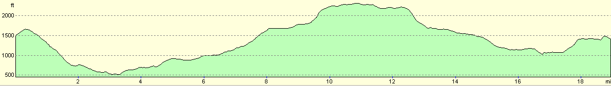
For more information on profiles, ascents and descents, see this page
Accommodation
I wild camped for the night beside a wall just to the south of the trig point at Rain Stang, on In Moor, at grid reference SE082755. If you wish to have a little more comfort, then the pub in Middlesmoor, a mile and a half along the track down the hill, has B&B facilities and allows camping.
Disclaimer
Please note that I take no responsibility for anything that may happen when following these directions. If you intend to follow this route, then please use the relevant maps and check the route out before you go out. As always when walking, use common sense and you should be fine.
If you find any information on any of these routes that is inaccurate, or you wish to add anything, then please email me.
All images on this site are © of the author. Any reproduction, retransmissions, or republication of all or part of any document found on this site is expressly prohibited, unless the author has explicitly granted its prior written consent to so reproduce, retransmit, or republish the material. All other rights reserved.
Although this site includes links providing convenient direct access to other Internet sites, I do not endorse, approve, certify or make warranties or representations as to the accuracy of the information on these sites.
And finally, enjoy your walking!
Nearby walks
| # | Title | Walk length (miles) |
|---|---|---|
| 35 | East Marton to Malham | 9.2 |
| 36 | Malham to Horton in Ribbesdale | 14.7 |
| 604 | Ilkley to Burnsall Fell | 21.0 |
|
|

|