Walk #589: Great Shelford to Haverhill
 |
 |
|
General Data
| Date Walked | 29/01/2004 |
| County | Cambridgeshire, Suffolk |
| Start Location | Great Shelford |
| End Location | Haverhill bus station |
| Start time | 08.56 |
| End time | 14.29 |
| Distance | 16.9 miles |
| Description | A nice and snowy walk, mainly following an old Roman Road through southeastern Cambridgeshire. |
| Pack | Today I carried my 30-litre Karrimor HotRock rucksack, which was filled with my waterproof leggings, water bottle, trainers and a couple of spare shirts, together with the usual assortment of odds and ends. |
| Condition | I feel absolutely fine after this walk, and I could easily have walked further if I had needed to. I had no significant problems, and my feet and legs are fine. |
| Weather | The last couple of days have seen significant snowfalls, and this has been coupled with a bitterly cold northerly wind. Fortunately today was nice and sunny, with scarcely a cloud in the sky. Although it was still bitterly cold the wind of yesterday had died down. All in all it was a superb day for a walk. |
| OS map | Landranger number 154 (Cambridge & Newmarket, Saffron Walden) |
 |
 |
|
 |
 |
|
Map of the walk
Maps courtesy of Google Maps. Route for indicative purposes only, and may have been plotted after the walk. Please let me have comments on what you think of this new format. For a detailed table of timings for this walk, please see the table file.
Notes
Yesterday I moved down from Derbyshire to the village of Great Shelford, to the south of Cambridge, ready for the start of my new job on Monday. Once I had arrived yesterday afternoon there was a very heavy snowstorm, coupled with lightning that dumped a couple of inches of snow on the ground. When I awoke this morning it was to traffic chaos on the roads, but the snowy scenes outside and bright, cloudless skies tempted me to do a walk to celebrate my new accommodation. Looking on the map it seemed that walking to Haverhill would be a good idea - it would be a modest sixteen miles, and for almost all the way I could follow an old Roman Road, now a by-way and devoid of traffic. The only slight snag was an interview on the radio with the manager of Stagecoach, who said that the busses from Haverhill to Cambridge were stopped due to the road being blocked. I decided to risk the walk anyway, assuming that in the six hours I would be walking the road would be cleared and I could get back.
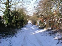
The pavements were slippy as I walked along the road that I live in, so I decided to walk along the edge of the road instead, which was slushy and therefore not slippy. I soon reached Graham's Road and I started the walk towards the old Roman Road, a stop at the level crossing for a train allowing me to put new batteries into my GPS. The fields alongside the road were snowy, and as the sun was still low in the sky some scenes looked absolutely magical. I crossed Wort's Causeway and started the climb up to the Roman Road and the Gog Magog hills. These roads were much clearer of snow and ice, and as I started he climb I passed another man with camera and tripod taking photographs of the scenes.
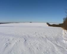
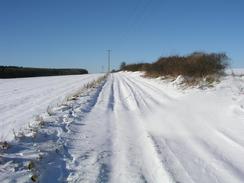
I was quite glad when I reached the Roman Road as it meant that I could get off the road for a significant distance. I had been hoping that I would be one of the first people to walk along the path and therefore the snow would be fairly virgin, but I soon discovered that several people had been cycling along the broad, unsurfaced track, and there were also a couple of pairs of footprints. This was not too bothersome, however, as I could position myself to miss most of these when I took photographs. It really was a superb day for a walk - the sun was ever-present and the snow in the surrounding fields glistened as the sun's rays hit it.
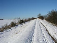
The Roman Road headed southeastwards, passing near to the Wandlebury hill fort and country park, and adjacent to Copley Hill, before descending down towards the bridge over the A11 road. For this entire long stretch I saw someone three or four hundred yards ahead of me, but as we were walking at roughly the same pace I never got any closer to him. As I headed further along the Roman Road the snow slowly got deeper, and the going consequently harder. The man ahead of me took a footpath that led off to the right down towards Hildersham, and I was left walking through virgin snow, the only tracks being those of numerous rabbits, some of which I occasionally saw as I strolled along.
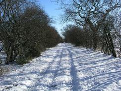
When I reached the Balsham to Hildersham road I was surprised to find an abandoned car beside the road, with banks of snow piled up on the side of the road. It looked as though a snowplough had thrown these up, but the car was sitting abandoned on the road away from these banks - it must have been ice on the road surface that stopped it. I looked around the car for a couple of minutes and took some photographs before heading off back down the Roman Road. The path climbed uphill passing to the north of Chilford Hall Vinery (where I had a lovely Christmas party many years before) before reaching the B1052 road. I progressed onwards for another couple of kilometres until I reached the next road near Mark's Grave. At this point the snow was quite deep and walking became quite hard; my legs started to suffer and I just kept plodding on until I reached the road near to the Cambridgeshire / Suffolk border.
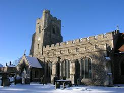
Once on the road the going was easier and I made good time, although it was still quite slipped underfoot. I soon reached the village of Horseheath, passing a pub that I was extremely tempted to nip into for a quick drink. The houses in the village are of a typical Suffolk variety, with pink painted walls and thatched roofs. The church in the village is particularly beautiful and was well set against the snowy scenes surrounding it, many of the gravestones having a white curtain of snow covering them. The village sign also had a covering of snow in places, adding to the rustic charm of the village.
I soon found myself back at the B1307 road, which I followed eastwards all the way into the centre of Haverhill. At the junction with the B1307 there were men building an access road into a new housing estate; obliterating yet more traces of the old Cambridge to Haverhill railway line in the process. On the way through the town I nipped into a petrol station to buy myself a chocolate bar and a packet of crisps; I had not eaten all day and I was exceptionally hungry, so a bite to eat came in handy.
Eventually I found myself at the bus station in the centre of Haverhill, and a bus that was ready to leave greeted me. Apparently the bus services had only started running at eleven O'clock, and because the roads were in such a state they were only going into the village of Linton on the way back; all other villages and local roads were being avoided. I was the only passenger for the entire journey and I chatted to the driver as he drove; a nice man, who was not even annoyed by the schoolchildren who threw snowballs at the bus as it passed. All in all although the scenery was not classic I am glad that I did the walk today; the snowy scenes are relatively rare in this part of the world, and so it was a good opportunity to walk in them. Spring will soon be upon us, and all chances of walking in snow will therefore sadly have gone. I find this attitude quie strange - since I seriously statred walking in 1999, I have tried to avoid walking in snow due to the risk of twisting my bad ankle. Now, however, I revel in it, and although I am not in the crampons and ice axe arena, I am enjoying walking through snow and ice, today and a few weeks ago on the high moors of Derbyshire.
Directions
This walk starts off at De-freville Road in Great Shelford; if you wish to start from the railway station then use the following directions: Turn right out of the station down Station Road. When this ends at a T-junction after a hundred yards, turn right to walk northwards through Great Shelford along the A1307 road. Pass the post office and then just before a railway bridge turn right to walk down Graham's Road. De-freville Road is the first road on the right.
Leave De-freville court and when the road ends turn right onto Graham's Road. Follow this as it heads over a level crossing and continues on northeastwards over White Hill, and when the road ends at the A1307 turn left for a few hundred yards until a traffic light controlled junction is reached. Turn right down Wort's Causeway; this road heads eastwards for a kilometre until it ends at a T-junction. At the junction turn right and then immediately left to continue on down Wort's Causeway as it heads up a slight hill. Shortly after it curves to the left pass a large steel building and turn right to join a track.
This track is called the Roman Road. After a few yards it turns to the right to head in a southeasterly direction across the Gog Magog hills; it passes close to Wendlebury Country Park and Copley Hill before descending towards the A11(T) road. Here the Roman Road crosses the A11(T) via a road bridge and once on the other side of the bridge continue on uphill along the Roman Road. This still continues in a southeasterly direction and it is very easy to follow as it crosses the Hildersham to Balsham road and a little over a mile later reaches the B1052 road.
Cross the B1052 and continue on along the Roman Road for a couple of kilometres until another road is reached near Mark's grave. Cross the road and take a bridleway that heads uphill in a roughly easterly direction, passing to the south of Streetly Hall before reaching West Wickham Road to the north of Horseheath. Cross the road and continue straight on along a footpath that heads uphill, heading near Hare Wood before slowly descending to meet Silver Street at the Cambridge / Suffolk border.
Turn left and follow this road as it heads northwards for a hundred yards; it then curves to the right to head northeastwards past Silver Street Farm and on past a pub into the village of Withersfield. Walk past the church and when a junction is reached by the village green and sign turn right to head south southeastwards along Queens Street for a mile until it ends at a T-junction with the A1307 road. At the T-junction turn left and follow the A1307 Withersfield Road as it heads along and northern outskirts of the town of Haverhill.
When the junction with the A143 is met turn left along it, and then immediately turn to the right to continue along the A143 (The Pightle) through the centre of Haverhill. When a roundabout is reached continue straight on across it; the bus station is almost immediately on the right.
Distances
| From | To | Distance (m) | Ascent (ft) | Descent (ft) |
|---|---|---|---|---|
| Great Shelford | B1052 road | 9.5 | 617 | 367 |
| B1052 road | Withersfield church | 5.2 | 302 | 325 |
| Withersfield church | Haverhill bus station | 2.2 | 49 | 121 |
This makes a total distance of 16.9 miles, with 968 feet of ascent and 813 feet of descent.
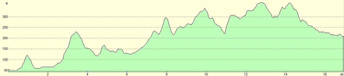
For more information on profiles, ascents and descents, see this page
Transport
There are regular bus services run by Stagecoach from Haverhill to Cambridge, and the C7 bus runs from Cambridge back to Little Shelford. Alternatively you could catch the train back from Cambridge to Little Shelford, although that involves a little under a mile walk from the bus station to the railway station in Cambridge.
Disclaimer
Please note that I take no responsibility for anything that may happen when following these directions. If you intend to follow this route, then please use the relevant maps and check the route out before you go out. As always when walking, use common sense and you should be fine.
If you find any information on any of these routes that is inaccurate, or you wish to add anything, then please email me.
All images on this site are © of the author. Any reproduction, retransmissions, or republication of all or part of any document found on this site is expressly prohibited, unless the author has explicitly granted its prior written consent to so reproduce, retransmit, or republish the material. All other rights reserved.
Although this site includes links providing convenient direct access to other Internet sites, I do not endorse, approve, certify or make warranties or representations as to the accuracy of the information on these sites.
And finally, enjoy your walking!
Nearby walks
| # | Title | Walk length (miles) |
|---|---|---|
| 2 | Waterbeach to Newmarket Road, Cambridge | 5.4 |
| 6 | Waterbeach to Newmarket Road, Cambridge | 5.4 |
| 7 | Waterbeach - Burwell - Swaffham - Waterbeach | 17.1 |
|
|

|