Walk #547: Lossiemouth to Portknockie
 |
 |
|
General Data
| Date Walked | 04/09/2003 |
| County | Grampian |
| Start Location | Lossiemouth |
| End Location | Portknockie |
| Start time | 07.22 |
| End time | 16.21 |
| Distance | 20.8 miles |
| Description | This was a wonderful walk, with very little road walking and lots of lovely coastal scenery. |
| Pack | Today I carried my 30-litre Karrimor HotRock rucksack, which was filled with my packed lunch, waterproof leggings, water bottle and a couple of spare shirts, together with the usual assortment of odds and ends. |
| Condition | I feel absolutely fine after this walk, and have had no problems. Both of my feet were fine and gave me no pain, which is more than a little relief. |
| Weather | Today was an absolutely superb day with lots of sunshine and relatively high temperatures. There was not a great deal of wind, and when it was cloudy this was high and thin. |
| OS map | Landranger number 28 (Elgin, Dufftown & surrounding area) |
 |
 |
|
 |
 |
|
Map of the walk
Maps courtesy of Google Maps. Route for indicative purposes only, and may have been plotted after the walk. Please let me have comments on what you think of this new format. For a detailed table of timings for this walk, please see the table file.
Notes
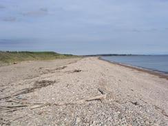
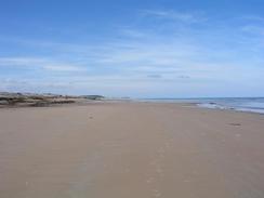
The weather was so nice when I first woke up this morning I decided that I would have another early start, and get a few miles under my belt before breakfast. For this reason I set off before seven thirty, and crossed over the wooden bridge over the River Lossie to gain access to the East Beach. The beach started off sandy, and this made for good walking for the first couple of miles as the sun slowly rose in front of me. Walking along beaches this early in the morning can be magical, and this morning was no exception. It was also nice to be the only person on the beach, which gave me a sense of solitude that was superb.
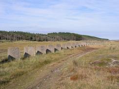
After a couple of miles the sand ran out and pebbles took over, which proved to be harder walking. To make progress faster I decided to climb over the shingle bank and walk along the track that ran behind it. This was much easier and in a way nicer - the views were not as expansive, but with the shingle bank to the left and the forest to the right I felt like I was walking along a corridor. Running down the middle of this corridor were a series of World War Two concrete anti-tank defences, with pillboxes every couple of hundred yards. This is the longest intact stretch of defences that I have seen on the coast, and they literally stretched for miles. I was amazed that the concrete cubes and pillboxes could remain intact for over sixty years, and the line stretching into the distance almost looked like a piece of modern art. About halfway along I came across a concrete observation post behind the cubes, and near to these were two large concrete gun positions and another observation post. I explored these for a while, and I could not help but wonder what it would have been like to be in these positions if they had come under attack. It was truly an amazing line of defences, and it made the walk along this stretch of beach truly memorable.
Sam was waiting for me in a little car park by the mouth of the River Spey at Kingston, and I went into Mervan for breakfast. As it was still relatively early and I had covered a good distance I did not mind having a long breakfast, and we chatted for ages as we looked out of the windows at the views.
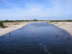
Once I left I walked south for a mile to Garmouth, where I found a plaque on the wall commemorating the place where King Charles II signed the Solemn League and Covenant in support of Presbyterianism on June 23rd 1656. From here I joined an old railway trackbed that is now path of the National Cycle Network Route 1. I was very glad of this, as it allowed me to cross the River Spey on a magnificent viaduct instead of having to walk many miles further south to the next bridge. The viaduct was exactly the sort of structure that I love - I guess that playing with Mechanno as a child rubbed off on me! The struts and members fascianted me, and the grand scale and design of the viaduct is so far away from modern bridges that I am very glad that it has been preserved, albeit for walkers and cyclists and not trains.
On the other side of the viaduct I joined the Speyside Way as it headed northwards towards the coast. I would follow this path on and off all the way to Buckie, and it felt strange to be on a waymarked and named path for the first time in ages. The Speyside Way is one of four Scottish National Trails, and the few miles that I saw of it has made me want to walk the entire one hundred miles of the trail - another walk to go on my 'ToDo' list.
I was quite impressed with Portgordon, and loved the houses that flanked the street. This was the first of what felt like an unbroken chain of little fishing villages for the next few miles, all looking like classic fishing villages - Portgordon, Buckie, Gordonbursgh, Findochty and Portknockie. I am quite amazed that such a small stretch of coast could have supported so many fishing villages, and it showed the power of the Herring fleets over the last couple of hundred years.
I met Sam in Buckie, and we walked together into the Harbour Bar for a drink. We started chatting to the barmaid and the first pint was quickly followed by another, after which we started talking to a Norwegian couple who were cycling around the North Sea. Communication was not easy, but we managed to understand each other quite well in the end, and they were a very interesting couple.
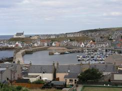
The long string of merged villages that came after Buckie were quite nice, and they included the large harbour at Gordonsburgh. As the A942 road was so near to the main road I just walked along this until after I passed Portessie, where a good path took me around into Findochty, which was pretty. The last couple of miles were along another footpath that took me to above the harbour in Portnockie, where Sam was waiting for me in Mervan.
When Sam was in Durness and I was at Cape Wrath she met a couple, Katie and Richard, who live in Lossiemouth. They had invited us over to stay for the night, and so as soon as I finished the walk we drove back to Lossiemouth. A lovely evening followed, and much alcohol was drunk. Katie and Richard were marvellous hosts, and Oscar, their young dog, added another nice element to the evening. We ended up going to bed after midnight, which was the latest that I had been up for some months, which shows exactly how much I was enjoying myself.
Directions
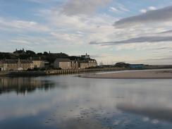
This walk starts off at the Gregory Place car park in Lossiemouth. Leave the car park and cross the wooden bridge over onto the east beach, and the turn right to start walking southeastwards along the beach. Fairly soon the sand ends and the beach becomes shingle; here you may find it easier to walk on a track behind the shingle ridge. Walk along the beach for seven and a half miles until the village of Kingston is reached, and then turn right to head south along the B9015 road for a mile into Garmouth.
In Garmouth turn left down a road and then turn left down some steps that leads to a cycle path that runs along an old railway trackbed. Follow this path eastwards for a kilometre as it crosses the River Spey on an attractive bridge, and on the other side turn left to head northwards along a track for a kilometre until a car park is reached in Tugnet.
At the car park turn right and head eastwards along the beach for a little over two and a half miles until a road is reached in Portannachy. Join this road and follow it as it skirts the shore into Portgordon, where it joins the A990 road and heads northeastwards into Buckie and on through Seattown, Gordonsburgh and Portessie. Shortly after Portessie turn left down a track as the A990 climbs uphill. The track passes a hotelnear Strathlene Sands and becomes a path that initially runs under the cliffs before climbing up and running along the top of the cliffs and descending into Findchty.
Walk around Findochty and pass the harbour before climbing uphill along a road onto the top of the cliffs, and then turn to the left to walk along a good path eastwards along the top of the cliffs. After a couple of miles the path joins a road in Portknockie, and follow this road around to above the harbour, where this walk ends.
Distances
| From | To | Distance (m) | Ascent (ft) | Descent (ft) |
|---|---|---|---|---|
| Lossiemouth | Kingston | 7.7 | 105 | 105 |
| Kingston | Buckie | 7.1 | 285 | 230 |
| Buckie | Portknockie | 6.0 | 492 | 453 |
This makes a total distance of 20.8 miles, with 882 feet of ascent and 788 feet of descent.
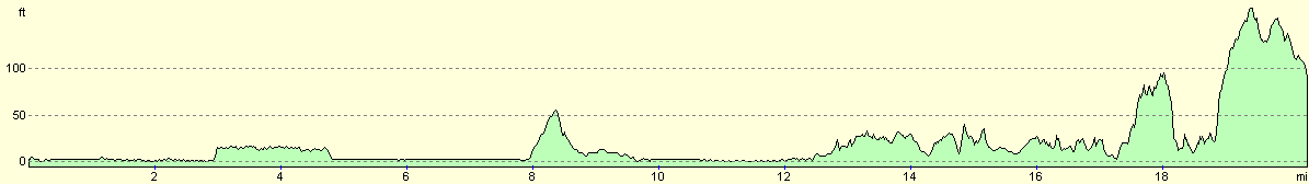
For more information on profiles, ascents and descents, see this page
Accommodation
We spent the night in the house of some friends in Lossiemouth - it felt very strange to be sleeping in a proper bed for once!
Disclaimer
Please note that I take no responsibility for anything that may happen when following these directions. If you intend to follow this route, then please use the relevant maps and check the route out before you go out. As always when walking, use common sense and you should be fine.
If you find any information on any of these routes that is inaccurate, or you wish to add anything, then please email me.
All images on this site are © of the author. Any reproduction, retransmissions, or republication of all or part of any document found on this site is expressly prohibited, unless the author has explicitly granted its prior written consent to so reproduce, retransmit, or republish the material. All other rights reserved.
Although this site includes links providing convenient direct access to other Internet sites, I do not endorse, approve, certify or make warranties or representations as to the accuracy of the information on these sites.
And finally, enjoy your walking!
This walk was mentioned in the following routes:
| My walk around the coastline of Britain |
Nearby walks
| # | Title | Walk length (miles) |
|---|---|---|
| 546 | Findhorn to Lossiemouth | 17.0 |
| 548 | Portknockie to Macduff | 19.0 |
|
|

|