Walk #516: Blarnalearoch to Strathcanaird
 |
 |
|
General Data
| Date Walked | 01/08/2003 |
| County | Highlands |
| Start Location | Blarnalearoch |
| End Location | Strathcanaird |
| Start time | 08.58 |
| End time | 17.03 |
| Distance | 19.0 miles |
| Description | This was quite an enjoyable road plod up and down Loch Broom, taking in Ullapool. |
| Pack | Today I carried my 30-litre Karrimor HotRock rucksack, which was filled with my packed lunch, waterproof leggings, water bottle and a couple of spare shirts, together with the usual assortment of odds and ends. |
| Condition | I had no problems with the walk itself today, but I did suffer from my cough, which has slowly got worse over the last couple of days. I was quite lethargic through today, and I was glad that the walk was along roads and far from strenuous. If this does not get any better then I may be forced to take a day off. |
| Weather | The most notable feature of today's weather was the wind, which was gusting quite strongly at times. Fortunately the day was mostly dry, but it was the coldest day for some time, and never really seemed to warm up. In the afternoon there were some periods of drizzle, but as the rain as coming from behind me that did not matter as much. Later on in the evening the rain got harder and the wind stronger, so I was glad that I had already finished the walk. |
| OS map | Landranger number 20 (Beinn Dearg & Loch Broom, Ben Wyvis), Landranger number 19 (Gairloch & Ullapool, Loch Maree) and Landranger number 15 (Loch Assynt, Lochinver & Kylesku) |
 |
 |
|
 |
 |
|
Map of the walk
Maps courtesy of Google Maps. Route for indicative purposes only, and may have been plotted after the walk. Please let me have comments on what you think of this new format. For a detailed table of timings for this walk, please see the table file.
Notes
I woke up this morning to an unusual sensation that I have not felt for sometime - cold. I was coughing and spluttering away as soon as I awoke, and once I got up it was clear that this was the coldest morning for some time. It was not the bitter cold that we had during winter, but more of a nip in the air that was most unwelcome. To combat this I put the heater on for five minutes, and had to put up with the smell of the dust that had accumulated inside the heater over the last few months burning. I also made myself a coffee to help warm myself up, and once I had drunk this I was fine.
The weather looked as though it could do anything - one minute the sun was shining, and the next there was a big black cloud overhead. The wind was gusting quite strongly, and so I knew that I was probably going to get wet during the day, as the clouds would be blown in and away quite fast. Despite the fact that I was not firing on all cylinders I was quite looking forward to the walk, and as I wanted to spend some time in Ullapool I set off early.
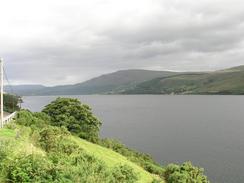
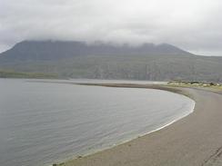
The early stretch of the walk down Loch Broom to near Inverlael and up the northern bank was along roads, and as only enlivened by occasional views over the loch. I found the walk along the A835(T) road to be quite boring and the road was surprisingly busy (when I walked along the A835(T) further east last year it was nowhere near a busy as it as today), and so I was very glad when I dropped down into the charming fishing town of Ullapool. It had been my intention to walk through Ullapool on a previous walk that did not materialise, and so I was very much looking forward to seeing the town. Ullapool became famous as being a place where factory ships visit, and indeed there two or three large ships moored in the loch a short distance away from the town.
I met Sam in Ullapool, and we walked to a chemists to get some cough syrup to try to get rid of the annoying cough, but unfortunately this did not work. As Ullapool is he last large town that we will be in for a few weeks, we decided to treat ourselves to a meal, and so we found a restaurant that we could sit in to eat fish and chips, which made a nice change from sandwiches for lunch. We made this drag out, as I wanted to use the Internet and the library did not reopen until two. I spent forty-five minutes on the 'net, mainly replying to emails and doing some research ready for he end of the trip, which we are starting to have to plan in more detail. I find the whole thought of ending the trip quite overwhelming, and not a little depressing, so I am leaving Sam to organise most of it.
I was extremely tempted to end the walk at Ullapool, mainly as I was not feeling particularly strong and energetic. I knew however that doing the extra six miles north of the town would leave me in a much better position to start the rough walk west under Ben Mor Coigach, which promises to be quite hard going. I prefer to do rough walks first thing in the morning, as I am freshest then and generally find them easier and more enjoyable than if I do them at the end of the day when I am tired. If I add the fact that I am feeling quite unwell to the equation, then that extra six miles may well have been a good idea.
Sam has to drive the van all the way over to Inverness tomorrow to get it MOT'd. The MOT is due on the nineteenth, so we have plenty of time to get any problems repaired (not that I am expecting any of significance), but I was hoping that we could have had the MOT done in Ullapool. Unfortunately Mervan is too big to fit on any of the ramps at MOT garages in Ullapool, so Sam has to take it to Inverness. I was dismayed when she told me this on the phone as I thought that it would be a long drive, but when I looked at a road map I found that it was only about fifty miles away.
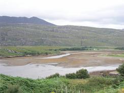
This evening I was looking at the three maps that I used today and I realised that I did not take the best route at the end of today's walk. At the top of map 19 there is a track running past Keanchulish House, and I did not realise that this track continued on the top of the next map, and would have made a better route that the walk along the main road, although this stroll was not too bad as the road was not busy; the route that I took also allowed me to do a longer day as Sam could pick me up later than would otherwise have been the case.
Directions
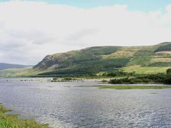
This walk starts about a hundred yards south of the end of the road in Blarnalearoch. Follow the road as it heads southeastwards along the southern bank of Loch Broom along a quiet road. At Clachan it passes a small church and continues in to a T-junction. Turn left to head eastwards along a tree-lined road for a short distance to a bridge over the River Broom, after which the road ends at a T-junction with the A835(T) road. Turn left and follow the A835(T) road northwards as it passes through Inverlael and then joins the eastern bank of Loch Broom, which it follows as it slowly curves northwestwards into Ullapool.
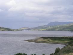
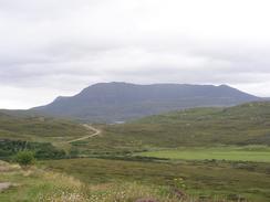
I ventured into Ullapool because I had things to do there, but if you do not want to then continue on along the A835(T) as it climbs out of the town and descends to a bridge over the Allt an t-Srathain. It then climbs up over another little hill and descends to Ardmair. The road then curves to head northeastwards, climbing up through a rocky valley before descending down into Strath Canaird. This walk ends at a little car park on the right immediately before the bridge over the River Canaird.
Distances
| From | To | Distance (m) | Ascent (ft) | Descent (ft) |
|---|---|---|---|---|
| Blarnalearoch | River Broom | 4.8 | 479 | 640 |
| River Broom | Pier in Ullapool | 7.5 | 814 | 853 |
| Pier in Ullapool | Strathcanaird | 6.7 | 883 | 833 |
This makes a total distance of 19.0 miles, with 2176 feet of ascent and 2326 feet of descent.
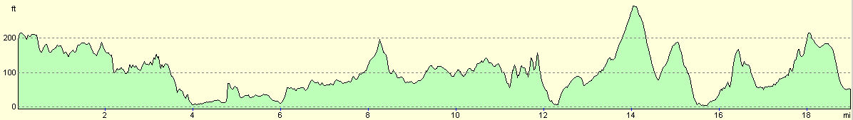
For more information on profiles, ascents and descents, see this page
Accommodation
We parked Mervan in a little car park that is on the southern side of the River Canaird, near a couple of houses. There was a large sign stating no overnight parking, but the car park was so handy that we could not resist the temptation to park there.
Disclaimer
Please note that I take no responsibility for anything that may happen when following these directions. If you intend to follow this route, then please use the relevant maps and check the route out before you go out. As always when walking, use common sense and you should be fine.
If you find any information on any of these routes that is inaccurate, or you wish to add anything, then please email me.
All images on this site are © of the author. Any reproduction, retransmissions, or republication of all or part of any document found on this site is expressly prohibited, unless the author has explicitly granted its prior written consent to so reproduce, retransmit, or republish the material. All other rights reserved.
Although this site includes links providing convenient direct access to other Internet sites, I do not endorse, approve, certify or make warranties or representations as to the accuracy of the information on these sites.
And finally, enjoy your walking!
This walk was mentioned in the following routes:
| My walk around the coastline of Britain |
Nearby walks
| # | Title | Walk length (miles) |
|---|---|---|
| 515 | Little Gruinard to Blarnalearoch | 20.3 |
|
|

|