Walk #514: Poolewe to Little Gruinard
 |
 |
|
General Data
| Date Walked | 30/07/2003 |
| County | Highlands |
| Start Location | Poolewe |
| End Location | Little Gruinard |
| Start time | 09.58 |
| End time | 16.56 |
| Distance | 19.8 miles |
| Description | This was an enjoyable walk, mostly along roads but also including one stretch along tracks and unpathed moorland. |
| Pack | Today I carried my 30-litre Karrimor HotRock rucksack, which was filled with my packed lunch, waterproof leggings, water bottle and a couple of spare shirts, together with the usual assortment of odds and ends. |
| Condition | I feel absolutely fine after this walk, and aside from some aching in my neck I have had no trouble. The underside of my feet were fine, |
| Weather | Today was the first totally dry day for ages, with no sign of any rain. There was a fair amount of cloud, but there were also some prolonged sunny periods, which made for a wonderful day for a walk. |
| OS map | Landranger number 19 (Gairloch & Ullapool, Loch Maree) |
 |
 |
|
 |
 |
|
Map of the walk
Maps courtesy of Google Maps. Route for indicative purposes only, and may have been plotted after the walk. Please let me have comments on what you think of this new format. For a detailed table of timings for this walk, please see the table file.
 |
Notes
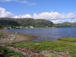
I woke up early this morning and got up to do some work writing up notes on the computer, taking advantage of the fact that I had mains power. This did not take too long, and I then went out with my camera to take some pictures. The panoramic photos that I took the other day did not work out, and so having reread the manual I wanted to try again. I had noted yesterday that the view from the south end of Loch Ewe may make a good photo, and fortunately this time it worked out quite well, and I have a nice panoramic photo of Loch Ewe. This is a function of my camera that I could have used much more on this trip, and hopefully I shall use it a lot more over the next couple of months.
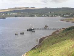
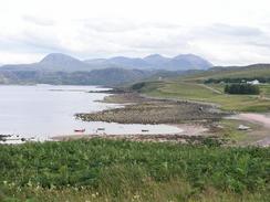
The first few miles were along the A832 road, and afforded some lovely views over Loch Ewe, particularly from one viewpoint about a mile to the north of Tournaig. A little further on I came across the pier of a NATO POL (Petroleum, Oil, Lubricants) station, and I could look down on some of the oil storage tanks and bund walls, all nicely covered with grass (a militaristic mind obsessed with camouflaging everything perhaps?). I have passed a fair few of these POL stations on the west coast of Scotland, and I have been impressed with how well they are landscaped into the surrounding hillsides - perhaps certain industries could learn from this. I wonder if the existence of a POL station is a hangover from the World Wars, where Loch Ewe was a massively important naval base, taking over from Scapa Flow for a period, and be8ing used for the assembly of convoys to Russia.
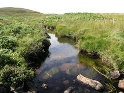
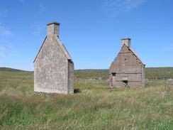
Aultbea was quite a nice little village, strung along a road beside the foreshore of Loch Ewe and facing the Isle of Ewe. As I walked through the village a large docile dog attached itself to me and kept on muzzling me, but fortunately after a couple of minutes of this a local came along and took the dog off me. Sam had been intending to meet me in Mellon Charles, but unfortunately she was unavoidably detained and so she could not make it. This left me with a slight problem as I was wearing trainers and I knew that I had a section of unpathed moorland to walk across. After a little thought I decided to continue on even though I was wearing trainers and did not have my walking poles with me. I am very paranoid about twisting my left ankle, and as my trainers do not give much support it was not an easy decision. A track took me from Mellon Charles to the top of a hill before ending, and left me with a gap of about a mile to reach the ruins at Slaggan, where I could join a track. Fortunately the moorland was not too rough, but three were some quite steep sections that I had to take carefully. Eventually I made it through to Slaggan and crossed a little river that empties into Slaggan Bay and walked past the ruined buildings.
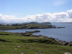
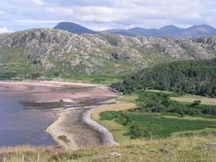
I decided not to walk around the rest of the peninsular to Greenstone Point, but to walk east from Slaggan along a good track for three miles to meet the road once again. I enjoyed this walk immensely, and it was with regret that I joined the road once more, heading south for a short distance to near Achgarve, where Sam was waiting for me. I had lunch, before setting off to walk to Laide, where I descended onto the beach and walked through a caravan park to gain access to the A832 road. The walk eats from here passed through the strangely named 'First Coast' and 'Second Coast', before eventually descending down to Little Gruniard.
The car park was exceedingly busy when I finally arrived, and the attractive stretch of beach was seemingly filed with people. Sam had initially had trouble finding somewhere to park, but as the tide stated to come in people started to leave and she got in. I can see why the beach is so popular - it is a small but attractive beach, with good access. Couple this with today's great weather and I could understand why people were swimming. The only bad thing was that a cloud of midges came out this evening, which prevented us from going out to look at the beach.
I am yet again in a quandary about what to do tomorrow - I can either aim to get beyond the Altnaharrie Hotel, which will be more than twenty miles, or end the walk before I reach the hotel, which will be a short day. There is little room for a compromise between these two options, and so I shall probably make the decision when I see what the weather is like in the morning.
Directions
This walk starts off at the caravan site in Poolewe. Leave the campsite and turn right to head northeastwards along the A832 road as it heads past Inverewe Gardens and climbs and falls to reach Loch Thurnaig and Tournaig. The road then climbs uphill to the north high onto a hillside with some lovely views over Loch Ewe, before descending down via a hairpin bend and reaching the outskirts of Aultbea. Take the first road to the left and follow it as it skirts the foreshore through Aultbea and passes Aird Point before reaching Ormiscaig and Mellon Charles.
When the road ends in Mellon Charles continue straight on along a track that climbs north up a hill, before ending at the top of the hill. From here head north for a little under a mile across trackless moorland. Some of the descents are very steep, so it may be best to head slightly away from a northerly course to avoid the worst crags. Eventually you will reach a stream, which I crossed using some handy boulders, and a small climb takes you to the ruined crofts of Slaggan. From the ruins a good track heads eastwards for about three miles before ending at a road.
Turn right to head southeastwards along this road past the junction with the road to Achgarve, after which the road turns to head in a more southerly direction towards Laide. On the northern outskirts of the village turn left down a path that descends past a ruined chapel to reach the beach. Turn right and almost immediately cross a little stream and then walk through a caravan park to reach the A832 road. Walk east along the A832 as it climbs up through First Coast and Second Coast, before descending steeply to Little Gruniard. This walk ends a kilometre to the east of Little Gruniard, in a car park beside the Inverianvie River.
Distances
| From | To | Distance (m) | Ascent (ft) | Descent (ft) |
|---|---|---|---|---|
| Poolewe | Aultbea | 6.5 | 636 | 633 |
| Aultbea | Laide | 9.0 | 938 | 889 |
| Laide | Little Gruinard | 4.3 | 607 | 571 |
This makes a total distance of 19.8 miles, with 2181 feet of ascent and 2093 feet of descent.
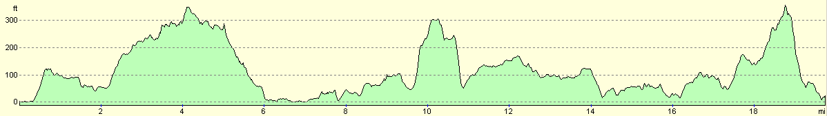
For more information on profiles, ascents and descents, see this page
Accommodation
We spent the night at the car park by the beach a kilometre to the east of Little Gruinard, at grid reference NG 952899. Although there were no facilities nearby, the views and adjacent beach more than made up for this.
Disclaimer
Please note that I take no responsibility for anything that may happen when following these directions. If you intend to follow this route, then please use the relevant maps and check the route out before you go out. As always when walking, use common sense and you should be fine.
If you find any information on any of these routes that is inaccurate, or you wish to add anything, then please email me.
All images on this site are © of the author. Any reproduction, retransmissions, or republication of all or part of any document found on this site is expressly prohibited, unless the author has explicitly granted its prior written consent to so reproduce, retransmit, or republish the material. All other rights reserved.
Although this site includes links providing convenient direct access to other Internet sites, I do not endorse, approve, certify or make warranties or representations as to the accuracy of the information on these sites.
And finally, enjoy your walking!
This walk was mentioned in the following routes:
| My walk around the coastline of Britain |
Nearby walks
| # | Title | Walk length (miles) |
|---|---|---|
| 512 | Shieldaig to Melvaig | 14.7 |
| 513 | Melvaig to Poolewe | 18.3 |
|
|

|