Walk #485: Craobh Marina to Kilmore
 |
 |
|
General Data
| Date Walked | 29/06/2003 |
| County | Strathclyde |
| Start Location | Craobh Marina |
| End Location | Kilmore |
| Start time | 08.47 |
| End time | 17.21 |
| Distance | 24.0 miles |
| Description | This was a long but rewarding day, with a varied walk along roads and hill tracks. |
| Pack | Today I carried my 30-litre Karrimor HotRock rucksack, which was filled with my packed lunch, waterproof leggings, water bottle and a couple of spare shirts, together with the usual assortment of odds and ends. |
| Condition | I am quite fatigued after this walk, but aside from this I had no significant problems. My right shoulder ached for a few hours, which was annoying but nothing more than that. |
| Weather | today was a lovely, sunny day. In the morning there was scarcely a cloud in the sky, but in the afternoon it slowly started to cloud over, which I was quite glad about as it kept the temperature down. There was not much wind, and there was absolutely no sign of any wind. |
| OS map | Landranger number 55 (Lochgilphead & Loch Awe) and Landranger number 49 (Oban & East Mull) |
 |
 |
|
 |
 |
|
Map of the walk
Maps courtesy of Google Maps. Route for indicative purposes only, and may have been plotted after the walk. Please let me have comments on what you think of this new format. For a detailed table of timings for this walk, please see the table file.
 |
 |
|
 |
 |
|
Notes
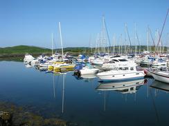
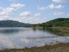
When I woke up this morning I went outside to have a walk around the harbour, which looked beautiful as the sun was glistening on the water. There were many boats in the marina, and even at the early hour there were people milling about on them. I did not sleep very well during the night, even though I had a (for me) late night. Unfortunately a short distance away at the pier there was a party going on, and the music lasted until three in the morning and often woke me up. When it did wake up I found it very hard to get back to sleep again, and after a while this got annoying. The sound was actually bouncing off the hotel and so there was a very slight echo effect to all the beats. I was determined to get too annoyed, as we were being slightly naughty by staying in the car park this morning.
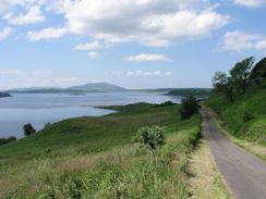
The first part of todays walk was along the A816, which was not too busy at that time of the morning. There were not many good views, but the road allowed me to make some fairly good progress. I seemed to be overtaken be a near-endless stream of motorcycles, some going so fast that they were going onto the other carriageway on blind bends - an easy way to die, if you ask me. I as glad when I reached the turn off for the road to Melfort, as it promised to be a more serene walk.
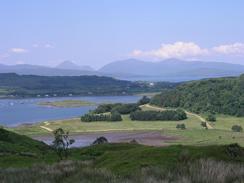
I stopped for lunch where the road meets a track at Degnish, and I had a wonderful vista over Loch Melfort. It was a superb place to have lunch, and I was very tempted to stay longer. As usual though the walk called me, so I set off on an absolutely superb stretch of walk over the hill to Ardmaddy Bay. The route was mostly along a good track that allowed good progress, and there were some great views over towards Seil and Mull. If the entire walk could be like this one small stretch then I think that there would be thousands of people doing it; it really was superb. The glorious weather helped create this impression, and I daresay that if it had been raining then I would feel very differently about it, as it was quite an exposed track.
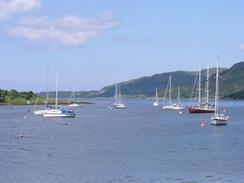
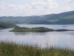
Once I had reached Caddleton I followed a surfaced track that headed past the beautiful Ardmaddy Bay and rose up past Ardmaddy Castle. The views across Seil Sound from here were very nice, especially as the sun was glinting on the surface of the water. I met Sam a little further north on the B844 near Loch Seil, and I sat down to watch the end of the European Grand Prix, which was fairly exciting. I had done seventeen miles today and I could easily have finished the walk there, but I still felt fit and there were plenty more hours in the day, so I decided to continue on and walk the rest of the way to Kilmore.
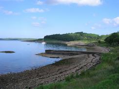
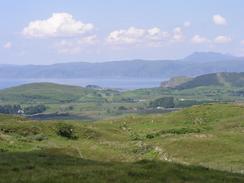
The rest of the walk was a fairly boring and straightforward road plod along the B844 and A816; the views over Loch Feochan were very nice, but this did not make up for the fact that it was a road walk. This area of Scotland is exceedingly beautiful and it is a shame that there are not more coastal paths or tracks that can be followed; one of the reasons for there not being is that the roads hog all the flat land, which is generally found along the sides of the lochs. Despite this there are areas where there are no roads that are crying out for proper paths to be created, and it is nice that the forestry commission have created some cycle paths through their forests; these proved to be extremely useful the day before yesterday.
I am quite pleased that today was such a long day and that I got a reasonable distance completed. It may be nice to get to Fort William by the day after tomorrow, which will be pushing it and will probably involve walking at least twenty miles a day. It would be nice if I could climb Ben Nevis the day afterwards (having already climbed Snowdon and Scafell Pike on this trip so far), but that would be fairly dependant on the weather. I have climbed Ben Nevis before, so if I was not to climb it then it would not be a disaster. Fort William has been a target of mine ever since I left Somerset, and it will be absolutely great to reach there.
Directions
This walk starts off at Craobh Marina. Leave the marina and walk along the access road that leads on for about a mile until it ends at the A816 road. At the junction turn left to head northwestwards along the A816 road, which soon curves to head northward past Arduaine and then northeastwards past Kames Bay. Just before Kilmelford is reached turn left down a road that heads past Melfort, before curving around Fearnach Bay and heading westwards along the northern edge of Loch Melfort. The road curves around above Kilchoan House and continues on for about a kilometre southwestward until it nears Degnish. At a gate the public road ends, and a track heads away sharply to the right beside dome power lines.
Follow this track northwards for a couple of miles, and when it turns to head northeastwards at grid reference 788154 head straight on down a path that heads downhill to the farm at Caddleton; there were several alternative paths here, and I chose one that took me down to a track by the farm. When the track is reached turn right and follow it northwards past Ardmaddy Bay and Ardmaddy Castle. The track soon becomes a public road and continues on for a couple of miles until a junction with the B844 is reached. Continue straight on down the B844 road, which heads northeastwards along the northern bank of Loch Seil. The road curves around and when it enter Kilinver and crosses the River Fuchar turn to the left to head northeastwards along the B844. After a mile this road joins the A816 road; turn left and follow this road along the southern bank of Loch Feochan. When the loch ends the road curves around it's end to head northwards, and this walk ends at a lay-by beside a phone box, a few yards past the junction with the road that leads off to Kilmore on the right.
Distances
| From | To | Distance (m) | Ascent (ft) | Descent (ft) |
|---|---|---|---|---|
| Croabh Marina | Melfort | 7.9 | 981 | 981 |
| Melfort | Kilninver | 11.6 | 2057 | 2024 |
| Kilninver | Kilmore | 4.5 | 348 | 358 |
This makes a total distance of 24.0 miles, with 3386 feet of ascent and 3363 feet of descent.
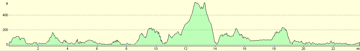
For more information on profiles, ascents and descents, see this page
Accommodation
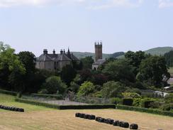
We spent the night at the Oban Divers Caravan Park, Glenshellach Road, Oban, Argyll, Highlands PA34 4QJ. This site was absolutely superb and was very well cared for. The site should have cost us ten pounds fifty pence for the night, but they very kindly knocked two pounds fifty off for us. They can be contacted on (01631) 562755, or on the web at www.obandivers.co.uk.
Disclaimer
Please note that I take no responsibility for anything that may happen when following these directions. If you intend to follow this route, then please use the relevant maps and check the route out before you go out. As always when walking, use common sense and you should be fine.
If you find any information on any of these routes that is inaccurate, or you wish to add anything, then please email me.
All images on this site are © of the author. Any reproduction, retransmissions, or republication of all or part of any document found on this site is expressly prohibited, unless the author has explicitly granted its prior written consent to so reproduce, retransmit, or republish the material. All other rights reserved.
Although this site includes links providing convenient direct access to other Internet sites, I do not endorse, approve, certify or make warranties or representations as to the accuracy of the information on these sites.
And finally, enjoy your walking!
This walk was mentioned in the following routes:
| My walk around the coastline of Britain |
Nearby walks
| # | Title | Walk length (miles) |
|---|---|---|
| 484 | Crinan to Craobh Marina | 18.1 |
|
|

|